Rhode Island
Bullets scattered on Rhode Island roadway after wild pursuit of vehicle laden with ammo

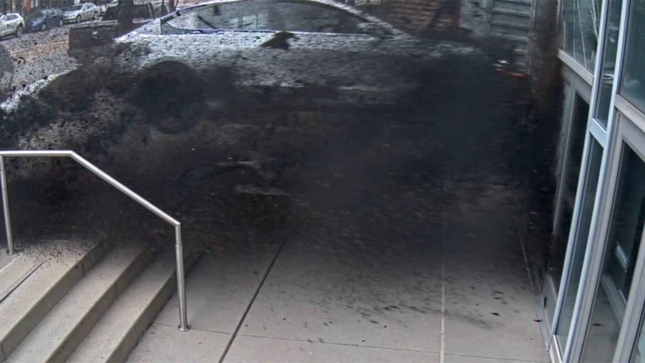
EAST PROVIDENCE, R.I. (AP) — Law enforcement officials brought more than 100 counts against a Florida motorist accused of firing shots at a residence before leading officers on a wild pursuit in which two cruisers crashed into a house and several other vehicles were damaged, officials said.
The motorist remained in jail on Sunday, two days after the chase ended with his SUV crashing and spilling bullets and cartridges on a roadway in East Providence, police said.
“This was an extremely volatile situation involving a dangerous and unpredictable suspect who put so many of our residents and police officers in harms way,” Police Chief Christopher Francesconi said.
The episode unfolded Friday with reports of shots fired from a vehicle with Florida license plates. Police gave chase before the suspect crashed and abandoned his vehicle, fled on foot and was arrested. More than 1,000 rounds of ammunition were recovered from the vehicle, and several guns were found in a backpack discarded on the chase route, police said.
Charges included 106 counts of possessing a large capacity feeding device, discharging a weapon from a vehicle, eluding an officer, and obstructing officers. The investigation continued over the weekend as the motorist remained in jail. It was not immediately clear if he had an attorney, police said.


Rhode Island
Major hurricane season predicted; insurers aren’t taking chances • Rhode Island Current

Unless a ton of climate and weather scientists are wrong, the U.S. could be in for the worst Atlantic hurricane season ever.
“This season is looking to be an extraordinary one,” said Rick Spinrad, administrator of the National Oceanic and Atmospheric Administration, Thursday morning at a briefing to announce NOAA’s predictions for the upcoming hurricane season, which starts on June 1 and runs through Nov. 30.
NOAA is predicting an 85% chance of an above-normal season, with 17 to 25 named storms, eight to 13 hurricanes and four to seven major hurricanes, which are those that have sustained winds of at least 111 mph — categories 3, 4 and 5.
“The forecast for named storms, hurricanes and major hurricanes is the highest NOAA has ever issued for the May outlook,” Spinrad said.
The forecast is in keeping with several earlier forecasts, including one issued by Colorado State University. Nearly two months ago, CSU predicted a very active season with 23 named storms, 11 to become hurricanes and five major hurricanes. It was the highest prediction for hurricanes that CSU has ever issued in its April outlook, which began in 1995.
Climate change is part of the culprit. It has caused unprecedented warmth in the oceans, which means there is more fuel for storms. Matthew Rosencrans, NOAA’s lead hurricane forecaster, said sea surface temperatures in the main storm development area are where they would normally be in August — that’s 2 to 3.5 Fahrenheit degrees above normal for this time of year. Another factor is the cyclical weather pattern known as La Niña, which is expected in late summer. It is conducive to more active hurricane seasons because its low wind shear conditions allow storms to stay intact. Forecasters are also seeing active African monsoons. The warm water just makes everything worse.
“It’s really the confluence of factors,” Rosencrans said.
It could be not a single storm hits land anywhere, nevermind this part of the Atlantic basin. But as the longstanding mantra goes, repeated multiple times during NOAA’s announcement: it only takes one. Witness 1992, predicted to be a very mild hurricane year. And indeed that was the case, with fewer than a handful of hurricanes. But one of them was Andrew. To this day it remains among the worst hurricanes to strike the U.S., devastating south Florida and parts of the Gulf coast.

As many in Connecticut’s shoreline communities have already discovered, or may discover soon, insurance companies are not taking chances. Homeowners insurance rates are increasing — by double digits year-over-year, in some cases. And what’s known as a “hurricane deductible,” once a rarity, is now close to ubiquitous.
To be clear, some of this is a result of the continuing COVID legacy of inflation and supply chain difficulties. Replacement costs for homes are just higher than they used to be. But a great deal, if not most of it, is a function of the massive payouts insurance companies have faced from natural disasters that are more frequent and extreme, courtesy of climate change. In the west, it’s wildfires. On the East and Gulf Coasts, it’s storms.
Understanding what an insurance company does or doesn’t cover, what Connecticut allows or requires it to cover, and the minefields that may be all over insurance policies can be nothing short impenetrable.
Here’s what to know:
Homeowners insurance is not flood insurance
If wind from a hurricane or any other kind of storm blows pieces of your house off or dumps a tree on your roof causing damage, homeowners insurance should cover it (at least after the deductible).
If rain from that same storm or hurricane floods and wrecks your ground floor, homeowners insurance will not cover it. You’d need flood insurance, which is required in many, but not all, cases.
On the other hand, if the tree that lands on your roof makes a big hole and rain comes pouring through the hole, that should be covered by homeowners insurance.
How a hurricane deductible works
Insurance policies typically have a deductible, which is the amount you have to pay off the top before insurance starts paying. It is typically a flat amount of money.
A hurricane deductible is the same in that it’s the amount you have to pay off the top, but it’s different in that the amount is a percentage of the value of the structure. So if your homeowners policy values your home at $500,000, a 5% hurricane deductible means you would have to pay $25,000 out of pocket before insurance would cover anything. A 2% deductible would mean you’d have to pay $10,000.
To be clear, the deductible is based on the value of the dwelling, not on the cost of the repair. If a hurricane wrecks your roof and the cost of repair is $20,000 and your deductible is $25,000, you’re going to have to pay for the whole thing.
The benefit of a hurricane deductible is that the overall cost of the insurance policy stays lower.
Hurricane deductibles can be used only in parts of Connecticut
Insurance is regulated by states, so the rules in Connecticut most likely will not be the same everywhere.
Hurricane deductibles are only allowed in coastal area communities — the 24 that border Long Island Sound, plus another nine that are close: North Branford, Orange, Essex, Deep River, Chester, Killingworth, North Stonington, Ledyard and Lyme.
For homes within 2,600 feet of the shoreline as the crow flies — that’s just about a half-mile — companies may impose a hurricane deductible up to 5%. Beyond that distance within those communities, they can only go up to 2%. In each case, they can go to a lower percentage but not a higher one.
In some policy renewal cases for homes more than 2,600 feet from the coast, the use of already-existing storm shutters or other mitigation such as impact-resistant glass can nullify a hurricane deductible requirement.
When can a hurricane deductible be activated?
In Connecticut, insurance companies may activate a hurricane deductible only if, during the time the National Hurricane Center has a hurricane warning in place anywhere in the state, through 24 hours after that warning is removed or downgraded, there is a sustained wind of more than 74 miles per hour anywhere in the state. (As defined by NOAA, sustained wind is an average of wind speed at a given location over a two-minute period.)
That statute was put in place after the confusion around Tropical Storm Irene in 2011 and Storm Sandy in 2012. Both storms had been downgraded by the time they reached Connecticut. The last storm to score a direct hit on Connecticut as a hurricane was Gloria in 1985.
Since it was clarified, the updated hurricane deductible policy has never been triggered.
Wind/hail deductibles
This is another product insurance companies are using in storm-prone areas to help them recoup losses. Like hurricane deductibles, they can help lower the cost of an insurance policy. But they do not need a trigger the way a hurricane deductible does. Nor are they capped at certain percentages.
“If you have a wind/hail deductible on your policy, it can be applied at any time; you don’t need a hurricane,” said George Bradner, assistant deputy commissioner and director of the property and casualty division at the Connecticut Insurance Department. “It’s important for consumers to understand that if they accept a wind/hail deductible in lieu of a hurricane deductible, anytime the wind blows, they could have that deductible apply.”
In the end, wind/hail deductibles could wind up costing homeowners more, given the prevalence of extreme storms in recent years. They are allowed in all parts of the state, but they cannot be mandated by insurance companies.

Gray areas remain
Take a storm like Sandy, which occurred in 2012. Scientifically, it was considered a post-tropical cyclone at the time it made landfall in New Jersey, even though it had maximum sustained winds that were hurricane force (80 mph). Therefore, the National Weather Service could not issue a hurricane warning. There was much debate afterward over whether that classification caused residents of New Jersey in particular to not take the storm as seriously as they should have. Sustained winds from Sandy did not meet hurricane criteria in Connecticut.
The National Hurricane Center, in an email response to how Sandy would be handled now, said: “The change made after Sandy is that the NWS can issue and maintain hurricane/tropical storm/storm surge watches and warnings for systems that are expected to transition from a tropical cyclone to a post-tropical cyclone near land.” For internal purposes, such a storm would still be considered a post-tropical cyclone. “But we can use watches and warnings to communicate wind and storm surge risks despite the classification.”
What would that mean for a hurricane deductible trigger? We don’t know.
“Each situation is going to have to be looked at and reviewed by the department,” Bradner said. “We’ll look at the statute, we’ll meet with our lawyers and with the commissioner and we’ll make a determination if a deductible can or cannot apply.”
NOAA also unveiled a new version of its well-known cone that shows on a map where a hurricane is likely to go. The new version, which is experimental for the upcoming season, will show more broadly where impacts from a hurricane might reach beyond the standard cone, and what those impacts might be. What might that eventually mean for a hurricane deductible trigger? We don’t know that either.
Minefields
Getting the correct information, knowing the terminology, checking the rules and being aware of what’s in an insurance policy can be among the most challenging parts of the process.
If your company has a hurricane deductible in place, it has to state that and the dollar amount prominently on your policy. But check if your company is considered “admitted” or not. Most of the roughly 140 insurance companies operating in the state are “admitted,” making them subject to insurance department regulations. The department has limited authority over non-admitted companies.
A company can’t refuse to renew someone or cancel them solely because they’ve had a catastrophe claim. A company can’t just decide to stop writing new policies.
However, companies can refuse to insure someone who’s had multiple claims. For people who can’t get homeowners insurance through the normal market and must have it — mainly people who have mortgages — the state has a bare-bones insurance program of last resort called the FAIR (Fair Access to Insurance Requirements) Plan. Within it there is a plan called the Coastal Market Assistance Program, or C-MAP, for coastal homeowners who have been unable to get insurance.
Some people who aren’t required to have insurance are simply going without.
“Which is insane,” said Eric George, president of the Insurance Association of Connecticut, an industry and lobbying group. “There are people who own their homes outright who do not have coverage. That’s where people are really rolling the dice, but a lot of people are doing that on the coastline because it’s just it’s too expensive.”
A company cannot mandate use of storm shutters or high-impact glass but can offer premium discounts for them.

When can a hurricane deductible be activated?
In Connecticut, insurance companies may activate a hurricane deductible only if, during the time the National Hurricane Center has a hurricane warning in place anywhere in the state, through 24 hours after that warning is removed or downgraded, there is a sustained wind of more than 74 miles per hour anywhere in the state. (As defined by NOAA, sustained wind is an average of wind speed at a given location over a two-minute period.)
That statute was put in place after the confusion around Tropical Storm Irene in 2011 and Storm Sandy in 2012. Both storms had been downgraded by the time they reached Connecticut. The last storm to score a direct hit on Connecticut as a hurricane was Gloria in 1985.
Since it was clarified, the updated hurricane deductible policy has never been triggered.
Wind/hail deductibles
This is another product insurance companies are using in storm-prone areas to help them recoup losses. Like hurricane deductibles, they can help lower the cost of an insurance policy. But they do not need a trigger the way a hurricane deductible does. Nor are they capped at certain percentages.
“If you have a wind/hail deductible on your policy, it can be applied at any time; you don’t need a hurricane,” said George Bradner, assistant deputy commissioner and director of the property and casualty division at the Connecticut Insurance Department. “It’s important for consumers to understand that if they accept a wind/hail deductible in lieu of a hurricane deductible, anytime the wind blows, they could have that deductible apply.”
In the end, wind/hail deductibles could wind up costing homeowners more, given the prevalence of extreme storms in recent years. They are allowed in all parts of the state, but they cannot be mandated by insurance companies.
Gray areas remain
Take a storm like Sandy, which occurred in 2012. Scientifically, it was considered a post-tropical cyclone at the time it made landfall in New Jersey, even though it had maximum sustained winds that were hurricane force (80 mph). Therefore, the National Weather Service could not issue a hurricane warning. There was much debate afterward over whether that classification caused residents of New Jersey in particular to not take the storm as seriously as they should have. Sustained winds from Sandy did not meet hurricane criteria in Connecticut.
The National Hurricane Center, in an email response to how Sandy would be handled now, said: “The change made after Sandy is that the NWS can issue and maintain hurricane/tropical storm/storm surge watches and warnings for systems that are expected to transition from a tropical cyclone to a post-tropical cyclone near land.” For internal purposes, such a storm would still be considered a post-tropical cyclone. “But we can use watches and warnings to communicate wind and storm surge risks despite the classification.”
What would that mean for a hurricane deductible trigger? We don’t know.
“Each situation is going to have to be looked at and reviewed by the department,” Bradner said. “We’ll look at the statute, we’ll meet with our lawyers and with the commissioner and we’ll make a determination if a deductible can or cannot apply.”
NOAA also unveiled a new version of its well-known cone that shows on a map where a hurricane is likely to go. The new version, which is experimental for the upcoming season, will show more broadly where impacts from a hurricane might reach beyond the standard cone, and what those impacts might be. What might that eventually mean for a hurricane deductible trigger? We don’t know that either.
Legislature did not take up climate resiliency bill
SB11 was a big resiliency bill from the governor that would have initiated many processes to help homeowners, businesses and municipalities better cope with climate change impacts.
Among other provisions, it would have allowed municipalities to establish financing programs for climate change resiliency and mitigation projects; required zoning regulation changes to deal with many climate change impacts; and would have required the state insurance commissioner to create a working group to look at homeowner and small business needs for dealing with losses from climate change-driven and other natural disasters.
It never made it to the floor.
“We did miss an opportunity,” said Joanna Wozniak-Brown, climate and infrastructure policy development coordinator at the Office of Policy and Management.
Would it have resulted in lower insurance rates? Maybe not. But better resiliency measures could lower the need for repairs, and in doing that, reduce the cost. And who knows, perhaps down the road certain resiliency measures could result in premium reductions similar to the way home elevations in flood zones can lower flood insurance costs.
Wozniak-Brown said that the bill was designed to address resilience across a broad spectrum of impacts — economic development, housing and public health, in addition to the physical resilience.
“SB 11 really was a systematic change that would have would have addressed the multitude of these issues,” she said. “Holistic is preferred over incremental; however, inaction could be deadly.
“I hope that we get another chance at it.”
In the meantime, a financing program to help homeowners pay for climate and resiliency projects like the kind SB11 envisioned is about to be unveiled by the Green Bank. It is part of the bank’s expansion into environmental infrastructure projects that the legislature approved in 2021. Homeowners will be able to get loans for things like storm shutters and high-impact glass, as well as flood resilience work.

Dramatic investments
A bigger potential — and one Connecticut has not wrestled with much — is whether and how to look beyond more traditional financing and insurance programs for dealing with climate change.
Carolyn Kousky, associate vice president for economics and policy at the Environmental Defense Fund and a well-known expert on climate risk management, wrote recently in an article on Earth.org: “Our insurance markets to protect people from climate-related disasters are breaking at the moment we need them the most.”
She said that’s especially acute in situations like hurricanes, in which many people face catastrophic losses at once and which threaten insurers’ solvency or even existence.
“The only long-term path to stabilizing insurance markets is dramatic investments in lowering our risk,” Kousky told the CT Mirror in an email message. “That means investments in protective infrastructure — green and gray, stronger building codes, and climate-aware land use planning.”
Green infrastructure refers to interventions that mimic natural systems like bioswales and porous surfaces; grey includes more conventional solutions like drainage pipes.
Among her suggestions is that insurers put some financial skin in the game.
“I think it is imperative that we also rebuild after disasters to much stronger standards. Insurers should support this,” she told the CT Mirror.
A program she and others point to is Strengthen Alabama Homes. It provides up to $10,000 in grants to strengthen roofs to specific standards that, in turn, will lower insurance premiums for those homeowners. The grant funding comes from increased licensing fees for insurers operating in Alabama.
“We want to try to do something like that here in Connecticut,” the Insurance Department’s Bradner said. “I think the whole fortification and building resilience is critical. And it’s going to be important, because it’s going to help minimize loss and claims that are being paid, and that’s going to help us keep companies in the state.”
Steven Rothstein, managing director of the accelerator for sustainable capital markets at Ceres, a Boston-based advocacy group that works towards the transition to a more sustainable economy, likes the Alabama model. He also points to the idea of what’s known as a parametric insurance, in which there are pre-set metrics such as the amount of rain or wind speeds. They trigger automatic — and usually much faster — payouts. It’s not widely used but has been effective in low-income areas and developing countries.
“This is not just an insurance industry issue. It is societal,” he said. He also pointed to the fundamental disconnect of using a yearly product, which is how insurance operates, to deal with a long-term problem.
“This is a complex problem,” he said. “H.L. Mencken once said, ‘for every complex problem there is a simple answer, and it’s always wrong.’ There’s no one answer.”
Connecticut Mirror is a content partner of States Newsroom. Read the original version here.
GET THE MORNING HEADLINES DELIVERED TO YOUR INBOX

SMITHFIELD — It was a different day, even a different start time, and yet, the same result for Rhode Island FC.
The Ocean State club missed its early scoring opportunities, played stout defense at home, and drew for the fifth time in six tries in front of 4,914 at Beirne Stadium on Saturday afternoon.
RIFC’s best chance came at the 23-minute mark as Clay Holstad forced a Louisville City FC turnover in Rhode Island’s attacking third. Holstad ran a through-ball to Albert Dikwa, who dished to Noah Fuson, on the left wing, for an open look and the forward nailed the left post. The rebound was cleared for a corner, but Rhode Island couldn’t capitalize.
Rhode Island has seven ties this year after the 0-0 finish to remain in 11th in the Eastern Conference. It was the fourth shutout this spring for the club and third at home. Louisville, the USL’s highest-scoring club, was also held scoreless for the first time this season.
“Felt like you did enough to win the game, but again its’s a tough team, really good team in the league,” RIFC coach Khano Smith said. “But when we create opportunities in the game like that against a good team, and you don’t take it, you get what you deserve.”
Rhode Island owned possession with a 52.4% mark and goalie Koke Vegas made three saves to keep Louisville off the board. Rhode Island’s fourth clean sheet is tied for fourth most in the league and their goals conceded, 16 on the year, has them in the middle-of-the pack.
“The atmosphere helps, it just drives them on and pushes them on,” Smith said of the defense at home. “They get a little bit more energy when they’re at home with their support.”
“They press a little harder, win the ball higher up the field more so it makes it really difficult for the opposition to even get closer to our goal. I think the field is a little bit tighter, the last few [opposing] fields … are way more spaced. [The opposing fields] are much longer and wider, so that comes into play with just more space for the opponents to break us down.”
Rhode Island FC president Brett Luy departs after just 18 months with the club
The offense, or lack thereof, remains RIFC’s biggest woe. Rhode Island has scored just 10 goals on the year to rank 21 out of 24 in the league. The attacking third has struggled to gain continuity and in the 67th minute Jack Panayotou slipped a through ball for a racing Fuson, but the helper was long. Fuson, who was open for a shot, never got a touch and the ball went through the end line.
In the 59th minute, JJ Williams’ header off Collin Smith’s cross was blocked and Panayotou’s left-footed rebound attempt missed top right. Neither were entitled to the score, but they’re chances that eventually need to find the back of the net.
“We have to be a little bit better with the ball,” Vegas said. “I think we talked about it a few weeks ago, being sharper in the final third, probably something that we can do better.”
Said Smith: “We’ve done enough, we’ve created enough to score goals. [Against] Sacramento we created enough chances to win the game, but they’re not trying to miss them. They’re close.”
On Thursday the club announced that Brett Luy, the club’s president, has taken a new role as special adviser with the team’s parent company, Fortuitous Partners, and will not be involved in the day-to-day activities.
Smith declined to comment on how Luy’s departure has affected the team.
jrousseau@providencejournal.com
On X: @ByJacobRousseau
Rhode Island
Bristol County man arrested by Rhode Island State Police held as probation violator after highway crash

A Bristol County man has been held after a morning crash.
According to Rhode Island State Police, on Friday, at just before 1:00 a.m., Troopers arrested 24-year-old Isaiah Marqus of Attleboro Massachusetts, for Driving under the influence of intoxicating liquor and/or drugs with a BAC .15 or Greater (Phase I BAC = .164, Phase II BAC = .147).
The arrest was the result of a motor vehicle accident investigation on Route 95, in the City of Pawtucket.
Marqus was processed at the Lincoln Woods Barracks and held overnight pending arraignment/presentment as a probation violator at the Sixth Division District Court.
Major hurricane season predicted; insurers aren’t taking chances • Rhode Island Current

Ad spending shows where the presidential campaign is really taking place

Report: South Dakota has highest number of veteran-owned wholesale businesses in US

Live Updates: LSU Baseball vs. Tennessee (SEC Championship Game)

No. 1 Texas softball stays alive with 9-8 nine-inning win over Texas A&M at Austin Super Regional
See it: Tesla crashes into Columbus convention center at 70 mph

Colorado Rockies game no. 116 thread: Zac Gallen vs José Ureña

Fox News Politics: Georgia the whole day through

Death of missing Oregon girl found in stream ruled homicide

At least 2 dead as tornadoes hit Alabama, damage homes across Southeast

NATO boss takes apparent swipe at Biden, argues to end restrictions on US weapons for Russian targets

Macron pays Germany a state visit for the first time in 24 years

Low percentage of Americans in military is

House lawmakers visit Taiwan as China warns US to stay out

UK’s Sunak promises mandatory national service for 18-year-olds if elected
-
 Movie Reviews1 week ago
Is Coppola’s $120M ‘Megalopolis’ ‘bafflingly shallow’ or ‘remarkably sincere’? Critics can’t tell
-
 World1 week ago
Taiwan grapples with divisive history as new president prepares for power
-
 Crypto1 week ago
Voice of Web3 by Coingape : Showcasing India’s Cryptocurrency Potential
-
 Politics1 week ago
Trump predicts 'jacked up' Biden at upcoming debates, blasts Bidenomics in battleground speech
-
 News1 week ago
A bloody nose, a last hurrah for friends, and more prom memories you shared with us
-
 News1 week ago
Video: A Student Protester Facing Disciplinary Action Has ‘No Regrets’
-
/cdn.vox-cdn.com/uploads/chorus_asset/file/24038601/acastro_STK109_microsoft_02.jpg) Technology1 week ago
Technology1 week agoMicrosoft’s Surface AI event: news, rumors, and lots of Qualcomm laptops
-
 World6 days ago
Panic in Bishkek: Why were Pakistani students attacked in Kyrgyzstan?