Northeast
Secret Service explanation continues to evolve one week after attempted assassination

The Secret Service’s explanation for security lapses that allowed a 20-year-old gunman to take multiple shots at former President Trump has continued to evolve, most recently with the agency acknowledging it had denied some requests by Trump’s team for additional security.
Revelations first reported by the Washington Post that the Secret Service denied repeated requests by Trump’s security detail were just the latest in an ever-evolving explanation by the agency, which initially pushed back hard on claims it had issued such denials.
“The assertion that a member of the former president’s security team requested additional security resources that the U.S. Secret Service or the Department of Homeland Security rebuffed is absolutely false,” Anthony Guglielmi, a spokesman for the Secret Service, said the day after the attempt on Trump’s life.
But Guglielmi walked back that denial in response to the Washington Post, which reported that denials for more security for Trump had been an ongoing source of tension between his detail and headquarters for more than a year.
TRUMP SHOOTER THOMAS MATTHEW CROOKS’ FORMER GUIDANCE COUNSELOR SAYS HE WAS ‘NOT A MENACE TO SOCIETY’
“The Secret Service has a vast, challenging, and intricate mission,” he told the Washington Post in a statement. “Every day we work in a dynamic threat environment to ensure our protectees are safe and secure across multiple events, travel, and other difficult environments. We execute a comprehensive and layered strategy to balance personnel, technology, and specialized operational needs.”
Guglielmi explained that where the Secret Service might fall short of being able to provide resources, the agency typically leans on local and state law enforcement agencies to fill in the gaps.
“In some instances where specific Secret Service specialized units or resources were not provided, the agency made modifications to ensure the security of the protected,” Guglielmi told Fox News Digital. “This may include utilizing state or local partners to provide specialized functions or otherwise identifying alternatives to reduce public exposure of a protectee.”
The Secret Service has also offered other explanations for the failures at Trump’s rally in Butler, Pennsylvania, with agency Director Kimberly Cheatle telling ABC news last week that the building the former president was shot from had a “sloped roof” that would have been dangerous for agents.
Two FBI investigators scan the roof of AGR International Inc, the building adjacent to the Butler Fairgrounds, from which Matthew Thomas Crooks fired at former President Trump, on July 14, 2024, in Butler, Pennsylvania. (Jeff Swensen/Getty Images)
PROFILER SAYS TRUMP SHOOTER, THOMAS MATTHEW CROOKS, LIKELY NOT POLITICALLY MOTIVATED, WAS ‘ORGANIZED THINKER’
“That building in particular has a sloped roof at its highest point. And so, you know, there’s a safety factor that would be considered there that we wouldn’t want to put somebody up on a sloped roof. And so, you know, the decision was made to secure the building, from inside,” she said.
Meanwhile, senators were told during a briefing on the incident last week that the Secret Service had flagged the shooter, Thomas Matthew Crooks, as suspicious over an hour before he opened fire on Trump. The agency also revealed that a countersniper had spotted Crooks and flagged him as a potential threat 19 minutes before the shooting.
But the briefing left many senators frustrated, with many leaving the call and ripping the agency for a lack of transparency and failing to answer detailed questions.
“It’s infuriating,” Sen. Ron Johnson, R-Wis., told Fox News Digital after the briefing, noting that Cheatle had admitted “there were mistakes and gaffes” by the agency leading up to the shooting.
Secret Service Director Kimberly Cheatle at a press conference on June 4 in Chicago. (Kamil Krzaczynski/AFP via Getty Images)
“This was kind of a check-the-box, quick briefing. Not providing information, only gives four senators an opportunity to ask questions… this is not providing the kind of information people need,” Johnson added.
The evolving story and lack of transparency have led some lawmakers to call on Cheatle to resign, with Sen. John Cornyn, R-Texas, arguing that the “lapse” in security “requires a change in leadership” for the agency.
“The unexplained & inexcusable lapse in basic security measures requires a change in leadership at the Secret Service,” Cornyn said in a post on X last week.
Read the full article from Here

Two private contractors have been hospitalized following, what police called, an “advanced life support emergency,” after they were likely electrocuted while working at a property in Ocean City, New Jersey early Monday.
According to police, the incident happened at about 8:57 a.m., when first responders were called to a property along the 100 block of Somerset Lane in Ocean City, New Jersey, after two men were possibly electrocuted.
Officials said the incident happened when one of the workers contacted electrical supply lines with a metal ladder while working on the exterior of a property.
The initial worker was injured when they were likely electrocuted and fell from a ladder police said.
A second worker was likely electrocuted as well when, officials said, they grabbed the ladder in an effort to help the first worker.
Police said fire department personnel at the scene administered trauma assessment and initial treatment while paramedics administered advanced life support care for the pair of workers before they were taken to a nearby hospital by helicopter.
Officials did not immediately provide information on the victims’ conditions upon being admitted to the hospital.
An investigation into this incident, officials said, remains ongoing.
Pennsylvania
El Niño is likely to form this summer. Here’s what it could mean for western Pennsylvania.

You may have heard about the upcoming El Niño that is supposed to take shape this summer and potentially become very powerful by this fall into winter. Let’s dive into what this means, how it forms, and how it may potentially impact the weather pattern in western Pennsylvania for this summer and beyond.
What is ENSO?
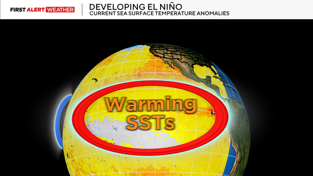
El Niño is just a phase or part of ENSO, the El Niño-Southern Oscillation. It is an interannual mode of climate variability with three phases: neutral, warm (El Niño), or cool (La Niña). By far, ENSO has the greatest influence on weather patterns across the globe.
ENSO is a natural part of Earth’s climate system that exhibits variability over the span of a few years. To determine the current phase of ENSO and how that phase may or may not change, we look at sea surface temperature anomalies over the Equatorial Pacific Ocean and what is occurring underneath the surface by up to several hundred meters.
Right now, we are currently in the neutral phase of ENSO and are projected to head toward a strong warm phase or El Niño by mid-late summer that will last into the fall and upcoming winter.
What initiates and causes the shift?
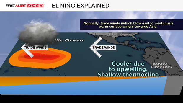
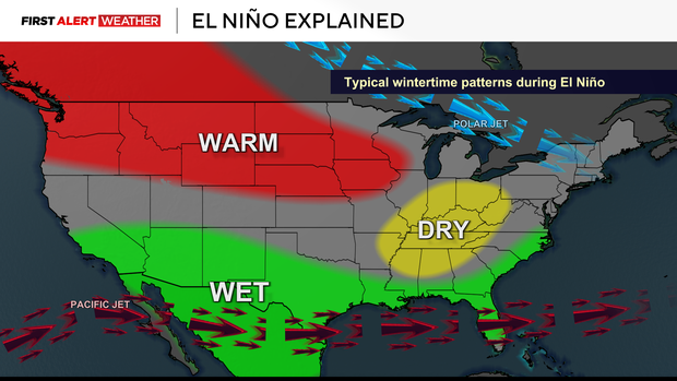
Let’s start with the Walker Circulation, which is the physical mechanism that initiates and influences where warmer and cooler than normal seawater resides near the Equatorial Pacific Ocean.
In the neutral phase of ENSO, the warmer sea surface temperatures are west of the International Date Line near Indonesia while cooler sea surface temperatures are positioned west of coastal South America. Above the warmer waters, we see enhanced rising motion leading to increased thunderstorms in the western Equatorial Pacific Ocean. While air rises and diverges in the upper atmosphere over the western Equatorial Pacific Ocean, it then converges and sinks over the eastern Equatorial Pacific Ocean. This sinking motion diverges at the ocean surface and helps enhance the trade winds which blow from east to west.
The east-to-west trade winds are responsible for upwelling and maintaining the cooler waters near the Equatorial East Pacific Ocean. When these trade winds are enhanced, we see a stronger upwelling of cooler water in the Equatorial East Pacific and a piling up of warmer waters and enhanced thunderstorms in the equatorial West Pacific. This is called La Niña.
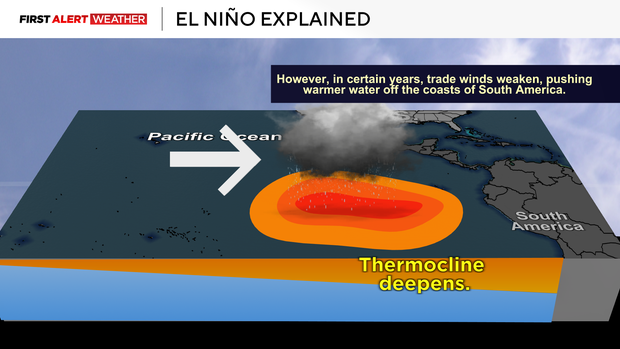
However, when those trade winds weaken, this slows the upwelling process and the warmer sea surface temperatures from the western Pacific Ocean migrate east through enhanced low-level westerly wind bursts. Once the waters in the relative Niño3.4 region— the area monitored in the Equatorial Pacific Ocean to assign the ENSO index — warm to a certain threshold above normal (greater than or equal to +0.5 degrees Celsius) for at least five consecutive overlapping three-month periods, then an El Niño can be declared.
What are the latest trends and projections with this El Niño?
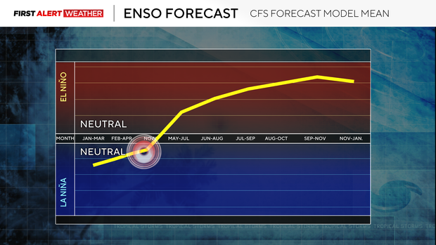
According to NOAA’s Climate Prediction Center, El Niño is likely to emerge between June to August 2026 and persist through the end of the year. El Niño is pretty much expected by the end of year, and it’s likely that we’ll be dealing with a strong or very strong El Niño. The stronger the El Niño or La Niña, the more influence it has on the global weather patterns.
What El Niño means for western Pennsylvania
So how can this year’s setup influence summer patterns, and what does it mean for western Pennsylvania if El Niño persists into the winter?
When answering this question, it is extremely important to note a few things: no two El Niño or La Niña events are exactly alike. There are other factors that influence global weather patterns outside of ENSO, and planetary warming induced by human-caused climate change may cause modern-day El Niño, La Niña, and neutral episodes to behave differently compared to a past climate. We can still look at previous years with similar conditions to get a proxy and make an inference of how the upcoming year may trend.
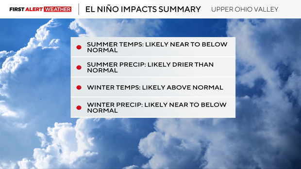
For this year, 2023 is the closest modern-day match under this climate regime to how this El Niño is likely to evolve this summer. For western Pennsylvania, that summer featured near to slightly below normal temperatures and near normal summer precipitation. The following winter featured well above normal temps and slightly above normal precipitation.
1976 is next on my analog years list. This featured a weak to moderate La Niña early in the year, but El Niño emerged more slowly (like 2026 projections) and became very strong by late year. Summer temperatures were below normal with below normal precipitation. That following winter was much drier than normal.
1982 is my third analog year. Unlike 2026, 2023 and 1982, there was no winter to early spring La Niña, but El Niño emerged more slowly (like 2026 projections) and became very strong by late year. During the summer, below normal temperatures were dominant with below normal precipitation. The following winter featured slightly above normal temperatures and below normal precipitation.
1991 and 1997 are also two years on my analog lists. The two commonalities among these years were below normal precipitation during the summer and a drier and warmer than normal following winter as El Niño peaked in intensity.

Leanne Walker said that what quickly came out of thin air and started as a curiosity-grabber turned slightly chaotic.
“People near it didn’t know how to react, with some running away and others running right into it, and some not reacting at all!” said Walker, who captured the dust devil on video. “What struck me most was how fast it was moving and how much debris it picked up.”
At one point, the spout picks up what appears to be a rectangular object, which Walker later discovered was a piece of sheet metal dancing in the dust devil’s swirling winds. Others mentioned seeing cars with minor damage. There were no reported injuries.
Stunned spectators can be heard asking, “Is that dangerous?”
The soccer players played on, and “the referees and players seemed almost completely unfazed,” Walker said.
“The video only captures part of it — the dust devil was actually on the ground for 1–2 minutes in total.“
“Dust devils are pretty common and most occur under calm and sunny conditions,” Globe meteorologist Ken Mahan said, adding that they form when “the high sun angle warms up one part of the ground faster than the surrounding area. Think of a large parking lot surrounded by grass, covered by trees.”
The resulting pockets of air rise rapidly, leaving a low-pressure area in the center, which “pulls in surrounding air that can spiral inward and create a vortex in the right environment,” according to Bryce Williams, a meteorologist with the National Weather Service in Norton. “They are quite common, especially in open, flat areas during the warmer months.”
Most dust devils, he said, usually end up around 50 feet wide or less, but some can double that,” he said, and are on average 500 to 1,000 feet tall. “The winds are exceptionally localized and, while mostly harmless, can get as strong as 70 or 80 mph at times, lasting for a few minutes to about 10 minutes.” But those more powerful winds are rare, especially in the Northeast, Mahan said.
Although most of the time dust devils are more spectacle than threat, Williams said people should still steer clear of one if they do see one nearby.
“Although smaller than tornadoes and forming in a completely different way, dust devils can still be destructive, sometimes lifting debris into the air, creating dangerous projectiles,“ he said.
Mahan said they look dramatic, but they “can’t be warned” because they’re too small to be detected by weather radar. Mahan likened them to the “cousin to the spinning leaf mini-tornadoes we see in the fall.”
“Oftentimes, these remain invisible, but when they pass over a source of dust or dirt, like a ballfield, they become visible,” Williams noted.
It’s safe to say no red card was issued to the dust devil as it tried to stop Sunday’s soccer game.
Carlos Muñoz can be reached at carlos.munoz@globe.com. Follow him @ReadCarlos and on Instagram @Carlosbrknews.
-

 New Jersey4 minutes ago
2 workers airlifted after likely being electrocuted in Ocean City, NJ
-

 New Mexico10 minutes ago
Gila National Forest Hummingbird Fire Update – 4/27/2026
-

 North Carolina16 minutes ago
Projecting North Carolina’s Ceiling in 2026
-

 North Dakota22 minutes ago
ND state representative Liz Conmy dies in Minnesota plane crash
-

 Ohio28 minutes ago
Dr. Katelyn M. Williams, Negley, Ohio
-

 Oklahoma34 minutes ago
Oklahoma judge rules in favor of cannabis farm, lifts suspension
-

 Oregon40 minutes ago
Transfer Guard Jerry Easter II’s Fit in the Oregon Ducks Backcourt
-

 Pennsylvania46 minutes ago
El Niño is likely to form this summer. Here’s what it could mean for western Pennsylvania.