JUNEAU, Alaska (KTUU/Gray News) – A new study highlighted the shrinking Juneau Icefield in southeast Alaska as an example of how Earth’s glaciers are nearing an “irreversible” tipping point for melting.
“If there are processes in Alaska that are accelerating the melt, they may be relevant to other parts of the world as well,” said Bethan Davies, the paper’s lead author, about the global significance of studying Alaska’s glaciers.
The Juneau Icefield is home to dozens of large glaciers — including the popular Mendenhall Glacier in Juneau — and many more smaller ones. By 2100, many of these glaciers are at risk of disappearing. Experts say if the Earth continues to warm, nearly 70% of the world’s roughly 200,000 glaciers will dry up by the end of the century.
The approximately 1,500-square-mile Juneau Icefield blankets the mountains north of Juneau.(U.S. Geological Service)
“When we look at the last 10 years worth of glacier change over all of Alaska, we are seeing a real uptick [in melting] that’s faster than in some other parts of the world,” said Davies, who is also the glaciologist and senior lecturer in Physical Geography at Newcastle University. “And it’s very interesting to ask why that’s happening and why these glaciers are not only accelerating but also how they might behave in the future.”
Advertisement
The study, published this month in the journal Nature Communications, showed from the years 1770 to 1979, ice volume loss remained fairly consistent, at roughly 1 kilometer cubed per year.
From 1979 to 2010, there was slightly more melting, but the loss at 3.1 kilometers cubed per year remained fairly consistent.
However, from 2010 through 2020, the Juneau Icefield’s melting rate doubled to almost 6 kilometers cubed per year. That’s the equivalent of 2.4 million Olympic-size swimming pools melting off of the icefield each year.
The Mendenhall Glacier is one of the dozens of major glaciers that extend out from the Juneau Icefield.(Alaska’s News Source)
That icefield thinning led to the formation of Suicide Basin, which saw its first glacial lake outburst in 2011.
“This can only happen because that whole glacier system, as was pointed out in the study, is thinning,” Alaska climate specialist Rick Thoman said. “It’s thinning a lot and it’s thinning rapidly.”
This water release will happen every year, with some years seeing the potential for historic flooding. But as the glacier keeps thinning, Suicide Basin will reach a point where a glacial lake outburst will no longer form.
Advertisement
However, Thoman says newer basins can form.
“It’s entirely possible given the complex nature of the Juneau Icefield, we might see a new glacier dammed lake form in some other part of the system,” Thoman said. “But as last year showed, when there’s a lot of water in these glacier-dammed lakes, and when they release all the water, we get the devastation that we saw last August.”
All of that melting eventually gets dumped into the ocean. According to Davies, glacier melt accounts for about a quarter of the total sea level rise. The remainder comes from the Antarctic ice, Greenland ice sheet and thermal expansion of the ocean.
“A part of the world that’s contributing the most to sea level rise is Alaska,” Davies said. “The Alaskan glaciers are really important in the global context because there’s a large volume of ice.”
She said this study isn’t relevant to just Alaska, because the same processes occurring here in Alaska may be relevant to other parts of the world.
Advertisement
“What’s happening is that the temperature is gradually increasing,” Davies said. “But as that happens, there’s a series of processes that are accelerating melt or amplifying melt.”
One of those processes is the snow line, which continues to dwindle during the summer months.
Davies said the end of summer snow line is actually reaching the top of the low slope, plateau area. This is historically lower than in previous decades when snow was covering the plateau all year round.
Another challenge is that as more of the plateau is exposed, it’s darkening the mountain as more rocks are exposed from the melting ice.
“When we remove the snow, we are reflecting less of the sun’s energy back into space,” Davies said. “Because snow is very bright and white and reflective. So what we’re doing when we raise that end of summer snow line is we expose much more of the glacier to that darker color so it can absorb more of the sun’s energy.”
Advertisement
Thoman said with the summer snow line dwindling, the atmosphere’s snow level rises with atmospheric rivers aiding in transporting warmer air.
“To hold as much water in the air as those atmospheric rivers bring, the air has to be warm,” Thoman said. “If it was colder it wouldn’t be able to hold as much moisture.”
Thoman said it’s both the high precipitation events and warm airmass that are helping to drive snow levels very high into the atmosphere, which can and do occur all winter long, some years.
Climatologically speaking, Juneau temperatures have warmed a few degrees over the last several decades. And while that may not seem like much, when temperatures are hovering around freezing, that can still have large impacts.
“We’re right around that freezing level,” Thoman said. “So an increase of 31 to 33 [degrees], say, as an average temperature is much more significant when you’re talking about snow and ice than say an increase of 40 to 43.”
Advertisement
Davies doesn’t think the Earth’s ice has passed the point of irreversible change but does argue that such a threshold could occur by the end of this century.
And if the feedback loop of melting continues, the icefield will eventually reach a point where it will be difficult to recover from.
Copyright 2024 KTUU via Gray Local Media, Inc. All rights reserved.
The first Jesuit missionaries in Alaska sailed up the Yukon River in 1887. By the turn of the 20th century, the religious order of the Catholic Church had as many as 50 Jesuits in the state.
Now, only two remain. And by the end of June, there will be none.
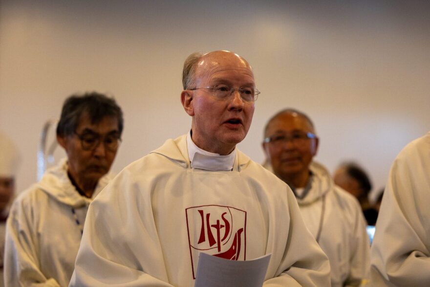
The Jesuits’ nearly 140 years in the state was honored at an event at Bethel’s Immaculate Conception Church on June 16. A procession of priests wearing long white gowns with red hems walked down the aisle to open the event. The Bishop of the Diocese of Fairbanks, Stephen Maekawa, thumped the ground with a shimmering silver staff known as a clozier as he approached the altar.
Bishop of the Diocese of Fairbanks, Steven Maekawa, walks toward the altar at the Immaculate Conception Church in Bethel.
“My brothers and sisters, we gather together to celebrate this wonderful and blessed occasion to acknowledge the love of God and the work of God through the 139 year mission of the Society of Jesus of the Jesuit fathers,” Maekawa said to open the event.
Advertisement
A traditional Catholic mass followed, with readings in both English and Yup’ik. During the sermon, Maekawa acknowledged the vastness of the Fairbanks diocese, and the tremendous amount of work done by the Jesuits to establish it.
“All of the 46 churches of the Diocese of Fairbanks that we currently have were established by either the Jesuit fathers or by direction of a Jesuit bishop,” Maekawa said. “We have a long history of the Society of Jesus’ presence and ministry here in all of Alaska.”
The Jesuits are an order within the Catholic Church, akin to the Dominicans or Franciscans. They have a reputation for taking on some of the Catholic Church’s most remote assignments.
That missionary spirit brought the Jesuits to the Yukon River in 1887, where they built churches, schools, and ministries. Without their work, Catholicism may not have taken root in huge swaths of Alaska, particularly among Alaska Native communities.
The Immaculate Conception Church in Bethel.
But the Jesuits leave a complicated legacy. Their methods of converting Native people to the religion, particularly in the first half of the 20th century, created generational traumas still felt to this day.
Advertisement
Fr. Sean Carroll is the provincial of the Jesuits West Province, which oversees Alaska and nine other states.
Fr. Sean Carroll, provincial of the Jesuits West Province, speaks at an event recognizing nearly 140 years of Jesuit service in Alaska.
“Thank you for all that you have taught us about who Jesus is and how to love and serve Him wholeheartedly,” Carroll said. “I also thank you for your patience with us. For there have been times when we have sinned and when we have hurt you.”
Missionaries, including the Jesuits, forcefully converted and assimilated Alaska Native people into Western culture and religion. Students at Jesuit-run boarding schools were forced to abandon their Native languages and physically punished when caught speaking languages other than English. Native dancing and drumming were also banned.
The Jesuits West Province maintains a list of 150 Jesuits with credible claims of sexual abuse against minors or vulnerable adults. A quarter of the accused Jesuits served in Alaska at some point in time.
“I ask for your forgiveness for all that we have done that was not rooted in Christ and love for Him, and for when we did not value your culture nor recognize the presence of God in you,” Carroll said.
Advertisement
Carroll gave the order to withdraw from the state last spring. A big issue was the recruitment of Jesuits willing to travel and serve in remote villages. He told the congregation that the Jesuits’ work would continue, just without a permanent presence.
Fr. Rich Magner, one of the two remaining Jesuit priests in Alaska, attends a ceremony in Bethel.
Fr. Rich Magner is one of the two remaining Jesuit priests in Alaska. His last day serving Chevak, Hooper Bay, and Scammon Bay is June 30.
“We all always knew coming in, or should have known, that we’re not going to be here forever. It’s going to be mission accomplished at some point,” Magner said. “And then we hand it off to the diocese that we’ve helped create, and so that’s a good feeling.”
Magner’s next stop is a Clinical Pastoral Education residency in Tacoma, Washington.
The other remaining priest, Fr. Tom Provinsal, first came to Alaska in 1968 to teach. A fond memory, he said, was meeting Elders that practiced traditional subsistence lifestyles.
Advertisement
“Some of the grandmothers, their fingers were just all bent with arthritis and stuff like that, you know, their whole lives they’ve been working out in the cold and the wet, doing food, sewing, all that kind of stuff,” Provinsal said. “I’d say I just feel very privileged to have come when I did come and to see that.”
Provinsal returned in 1975 as a priest and has served in the region ever since. After moving away, he plans to take a five month sabbatical. What happens next, he said, is in God’s hands.
Two lines formed in the aisle for communion at the end of the mass. After taking communion, Bethel’s Parish Administrator Susan Murphy gave a final thank you.
“It’s difficult to say goodbye to people who have been a part of our lives for so long,” Murphy said. “We know that you have done what was yours to do, and have taught us to do what is ours to do. We are grateful.”
Jesuit priests form a row along the altar of Bethel’s Immaculate Conception Church as members of the congregation lift their arms and pray.
Dominic Hunt, a Yup’ik deacon that flew in from Emmonak for the event, led the congregation through a final prayer.
Advertisement
“Bless them with your wisdom, that they may be a word of hope, a world in need. We ask this through Christ, our Lord. Amen,” Hunt said.
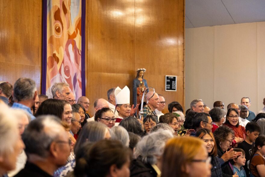
About 70 people posed for a photo on the altar – priests, deacons, parishioners, Elders and children — many of them smiling, some standing quietly.
The photo doesn’t tell the whole story. But it’s a moment when gratitude, grief, and memory all shared the same room.
Bishop of the Diocese of Fairbanks, Steven Maekawa, stands in the middle of a crowd waiting to take a photo at Bethel’s Immaculate Conception Church.
JUNEAU, Alaska (KTUU) – The Supreme Court of Alaska will be taking up the case of the State of Alaska, Division of Elections v. Daniel J. Sullivan, Jr.
The oral arguments will be held Monday at 10 a.m. via Zoom, according to an order and opening notice.
The document also specifies that a decision is expected to be made before noon on Tuesday.
According to documents from the Division of Elections, the state must start printing ballots at noon on the same day.
Advertisement
This comes after an Anchorage Superior Court Judge ordered Dan J. Sullivan on to the ballot Friday.
See a spelling or grammar error? Report it to web@ktuu.com