Hawaii
Lori Dengler | A quick trip to Hawaii and a reminder that tsunamis can be deadly business

I spent last week in Hawaii. Before you get too jealous, it was a work trip, and I never got my feet wet. It was an excellent, informative and sobering trip and not entirely devoid of pleasure.
I have been part of the National Oceanographic and Atmospheric Administration’s (NOAA) Tsunami Science & Technology Advisory Panel (TSTAP) for nearly two years. One can’t write about NOAA without acronyms, so please bear with me. In 1997, NOAA established a Science Advisory Board (SAB) with a responsibility to provide advice in the areas of research, education, resource management, and ocean hazards.
The Science Advisory Board is composed of experts outside of the NOAA organization — from academia, industry, and other government organizations. The SAB currently has five Working Groups — on Climate, Data Management, Ecosystems, Environmental Information, and Tsunamis.
Our tsunami group is small — eight voting members plus NOAA and USGS liaisons. Our focus is the end-to-end tsunami alerting system. That means we look at all aspects from detection of the tsunami source to analysis, dissemination, partners’ response and how everyone in harm’s way reacts. We listen to experts talk about modeling, new detection and analysis systems, social scientists who study messaging and evacuation behaviors, and everything in between. We don’t have money to dole out but report our findings on gaps, weaknesses, and strengths directly to NOAA.
Most of our meetings are remote and online but once a year we meet in person. Last year we convened at NOAA’s Pacific Marine Environmental Laboratory where the tsunami research program is housed. This year was Hawaii with visits to the Pacific Tsunami Warning Center (PTWC), the Hawaii emergency management group, tsunami scientists at the University of Hawaii, and other organizations with tsunami responsibilities.
On Monday before our formal meetings started, I did a day trip to Hilo with Rocky Lopes, another TSTAP member and someone I have worked with for decades. I first met Rocky when he headed the Red Cross preparedness program. His research on what motivates people to take preparedness actions has always been a pillar of our outreach efforts on the North Coast. Fear is a poor motivator, give people the how-tos in a clear and positive way.
We were met in Hilo by two more long-time colleagues, Cindi Preller and Walter Dudley. Cindi is the director of the Pacific Tsunami Museum who I met decades ago in her various roles in NOAA’s tsunami program. Walt was a founder and now board president and scientific advisor to the museum.
The Pacific Tsunami Museum was founded in 1994 with the aim of preserving memories of past tsunamis. At the time, many of the survivors of the 1946 and 1960 tsunamis were aging and their recollections of what happened were in danger of being lost forever.
At first glance, preserving memories might seem like a thin premise on which to build a museum. Personal stories are more important than you might think. They provide evidence as to what happened in past tsunamis and fill out important details that water height measurements can’t depict. We learn about sideways surges and how the tsunami traveled over complex terrain. We also learn the human side — what triggered people to take action and what they did — critical data about evacuation behavior.
Stories are one of the most effective education tools for tsunami awareness and preparedness. Most of the accounts the museum highlights are from ordinary people, including children to the elderly. These stories bring immediacy to the moment and convey that it doesn’t take superhuman efforts or special skills to be a survivor. Knowledge and taking quick action are key.
In the 30 years since its founding, the museum has gone far beyond the original scope. It features exhibits on Hawaii’s tsunami hazards and what areas are at risk. It has become a hub for community outreach programs and training the next generation in not only safety precautions but how to become spokespeople themselves.
Field trips are central to the museum’s activities and Walt gave us an abbreviated version. One only has to step out the front door for sites of what happened in 1946 and 1960, the deadliest and third deadliest tsunamis in U.S. history. Walt has loaded images on a tablet and at each field trip spot can compare the view of today to what it was like in the immediate aftermath of a tsunami.
The most memorable stop was Laupahoehoe Point, about a 40-minute drive north of Hilo. In 1946, it was the site of a small fishing village and a school. The teachers lived in cabins in front of the school adjacent to the coast. Children were beginning to arrive on the morning of April 1, 1946, when a series of surges quickly overtook the school. There was no tsunami warning system at the time and the earthquake that caused the tsunami was in the Aleutians, too far away for anyone to feel.
When the seas finally subsided, 24 students and staff of the school had perished. All of the Hawaiian Islands suffered damage. Hawaii was the hardest hit with 96 deaths. The final toll in the Hawaiian Islands was 159, the highest domestic tsunami casualty number in U.S. history.
Standing where the school once stood brings meaning to those statistics. There is a stone memorial with the names of the victims. Interpretive signs include their photographs and pictures of the school grounds before and after. Laupahoehoe brings focus to our TSTAP efforts. In 1946, seismographs detected the earthquake within minutes of its occurrence. But there was no system to rapidly determine size and location, analyze if it posed a tsunami threat, or send messages to those staff and students at the school before waves arrived. And had a message been sent, would it have been understood?
We spent the rest of the week in meetings with Pacific Tsunami Warning Center personnel, and other agency representatives with response and research responsibilities. A tsunami tragedy at Laupahoehoe won’t be repeated as the school has been moved to high ground. But there are far more people living, working, and vacationing in harm’s way today than in 1946 and even with a timely warning, getting everyone to safe ground is a daunting task. The ghosts of Laupahoehoe are in my dreams and scream that we better figure out how to do so.
Note: See https://tsunami.org/qrcodes/laupahoehoe/ for more on what happened at Laupahoehoe.
Lori Dengler is an emeritus professor of geology at Cal Poly Humboldt, an expert in tsunami and earthquake hazards. Questions or comments about this column, or want a free copy of the preparedness magazine “Living on Shaky Ground”? Leave a message at 707-826-6019 or email Kamome@humboldt.edu.

Hawaii
Hawaii’s largest solar-plus-storage facility now operational
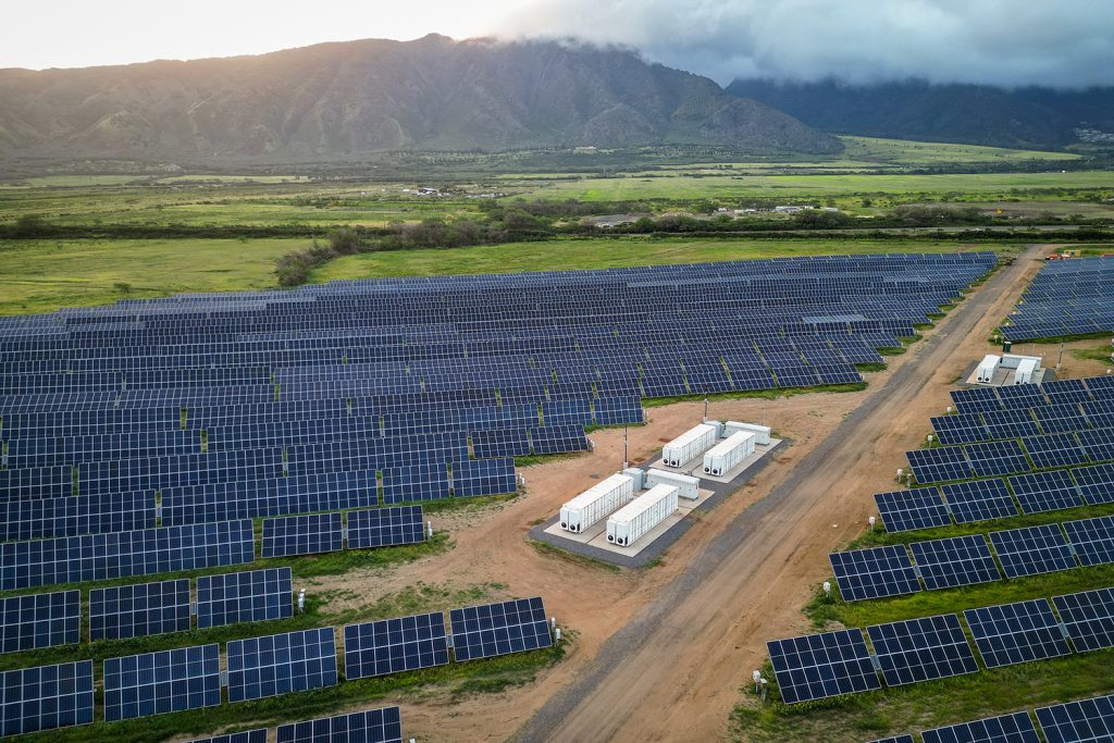
The 60 MW Kūihelani solar-plus-storage facility will generate enough electricity for 27,000 homes, with a 240 MWh battery energy storage system.
From pv magazine USA
Hawaii has the highest average electricity price of any state at $0.43.93 per kWh, nearly triple the U.S. average, yet this project will cut that cost for many residents. Developer AES Hawaii projects that the Kūihelani Solar-plus-Storage facility will generate enough electricity for 15% of Maui’s needs at just $0.08 per kWh.
“Maui residents will soon be seeing the benefit of Kuihelani in their electric bills and the reassurance of knowing they will have reliable electrical power for their homes and businesses,” said Maui Mayor Victorino.
Islands that are not covering their energy needs with renewables are beholden to imported fossil fuels. The energy generated by this facility will offset the need to import an estimated 2 million barrels of oil.
Situated on 450 acres in central Maui, between Kūihelani Highway and Maui Veterans Highway, the project supports the state’s goal of 100% renewable energy and decarbonization targets by 2045. AES Hawaii broke ground for construction less than two years ago, and as with most large-scale solar projects, the company sought input from the community before construction. As a result, AES Hawaii modified its plans.
“We reduced the size of the project site by 35%, minimizing the project’s environmental footprint, while maximizing the usage of the available land in a responsible manner,” said Sandra Larsen, Hawaii market business leader for AES.
Hawaiian Electric is the offtaker of the electricity, having signed a 25-year power purchase agreement with AES Hawaii.
Nearly 300 jobs were supported during the construction of Kūihelani Solar-plus-Storage and generated approximately $68 million for Maui’s economy, according to AES Hawaii. In addition, the project area is also designed for agricultural use.
AES Hawaii has more than 300 MW of renewable energy in construction or operational, enough to power 120,000 homes statewide. The company estimates that this is the equivalent of eliminating more than 175,000 metric tons of carbon emissions and more than 15 million barrels of oil consumption throughout project lifecycles.
This content is protected by copyright and may not be reused. If you want to cooperate with us and would like to reuse some of our content, please contact: editors@pv-magazine.com.
Hawaii
Miss Hawaii U.S. International Melody Higa heading to Florida to compete for the National Crown

We recognize you are attempting to access this website from a country belonging to the European Economic Area (EEA) including the EU which
enforces the General Data Protection Regulation (GDPR) and therefore access cannot be granted at this time.
For any issues, contact news@kitv.com or call 808-535-0400 .
Hawaii
Volcano Watch: A decade later, remembering the Pahoa lava flow crisis
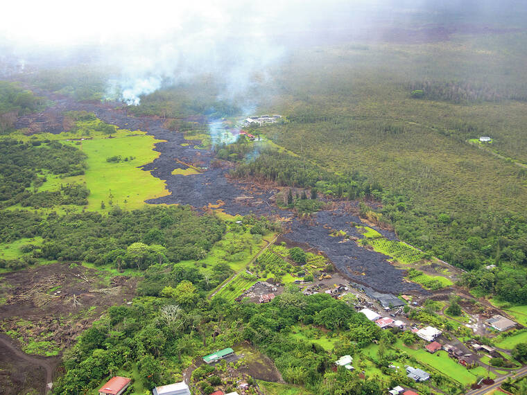
Over the past few years, eruptions of Kilauea volcano on the Island of Hawaii have happened in remote regions and lava flows have not directly threatened communities. However, the approaching anniversary of a lava flow crisis a decade ago reminds us that eruptions on Kilauea have the potential to cause damage and island-wide disruption.
The 2018 lower East Rift Zone eruption of Kilauea is still fresh in many of our minds, but even before then, Kilauea lava flows entering communities was not uncommon. During the 35-year-long eruption of Pu‘u‘o‘o, on the East Rift Zone of Kilauea, lava flows caused destruction in Royal Gardens, Kalapana, and in Pahoa. Before Pu‘u‘o‘o, there were also eruptions in Kapoho Village in 1960 and on Kilauea’s lower East Rift Zone in 1955.
Ten years ago, inflation at Pu‘u‘o‘o in May and June lead to a new eruptive episode on the northeast flank of the cone. It was informally named episode 61e, but more commonly referred to as the June 27 flow in reference to the start date of that episode in 2014.
In the first few days, four fissures produced channelized flows before the eruption focused at the lowest elevation vent, where a perched pond began to form. The pond elevation continued to rise until it was about 30 meters (100 ft) higher than the vent. On July 10, pressure from the perched pond triggered the eruptive vent to shift to the next highest fissure and abandon the perched pond.
The change in eruptive vent produced a fast-moving channelized flow that traveled up to several hundred meters (yards) per day. The flow continued to the northeast until it extended across the eastern edge of the Pu‘u‘o‘o flow field by the beginning of August.
On August 18, the lava entered into a deep ground crack that directed the flow further to the northeast. After about a week the lava overflowed from the crack, before repeating this pattern at three additional and parallel ground cracks. The flow traveled roughly 5 km (3 mi) underground in these cracks to within about 1.2 km (0.7 mi) of Ka‘ohe Homesteads subdivision where the lava exited the final crack in early September.
The flow front advanced slow and steadily during the first few weeks of September, passing Ka‘ohe Homesteads to the northwest. Then from late-September to early-October, the lava flow’s rate of advance began to fluctuate as it stalled and advanced. Towards the end of October, a breakout surged through a narrow drainage and crossed Cemetery Road in Pahoa. The flow continued through the Pahoa Japanese Cemetery, through private property, and destroyed one structure, stalling only 155 m (510 ft) from Pahoa Village Road.
A large breakout on November 14 occurred roughly 6.5 km (4 mi) upslope of the flow front, and rapidly advanced along the northwest margin of the previous flow, ultimately headed towards Pahoa Marketplace and Highway 130. The flow front again stalled on December 30 after advancing to within 530 m (0.3 mi) of the marketplace. That was the furthest the lava flow advanced, but numerous breakouts just upslope continued to threaten Pahoa until early 2015.
Episode 61e, or the June 27 flow, then retreated upslope and stayed within about 8 km (5 mi) of Pu‘u‘o‘o. This episode continued until early June 2016, when inflation at Pu‘u‘o‘o culminated in two new eruptive vents on the northeast (episode 61f) and southeast (episode 61g) flanks of the cone on May 24.
The episode 61f flow was short-lived, lasting less than two weeks. However, the 61g flow remained active until the Pu‘u‘o‘o crater floor collapsed on April 30, 2018, followed by the intrusion of magma into the lower East Rift Zone and subsequent eruption.
Since then, eruptions from Kilauea have fortunately been confined within Kaluapele (Kilauea caldera) or other remote areas of Hawaii Volcanoes National Park. Currently, there are no signs of magma moving into the East Rift Zone but that will inevitably happen again someday. The Pahoa lava flow crisis and other destructive East Rift Zone eruptions are reminders that communities on or near the rift zone are vulnerable. Residents and visitors should stay informed and remember that it’s never too early consider how an eruption could impact you and your family.
Volcano
activity updates
Kilauea is not erupting. Its USGS Volcano Alert level is ADVISORY.
Kilauea erupted briefly on June 3 southwest of Kaluapele (Kilauea caldera) within the closed area of Hawaii Volcanoes National Park. Sulfur dioxide emission rates remain elevated; an emission rate of 350 tonnes per day was measured on June 10, for the combined areas of Kilauea summit and the recent eruption. Seismicity in the summit region, including the upper East Rift Zone, has been slightly elevated with about 550 events over the past week. Inflationary ground deformation has continued in the summit region. Additional pulses of seismicity and deformation could result in new eruptive episodes within the area or elsewhere on the Southwest Rift Zone.
Mauna Loa is not erupting. Its USGS Volcano Alert Level is at NORMAL.
Webcams show no signs of activity on Mauna Loa. Summit seismicity has remained at low levels over the past month. Ground deformation indicates continuing slow inflation as magma replenishes the reservoir system following the 2022 eruption. SO2 emission rates are at background levels.
One earthquake was reported felt in the Hawaiian Islands during the past week: a M3.4 earthquake 14 km (8 mi) S of Volcano at 1 km (1 mi) depth on June 6 at 12:29 p.m. HST.
HVO continues to closely monitor Kilauea and Mauna Loa.
Please visit HVO’s website for past Volcano Watch articles, Kilauea and Mauna Loa updates, volcano photos, maps, recent earthquake information, and more. Email questions to askHVO@usgs.gov.
Volcano Watch is a weekly article and activity update written by U.S. Geological Survey Hawaiian Volcano Observatory scientists and affiliates.
-

 Politics1 week ago
Newson, Dem leaders try to negotiate Prop 47 reform off California ballots, as GOP wants to let voters decide
-

 News1 week ago
Would President Biden’s asylum restrictions work? It’s a short-term fix, analysts say
-

 World1 week ago
Dozens killed near Sudan’s capital as UN warns of soaring displacement
-

 News1 week ago
Read Justice Clarence Thomas’s Financial Disclosures for 2023
-

 World1 week ago
‘Bloody policies’: Bodies of 11 refugees and migrants recovered off Libya
-

 Politics1 week ago
Embattled Biden border order loaded with loopholes 'to drive a truck through': critics
-

 Politics1 week ago
Gun group vows to 'defend' Trump's concealed carry license after conviction
-

 Politics7 days ago
Should Trump have confidence in his lawyers? Legal experts weigh in


