In Washington on Saturday, the atmosphere appeared to acknowledge the heritage of heat bequeathed by Friday, and while the day was cooler, and cloudier, it was still comfortable.
Washington, D.C
After heat record is set here, D.C. was cooler, still comfortable

With a high temperature of 61, it too seemed more springlike than wintry.
It was 16 degrees above the Jan. 27 average, and had it not occurred the day after Friday’s stunning thermal spike, Saturday’s reading might have drawn more attention to its own achievements.
A 61-degree high demonstrated meteorological precocity. It presented Washington with an environmental performance that could be considered to be two full months ahead of its time.
By the figures issued by the National Weather Service, Saturday’s 61-degree high only becomes the average high in D.C. on March 28 and 29.
It is possible, however, that any giddiness or high spirits prompted by the thermometer reading were suppressed somewhat by a sky that for much of Saturday’s daylight hours was largely dominated by gray clouds.
Weather forecasts for Saturday night and for Sunday spoke of rain. Even to the least weather-savvy, Saturday’s skies seemed to endorse that likelihood. They suggested that rain could come as no great surprise.
Dark gray clouds made their way across a background composed of clouds of a lighter gray, at higher elevations. A rotundity displayed by some of them hinted at the quantities of water droplets they might be preparing to unleash.
Although the day did not seem particularly humid, neither did it offer the sense of midwinter crispness. If not a notably damp day it gave a sense of verging on dampness.
And perhaps the stillness of the air, the lack of any wind to speak of, contributed to a suspicion of what was to come.
It helped to convey the feeling that the city might be experiencing a period of slightly moist calm before the arrival of the proverbial and predicted rainstorm.


Washington, D.C
Nonprofit sues the federal government over plans to paint Lincoln Memorial Reflecting Pool blue

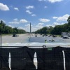
With a blue sky above the Lincoln Memorial, people walk along the reflection pool in Washington, D.C., on June 9, 2023.
Jose Luis Magana/AP
hide caption
toggle caption
Jose Luis Magana/AP
A nonprofit is suing the National Park Service, the Department of the Interior and Interior Secretary Doug Burgum over the decision to resurface the Lincoln Memorial Reflecting Pool at Washington D.C.’s National Mall, and to paint the pool’s basin blue.
The suit was filed Monday in U.S. District Court for the District of Columbia by The Cultural Landscape Foundation (TCLF), an education and advocacy organization. In the suit, TCLF is asking a federal judge to halt the project, saying that the Trump administration failed to have the project reviewed federally, as is dictated by the National Historic Preservation Act.
President Trump revealed his plans for the pool do-over last month in “American flag blue,” saying that the project would take one week and $2 million, and that it would be completed in time for the 250th anniversary of the Declaration of Independence on July 4. A few days later on Truth Social, the president posted a fake image of himself and several of his administration officials in swimsuits, along with an unidentified woman in a gingham bikini, lounging in the water with the Washington National Monument at the rear. (Swimming in the reflecting pool is prohibited by federal law.)
In a YouTube video posted by the White House on April 23, Trump called the pool “filthy dirty” and said it “leaked like a sieve.” In that video, Trump said he was going to call three companies that he has worked with in the past – “all they do is swimming pools” – and say, “Give me a good price.”
The New York Times reported last Friday that the contract for the reflecting pool’s resurfacing was awarded in a $6.9 million no-bid contract to a company called Atlantic Industrial Coatings, which previously has never held any federal contracts.
An employee at the Atlantic Industrial Coatings confirmed in a telephone call on Monday that it has been contracted for this project, but referred all other questions to the Department of the Interior.
The Times reported on Monday that the final cost of the project could be upward of $13 million, per documents it says it has obtained. The Department of the Interior did not confirm the cost of the project, but wrote: “The contract price reflects the effort necessary to expedite the timeline of completing the leak prevention coating project—more people, more materials, more equipment and longer hours ahead of our 250th.”
In an unsigned statement emailed to NPR Monday afternoon, the Interior Department wrote: “The National Park Service chose the best company to expedite the repair of the iconic Reflecting Pool ahead of our 250 celebrations. The choice of American Flag Blue will enhance the visitor experience by making the pool reflect the grand Lincoln Memorial and Washington Monument. NPS is also investing in a state-of-the-art ozone nanobubbler filtration system and will now have a dedicated crew who will maintain the grounds’ from wildlife. The Department is proud of the work being carried out by our Park Service to ensure this magical spot can be enjoyed for not only our 250th, but for many generations to come.”
Critics of the project, including TCLF, don’t share that vision – and are taking particular umbrage at the color.
“The reflecting pool should not be viewed in isolation; it is part of the larger ensemble of designed landscapes that comprise the National Mall,” Charles A. Birnbaum, the president and CEO of TCLF, said in a statement emailed to NPR Monday. “The design intent, to create a reflective surface that is subordinate, is fundamental to the solemn and hallowed visual and spatial connection between the Washington Monument and the Lincoln Memorial. A blue-tinted basin is more appropriate to a resort or theme park.”
The National Park Service regularly cleans out algae, goose droppings and other detritus from the reflecting pool. The last major renovation of the reflecting pool, which included the installation of a new circulation and filtration system, took place during the Obama administration at a reported cost of $34 million.
Before founding TCLF in 2008, Birnbaum served for 15 years as the coordinator of the Historic Landscape Initiative for the National Park Service.

TCLF has another open lawsuit against the federal administration: it is one of eight cultural and architecture groups currently suing President Trump and the Kennedy Center board over the planned renovations of the complex, which are planned to start in July.

The memorial service will be held at the National Law Enforcement Officers Memorial at 1 p.m.
WASHINGTON D.C. – A brave K-9 hero from the region will be honored at the Annual National Police K9 Memorial Service on Monday afternoon.
K-9 Knox died in the line of duty last year after he was accidentally hit by a police vehicle while pursuing a suspect involved in a stolen vehicle incident. He was a 3-year-old German shepherd and had served as a narcotics detection and patrol apprehension K-9 for the Roanoke Police Department since May 2023.
The memorial service will include a wreath-laying ceremony and will be held at the National Law Enforcement Officers Memorial in Washington, D.C., at 1 p.m. The event will open with a musical performance by Frank Ray, and the guest speaker will be Deputy Jared Hahn of the Miami-Dade Sheriff’s Office K-9 Unit.
The San Antonio Police Department Blue Line Choir will sing the national anthem, and the Emerald Society Pipes & Drums band will also perform.
Copyright 2026 by WSLS 10 – All rights reserved.

4 things to know about the weather:
- Shower chance Monday morning
- Cooler Monday
- Midweek rain chance
- Warmer end to the week
Showers continue to move west with a cold front tonight. There will be a break in the rain overnight, but showers return for the start of the day on Monday. Monday afternoon will be dry, but noticeably cooler.
Sunshine returns Tuesday, but the break in the rain will be short-lived with rain chances on Wednesday
Download the NBC Washington app on iOS and Android to check the weather radar on the go.
QuickCast
TONIGHT:
Showers early
Mostly cloudy
Wind: N 5-10 mph
LOW: Low 50s
MONDAY:
Morning shower chance
Wind: N 5-10 mph
HIGH: Upper 60s
TUESDAY:
Sunny
Wind: N 5-10 mph
HIGH: Near 70°
WEDNESDAY:
Shower chance
Wind: S 5-10 mph
Gusts at 20 mph
HIGH: Low 70s
SUNRISE: 5:59 a.m. SUNSET: 8:10 p.m.
AVERAGE HIGH: 75° AVERAGE LOW: 56°
Stay with Storm Team4 for the latest forecast. Download the NBC Washington app on iOS and Android to get severe weather alerts on your phone.
-
Dallas, TX2 minutes ago
Former Cowboys QB Craig Morton passes away at age 83
-

 Miami, FL8 minutes ago
Brickell Avenue Bridge openings spark rush hour gridlock concerns in downtown Miami
-

 Boston, MA14 minutes ago
What we know about accused Memorial Drive gunman Tyler Brown
-

 Denver, CO20 minutes ago
Broncos Ring of Famer Craig Morton, who led Denver to first Super Bowl, dies at 83
-

 Seattle, WA26 minutes ago
Victim identified in deadly Seattle beer garden shooting on Lake City Way; suspect sought
-
 San Diego, CA32 minutes ago
San Diego health officials monitor hantavirus situation as cruise ship passengers return to U.S.
-

 Milwaukee, WI38 minutes ago
Same name keeps coming up in mock drafts as possible Bucks selection
-

 Atlanta, GA44 minutes ago
Fire at Chamblee apartment complex displaces more than 75 residents, closes businesses