Wyoming
More Rain, Snow In Southeast Wyoming Weather Forecast

Two more cold fronts are expected to pass through southeast Wyoming over the next couple of days, bringing more wet weather with them.
That’s according to the Cheyenne Office of the National Weather Service. The agency posted the following on its website:
Greetings! Looks like the next three days across southeast Wyoming and Nebraska Panhandle will stay unsettled weather-wise as we still have two more cold fronts set to move through the area. First one tomorrow, that will move in from the west. Look for increasing chances for morning showers from west to east with afternoon rumbles of thunderstorms. Second cold front, the stronger of the two, moves through Friday. This front expected to bring fairly widespread showers and thunderstorms from west to east. The good news? The weekend still looks warmer and drier as we get treated to high pressure. Hold on a few more days, nicer weather is coming! Besides, we need the moisture!
Cheyenne and Laramie Forecast
Cheyenne Forecast
Today
Scattered showers, then showers likely and possibly a thunderstorm after 3pm. Mostly cloudy, with a steady temperature around 55. South southwest wind around 15 mph becoming west northwest in the afternoon. Chance of precipitation is 60%. New rainfall amounts of less than a tenth of an inch, except higher amounts possible in thunderstorms.
Tonight
Scattered rain showers before 11pm, then scattered rain and snow showers between 11pm and midnight, then a slight chance of snow showers after midnight. Some thunder is also possible. Cloudy during the early evening, then gradual clearing, with a low around 31. Northwest wind around 15 mph. Chance of precipitation is 50%.
Thursday
A slight chance of snow showers before 2pm, then a slight chance of rain and snow showers between 2pm and 3pm, then a slight chance of rain showers after 3pm. Sunny, with a high near 54. Breezy, with a west wind 15 to 25 mph, with gusts as high as 35 mph. Chance of precipitation is 20%.
Thursday Night
A chance of rain and snow showers, mainly after midnight. Mostly cloudy, with a low around 32. Breezy, with a west wind 15 to 20 mph becoming southwest 5 to 10 mph after midnight. Winds could gust as high as 30 mph. Chance of precipitation is 40%.
Friday
A slight chance of rain and snow showers before 9am, then rain showers likely. Some thunder is also possible. Partly sunny, with a high near 56. South wind 5 to 15 mph becoming north northwest in the afternoon. Chance of precipitation is 60%.
Friday Night
A chance of showers and thunderstorms before 9pm, then a chance of showers between 9pm and midnight. Partly cloudy, with a low around 27. Blustery. Chance of precipitation is 30%.
Saturday
Sunny, with a high near 61. Breezy.
Saturday Night
Partly cloudy, with a low around 39. Breezy.
Sunday
Mostly sunny, with a high near 73. Breezy.
Sunday Night
A chance of showers. Mostly cloudy, with a low around 41. Breezy.
Monday
A chance of showers. Partly sunny, with a high near 63. Breezy.
Monday Night
A slight chance of showers. Partly cloudy, with a low around 38. Breezy.
Tuesday
A slight chance of showers. Mostly sunny, with a high near 64. Breezy.
Laramie Forecast
This Afternoon
Scattered showers and thunderstorms, then showers likely and possibly a thunderstorm after 3pm. Mostly cloudy, with a high near 51. West wind around 15 mph. Chance of precipitation is 60%. New rainfall amounts of less than a tenth of an inch, except higher amounts possible in thunderstorms.
Tonight
Scattered rain and snow showers before 9pm, then scattered snow showers between 9pm and midnight. Some thunder is also possible. Mostly cloudy, then gradually becoming mostly clear, with a low around 25. West northwest wind 10 to 15 mph. Chance of precipitation is 50%.
Thursday
A 20 percent chance of snow showers after noon. Mostly sunny, with a high near 48. Breezy, with a west wind 15 to 20 mph increasing to 20 to 25 mph in the afternoon. Winds could gust as high as 40 mph.
Thursday Night
A 20 percent chance of snow showers. Mostly cloudy, with a low around 28. Breezy, with a west wind 15 to 20 mph becoming south 5 to 10 mph in the evening. Winds could gust as high as 35 mph.
Friday
Scattered snow showers before 11am, then rain and snow showers likely. Some thunder is also possible. Partly sunny, with a high near 50. South wind 5 to 15 mph becoming west northwest in the afternoon. Chance of precipitation is 60%.
Friday Night
A slight chance of rain and snow showers before 8pm, then a slight chance of snow showers between 8pm and midnight. Some thunder is also possible. Mostly clear, with a low around 26. Blustery. Chance of precipitation is 20%.
Saturday
Sunny, with a high near 61.
Saturday Night
Partly cloudy, with a low around 38.
Sunday
Mostly sunny, with a high near 69.
Sunday Night
A chance of rain showers before 5am, then a chance of rain and snow showers. Mostly cloudy, with a low around 38.
Monday
A chance of rain and snow showers. Partly sunny, with a high near 57. Breezy.
Monday Night
A slight chance of rain and snow showers. Partly cloudy, with a low around 34. Breezy.
Tuesday
A slight chance of showers. Mostly sunny, with a high near 57. Breezy.
Wyoming Cowboys Football: 2023 Season in Photos
Our 7220sports.com photographer DJ Johnson is on the sideline at every Wyoming football game. Rain, shine — and everything in between — you’re likely to find him scouring stadiums around the country looking for “the shot.” Take a look at some of DJ’s highlights during the 2023 campaign.
Gallery Credit: DJ Johnson photos

Wyoming
Wyoming’s New Signal Caller Shows Off Wheels in First Spring Practice
LARAMIE — What time is it?
Jay Sawvel looked at his watch-less left wrist Tuesday evening before peering to his right at the wall inside Wyoming’s team meeting room. There, two digital clocks — with two different times — glared in red.
“We got two clocks in this building because one of them never keeps the time the right way,” the third-year head coach joked before getting back to his original point.
“By 6:30 or 6:45, he’s probably back upstairs watching everything from practice today,” Sawvel said at 5:48 … or 5:53, whichever clock you want to trust. “That’s first and foremost what you really like to see.”
He’s referring to quarterback Tyler Hughes, who just completed his first practice in a Cowboy uniform.
The graduate transfer from William and Mary was on target in the passing game the majority of the afternoon, sharing reps with Gillette’s Mason Drube. Where he really raised eyebrows, though, was on a broken play midway through the 20-period workout inside War Memorial Stadium.
The 6-foot, 210-pound Georgia native eluded the oncoming pass rush and stepped up in the pocket before tucking the ball under his right arm and bolting right down the middle of the field.
Sure, you aren’t supposed to tackle the signal caller in this scenario under any circumstances, but Sawvel still thought he had a chance to go the distance either way.
“I told (defensive coordinator) Aaron Bohl that on one of the plays today, we did lose contain, and the next thing you know, it would have been a 35-yard play because we were in man coverage. A bunch of guys had their backs turned,” he said with a smile and a slight head shake. “It’s going to be hard to play a lot of man against Tyler Hughes — and even Mason — but especially with Tyler.
“That guy can roll. If you lose a rush lane, you’re now at risk, because really, on any given play, he might be the fastest guy on the field.”
MORE UW FOOTBALL NEWS VIA 7220SPORTS:
* Wyoming Football: Good, Bad and Ugly from 2025
* Sawvel Seeking Consistency From Kicking, Punting Operation
* Is There Really an Open QB Competition in Laramie?
* Jack Dunkley is ‘Mentally Wired’ to do Damage of the Edge
* 5 Things I’ll Be Watching During UW Spring Football
* Evan Eller Has Reaper the Benefits of Self-Imposed Redshirt
* The ‘Governor’ Will Not Be Seeking Re-Election
* Former UW Safety Andrew Wingard Inks 1-Year Deal With Arizona
* UW Athletics, Cowboy Joe Club Launch ‘Step Forward’ Campaign
* Former Three-Star Lineman Getting Early Jump on Process
* New Wyoming Wideout Eager to Prove Himself at FBS Level
* Former CSU Safety Inks With Border War Rival Wyoming
Hughes was the first QB in William and Mary’s program history to throw for more than 2,300 yards and rush for an additional 650 in a single season. He also tossed 20 touchdowns and found the end zone 11 more times on the ground.
Wyoming’s starting quarterbacks in 2025 combined for 79 yards on 74 rushing attempts. Kaden Anderson, who started all 12 games, finished with minus-39 on the ground on 43 of those rushes. He was also sacked 14 times to the tune of 119 lost yards.
Anderson entered the transfer portal and is now at Tarleton State.
Hughes brings an entirely different element to this offense.
“That dude can move,” left tackle Rex Johnsen said Tuesday, adding that Hughes’ mobility could also lead to way less damage behind the line of scrimmage. “I’m excited to watch him take off down the sideline.”
Sawvel has said multiple times this offseason he can’t get Hughes to leave the building. Though he couldn’t watch himself — believe it or not, the NCAA still has a rule or two — the head man saw the lights on inside the stadium late one Friday night.
It was a handful of receivers, running routes for Hughes.
“He’s really professional,” wideout Eric Richardson said on Tuesday as he walked toward Jonah Field. “Before our walkthrough today, he was in the film room for an hour. Guy is dedicated.”
Sawvel said he liked the way the ball came out of Hughes’ hand in his first practice, which included some breezy conditions. He liked his movement in the pocket. Mainly, though, he praised his presence.
“I’m glad he’s here,” he said with a smile.
(Have you downloaded our free app? You can do that right here. Have you signed up for our daily newsletter? We got you covered right here. Questions, concerns? Shoot us an email at cody@7220sports.com)
University of Wyoming’s Top 50 Football Players
The rules are simple: What was the player’s impact while in Laramie? That means NFL stats, draft status or any other accolade earned outside of UW is irrelevant when it comes to this list.
This isn’t a one-man job. This task called for a panel of experts. Joining 7220’s Cody Tucker are Robert Gagliardi, Jared Newland, Ryan Thorburn, and Kevin McKinney.
We all compiled our own list of 50 and let computer averages do the work. Think BCS — only we hope this catalog is fairer.
Gallery Credit: 7220Sports.com
– University of Wyoming’s Top 50 Football Players
Wyoming
WGFD finds live zebra mussels on boat from Oklahoma at AIS checkpoint

Wyoming
How Wyoming Game Wardens Cracked The Cody Serial Poaching Case

For four straight nights, Game Warden Spencer Carstens and a fellow officer sat in an unmarked vehicle at a Cody city park, windows down, staring into the blackness from dusk until 3 a.m.
Nothing happened.
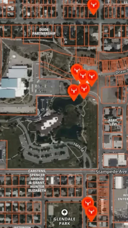
The poaching caper that would become known internally as the “Cody Park Case” had been building since late August 2024, when residents began finding mule deer carcasses in their front yards and floating in a pond at the Park County Complex. The deer body count reached nine.
According to Wyoming Game and Fish, all nine were killed “right in the middle of town where deer like to hang out” by the library, not far from Canal Park and Glendale Park
All shot with a compound bow, all left to rot.
By the time wardens launched their stakeout, and the only lead was grainy security camera footage of a silver car cruising the neighborhood.
The full story of how the case came together is now the subject of an episode of the Wyoming Wildlife Podcast, hosted by Robert Gagliardi, the assistant editor of Wyoming Wildlife magazine. The podcast is a newer offering from the Wyoming Game and Fish Department, and this particular episode stood out for good reason.
“Our law enforcement stories, those are a fan favorite because they’re very exciting, they’re incredibly interesting, and they do a great job just highlighting just how much work goes into successfully investigating and closing a case like that,” Amanda Fry, public information officer for Wyoming Game and Fish, told Cowboy State Daily.
First Blood
In 2024, the first dead buck appeared in someone’s front yard near a city park, with a blood trail leading across the street and footprints disappearing into the grass. An arrow wound made the cause of death obvious.
“The first thing I kind of thought of was maybe it was a kid,” Carstens recalled for the podcast. A deer in a backyard, shot for fun — that was going to be the end of it.
But then, more reports came in the same day. A second buck, a couple of doors down, also arrowed.
Then a third, in a nearby park, where wardens recovered an arrow — an expandable broadhead fired from a compound bow, a typical hunting setup. Then deer four, five and six. Then number seven, found floating in a pond at the Park County Complex, requiring Carstens to wade out in chest waders to retrieve it.
All nine carcasses — two bucks, six does and a fawn — turned up within a tight radius around the county library and city park, right in the middle of town.
Every animal was shot and abandoned. None were harvested in any way.
“They were just killed and left,” Fry confirmed.
Silver Car
Being in city limits gave wardens tools they rarely get to use. Ring doorbell cameras from cooperative neighbors produced footage of activity on the nights deer were killed. Security cameras at a local business captured a silver car driving slowly up and down the street before parking, and a figure stepping out with a flashlight.
It was the first real break, but the footage was too grainy to identify a make and model, let alone a license plate.
“And of course, it’s one of those deals where there’s just silver cars everywhere you look, once you start looking for them,” Carstens said.
An early lead pointed to a group of teenagers spotted on Ring camera footage running around and riding in the back of a truck. Wardens tracked them down at a local school — only to learn they had been playing a supervised game that night, organized by Cody police. They were ruled out.
With no suspect and deer still turning up dead, Carstens and his team decided to stake out the park. They would sit in the dark and wait.

Fifth Night
By the fifth night of the stakeout, the wardens were running on fumes.
“We’re kind of tired, kind of getting sick of it, trying to figure out what are we going to do next because this isn’t working,” Carstens recalled.
Then they heard it — the unmistakable thwack of a compound bow firing in the darkness, followed by the sound of an arrow hitting flesh.
Using night vision, the wardens looked out into the park. A man was standing there holding a bow, standing over a dead deer.
Carstens crept out of the truck and got as close as he could before making contact. The man bolted.
“I actually get in a foot pursuit with this guy,” Carstens said. “He was a young, pretty fast guy, so he got away from me.”
But the suspect had to have driven there. Wardens fanned out and found the silver car parked about a block away. Peering through the window, they saw an arrow lying on the front seat that matched the one recovered from an earlier crime scene.
And the car was full of fresh groceries.
“Basically went out to get groceries, on his way home decided to pull over and shoot a deer in the park,” Carstens said.

Blood Science
The suspect — later identified as Joshua Tamirat Wielhouwer — fled the state. But wardens had his vehicle and, soon, search warrants for the house where he had been staying. Inside, archery equipment was scattered through multiple rooms. A second vehicle yielded more gear, including a bow and broadheads.
Some of that equipment had blood on it. In some cases, only minuscule traces.
Wardens had also been collecting the deer carcasses and storing them in an evidence freezer. They sent tissue samples from eight of the nine deer to the Wyoming Game & Fish forensics lab, along with every piece of blood-stained archery equipment from the house.
What came back was, in Carstens’ word, “remarkable.”
The lab matched all eight deer to specific pieces of equipment — individual broadheads, arrows and metal inserts — through DNA analysis. Trace amounts of tissue inside a tiny metal arrow insert were enough to tie a specific deer to a specific arrow.
“This is the first case that I’ve worked where we’ve actually been able to take nothing but DNA evidence and make a full case on it,” Carstens said. “Big kudos to the forensics lab. They really helped put this case together. We wouldn’t have a case without them.”
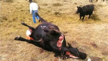
A cell phone search warrant then connected the suspect’s archery equipment to an older case — a beef cow shot with multiple arrows and left to die the year before, a case the Park County Sheriff’s Office had been unable to solve.

Serial Poacher
With a nationwide extraditable warrant issued through the Park County prosecuting office, officers in another state began looking for the suspect. He eventually turned himself in, flew back to Cody and sat in jail for 75 days before posting bail.
A trial was set for February 2025. Before it began, prosecutors and the defense reached a plea deal: guilty on nine of the 18 misdemeanor charges, $18,000 in restitution for the deer and one full year in county jail, with 73 days credited for time served.
The suspect also pleaded guilty to felony destruction of property for the cow, paying restitution to the rancher and accepting three years of supervised probation. All seized archery equipment was forfeited.
A year behind bars is an unusual outcome for a wildlife case in Wyoming, where penalties more commonly involve fines and revocation of hunting privileges, explained Carstens.
“This guy had never purchased a hunting license in Wyoming,” Carstens said. “He wasn’t really a traditional hunter in the sense that he buys a license, goes out in the field and looks to harvest anything.”
The warden’s best guess at a motive: the suspect was into archery as target shooting and “maybe just wanted to take it to the next level and see what he could do with his bow.”

Team Effort
Carstens credited his fellow wardens and the Game and Fish investigative unit — which considered the dead cow as a possible predator conflict before determining it had been killed by a bow — and the Park County prosecutor’s office.
“This was definitely the most collaborative effort that I’ve been a part of,” Carstens said.
The community played a role too. Neighbors willingly shared security camera footage, and residents who enjoy the town’s urban mule deer herd were eager to see the case resolved.
“Our hope is to cover everything Game and Fish is doing,” Fry said of the Wyoming Wildlife Podcast. “We have terrestrial habitat work, aquatic habitat work, but our law enforcement stories — those are a fan favorite.”
David Madison can be reached at david@cowboystatedaily.com.
-

 Detroit, MI7 days ago
Drummer Brian Pastoria, longtime Detroit music advocate, dies at 68
-

 Georgia1 week ago
How ICE plans for a detention warehouse pushed a Georgia town to fight back | CNN Politics
-

 Movie Reviews6 days ago
‘Youth’ Twitter review: Ken Karunaas impresses audiences; Suraj Venjaramoodu adds charm; music wins praise | – The Times of India
-

 Education1 week ago
Video: Turning Point USA Clubs Expand to High Schools Across America
-

 Sports4 days ago
IOC addresses execution of 19-year-old Iranian wrestler Saleh Mohammadi
-

 Science1 week ago
Industrial chemicals have reached the middle of the oceans, new study shows
-

 Science1 week ago
How a Melting Glacier in Antarctica Could Affect Tens of Millions Around the Globe
-

 Culture1 week ago
Test Your Memory of Great Lines From Classic Irish Poems


