Alaska
Avalanches reported in Turnagain Pass area as avalanche concern is high in part of Southcentral

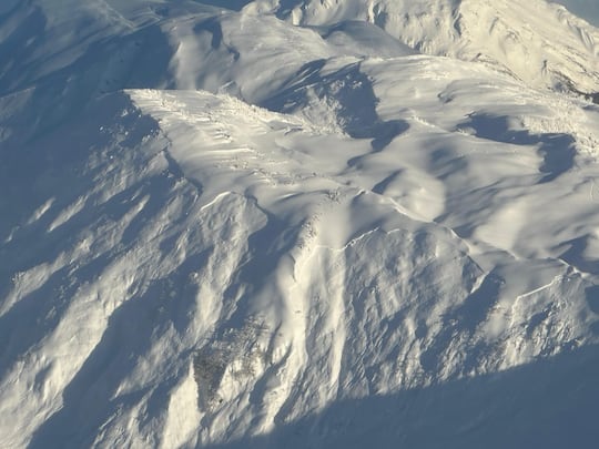
ANCHORAGE, Alaska (KTUU) – Avalanches have been reported in the Turnagain Pass area as avalanche danger Sunday is high in the that area and considerable in the Summit Lake area, according to the Chugach National Forest Avalanche Center.
North American Public Avalanche Danger scale has five levels: low, moderate, considerable, high and extreme.
Andrew Schauer, the center’s lead forecaster, said there were multiple avalanches in Turnagain Pass between Friday and Saturday.
“This included large natural and human-triggered avalanches on the motorized and non-motorized zones at Turnagain Pass. Some avalanches were over 1,000′ wide. One skier was caught and carried in one of these, but luckily nobody was buried or injured. We’re concerned that we’ll see similar activity following this storm,” he said.
He said the snowpack has “multiple, buried weak layers deeper in the snowpack,” which causes a weak foundation for the snow above.
“Right now, it’s stormy, there’s a lot of wind, it’s raining and snowing. And it’s pretty obvious that the avalanche danger is elevated. But what catches people off guard is that, even in the breaks between storms right now, because we have that weak foundation, it’s still going to be dangerous avalanche conditions,” Schauer said Sunday morning.
He said the Chugach National Forest Avalanche Center recommends when the danger is high like it is right now, people stay out of the mountains.
He said it’s tricky when the concern is moderate or considerable, levels two and three on the five-part scale.
“The clues are a lot less subtle. It’s also when the snowpack is a little bit more stubborn. So, a bunch of people can get away with getting into steep avalanche terrain without having anything bad happen. And then, one person just pulls the unlucky card and ends up triggering an avalanche,” he said.
He said that’s when those who choose to be in the field need to rely on assessments of the snowpack in front of you.
“We can give people some clues to where the most dangerous conditions might be. But ultimately, that’s a really hard assessment to make. And so, the one thing that people can always do to avoid avalanche danger is to just avoid those steep slopes and run out zones,” Schauer said.
He said he urges people to check the conditions before going out because they change quickly.
And he recommends anyone who does go into any kind of avalanche terrain in the winter to carry a basic rescue kit with an avalanche beacon, rescue shovel and probe, and that you know how to use them.
See a spelling or grammar error? Report it to web@ktuu.com
Copyright 2025 KTUU. All rights reserved.

Alaska
Alaska accepts ballots that arrive after Election Day. This case could end that.

WASHINGTON — The U.S. Supreme Court appears poised to rule in favor of the Republican National Committee that all ballots must be received on Election Day to be counted.
In a case argued Monday, the RNC challenges a Mississipi law that allows ballots postmarked on or before Election Day to arrive up to five days later.
Alaska accepts postmarked ballots that arrive up to 10 days after Election Day – 15 days if mailed from overseas. And, for Alaska, the implications of the Supreme Court ruling could extend beyond mailed ballots.
The RNC case could be consequential for the midterm elections, when control of Congress is at stake. While people of both parties vote by mail, more permissive rules for it are perceived to help Democrats, especially since President Trump rails against the practice.
U.S. Solicitor General John Sauer argued that counting ballots that arrive late violates the federal law that sets the Tuesday following the first Monday of November as Election Day for the whole country.
“All ballots have to be received and the ballot box has to close on Election Day,” he said.
In Alaska’s last general election, more than 50,000 ballots arrived by mail. The Division of Elections couldn’t immediately say how many of those arrived in the 10 days after Election Day but it appears to be many thousand.
Sometimes, even Alaska ballots cast in person on Election Day aren’t received the same day. The village of Atqasuk , on the North Slope, tried to phone in its 2024 election results but couldn’t get through to the Division of Elections. The mailed ballots arrived nine days later.
Alaska Attorney General Stephen Cox cited the Atqasuk episode in a friend-of-court brief he filed in the Mississippi case.
“Alaska asks this Court to consider how its rule here will apply in all States—including Alaska, where ‘receiving’ a ballot isn’t always as simple as walking to a precinct or driving a few hours to pick up a ballot box,” he wrote.
Pat Redmond, co-president of the Alaska League of Women Voters, said Alaska has a secure process for mailed ballots. She believes the current deadline is fair and allows remote places necessary time to deliver their ballots.
“Not every place has electronic transmission,” said Redmond, who has also served as an election worker. If all ballots have to be in on Election Day “then those people, their ballots don’t count, and that’s disenfranchising people.”
Attorney Scott Stewart, defending Mississippi’s ballot deadline, told the justices that it’s wrong for the Trump administration to suggest that late-arriving ballots are subject to fraud.
“Obviously, they’ve sounded the anti-fraud theme,” Stewart said. “They haven’t cited a single example of fraud from post-Election Day ballot receipts.”
Late-counted ballots have swung several statewide contests in Alaska.
•The 2020 ballot measure creating Alaska’s ranked choice voting system and open primaries was losing on election night but ultimately won.
•Post-Election Day counts gave Sen. Lisa Murkowski the lead over challenger Kelly Tshibaka in 2022, and Murkowski’s lead grew further after second- and third-choice votes were tallied.
•In 2024, a measure to repeal ranked choice voting was ahead on election night but narrowly lost in later counts.
Late-counted ballots typically include an unknown number of ballots that arrived before Election Day, too. Still, despite no evidence of wrongdoing, supporters of the losing campaign have sometimes alleged fraud.
The Supreme Court is expected to issue a ruling in the Mississippi case this summer. An attorney for the Republican National Committee told the justices a June ruling would allow states to change their ballot rules in time for the November election.
Alaska
Polar bear undergoes root canal at Alaska Zoo

ANCHORAGE, Alaska (InvestigateTV) — Staff at the Alaska Zoo performed a root canal on one of its polar bears after the bear broke a canine tooth.
Kova, 4, shares an enclosure with another polar bear named Cranbeary. The two have toys, treats and a large pool where Kova likes to take her morning swim.
Curator Sam Lavin noticed something was wrong when Kova’s behavior changed.
“Kova is a very interactive and busy bear and she just seemed kind of off. She was pawing at her mouth a little bit,” Lavin said.
Lavin suspected a tooth issue and asked Kova to open her mouth for a closer look.
“We could see that she had broken one of her canines and there’s any number of ways she could have done that,” Lavin said.
An X-ray confirmed the diagnosis. Zoo staff consulted with a veterinary specialist outside Alaska, sent the X-rays and received advice on how to proceed.
“We went with a local doctor to do the work,” Lavin said.
An endodontist who normally operates on humans was part of the large team that performed the root canal on the fully sedated 450-pound bear.
“Everybody knew ahead of time what their role was and what to do and where to be and it was so well planned out and everybody worked so well together,” Lavin said.
The procedure went smoothly.
“She feels so much better,” Lavin said.
The zoo said Kova quickly recovered and is back with her playmate Cranbeary.
Read more here.
Copyright 2026 Gray Media Group, Inc. All Rights Reserved.
Alaska
Alaska disability advocates praise progress and push for more at state Capitol
-

 Detroit, MI6 days ago
Drummer Brian Pastoria, longtime Detroit music advocate, dies at 68
-

 Georgia1 week ago
How ICE plans for a detention warehouse pushed a Georgia town to fight back | CNN Politics
-

 Movie Reviews6 days ago
‘Youth’ Twitter review: Ken Karunaas impresses audiences; Suraj Venjaramoodu adds charm; music wins praise | – The Times of India
-

 Alaska1 week ago
Police looking for man considered ‘armed and dangerous’
-

 Education1 week ago
Video: Turning Point USA Clubs Expand to High Schools Across America
-

 Science1 week ago
Long COVID leaves thousands of L.A. county residents sick, broke and ignored
-

 Sports3 days ago
IOC addresses execution of 19-year-old Iranian wrestler Saleh Mohammadi
-

 Science1 week ago
Industrial chemicals have reached the middle of the oceans, new study shows


