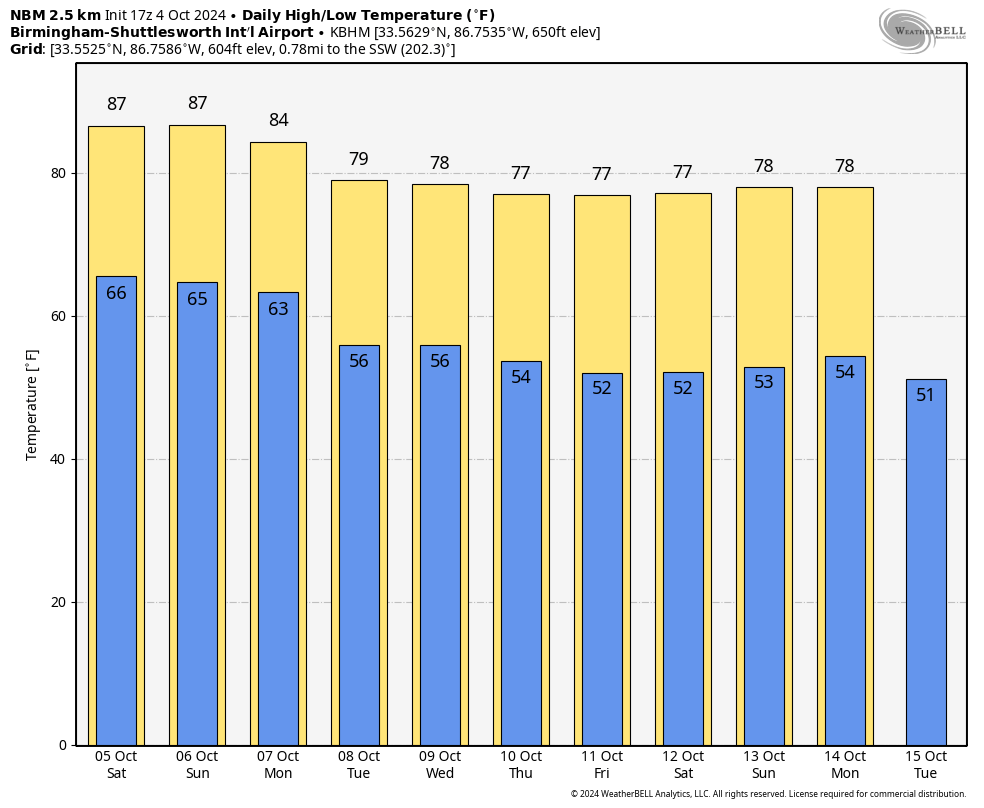
RADAR CHECK: Light rain is fairly widespread across southwest Alabama this afternoon; showers are widely spaced over the northern half of the state. Temperatures are in the 70s over south Alabama with clouds and rain. The northern counties, where the sun is out in spots, are in the low to mid 80s. Showers will fade quickly after dark, and the sky becomes mostly fair tonight with a low in the 60s.THE ALABAMA WEEKEND: Highs remain in the 80s Saturday and Sunday with a partly to mostly sunny sky both days. We will keep some risk of showers in the forecast for far southern Alabama, but nothing too widespread or heavy.
COOL CHANGE: While Monday will be another warm day, a dry cold front will bring a cool change to the Deep South beginning Tuesday. Highs drop into the 70s over north and central Alabama, with lows in the 50s. The high will be close to 80 over south Alabama, and the week will be dry with sunny days and fair nights. We see no significant rain for Alabama for the next 10-15 days. This is common for October, the driest month of the year here based on climatology.TROPICS: Kirk remains a major hurricane with winds of 140 mph, but it is in the middle of the Atlantic, far from land. It turns north, then northeast well east of the U.S. Behind Kirk is Tropical Storm Leslie with winds of 65 mph. It should become a hurricane over the next 24 hours, but, like Kirk, it will remain far from land.
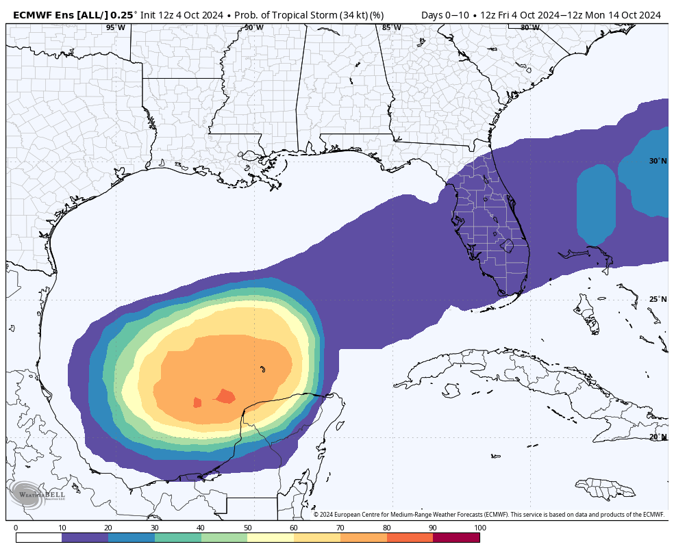
A trough of low pressure over the western Gulf of Mexico is producing widespread showers and thunderstorms. A broad area of low pressure is expected to develop from this system over the southwestern or south-central Gulf of Mexico during the next day or two, and additional subsequent development is possible while the low moves slowly eastward or northeastward. A tropical or subtropical depression or storm could form during the early to middle part of next week if the low remains separate from a frontal boundary that is forecast to extend across the Gulf of Mexico.
Regardless of tropical or subtropical development, locally heavy rains could occur over portions of Mexico during the next few days and over portions of the Florida Peninsula late this weekend into next week. The latest global models move the tropical low into south Florida Wednesday.
Advertisement
The National Hurricane Center gives this feature a 50% chance of development. We see no risk of a tropical storm or hurricane for the central Gulf Coast (Gulf Shores to Panama City Beach) for at least the next seven days.FOOTBALL WEATHER: There’s just a small risk of a shower during the first quarter for the high school games tonight. Otherwise, it will be mostly fair and pleasant; temperatures will fall through the 70s.
Saturday, UAB will host Tulane at Protective Stadium in downtown Birmingham (noon kickoff). The sky will be mostly sunny with temperatures in the low to mid 80s.
Auburn will be on the road at Georgia (2:30 p.m. CT kickoff). The sky will be sunny with temperatures in the low 80s through most of the game.
Alabama travels to Nashville to take on Vanderbilt (3:15 p.m. CT kickoff). Expect a sunny sky with temperatures falling from near 85 degrees at kickoff to near 80 by the final whistle.
RACE WEEKEND: There’s just an outside risk of a shower today at Talladega; otherwise, it will be warm and dry through the weekend with highs in the mid 80s. Lows will be in the 60s.
ON THIS DATE IN 1995: Opal made landfall at Pensacola Beach as a Category 3 hurricane with top sustained winds of 115 mph. Opal at that time was the first major hurricane to strike the Florida Panhandle since Eloise in 1975.
Advertisement
Opal’s legacy will always be the devastating storm surge that occurred across the coastal areas of the western Florida Panhandle. Storm surge of 10-15 feet was recorded from Navarre Beach east to Destin, with 6-8 feet observed in the inland bays from Pensacola to Choctawhatchee Bay. Opal destroyed most of the homes that were facing the Gulf of Mexico from Navarre Beach to east of Destin.
Opal was a high-impact event for most of inland Alabama. Rainfall measured at the Birmingham Airport reached 6.94 inches for the day, with major flooding in parts of the city. There were two storm-related deaths in Gadsden, in Etowah County, when high wind toppled a massive oak tree onto their mobile home.
For more weather news and information from James Spann and his team, visit AlabamaWx.
Tennessee Volunteers forward Alyssa Latham (33) fouls Alabama Crimson Tide guard Jessica Timmons (23)Thursday, March 5, 2026, during the SEC Women’s Basketball Tournament second round game at Bon Secours Wellness Arena in Greenville, South Carolina. Alabama Crimson Tide won 76-64.
(Alex Martin/Greenville News, Alex Martin/Greenville News / USA TODAY NETWORK via Imagn Images)
Former Alabama guard Jalil Bethea has officially committed to Pittsburgh, per Rivals’ Joe Tipton.
Bethea struggled to make a consistent impact throughout his one and only season at Alabama. The former Miami transfer averaged 3.9 points, 1.7 rebounds and 0.5 assists this past season, as Bethea could potentially play a much larger role throughout his time at Pitt next year. Bethea averaged just eight minutes per game this season as well, as the former Crimson Tide guard will now turn his full attention towards a fresh start with the Panthers.
Bethea was ranked as the No. 3 shooting guard and the No. 7 overall player from the class of 2024, per the 247Sports Composite rankings. He was listed as the No. 1 overall player out of Pennsylvania as well, as a return to his home state could undoubtedly be exactly what Bethea needs to turn his career around during the 2026-27 campaign.
Following the commitment of Bethea, Aiden Sherrell and Taylor Bol Bowen are the lone Alabama players in the portal who have yet to announce a transfer decision.
Advertisement
Contact/Follow us @RollTideWire on X (formerly Twitter) and like our page on Facebook to follow ongoing coverage of Alabama news, notes and opinion.
Lawrence County crash kills mother and 2 children, injures 2
Advertisement
TEACH OTHERS THESE SAME SKILLS. IT’S A BEAUTIFUL DAY OUT AT REGIONS FIELD, THE SKIES ARE BLUE. IT LOOKS LIKE THERE ARE SOME PEOPLE OUT THERE ON THE FIELD, AND JUST A GREAT DAY TO SOAK UP THE SUN 84 DEGREES RIGHT NOW IN BIRMINGHAM AND ACROSS THE MAP. WE ARE IN THE MID TO LOW 80S FROM 84 IN WINFIELD JASPER ALABASTER. SAME THING IN PELL CITY AND ANNISTON. THE WARMEST SPOT ON THE MAP 85 THE COOLER SPOT IN THE MAP UP IN COLEMAN AT 82 AND 82 DEGREES UP THERE IN ALBERTVILLE TOO. RADAR IS DRY. HAS BEEN FOR THE PAST 6 TO 7 DAYS, AND THE REST OF THIS EVENING WILL REMAIN DRY. WILL DROP TO THE 80S LOW 80S BY 7:00, MID 70S BY 9:00, AND THEN OVERNIGHT WILL DROP TO THE 60S AND WILL WAKE UP TOMORROW MORNING IN THE MID TO UPPER 50S. SO MAYBE A LITTLE BIT CHILLY FOR SOME, BUT OTHERWISE WARM AND WARMER THAN WE SHOULD BE FOR THIS TIME OF YEAR, NOT ONLY IN THE MORNING, BUT IN THE AFTERNOON. TOMORROW TOO. WE’RE BACK IN THE MID 80S, SIMILAR TO WHAT WE WERE TODAY, WITH JUST A LITTLE BIT MORE HUMIDITY. NOW WE HAVE NOT SEEN THAT MUCH RAINFALL SO FAR THIS ENTIRE MONTH. THIS IS MONTH TO DATE. AS YOU CAN SEE, TODAY IS THE 12TH. WE HAVE UP TO 11. AND ANYWHERE YOU SEE THAT ORANGE COLOR, THAT’S WHERE WE’VE SEEN NO RAIN. THE BEST RAINFALL WE GOT WAS LAST WEEKEND, MAINLY ON SATURDAY WITH JUST A LITTLE BIT MORE EARLY SUNDAY MORNING. NOW THIS IS JUST FOR BIRMINGHAM AND IT REPRESENTS A DROUGHT. AND THAT’S NOT JUST THE CASE FOR BIRMINGHAM. IT’S THE CASE FOR MOST OF ALABAMA. THIS RED AND THE DARK RED COLORS REPRESENT ANYWHERE BETWEEN ONE AND UP TO THREE, IF NOT FOUR INCHES OF A 30 DAY RAINFALL DEFICIT, MEANING WE NEED MORE RAIN THAN WE’VE GOTTEN IN THE PAST 30 DAYS. AND THAT LACK OF RAIN PULLING A LOT OF MOISTURE OUT OF THE GROUND DUE TO THAT DROUGHT IS WHY THERE’S A RED FLAG WARNING IN PLACE FOR BOTH NORTH AND PARTS OF CENTRAL ALABAMA. FROM FLORENCE ALL THE WAY DOWN LINEVILLE CLAY COUNTY, TALLADEGA. SHELBY. JEFFERSON. JEFFERSON WALKER ALL THE WAY UP TO MARION COUNTY’S. JUST MEANS THAT THERE IS A HIGHER FIRE DANGER. SO DON’T BE BURNING ANYTHING OUTSIDE TODAY, EVEN THE NEXT SEVERAL DAYS, BECAUSE FIRE RISK IS HIGH AS THE DROUGHT CONTINUES. HERE’S A FORECAST MODEL SHOWING WHERE WE COULD SEE THE MOST RAINFALL OVER THE NEXT SEVEN DAYS. AND AS YOU CAN SEE, ALABAMA, GEORGIA, FLORIDA, NOT MUCH. NORTHWEST ALABAMA COULD SEE A TRACE OF SHOWERS AS THESE TINY ISOLATED SHOWERS POP UP MONDAY EVENING ACROSS MARION FRANKLIN LAUDERDALE COUNTY BUT EVEN THAT CLEARS OUT AS EARLY AS 10 P.M. MONDAY NIGHT. AND OVERALL, IT’S NOT A WHOLE LOT. BUT HERE’S THAT SEVEN DAY FORECAST. HIGH STICK AROUND IN THE 80S AS HIGH AS 89 FRIDAY AFTERNOON. A FEW CHANCES FOR ISOLATED SHOWERS THURSDAY THAT RETURNS SATURDAY A
Advertisement
Lawrence County crash kills mother and 2 children, injures 2
Updated: 7:42 PM CDT Apr 12, 2026
Editorial Standards ⓘ
Advertisement
Video above: Weather forecastThree people died and two were injured, including children, in a northern Alabama car crash Saturday, according to our news partner WAFF.The Lawrence County coroner told WAFF that a vehicle driven by Ashley Hagood, 33, was hit on the side by a truck near Highway 157 and Highway 24 in Moulton.Hagood and her four children — Bryant Ballew, 13; twins Bryleigh and Brynleigh Pledger, 7; and Bentley Pledger, 10 — were inside the car at the time of the crash. Ballew and Bryleigh died at the scene, while Hagood was taken to a hospital, where she later died.Bentley and Brynleigh were taken to a hospital in Birmingham. According to WAFF, Bentley was taken off a ventilator Sunday afternoon. Brynleigh is recovering from surgery and dealing with brain swelling and bleeding, which doctors anticipated and hope the surgery will alleviate. Brynleigh also reportedly suffered seizures Saturday night.The crash remains under investigation, according to WAFF.
MOULTON, Ala. —
Video above: Weather forecast
Three people died and two were injured, including children, in a northern Alabama car crash Saturday, according to our news partner WAFF.
Advertisement
The Lawrence County coroner told WAFF that a vehicle driven by Ashley Hagood, 33, was hit on the side by a truck near Highway 157 and Highway 24 in Moulton.
Hagood and her four children — Bryant Ballew, 13; twins Bryleigh and Brynleigh Pledger, 7; and Bentley Pledger, 10 — were inside the car at the time of the crash. Ballew and Bryleigh died at the scene, while Hagood was taken to a hospital, where she later died.
Bentley and Brynleigh were taken to a hospital in Birmingham. According to WAFF, Bentley was taken off a ventilator Sunday afternoon. Brynleigh is recovering from surgery and dealing with brain swelling and bleeding, which doctors anticipated and hope the surgery will alleviate. Brynleigh also reportedly suffered seizures Saturday night.
Advertisement
The crash remains under investigation, according to WAFF.

 TROPICS: Kirk remains a major hurricane with winds of 140 mph, but it is in the middle of the Atlantic, far from land. It turns north, then northeast well east of the U.S. Behind Kirk is Tropical Storm Leslie with winds of 65 mph. It should become a hurricane over the next 24 hours, but, like Kirk, it will remain far from land.
 FOOTBALL WEATHER: There’s just a small risk of a shower during the first quarter for the high school games tonight. Otherwise, it will be mostly fair and pleasant; temperatures will fall through the 70s.


