Science
Faster alerts for California megaquakes: Early-warning system gets major upgrade

California’s earthquake early-warning system is getting a seismic upgrade, one that will allow residents to receive more timely alerts about shaking from an incoming megaquake.
The upgrade, also available in Oregon and Washington, will provide features important for warnings about the “Big One.”
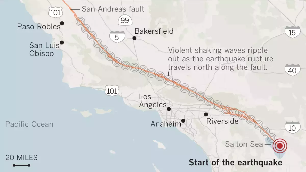
The improvements could mean that, depending on where they are and where the quake begins, Californians would receive an earlier, more accurate estimate of magnitude before the earth starts shaking — say from a magnitude 7.8 earthquake that begins on the San Andreas fault near the Mexican border and ruptures the fault toward Los Angeles County.
The upgrade also would improve warnings for the Pacific Northwest and California’s North Coast, which are threatened by tsunamis from quakes along the Cascadia subduction zone.
The U.S. Geological Survey and its nonprofit partner EarthScope announced the upgraded system Wednesday.
For the most powerful earthquakes, the improvements “become very, very critical in helping us get to the answer quicker — in terms of how big that event is,” said Robert de Groot, one of the operations team leaders of the USGS’ ShakeAlert System.
For smaller earthquakes, the older system worked “perfectly fine,” De Groot said. But with larger quakes, the magnitude could be underestimated for quite some time, robbing residents of crucial information in the seconds before they feel the most destructive shaking.
Let’s say an earthquake on the southern San Andreas fault that starts near the Mexican border ends up being a magnitude 8, but the earliest estimate says it’s a magnitude 6.5. The longer that underestimate is broadcasting to phones, the less likely people are to take appropriate action.
“People would react differently — much differently — than if you said it was a magnitude 8,” said David Mencin, vice president of data services for EarthScope, a nonprofit funded by the National Science Foundation, USGS and NASA that’s supplying data for the improved early-warning system.
“The largest, most destructive earthquakes are the ones that we’re really worried about,” Mencin said. “This fixes the problem of underestimating those magnitudes, which is critical.”
One of the most famous underestimations came in 2011 with the epic magnitude 9.1 earthquake that triggered a devastating tsunami off the eastern coast of Japan, leaving roughly 18,000 dead. An initial estimate put the quake’s magnitude at 7.9, meaning the actual earthquake was an astonishing 63 times stronger in terms of energy released.
That underestimation led to a misjudgment of tsunami heights — with some of the first detailed alerts erroneously estimating the tsunami would be lower than protective sea walls. And when communications were cut off, a false sense of security settled in, with many people never receiving accurate evacuation alerts.
Had Japan used GPS data, a more accurate magnitude of the quake could’ve been generated far more quickly, Mencin said.
The USGS’ West Coast earthquake early-warning system has long relied on hundreds of seismic sensors embedded in the ground. But there is only so much shaking they can detect in a short time.
“Seismometers tend to get overwhelmed for earthquakes that are magnitude 7 and greater. They can begin to get ‘saturated,’” Mencin said. During particularly intense shaking, the seismometers — basically objects on a spring — start to hit the wall of the instrument, and so the seismic signal is “clipped” and can’t quickly calculate magnitudes above a certain threshold.
Coming to the rescue now are hundreds of GPS sensors on Earth’s surface and run by EarthScope. Most of the time, these sensors track very slow movement, on the order of millimeters or less per year. That can illustrate subtle tectonic plate action between major earthquakes, illustrating how the Pacific plate, where L.A. is located, is nudging northwest relative to the North American plate, where the Mojave Desert is located.
But in a major earthquake, there is considerable, permanent movement of the ground, where one piece of land jolts away from the other, moving yards in seconds. In the great San Francisco earthquake of 1906, land on one side of the San Andreas fault generally jammed 8.5 feet past the other, De Groot said.
And in the last great southern San Andreas earthquake — rupturing the fault in 1857 between Monterey and San Bernardino counties — land on one side of the fault generally lurched 10 feet relative to the other side. Both the 1857 and 1906 earthquakes were somewhere around magnitude 7.8.
In the largest of the Ridgecrest earthquakes in 2019, there were about 2 feet of fault offset for the magnitude 7.1 quake, De Groot said.
The first calculation of the earthquake early-warning system will still rely on seismic sensors, which measure ground velocity and acceleration, De Groot said. Then, as a quake continues to rupture along a fault, GPS sensors will measure the distance a block of land has moved.
“What GPS allows us to do is to get a handle on how big that earthquake is getting — or could be — sooner,” De Groot said. That means the early-warning system could realize a quake was a magnitude 7, or higher, a few seconds earlier than before.
It’s important to know that an earthquake’s magnitude doesn’t appear instantly. Quakes rupture on a fault at the speed of sound through rock, which is slower than the light speed of today’s telecommunications systems. This is the principle that allows people farther away from the start of an earthquake to get seconds of advance warning of the worst shaking to come.
On the San Andreas fault, an earthquake that begins rupturing at the Salton Sea and ends at Mt. San Gorgonio, roughly 80 miles away, would produce a magnitude 7.3 earthquake.
A rupture of the San Andreas fault between the Salton Sea and Mt. San Gorgonio could produce a magnitude 7.3 quake.
(Angelica Quintero / Los Angeles Times)
But one that ruptures the entire 340-mile length of the southern San Andreas, ending in Monterey County, would create a magnitude 8.2 earthquake and produce shaking over a much wider swath of Southern and Central California.
A rupture of the entire 340-mile length of the southern San Andreas fault between Monterey County and the Salton Sea would produce a magnitude 8.2 earthquake.
(Angelica Quintero / Los Angeles Times)
“As the earthquake grows in size, it’ll be able to help update that magnitude more quickly and with more accuracy,” De Groot said of the GPS data, which will spread the early warnings to a larger region. “By adding in the [GPS] data, you actually get a handle on how big the earthquake really is sooner.”
The net result will “translate into longer warning times for people who could potentially get alerts on their phones,” De Groot said. That would give people more time to take action, such as surgeons and dentists moving sharp tools from near patients, allowing trains to slow to reduce the risk of derailment, opening firehouse doors before they can be jammed shut and giving the public time to drop, cover and hold on.
Depending on where people are, some may not get a warning before they feel the first shaking, which is known as the “P wave.” But the goal is to give a warning before the most damaging shaking occurs — the “S wave” — which comes later.
“What we really want to get people to know about is getting the alert before the strongest shaking,” De Groot said.
By the end of 2025, the USGS’ ShakeAlert — which is about 90% complete — is expected to have 1,675 seismic sensing stations. EarthScope says an additional 1,000 GPS stations run by the nonprofit are contributing data to the system.
EarthScope, the nation’s primary seismological and geodetic data facility, was recently formed as the merger of UNAVCO, which held an archive for GPS data, and IRIS, which held a seismic data archive.
The earthquake early-warning system has become more popular in recent years as people get more accustomed to the alerts. In February’s widely felt magnitude-4.6 earthquake in Malibu, some felt left out when they didn’t receive an early warning.
The alerts can be received by downloading the free MyShake app on iOS and Android. Android users are automatically subscribed to Android Earthquake Alerts. Those systems are set to sound an alarm when an earthquake is estimated to be of magnitude 4.5 or higher and the expected shaking intensity at the user’s cellphone location is expected to be at least “weak” — level 3 on the Modified Mercalli Intensity Scale, where it’s felt quite noticeably by people indoors and may rock standing motor vehicles slightly or feel like a truck is passing by.
Earthquakes of greater strength — magnitude 5 and above — will send users a wireless emergency alert, similar to an Amber Alert, if they’re in a location expected to get at least “light” shaking intensity. That’s level 4 on the Modified Mercalli Intensity Scale — shaking intensity enough to rattle dishes, windows and doors, and can feel like a heavy truck striking a building.
Science
July Fourth fireworks may bring ‘hazardous’ air quality to Southern California. What you need to know

L.A.’s love of fireworks makes for a colorful Fourth of July, with dozens of official celebrations and countless illicit explosions expected for the holiday.
But as each sparkler, Roman candle, palm and peony dissipates, it leaves behind a cloud of noxious gases, soot and finely ground toxic metals — some of which ends up in the lungs of revelers and passersby below.
Hazardous levels of air pollution are expected across central and southern Los Angeles County, northern Orange County, and Riverside and San Bernardino counties from 5 p.m. Saturday evening through 3 p.m. Sunday, according to the South Coast Air Quality Management District. Unhealthy air quality is also expected in northern Los Angeles County and southern Orange County.
Pollution levels are expected to build from dusk onward Saturday, as light winds and increased firework activity lead to an increase in smoke, a South Coast AQMD advisory said. Soot and particulates will likely linger through Sunday afternoon before being dispersed by the wind.
Firework-related pollution can trigger coughs, breathing problems, asthma flares and heart attacks, according to Los Angeles County Public Health, and anyone experiencing severe or worsening cardiovascular symptoms like chest pain or difficulty breathing should seek medical attention immediately.
Pyrotechnics set off at home are even more likely to trigger cardiovascular problems, the American Lung Assn. says, as the burst of pollutants takes place closer to the ground.
July 4 and 5 are traditionally two of the worst days of the year for the region’s air quality, according to South Coast AQMD. This year’s celebration comes on the heels of a late June warehouse fire in Boyle Heights that released extraordinary amounts of soot and smoke across the county, on par with pollution generated by the previous year’s wildfires.
To limit negative health effects, the L.A. County public health department recommends avoiding strenuous physical activity and keeping doors and windows closed. As whole house fans and swamp coolers can suck additional pollutants inside, the department recommends using air purifiers or air conditioners as alternatives when possible.

Few substances are as deeply woven into everyday life as alcohol. It is a fixture at holiday celebrations, work-related social gatherings, sporting events, airports, and brunch or dinner tables. All demonstrate how deeply alcohol has become embedded in social customs and cultural traditions.
Yet alcohol contributes to millions of deaths globally each year and is linked to cancer, liver disease, unintentional accidents, violence and, importantly, dependence and addiction. Despite this, the disconnect between alcohol’s cultural role and its serious health burden is striking. An estimated 2.3 billion people worldwide consume alcohol.
As a physician working in addiction medicine, I regularly care for patients whose alcohol use affects nearly every organ system. It is often not until these patients end up admitted to the hospital that they learn the effects of alcohol on various parts of their body besides their liver.
Newer evidence challenges assumptions about what was long considered “safe drinking.” Even moderate drinking carries risk and is not as harmless as people, including experts, once thought.
Many people associate alcohol risk primarily with addiction or dangerous behaviors such as driving while intoxicated. However, its effects extend far beyond this, into nearly every aspect of a person’s well-being.
While alcohol may transiently improve mood and ease social anxiety, long-term alcohol use can lead to a worsening of mood, cognition and sleep, which can further compound use.
A 2021 literature review found that consuming approximately two standard drinks roughly doubles the odds of sustaining injuries — with or without a vehicle involved. The review also found that heavy episodic (binge) drinking can increase the risk of injury by 50-fold, depending on the amount of alcohol consumed and the type of injury. While alcohol’s effects on the liver are well known, it can also lead to gastrointestinal complications and heart disease
The World Health Organization estimates that 2.6 million deaths each year are attributable to alcohol, accounting for nearly 1 in every 20 deaths worldwide.
While many people recognize the risks of alcohol addiction, people are generally much less aware of the links between alcohol use and cancer risk.
The World Health Organization classifies alcohol as a Group 1 carcinogen — the same category as tobacco and asbestos. In 2025, the U.S. surgeon general emphasized that alcohol increases the risk of at least seven cancers, including cancers of the breast, colorectal, liver, oral, esophagus and larynx. An advisory called for updated warning labels.
Yet fewer than half of Americans recognize alcohol as a risk factor for cancer, particularly for cancers such as breast cancer that are not commonly associated with alcohol use.
Throughout the 1990s and early 2000s, observational studies suggested that moderate alcohol consumption might offer cardiovascular benefits. Over the past decade, however, higher-quality studies have challenged these findings, suggesting that much of the apparent benefit may have reflected differences in the health and lifestyles of moderate drinkers rather than a protective effect of alcohol itself.
Current evidence increasingly suggests that even low levels of alcohol may increase cancer risk.
Federal guidelines acknowledge that adults should “consume less alcohol for better overall health.” However, the most recent version of the “Dietary Guidelines for Americans,” updated in January, removed the previous recommendation to limit intake to no more than one drink per day for women and two for men. It also omitted explicit discussion of alcohol’s links to cancer.
These changes have drawn criticism from public health experts, who argue that the revised language plays down the growing evidence of alcohol-related harms and provides less specific guidance to consumers. The current administrator of the Centers for Medicare & Medicaid Services characterized alcohol as a “social lubricant” that brings people together, rather than emphasizing its well-established health risks.
This may be true physiologically, at least temporarily, but obscures the fact that relying on it as a social lubricant can lead to chemical and psychological dependency. In my view, statements to that effect are shortsighted, prioritizing short-term social effects over more insidious and long-term issues, including addiction.
While many dangerous mind-altering substances are hidden from public perception, alcohol is often placed at the center of it – a trend that shows no sign of changing imminently.
Further, large companies often profit from ads that appeal to young people.
Looking back at the history of tobacco smoking provides some helpful insights. In 1965, 42.4% of the U.S. population smoked. By 2022, that figure had dropped to 11.6%.
This steep decline did not happen because of a single intervention, but through decades of accumulating scientific evidence, public education campaigns, warning labels, restrictions on advertising, smoke-free policies, higher tobacco taxes and shifts in social norms. Together, these efforts transformed smoking from a widely accepted social behavior into one broadly recognized as a major health risk and correspondingly, less socially accepted.
Although alcohol consumption has modestly declined in recent years, it remains deeply embedded in social life in ways cigarette smoking no longer is.
People often assume that if a substance is legal, common and widely socially accepted — even encouraged — it must also be safe. But public health history suggests those assumptions can and should change.
Emma Fenske is an addiction medicine fellow and internal medicine physician at Oregon Health & Science University. This article was produced in partnership with the Conversation.

The air near the Lineage refrigerated warehouse fire in Boyle Heights carried astronomically high levels of smoke and soot, surpassing some of the worst air pollution during the Los Angeles County fires in January 2025, according to preliminary data from air officials.
The fire spewed thick black smoke for days. From downtown Los Angeles to the San Gabriel Valley, tens of thousands were enveloped in unhealthful levels of smoke, even as some local officials told residents that the air posed no danger.
As the days wore on, worst off were communities nearest the blaze. On June 19, three days after the facility ignited, a temporary air quality monitoring station at Eastman Elementary in unincorporated East Los Angeles measured an extremely hazardous 755 micrograms per cubic meter of fine particles for more than an hour, according to the South Coast Air Quality Management District.
For comparison, a Caltech air monitor in Pasadena recorded about 650 micrograms per cubic meter during the Eaton fire.
These high levels of fine particles, known as PM 2.5, probably resulted in the surge of residents into local emergency rooms during the fire, according to local health officials. But even now with the smoke gone, people still have not been told what chemicals they were breathing in during the weeklong ordeal.
Michael Jerrett, an environmental health professor at the UCLA Fielding School of Public Health, said his concern is the composition of materials emitted when the building burned.
“These contain many particularly toxic components,” Jerrett said, “and we know little about how these mixtures affect health.”
There is no completely safe level of fine particulate pollution, he noted, meaning higher concentrations are always worse.
During the 2025 L.A. County fires, local air officials announced that several monitors downwind had detected elevated levels of brain-damaging lead and cancer-causing arsenic from toxic paint and construction materials used in older homes.
The Lineage warehouse, built in 2018, is likely to contain different materials of concern. Thick insulation foam required for a massive refrigeration operation, solar panels and refrigerants were burned, leaving many residents on edge.
Even though three public agencies conducted air monitoring, the picture is still murky.
“[Public officials] are speaking with a lot of confidence but not a lot of information,” said mark! Lopez, a community organizer with East Yard Communities for Environmental Justice. “We’ve gotten in the room with folks to discuss where the gaps lie and where assumptions are being made. And I think they are realizing these agencies supposed to protect our air and our health aren’t as reliable as they thought they were.”
In response to the Boyle Heights fire, the South Coast air district deployed a mobile monitoring vehicle to screen for toxic substances in the community near the fire, according to Nahal Mogharabi, a spokesperson for the air district. It found increased levels of bromine, a chemical commonly found in fire retardant, and chlorine, often released from burning plastic. Both were below short-term health-based exposure thresholds.
Toxic metals, including lead and arsenic, were not elevated, according to air district data.
“That was the reassuring piece, that they were not picking up any of the metals,” said Dr. Nichole Quick, chief medical advisor for the Los Angeles County Department of Public Health. “But … that smoke is unhealthy. “You don’t want to be breathing it, regardless.”
The U.S. Environmental Protection Agency set up air monitors around the perimeter of the facility to test for toxic air contaminants, has the results and has not made them public. Julia Giarmoleo, an EPA spokesperson, said the monitors did not detect elevated metals, but would not provide a copy of the data without a federal records request.
The Los Angeles Fire Department’s hazardous material team also tested for ammonia, which is used in refrigeration, and hydrogen fluoride, a toxic chemical that could be released by burning lithium-ion batteries and solar panels.
Fire officials previously said they measured low levels of hydrogen fluoride on the second day of the fire. But the department would not answer questions about its air monitoring. It also told a reporter to submit a public records request.
It remains unclear whether any agency has tested for hydrogen cyanide or isocyanates, highly toxic gases that could be released from burning chemical-laden insulating foam inside the building.
“The real issue is what monitoring has not been done to protect the fence-line community from the air toxics,” said Jane Williams, executive director of California Communities Against Toxics.
Without the EPA or LAFD data, what is known of the smoke’s toxicity rests on the air district’s mobile monitoring.
Jerrett, the UCLA researcher, said that is not ideal for understanding the kind of plume released by the Boyle Heights fire, which rapidly changed direction with the wind.
“This can in some instances lead to levels that look low, but they are resulting from a mismatch between the location of the vehicle and the plume,” he said.
The Boyle Heights blaze, similar to the Eaton and Palisades fires, has revealed the region’s air monitoring can’t always tell people what they’ve been exposed to in a disaster.
“We do need a better monitoring system in place,” he said.
Local officials are now shifting their focus to the rancid odors from millions of pounds of rotting food in the ruined wing of the warehouse. Decomposing food can release hydrogen sulfide, a toxic gas synonymous with landfills and garbage. Lineage hired contractors who are measuring this noxious gas and other pollution. Their data indicate they have not detected hydrogen sulfide.
As Lineage workers haul the rotting food to local landfills, they are using deodorizing mist and have discussed using shrink wrapping to suppress the stench and minimize issues for nearby homes.
At this point, the odors are believed to be an inconvenience rather than a public health threat, according to Quick, the county medical advisor. She said running air purifiers may help to reduce odors indoors.
“It’s very important for folks to understand that the odors themselves do not indicate any dangerous levels of toxins, mold, bacteria, and so forth,” Quick said. “But the odors are a public nuisance.”
The air district is still encouraging residents to report odors to its online complaint system or by calling (800) 288-7664.
-

 Los Angeles, Ca20 minutes ago
Huntington Park announces street closures ahead of Mexico World Cup match
-

 Detroit, MI42 minutes ago
Mallory McMorrow drops out of Michigan’s US Senate race
-

 San Francisco, CA50 minutes ago
Waymo Vehicle Catches Fire in San Francisco
-

 Dallas, TX51 minutes ago
Dallas police and fire teams seize of nearly a ton of illegal fireworks
-

 Miami, FL57 minutes ago
Triple shooting, crash sends adults to hospital, Miramar police say
-

 Boston, MA60 minutes ago
After monthlong break, Boston Legacy FC battles back to earn a draw with Bay FC – The Boston Globe
-

 Denver, CO1 hour ago
Denver airport to add underground walkways between concourses – The Points Guy
-

 Seattle, WA1 hour ago
READER REPORT: ‘My hero’

