Science
Can satellites combat wildfires? Inside the booming 'space race' to fight the flames

As the threat of wildfire worsens in California and across the world, a growing number of federal agencies, nonprofit organizations and tech companies are racing to deploy new technology that will help combat flames from a whole new vantage point: outer space.
New satellite missions backed by NASA, Google, SpaceX, the California Department of Forestry and Fire Protection and other groups were announced this week and promise to advance early wildfire detection and help reduce fire damage by monitoring Earth from above.
Collectively, the roster of big names, billionaires, government groups and nongovernmental organizations reflects a considerable interest in using new technology to solve some of humanity’s biggest problems.
Among them is the Earth Fire Alliance, a global nonprofit coalition that recently unveiled its vision for a constellation of more than 50 satellites that will focus specifically on wildfires and their ecological effects.
Known as FireSat, the orbiting surveillance network will scan the globe every 20 minutes in search of wildfire activity — analyzing the landscape across six spectral bands that can spot signs of fires through clouds, smoke, darkness and extreme sunlight, according to the organization. The first three satellites will be launched and operational by 2026.
“It’s really a game-changer when it comes to resource allocation, because now we have this really high-fidelity picture that’s very, very granular of every single fire, which will ultimately help us better deploy resources in a much more efficient manner,” said Chris Anthony, an Earth Fire Alliance board member and former chief deputy director at Cal Fire.
Earth Fire Alliance’s FireSat Constellation will consist of multiple Muon Halo satellites equipped with state-of-the-art 6-band multispectral infrared (IR) instruments designed to detect and track the impact of wildfires across the planet.
(Muon Space)
Data and images gathered from FireSat will not only inform crews about the location of fires, but also how hot they are and how fast they are moving — helping to guide firefighting, emergency operations and evacuations, Anthony said.
He noted that during his career battling blazes, he often wondered when California would use its reputation as a global hub of technology and innovation to tackle the issue of wildfires.
“With every large wildfire we have — and the emissions and the carbon that’s released in that smoke — I feel like we’re in this negative feedback loop, which is going to be really hard for us to get out of,” he said. “And I strongly believe that technology and innovation is a core component of our ability to turn this ship in the other direction. I mean, we have to — I don’t think we have a choice.”
Indeed, while California has enjoyed two relatively tame fire seasons thanks to back-to-back wet winters, the threat has not dissipated.
The state has experienced the majority of its largest, deadliest and most destructive blazes since the year 2000, according to data from Cal Fire. The state’s worst wildfire year on record, 2020, saw nearly 4.4 million acres burn and the state’s first million-acre fire, the August Complex.
Experts say wildfires here are expected to grow larger, faster and more frequent in the years ahead due in part to warmer and drier conditions driven by human-caused climate change, as well as vegetation buildup and forest management practices. Similar trends are expected globally, where wildfires are projected to increase 30% by mid-century, according to the United Nations.
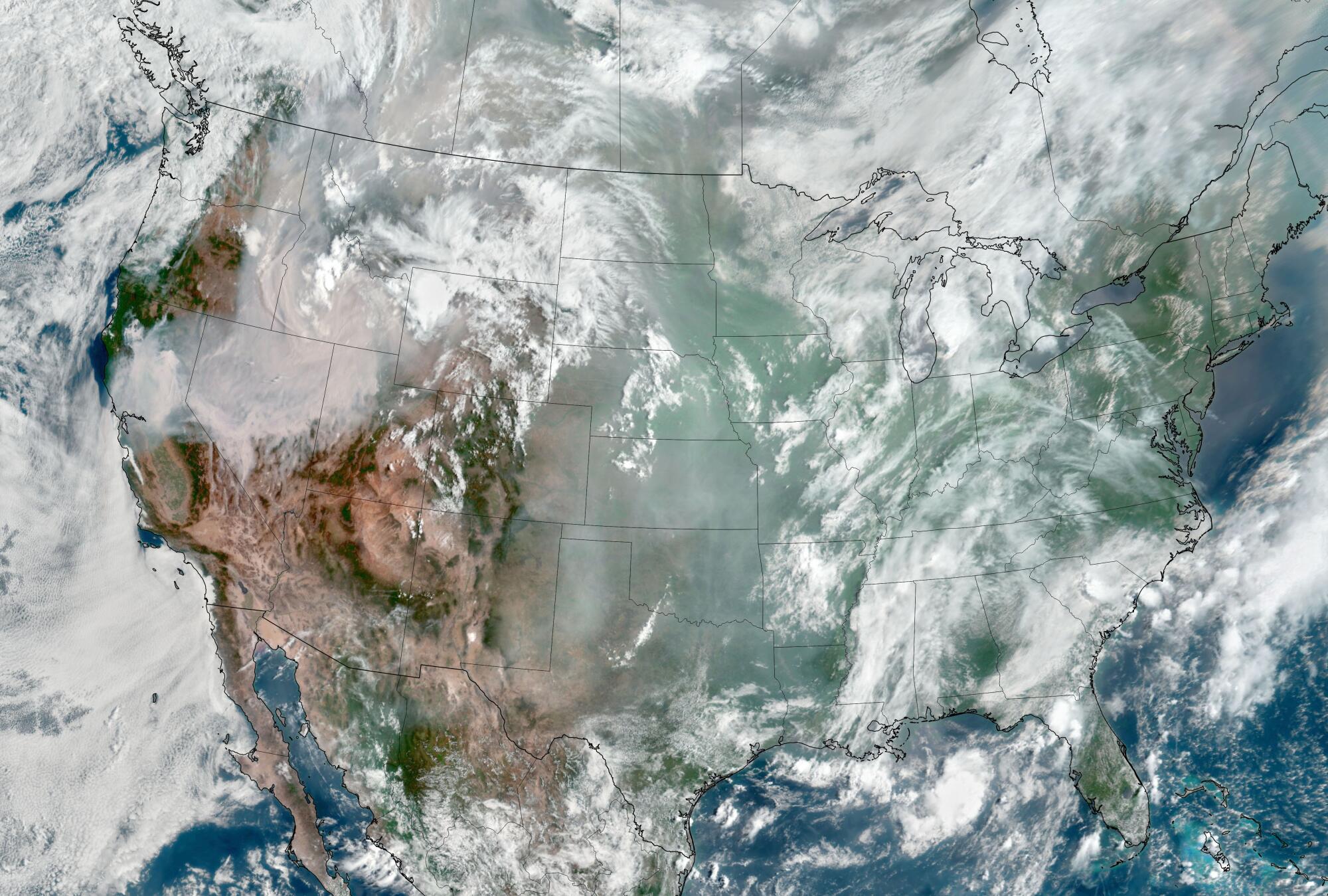
Images taken by the Geostationary Operational Environmental Satellite 17 (GOES-17) show smoke blanketing portions of the western United States at the time of the Dixie fire, in August 2021.
(Courtesy of NOAA and the National Environmental Satellite, Data, and Information Service)
Earlier this year, Texas experienced its largest wildfire on record, which burned through more than a million acres, claimed two lives and killed at least 7,000 cattle.
Last year, a relentless procession of fires seared more than 45 million acres across Canada and sent noxious smoke billowing into parts of the United States and all the way to Europe.
“Even though California has been at the epicenter of so many large and destructive fires, it is becoming super clear that the wildfire problem that we have right now isn’t just a California, or a Western states, problem, but it is truly a global issue that we need to resolve,” Anthony said.
The Earth Fire Alliance’s satellites will join similar missions from NASA and the National Oceanic and Atmospheric Administration. The agencies announced this week that they will soon launch GOES-U, the last in their series of four advanced weather satellites, which provide continuous monitoring of much of the Western Hemisphere.
Roughly the size of a small school bus, the GOES-U satellite was designed and built in partnership with defense contractors Lockheed Martin and L3Harris. It will lift off on June 25 aboard a SpaceX Falcon Heavy Rocket from NASA’s Kennedy Space Center in Florida, and will provide rapid data for tracking severe storms, including destructive wildfires and their smoke, as well as tropical systems, floods, lightning, snowstorms, dense fogs and other hazards, officials said.
“NOAA’s geostationary satellites are an indispensable tool for protecting the United States and the 1 billion people who live and work in the Americas,” Pam Sullivan, director of NOAA’s Office of Geostationary Earth Orbit Observations, told reporters Wednesday.
GOES-U — which will be renamed GOES-19 once in orbit — will scan the Earth every 10 minutes, and can zoom in to track dangerous storms and hazards with 30-second updates, she said.
It will also carry the first operational compact coronagraph that will help detect space weather for early warnings of disruptions to power grids, communications and navigation systems. Earlier this month, a powerful geomagnetic storm prompted some reports of such impacts.
The GOES series will play a critical role in hurricane tracking, but perhaps its “biggest game-changing aspect” is its ability to detect wildfires, said Dan Lindsey, a program scientist with NOAA.
“We knew it could detect fires, of course, but it is able to do this in a much more impressive way than we foresaw,” Lindsey said. He said the GOES series has already detected fires the size of a small barn, but the new imaging tools will have four times better spatial resolution on its fire detection band.
“This is important because it allows us to get the word out to emergency responders, firefighters and take care of those fires as quickly as possible,” he said.
Experts are also experimenting with more terrestrial technology to combat conflagrations, including the use of artificial intelligence tools to fight wildfires in California.
One program — a Cal Fire partnership with UC San Diego’s ALERTCalifornia system announced last year — includes more than 1,000 high-definition cameras across the state that use AI to scan the landscape and alert fire crews to burgeoning blazes.
The system is already proving effective, with its pilot program flagging dozens of fires before 911 calls came in, officials said.
A rendering of a GOES-U satellite orbiting Earth.
(NOAA / Lockheed Martin)
Still, space is its own frontier which brings with it its own set of challenges. Rocket launches are known to emit considerable planet-warming carbon dioxide, along with black carbon, methane and other pollutants.
Last fall, a United Nations report also warned of new risks from growing space debris — including roughly 8,300 satellites and 35,000 other tracked objects that are circling the Earth, many of which are used for weather monitoring, early warning systems and global communications.
Too many orbiting objects run the risk of collision, which could set off a chain reaction that takes those systems offline, the report said.
But new regulations and designs are helping to mitigate some of those risks, said Brian Collins, interim executive director at Earth Fire Alliance. The potentially life- and property-saving benefits of the technology are also part of the balance.
A new economic report published by the alliance and the consulting firm Mandala Partners found that early detection of fires could reduce annual direct fire damage costs by approximately $1.2 billion across the U.S., Australia and Southern Europe. Wildfires in the U.S. alone cost about $11.3 billion annually, with property damage accounting for a large part of that — a trend that has already seen some insurers flee the Golden State and other fire-prone regions.
Indirect costs from fires in the U.S. could be as large as $415 billion annually, including labor productivity losses and health costs, the report found. Almost half — 46% — of the wildfire costs are borne by local communities and businesses.
The Earth Fire Alliance’s suite of satellites will fly at a lower orbit — about 370 miles from Earth compared with NOAA’s 22,000 miles — affording even more granular information in real time, Collins said.
“We view it as complementary to the big, heavy lift systems that NOAA and NASA produce,” he said. “Knowing where a fire is — on this side of the road or that side of a road, or on one side of a hill or another — is very important to the ecosystem and to the first responders.”
The Earth Fire Alliance raised $12 million in its early round of investments, and is on its way to securing an additional $50 million to $60 million to get the first three satellites into space, he said. The full constellation of 50 or more satellites will require about $300 million to $400 million, some of which will come from partnerships.
The alliance’s supporters include Google.org, the Environmental Defense Fund, the Minderoo Foundation and the Gordon & Betty Moore Foundation.
It made sense to tackle the issue of wildfires through the nonprofit structure, which can move more nimbly than government agencies that are tied to specific funding cycles, Collins said. However, data captured by FireSat can be integrated with NASA and NOAA and will be provided to all users for free.
“The reason for the organization was largely those two things — capturing a budgetary process, and interest and passion that can move a little quicker,” he said. “This was a nice blend to fill a gap of a capability while advancing the mission.”
Anthony, the former Cal Fire chief, said the FireSat program will not only help guide attacks on ongoing fires, but also provide an added layer of intelligence around prescribed fires, or fires that are intentionally set to clear vegetation and preserve forest health. For instance, the tools can help assess the right time to apply prescribed fire, track the fire’s intensity and integrate it with fire modeling.
The thousand-mile view afforded by the satellites will mark a new era of firefighting tools with a fidelity and resolution that have never been seen before, Anthony added.
“You can understand anything if you can see everything,” he said.

Few substances are as deeply woven into everyday life as alcohol. It is a fixture at holiday celebrations, work-related social gatherings, sporting events, airports, and brunch or dinner tables. All demonstrate how deeply alcohol has become embedded in social customs and cultural traditions.
Yet alcohol contributes to millions of deaths globally each year and is linked to cancer, liver disease, unintentional accidents, violence and, importantly, dependence and addiction. Despite this, the disconnect between alcohol’s cultural role and its serious health burden is striking. An estimated 2.3 billion people worldwide consume alcohol.
As a physician working in addiction medicine, I regularly care for patients whose alcohol use affects nearly every organ system. It is often not until these patients end up admitted to the hospital that they learn the effects of alcohol on various parts of their body besides their liver.
Newer evidence challenges assumptions about what was long considered “safe drinking.” Even moderate drinking carries risk and is not as harmless as people, including experts, once thought.
Many people associate alcohol risk primarily with addiction or dangerous behaviors such as driving while intoxicated. However, its effects extend far beyond this, into nearly every aspect of a person’s well-being.
While alcohol may transiently improve mood and ease social anxiety, long-term alcohol use can lead to a worsening of mood, cognition and sleep, which can further compound use.
A 2021 literature review found that consuming approximately two standard drinks roughly doubles the odds of sustaining injuries — with or without a vehicle involved. The review also found that heavy episodic (binge) drinking can increase the risk of injury by 50-fold, depending on the amount of alcohol consumed and the type of injury. While alcohol’s effects on the liver are well known, it can also lead to gastrointestinal complications and heart disease
The World Health Organization estimates that 2.6 million deaths each year are attributable to alcohol, accounting for nearly 1 in every 20 deaths worldwide.
While many people recognize the risks of alcohol addiction, people are generally much less aware of the links between alcohol use and cancer risk.
The World Health Organization classifies alcohol as a Group 1 carcinogen — the same category as tobacco and asbestos. In 2025, the U.S. surgeon general emphasized that alcohol increases the risk of at least seven cancers, including cancers of the breast, colorectal, liver, oral, esophagus and larynx. An advisory called for updated warning labels.
Yet fewer than half of Americans recognize alcohol as a risk factor for cancer, particularly for cancers such as breast cancer that are not commonly associated with alcohol use.
Throughout the 1990s and early 2000s, observational studies suggested that moderate alcohol consumption might offer cardiovascular benefits. Over the past decade, however, higher-quality studies have challenged these findings, suggesting that much of the apparent benefit may have reflected differences in the health and lifestyles of moderate drinkers rather than a protective effect of alcohol itself.
Current evidence increasingly suggests that even low levels of alcohol may increase cancer risk.
Federal guidelines acknowledge that adults should “consume less alcohol for better overall health.” However, the most recent version of the “Dietary Guidelines for Americans,” updated in January, removed the previous recommendation to limit intake to no more than one drink per day for women and two for men. It also omitted explicit discussion of alcohol’s links to cancer.
These changes have drawn criticism from public health experts, who argue that the revised language plays down the growing evidence of alcohol-related harms and provides less specific guidance to consumers. The current administrator of the Centers for Medicare & Medicaid Services characterized alcohol as a “social lubricant” that brings people together, rather than emphasizing its well-established health risks.
This may be true physiologically, at least temporarily, but obscures the fact that relying on it as a social lubricant can lead to chemical and psychological dependency. In my view, statements to that effect are shortsighted, prioritizing short-term social effects over more insidious and long-term issues, including addiction.
While many dangerous mind-altering substances are hidden from public perception, alcohol is often placed at the center of it – a trend that shows no sign of changing imminently.
Further, large companies often profit from ads that appeal to young people.
Looking back at the history of tobacco smoking provides some helpful insights. In 1965, 42.4% of the U.S. population smoked. By 2022, that figure had dropped to 11.6%.
This steep decline did not happen because of a single intervention, but through decades of accumulating scientific evidence, public education campaigns, warning labels, restrictions on advertising, smoke-free policies, higher tobacco taxes and shifts in social norms. Together, these efforts transformed smoking from a widely accepted social behavior into one broadly recognized as a major health risk and correspondingly, less socially accepted.
Although alcohol consumption has modestly declined in recent years, it remains deeply embedded in social life in ways cigarette smoking no longer is.
People often assume that if a substance is legal, common and widely socially accepted — even encouraged — it must also be safe. But public health history suggests those assumptions can and should change.
Emma Fenske is an addiction medicine fellow and internal medicine physician at Oregon Health & Science University. This article was produced in partnership with the Conversation.

The air near the Lineage refrigerated warehouse fire in Boyle Heights carried astronomically high levels of smoke and soot, surpassing some of the worst air pollution during the Los Angeles County fires in January 2025, according to preliminary data from air officials.
The fire spewed thick black smoke for days. From downtown Los Angeles to the San Gabriel Valley, tens of thousands were enveloped in unhealthful levels of smoke, even as some local officials told residents that the air posed no danger.
As the days wore on, worst off were communities nearest the blaze. On June 19, three days after the facility ignited, a temporary air quality monitoring station at Eastman Elementary in unincorporated East Los Angeles measured an extremely hazardous 755 micrograms per cubic meter of fine particles for more than an hour, according to the South Coast Air Quality Management District.
For comparison, a Caltech air monitor in Pasadena recorded about 650 micrograms per cubic meter during the Eaton fire.
These high levels of fine particles, known as PM 2.5, probably resulted in the surge of residents into local emergency rooms during the fire, according to local health officials. But even now with the smoke gone, people still have not been told what chemicals they were breathing in during the weeklong ordeal.
Michael Jerrett, an environmental health professor at the UCLA Fielding School of Public Health, said his concern is the composition of materials emitted when the building burned.
“These contain many particularly toxic components,” Jerrett said, “and we know little about how these mixtures affect health.”
There is no completely safe level of fine particulate pollution, he noted, meaning higher concentrations are always worse.
During the 2025 L.A. County fires, local air officials announced that several monitors downwind had detected elevated levels of brain-damaging lead and cancer-causing arsenic from toxic paint and construction materials used in older homes.
The Lineage warehouse, built in 2018, is likely to contain different materials of concern. Thick insulation foam required for a massive refrigeration operation, solar panels and refrigerants were burned, leaving many residents on edge.
Even though three public agencies conducted air monitoring, the picture is still murky.
“[Public officials] are speaking with a lot of confidence but not a lot of information,” said mark! Lopez, a community organizer with East Yard Communities for Environmental Justice. “We’ve gotten in the room with folks to discuss where the gaps lie and where assumptions are being made. And I think they are realizing these agencies supposed to protect our air and our health aren’t as reliable as they thought they were.”
In response to the Boyle Heights fire, the South Coast air district deployed a mobile monitoring vehicle to screen for toxic substances in the community near the fire, according to Nahal Mogharabi, a spokesperson for the air district. It found increased levels of bromine, a chemical commonly found in fire retardant, and chlorine, often released from burning plastic. Both were below short-term health-based exposure thresholds.
Toxic metals, including lead and arsenic, were not elevated, according to air district data.
“That was the reassuring piece, that they were not picking up any of the metals,” said Dr. Nichole Quick, chief medical advisor for the Los Angeles County Department of Public Health. “But … that smoke is unhealthy. “You don’t want to be breathing it, regardless.”
The U.S. Environmental Protection Agency set up air monitors around the perimeter of the facility to test for toxic air contaminants, has the results and has not made them public. Julia Giarmoleo, an EPA spokesperson, said the monitors did not detect elevated metals, but would not provide a copy of the data without a federal records request.
The Los Angeles Fire Department’s hazardous material team also tested for ammonia, which is used in refrigeration, and hydrogen fluoride, a toxic chemical that could be released by burning lithium-ion batteries and solar panels.
Fire officials previously said they measured low levels of hydrogen fluoride on the second day of the fire. But the department would not answer questions about its air monitoring. It also told a reporter to submit a public records request.
It remains unclear whether any agency has tested for hydrogen cyanide or isocyanates, highly toxic gases that could be released from burning chemical-laden insulating foam inside the building.
“The real issue is what monitoring has not been done to protect the fence-line community from the air toxics,” said Jane Williams, executive director of California Communities Against Toxics.
Without the EPA or LAFD data, what is known of the smoke’s toxicity rests on the air district’s mobile monitoring.
Jerrett, the UCLA researcher, said that is not ideal for understanding the kind of plume released by the Boyle Heights fire, which rapidly changed direction with the wind.
“This can in some instances lead to levels that look low, but they are resulting from a mismatch between the location of the vehicle and the plume,” he said.
The Boyle Heights blaze, similar to the Eaton and Palisades fires, has revealed the region’s air monitoring can’t always tell people what they’ve been exposed to in a disaster.
“We do need a better monitoring system in place,” he said.
Local officials are now shifting their focus to the rancid odors from millions of pounds of rotting food in the ruined wing of the warehouse. Decomposing food can release hydrogen sulfide, a toxic gas synonymous with landfills and garbage. Lineage hired contractors who are measuring this noxious gas and other pollution. Their data indicate they have not detected hydrogen sulfide.
As Lineage workers haul the rotting food to local landfills, they are using deodorizing mist and have discussed using shrink wrapping to suppress the stench and minimize issues for nearby homes.
At this point, the odors are believed to be an inconvenience rather than a public health threat, according to Quick, the county medical advisor. She said running air purifiers may help to reduce odors indoors.
“It’s very important for folks to understand that the odors themselves do not indicate any dangerous levels of toxins, mold, bacteria, and so forth,” Quick said. “But the odors are a public nuisance.”
The air district is still encouraging residents to report odors to its online complaint system or by calling (800) 288-7664.

Federal employees who were axed during waves of cuts by the Trump administration have fought back against the dismantling of a key climate science website, Climate.gov, and put up a new site, Climate.us, that can now do everything the original did.
The site, with millions of users each year, was known for colorful charts that anyone could freely download and that simplified giant sets of data, such as temperature readings. Now it refers to another page and is no longer being updated.
Daniel Swain, a UC Agriculture & Natural Resources climate scientist, called the resources available at Climate.gov “the most efficacious dollars spent by NOAA on public-facing science, possibly ever.” He has used graphics from the former website on his popular weather blog.
“I am a terrible artist or illustrator. It would be very bad if I had to create those on my own.” Swain said. The website didn’t just make graphics that were beautiful, he said, they were accurate and reliable because of the network of researchers who fact-checked them.
Rebecca Lindsey was the editorial lead and program manager for Climate.gov until February 2025, when her position at the National Oceanic and Atmospheric Administration was eliminated by the Elon Musk-led Department of Government Efficiency, or DOGE. She explained that the online resource was “a bridge between scientists, data and the public.”
Lindsey and her team have now rebuilt the bridge piece by piece, if just a bit further downstream.
The team is made of the same editorial and technical staff that ran Climate.gov. It’s paid for through a crowdfunding campaign and one large, anonymous donation.
The group has raised some $380,000, about $100,000 of which came in the last week. They also have recruited 80 scientists who are willing to volunteer as subject matter experts and fact checkers. It’s enough to keep the work going through February while they seek more long-term funding.
The first iteration of Climate.us went online in 2025 to keep the last 15 years of work from the government website available. The newest version restores the full function of the previous website.
For Californians, the timing could be important.
“We’re headed for a very strong El Niño event that will have significant implications for Southern California,” Swain said. “Climate.gov and the scientists behind it did a great job walking people through the last one, and I would expect that’s the case this time as well.”
Climate.gov excelled at tapping into a pool of academic experts to explain what was happening in nearly real time. This allowed the public to see how events such as wildfire, drought or large weather patterns such as El Niño were shaping their lives when they needed the information most. Research from academic institutions, by contrast, can take years to publish results from major natural disasters.
Swain emphasized that cuts to resources that give context to hard-to-interpret data is not just a loss for the research community.
“It’s getting more and more difficult for the American public to access the science and the scientists that their tax dollars have supported for over half a century,” he said.
With the revival of Climate.us, Swain said he plans to directly use the site and its graphics to keep Californians connected to the world of climate science.
-

 Louisiana2 minutes ago
Supreme Court rules in indictment against Louisiana attorney general
-

 Maine9 minutes ago
Magalloway Conservation Project in western Maine nearing completion
-
 Maryland12 minutes ago
Baltimore Gas and Electric seeks $8 monthly rate increase for Maryland customers
-

 Michigan17 minutes ago
Michigan lawmakers work through the night on ‘compromise’ budget
-

 Massachusetts24 minutes ago
Massachusetts city imposes curfew ahead of historic World Cup match
-
Minnesota27 minutes ago
Where to watch Minnesota Lynx vs New York Liberty on July 3: TV channel, start time and streaming
-

 Mississippi32 minutes ago
List of Jackson area events to celebrate July 4th before firework shows
-

 Missouri39 minutes ago
Most Missouri state and Columbia offices closed Friday; Columbia parking meters will not be enforced during Fourth of July weekend | 93.9 The Eagle

