West
Police investigating after hiker finds badly decomposed body hundred of yards down California cliffside

Los Angeles County Sheriff’s homicide investigators are searching for answers after a severely decomposed body was discovered on Saturday off a cliff in Rancho Palos Verdes, California.
A hiker saw the adult body from a cliff above and immediately notified authorities, according to a statement from the department.
The body was found several hundred yards down the cliff.
Investigators said they believe the person fell from Dina’s Vistapoint, but appeared to have been deceased at the location for an extended period, due to “severe decomposition.”
LOS ANGELES-AREA AUTHORITIES INVESTIGATING HUMAN LEGS FOUND ON SHORELINE
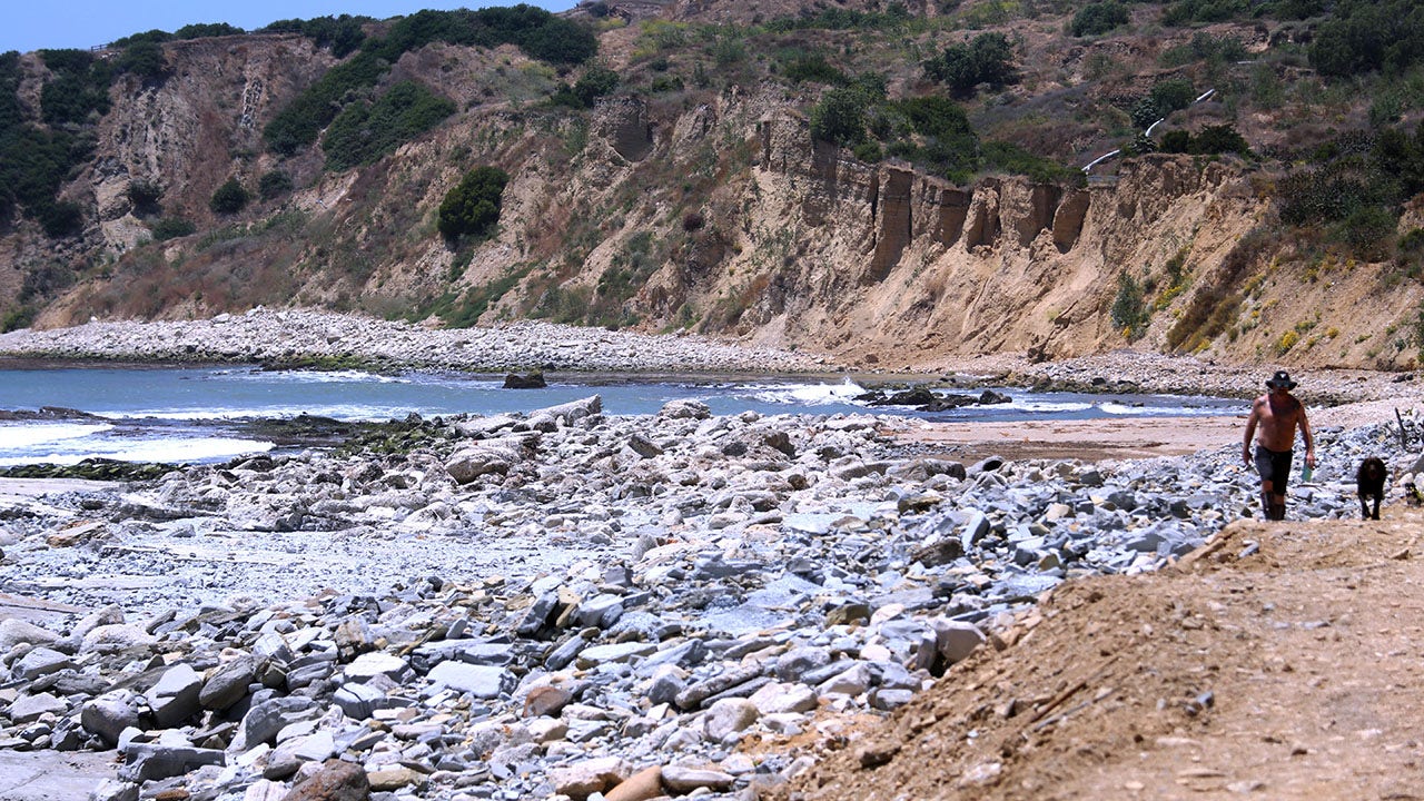
A resident walks next to a rocky coastline in Palos Verdes. Human remains were recently discovered near the shoreline. (Getty Images)
Los Angeles County Fire paramedics responded and pronounced the person dead at the scene, according to the statement.
Officials said the incident is not related to the human legs found along the shoreline last week.

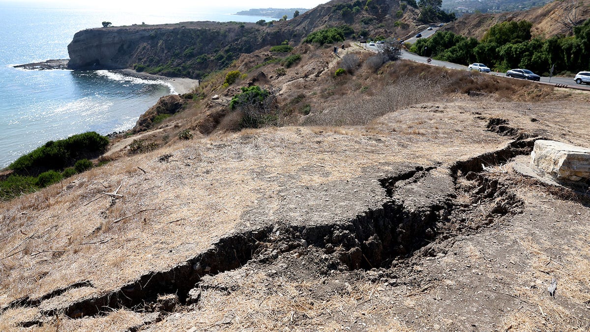
A badly decomposed body was found Saturday in Rancho Palos Verdes. (Wally Skalij/Los Angeles Times via Getty Images)
While the department did not release the manner of death, the case is being investigated by the homicide unit.
Officials told Fox News Digital on Monday the body has yet to be identified.
Anyone with information about the incident is encouraged to contact the Los Angeles County Sheriff’s Department’s Homicide Bureau at (323) 890-5500. To provide information anonymously, tipsters can call Crime Stoppers at (800) 222-TIPS (8477).
Read the full article from Here

Alaska
High winds, freezing rain and heavy snow spread across Alaska

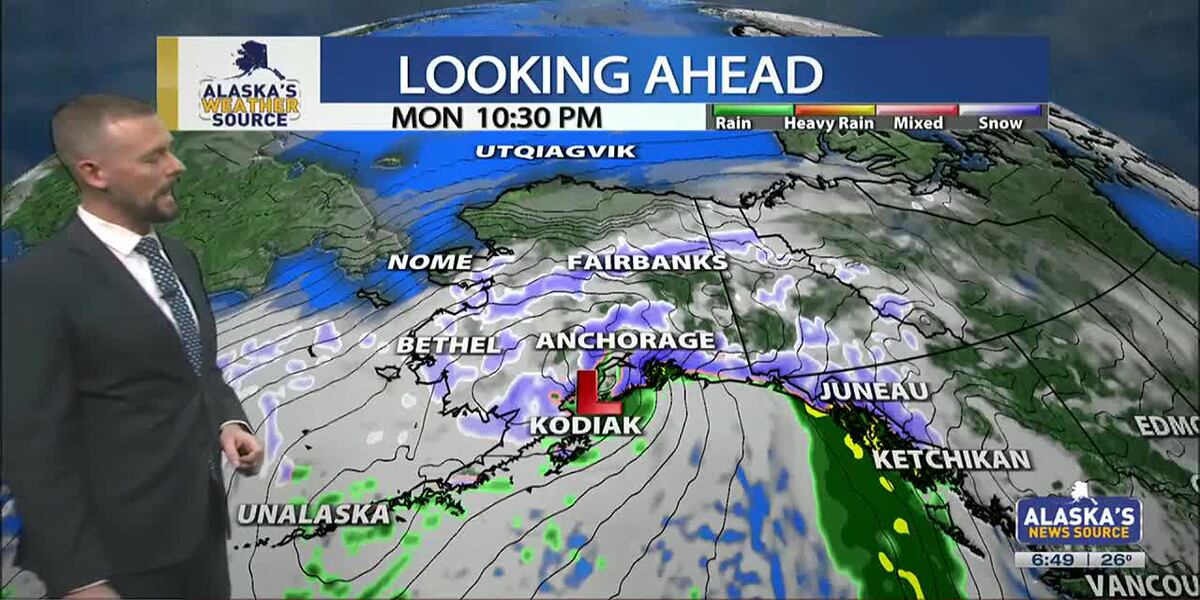
ANCHORAGE, Alaska (KTUU) – Active weather is building back across Alaska with temperatures 10 to 30 degrees warmer than Sunday morning. This stretch of warm and wet weather will remain through the week with high winds impacting areas of Southcentral and the Alaska Range. The strongest winds will occur today (Monday), with winds gusting as high as 85 mph in some of the harder-hit areas.
SOUTHCENTRAL:
Most of Southcentral is waking up to a variety of weather alerts. From high winds to freezing rain, heavy rain to snow, Southcentral will see a mixed bag of precipitation impacting the region. This comes as a strong low moves out of the Northern Pacific Ocean and lifts northward through the Gulf of Alaska.
While the winds are not terribly gusty this morning, expect a gradual increase in winds through the afternoon. The strongest winds will occur through the Matanuska Valley, Anchorage Hillside, Turnagain Arm, Portage and Cordova. These locations can expect to see winds gusting as high as 75 mph, with higher wind gusts along the Anchorage Hillside and through Portage. It’s here where winds could gusts up to 85 mph, with occasional gusts of 100 mph for Portage. Be prepared for possible power outages and downed trees where winds whip the longest.
While the rest of Southcentral won’t see high winds, gusts of 20 to 50 mph still look possible. These winds will be responsible for a quick climb in temperatures today, with all of Southcentral seeing highs climbing above freezing. The potential for highs to climb well into the 40s will occur where winds remain the strongest and mixing occurs. The warmest stretch of weather looks to arrive this evening where the winds will remain the strongest.
In addition to the winds, a mixed bag of precipitation will fall across Southcentral. Expect hazardous roads wherever there is rain and freezing rain.
Rain will largely impact coastal areas, where 2 to 5 inches of accumulation looks likely through the middle of the week. Further inland where temperatures remain below freezing, a mix and/or freezing rain will occur through the first part of the day. Some areas of Southcentral have already seen light rain showers through the night, which led to a coating of ice on windshields left out in the elements. Up to a quarter of an inch of freezing rain is possible for parts of Southcentral, with the best potential for accumulation occurring in the Mat-Su Valley, Anchorage and into the Copper River Basin this evening. Western parts of the Kenai will see the potential for a glaze of ice, before enough warm air moves in to transition to rain.
While freezing rain and winds look to cause concerns for parts of Southcentral, heavy snow will also impact areas of the Copper River Basin and near Thompson Pass. While only 6 to 12 inches looks likely through the Copper River Basin, Thompson Pass could see 2 to 3 feet of snow accumulation. This could change as temperatures continue to steadily warm. Valdez is already sitting at freezing this morning, meaning the city could see more of a rain event, while the pass holds onto heavy wet snow.
Precipitation and winds die down into Tuesday, with only scattered areas remaining. While inland areas remain primarily dry through Wednesday, another storm system looks to arrive later this week. This upcoming storm could once again bring more winds, freezing rain and continued warmth for Southcentral.
SOUTHEAST:
A winter storm warning remains in effect for Skagway, Haines and Klukwan until noon. Two to 4 inches of snow will fall, with winds gusting up to 35 mph. As the snow tapers off, more snow and rain move in through the night. While snow and areas of wintry mix will primarily impact the Northern Panhandle, the rest of Southeast will see wet and windy conditions. As the rain builds in this evening, we’ll see 1 to 2 inches spread across the panhandle.
Active and wet weather looks to remain through much of the week. As a result, expect daily rain and winds will remain in the forecast. While some days will provide some much needed dry time, the overall weather pattern favors wet weather through the end of this week. We’ll see daily highs climbing into the 40s, keeping much of Southeast seeing rain. The only exception will be parts of the Northern Panhandle, where enough cold air remains that we could see pockets of wintry mix.
INTERIOR:
Temperatures in the Interior continue to warm, with many locations seeing highs 20 to 35 degrees warmer than last week. This week will bring very warm conditions to the Interior, with many locations warming into the 10s and 20s. The only exception will be for locations near the Alaska Range (highs expected in the 20s) and the Eastern Interior (highs in the 0s and 10s.).
Areas of the Alaska Range will see gusty winds develop throughout the day and linger through the middle of the week. Winds will gust upwards of 85 mph, with some of the strongest winds occurring north of Trims Camp. In addition to the winds, the Alaska Range will see several inches of snowfall. Blizzard conditions are possible, with 4 to 7 inches of snow accumulation. Most of the snow will fall in the Southern Denali Borough and the Eastern Alaska Range, south of Trims Camp.
While no alerts are in place, snow will also spread north through the Interior this week. Up to an inch of snow, if not slightly more, is expected for the rest of the Interior through the middle of the week. While this shouldn’t lead to any traffic issues, as temperatures warm this week, we could see some slick spots develop across parts of the Interior.
Daily highs for Fairbanks will warm well into the 10s and 20s, with an outside chance we could see a few 30s popping up across the Interior. While the better chance for that will be near the Alaska Range, inland areas of the Interior will also see a stretch of warmer weather.
SLOPE/WESTERN ALASKA:
Cold weather remains for the Slope, with gusty winds expected to stick around through the day. This will lead to some areas of blowing snow and wind chills near -40 in some spots. Strong winds look to impact parts of the Western Brooks Range, where gusts up to 60 to 70 mph look possible. As a result of this, a high wind warning goes into effect later today through Tuesday evening.
While little to no snow is expected for much of the Slope, areas fo the Beaufort Sea Coastline and Arctic Plains could see a few inches of accumulation this evening through Wednesday. 1 to 3 inches looks possible for the immediate coastline, with areas of the Brooks Range seeing 3 to 5 inches. If you’re traveling through Atigun Pass, be prepared for blowing snow and visibility down to half a mile at times.
While things will remain largely dry for Western Alaska, gusty winds will be an issue today. Winds of 30 to 70 mph look possible, with areas of blowing snow leading to reduced visibility. Although not as warm, Western Alaska will see highs today climbing into the 10s. With strong winds sticking around, many areas will see wind chills remain well below zero today.
Through Southwest Alaska, scattered to periodic snow showers look to remain in the forecast. 3 to 6 inches looks to be the best bet for most locations, with the heaviest snow falling from Dillingham, northeast to Koliganek and Stuyahok. While snow looks to be the primary precipitaton today, warmer weather tomorrow could lead to some areas of rain and snow for southwest.
ALEUTIANS:
Light rain showers and winds are impacting the Aleutians this morning, with less than a quarter of an inch for most areas. While some areas of the Alaska Peninsula may see some light snow showers, a warmer push of air will lead to most areas seeing rain in the forecast. We’ll keep with gusty winds and mild temperatures this week, as daily highs warm into the 30s and 40s.
One thing to watch will be increasing winds for parts of St. Lawrence Island and parts of the Bering Sea, where winds will remain quite gusty. Gusts up to 60 mph will be possible, with areas of freezing spray for the Bering Sea, Pribilofs, Nunivak island and areas of St. Lawrence Island.
OUTLOOK AHEAD:
A warmer weather pattern looks to grip much of the state for the next few weeks. Daily highs will likely stay at or above freezing in Southcentral, with the Interior not dropping back below zero until late next week. Numerous storm systems look to take aim on Alaska over the next 2 weeks, with a mixed bag of precipitation to be expected. There’s not good chance of snow in the forecast for Anchorage and surrounding locations. While we could see a brief opportunity for snow over the next week, expect little accumulation if any.
Have a safe and wonderful start to your week.
See a spelling or grammar error? Report it to web@ktuu.com
Copyright 2025 KTUU. All rights reserved.
Arizona
Arizona pastor hid cameras to record women using church bathroom: police

An Arizona pastor was busted for secretly recording videos of women using his church’s bathroom after the camera fell out of a dryer, according to police.
Arturo Laguna, a pastor at the Casa de Adoracion in Phoenix, allegedly installed the recording device in the church bathroom last fall and recorded the women in October and early November, according to a police report obtained by Fox 10 Phoenix.
The perverted preacher was only caught after a mother discovered the camera while changing her baby’s diaper inside of the strip mall church’s women’s bathroom, cops said.
Investigators later found screenshots of Laguna adjusting the camera inside of the bathroom. When police interviewed Laguna, he confessed to having put up the camera in October.
Authorities searched the camera’s SD card and uncovered four short videos of adult women using the bathroom, according to the outlet.
The pastor was arrested in November and charged with multiple counts of voyeurism — a felony in Arizona.
He was indicted last week and is scheduled to appear in court again on Jan. 9.
The Post has reached out to Casa de Adoracion for comment.
In October while he was allegedly filming the women, Laguna, who leads a largely immigrant congregation of about 100 people, spoke to the Associated Press about his faith community and the upcoming 2024 presidential election.
California
California Continues Targeting Food Additives, Dyes With Executive Order on Ultra-Processed Foods

California Governor Gavin Newsom has issued an executive order that mandates state agencies explore the food safety of ultra-processed foods, food dyes, and “generally recognized as safe” (GRAS) ingredients, and recommend actions to mitigate the adverse health effects.
The executive order characterizes ultra-processed foods and ingredients as “industrial formulations of chemically modified substances extracted from foods, along with additives to enhance taste, texture, appearance, and durability, with minimal to no inclusion of whole foods.” Common examples include packaged snacks, chips, crackers, cookies, candy, sugary beverages, and highly processed meats like hot dogs and lunch meats. It also calls attention to the myriad chemicals, such as food colorants, authorized for food use in the U.S., claiming that more than 10,000 such substances are currently present in the U.S. food supply, in comparison to the 300 authorized for use in the EU.
Many food chemicals enter the nation’s food supply through the U.S. Food and Drug Administration’s (FDA’s) GRAS process, which lawmakers and scientists have criticized as a “loophole” allowing potentially toxic additives in food. In a recent article by Harvard medical and law experts, the authors called GRAS a “laissez-faire approach to monitoring the safety of ingredients” that poses a threat to public health.
In this context, California has passed several precedent-setting pieces of state legislation on chemical food additives and colorants in recent years, such as the California Food Safety Act and the California School Food Safety Act.
Continuing state efforts to crack down on chemical food additives, Gov. Newsom’s latest executive order includes, but is not limited to, the following mandates:
- No later than April 1, 2025, the California Department of Public Health (CDPH) will provide recommendations to the Governor’s office regarding potential actions to limit the harms associated with ultra-processed foods and food ingredients that pose a public health risk (e.g., the inclusion of warning labels on certain ultra-processed foods)
- The Office of Environmental Health Hazard Assessment (OEHHA), in consultation with CDPH, will investigate the adverse human health impacts of food dyes, and provide a briefing to the Governor’s office no later than April 1
- No later than April 1, CDPH and OEHHA will report to the Governor’s office on the feasibility of state-level evaluation of food additives considered GRAS, as well as state actions that can be taken if companies fail to notify FDA of certain food additives through the GRAS process
The executive order also includes actions aimed at decreasing the purchase of ultra-processed foods; increasing access to healthy foods; and improving the nutrition of and increasing the amount of fresh, local-grown ingredients used in California school meals.
Some groups have previously criticized California’s approach to food additives regulation for leading the charge on an emerging patchwork of state regulations, however. For example, prior to the passage of the California School Food Safety Act, the Consumer Brands Association (CBA) stated, “[The bill] sets a dangerous precedent for state politicians to substitute their own views on food safety ahead of the scientists and risk-based review system that stringently protects America’s food supply. Americans deserve unified guidance that follows the science, not a patchwork of confusing laws.”
-

 Health1 week ago
New Year life lessons from country star: 'Never forget where you came from'
-
/cdn.vox-cdn.com/uploads/chorus_asset/file/24982514/Quest_3_dock.jpg)
 Technology1 week ago
Technology1 week agoMeta’s ‘software update issue’ has been breaking Quest headsets for weeks
-

 Business5 days ago
These are the top 7 issues facing the struggling restaurant industry in 2025
-

 Culture5 days ago
The 25 worst losses in college football history, including Baylor’s 2024 entry at Colorado
-

 Sports5 days ago
The top out-of-contract players available as free transfers: Kimmich, De Bruyne, Van Dijk…
-

 Politics4 days ago
New Orleans attacker had 'remote detonator' for explosives in French Quarter, Biden says
-

 Politics3 days ago
Carter's judicial picks reshaped the federal bench across the country
-

 Politics2 days ago
Who Are the Recipients of the Presidential Medal of Freedom?


