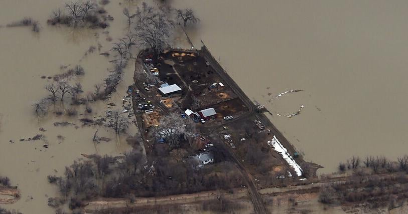
Gov. Greg Gianforte on Tuesday issued a disaster declaration for areas in eastern and south central Montana impacted by runoff-swollen rivers and flooding last month.
The Milk climbed to 27.94 feet at Tampico, just shy of the record of 28 feet set in 2011. Flood stage is 23 feet.
“Runoff from recent rainfall and snowmelt has compromised critical infrastructure and roads in Montana,” Gianforte said in a statement. “This order will help impacted communities rebuild and get back on their feet.”
Meagher, Valley, Hill, Liberty, Blaine, Daniels, and Park Counties, the Fort Belknap Indian Community, the Fort Peck Indian Reservation, and the towns of Glasgow and Nashua enacted emergency or disaster declarations in response to the flooded conditions; several of them reported extensive damage to infrastructure.
The governor’s disaster declaration will allow affected communities to utilize “all necessary state government services, equipment, and suppliers” with goal of furthering “the efforts to protect health and safety and to preserve the lives, property, and resources of the people of the State of Montana.”
People are also reading…
The declaration also frees up the state to “expend funds from the general fund to meet contingencies and needs arising from these conditions” within the affected communities.
The plains snowpack, which typically melts from mid-February into April, is hanging on longer in 2023 and the plains snow last month showed widespread areas of 4-8 inches of snow water equivalent across North Dakota and eastern South Dakota following a blizzard that occurred in late March.
Despite all of the moisture, much of the northern and western regions of Montana are still listed as suffering from moderate drought, with the area along the Milk River listed as suffering from severe drought, according to the U.S. Drought Monitor. In between the north and west are wide swaths of the state still considered abnormally dry.
Runoff into Fort Peck Reservoir from the Missouri River is higher than normal for this time of the year, according to the U.S. Geological Survey’s gauges. The Missouri River at Landusky was flowing at 10,500 cfs, about 2,000 cfs higher than normal.
The Musselshell River — another contributor to Fort Peck Reservoir — was running at 278 cfs, compared to an average flow of 78 cfs. Fort Peck is expected to climb to an elevation of 2,220.8 feet by the end of April, which is the bottom elevation of the Fort Peck Marina’s boat ramp.
The Yellowstone River is seeing a boost from higher than usual flows on the Bighorn, Tongue and Powder rivers. The Yellowstone River at Glendive was reporting 16,200 cfs compared to an average of 7,390 cfs.
A video captured by Beartooth Slingshot Rentals captures devastating aerial footage of the flood roaring through the Red Lodge area.


/cdn.vox-cdn.com/uploads/chorus_asset/file/25742882/DSC_1384_Enhanced_NR.jpg)


/cdn.vox-cdn.com/uploads/chorus_asset/file/24924653/236780_Google_AntiTrust_Trial_Custom_Art_CVirginia__0003_1.png)


/cdn.vox-cdn.com/uploads/chorus_asset/file/25672934/Metaphor_Key_Art_Horizontal.png)
