Alaska
Western Alaska storm and southerly flow drives warmth back into the state

ANCHORAGE, Alaska (KTUU) – Gusty winds and heavy snow has begun to spread into Western and Southwest Alaska, with a surge of warmer air. Temperatures in Southwest Alaska is already 10 to 35 degrees warmer than yesterday morning. This warmth will spread across the rest of the state through the weekend, with some of the most pronounced warmth along the Slope. We’ll see many areas this weekend into next week remaining well-above average.
SOUTHCENTRAL:
Temperatures are slowly warming across Southcentral, with many areas seeing cloud coverage increasing. While we could see some peeks of sunshine today, most locations will see mostly cloudy conditions. While we can’t rule out light flurries for inland locations, most of the precipitation today will occur near the coast. Snow looks to be the primary precipitation type, although later this evening a transition to rain or wintry mix will occur. This comes as temperatures quickly warm across Southcentral.
We’ll see highs today in the upper 20s and lower 30s for inland areas, while coastal regions warm into the 30s and 40s. The southerly flow aloft will remain with us for several days, pumping in the warmth and moisture. As a result, Kodiak could see over an inch of rain today, with gusty winds.
While most of the precipitation this weekend remains near the coast, inland areas will see the best chance for wintry mix Sunday into Monday. Little to no accumulation is expected.
The key takeaways for this weekend, is snow transitioning to rain, with some gusty winds likely for parts of Southcentral this weekend.
SOUTHEAST:
Another fairly quiet day is expected across Southeast today, outside of some light snow near Yakutat. We’ll see a mix of sun and clouds with temperatures remaining on the cooler side. Parts of the Northern Panhandle may stay in the upper 20s today. The stretch of quiet weather will stay with us through the first half of Saturday, followed by an increase in precipitation and winds. This upcoming system may bring some heavy snowfall to Southeast, so be prepared for that potential this weekend. Temperatures warm into next week, back into the upper 30s and lower 40s for many areas.
INTERIOR:
While temperatures this morning have bottomed out as low as -30 near Fort Yukon, temperatures will warm into the weekend. A wind advisory for the Alaska Range goes into effect at 9 Friday morning, where winds up to 60 mph will warm the Interior. Temperatures today for many locations will warm into the single digits, with some of the greatest warming arriving Saturday through next week. It’s likely we’ll spend most of next week with temperatures in the 20s and 30s, with the warmest locations near the Alaska Range. While we will largely stay dry, there is a chance for some light snow arriving Sunday night into Monday.
SLOPE/WESTERN ALASKA:
Temperatures will remain slightly above average for parts of the Slope today, with warming winds to build into the Slope this weekend. This comes as our area of low pressure in the Bering Sea continues to move farther north. Be prepared for gusty easterly winds along the Slope, leading to blowing snow and reduced visibility. We’ll see temperatures quickly warm well above average, with highs climbing into the 20s and 30s along the Slope into next week. While some snow is possible through the weekend, the heaviest activity will occur for the Brooks Range. We’ll see the potential for 4 to 12 inches of snowfall, with the highest amounts occurring along the southern slopes of the Brooks Range near Kobuk Valley. Winds could gusts as high as 45 mph, leading to greatly reduced visibility.
Heavy snow is impacting Western and Southwest Alaska this morning, with winds gusting up to 50 mph. Numerous winter weather alerts, as well as a coastal flood advisory is in effect. The heaviest snow will fall for the Seward Peninsula and east of Norton Sound, where up to a foot or more of snow is to be expected. The heaviest amounts will fall today, with the activity set to lighten up through Sunday. In addition to the snow, gusty winds will lead to areas of blowing snow. Visibility could be reduced down to less than half a mile at times. As southerly flow continues to pump in warmth, we’ll see a transition from snow to rain later today into Saturday for parts of Southwest Alaska.
ALEUTIANS:
Gusty winds and heavy rain will fall through the Aleutians today, where up to .75″ of rain is possible. As the area of low pressure moves north, we’ll see a new low form just south of the Eastern Aleutians. This will lead to additional rain and winds into the weekend. Winds could gusts upwards of 50 mph through the Eastern Aleutians and through the Alaska Peninsula. With ridging to our east, more rain and winds remain with us into early next week. There is the potential that the Pribilof Islands see a return to snow Sunday, as colder air moves into the Bering Sea.
OUTLOOK AHEAD:
Well above average warmth will stay with us as we close out January. While one more short-lived cold snap is possible, we may have to wait until February before we tap into warmer conditions. Temperatures through the close of January will keep average monthly temperatures 5 to 12 degrees above average for much of the state. The overall trend still favors a wetter pattern, although with warmer weather the southern parts of the state will favor more rain or a mixed bag of precipitation.
Have a wonderful and safe holiday weekend.
See a spelling or grammar error? Report it to web@ktuu.com
Copyright 2025 KTUU. All rights reserved.


The Anchorage Daily News caught up with some of the top track and field athletes from around the state at the annual Big C Relays. The list includes a sprinter who likes to play disc golf, a pair of Spider-Man fans, a reigning state champ who can’t get enough Macklemore, and three elite athletes whose biggest influences have been their older brothers. There were also several notable performances by perennial contenders and up-and-coming talent alike.
Here’s an introduction to six track and field athletes and the top performers from the Big C Relays.
Tyce Escott, Soldotna
The Soldotna senior sprinter was the Division I boys state runner-up in the 100 meters in 2025 by 0.01 seconds, and is the reigning state champ in the 200 meters. At the Big C Relays, he competed in the 100 and finished second in the prelims with mark of 11.34 seconds, then finished fourth in the semifinals in a time of 11.37 seconds. Escott helped the Stars Mixed Swedish Medley Relay team come in first place with a time of 2:09.55.
How did you get started in track and field? “I kind of just grew up running and decided to try it as a sport when I got to middle school, and I’ve been doing it ever since.”
What is your favorite hype music genre, song or artist before an event? “I don’t usually listen to music. I’m just in my own head and do what I want to do.”
What is the best movie or series you’ve watched in the past year? “Spider-Man Homecoming.”
Favorite fictional character of all time: “Spider-Man.”
Spider-Man follow-up: Favorite Spider-Man live action actor? “I like the Tom Holland ones the best, but I like Andrew Garfield too.”
Who is the most influential or inspirational person in your life? “I look up to my older brother. He didn’t do track but he always did sports and he was known for being fast. He did football and soccer.”
Goals for this season: “I’m hoping to come back and try to get first (at state in the 100 meters), try to improve as much as I can and do the best to my ability. My goals are to hopefully win state, beat my (personal records) and just do as best as I can.”
What is your favorite non-sports leisure activity? “I play disc golf sometimes. There’s probably three or four (courses) down in Soldotna.”

Anna Green, South
The South Anchorage senior sprinter is the reigning Division I girls state champion in the 200 meters, and she also finished third in the 100 and fourth in the 400 last year at state. At the Big C Relays, she competed in the 100 meters and clocked the top times in the prelims (12.81 seconds) and the semifinals (12.86 seconds). In the finals, she came in third place with a time of 12.83 seconds and also helped the Wolverines finish third in the girls Swedish Medley Relay 1600-meter race with a mark of 4:37.22.
How did you get started in track and field? “My middle school health teacher. I was originally a hurdler and she transitioned me to a sprinter, and I’ve stuck with it ever since.”
What is your favorite hype music genre, song or artist before an event? “Macklemore! Before every race, I listen to him.”
What is the best movie or series you’ve watched in the past year? “‘Prison Break.’ It was just thrilling.”
Favorite fictional character of all time: “Donald Duck. He’s always been my favorite since childhood.”
Who is the most influential or inspirational person in your life? “My dad. He grew up in Australia and ran (track) and played soccer. I played soccer my entire life, and I’m going to run track in college, and he was a big part of that.”
Goals for this season: “I want to (record personal bests), break another school record after I broke the 400 last year and I want to try to defend my 200-meter state title.”
What is your favorite non-sports leisure activity? “Watching movies and hanging out around my house with friends.”

Benjamin Hiestand, Chugiak
The Chugiak junior thrower is the Division I boys state champion in discus and came in fourth in the shot put at state last year. At the Big C Relays, he competed in the shot put and discus, setting a new personal best in the shot with a first-place mark of 50 feet, 3.25 inches Friday. He came back on Saturday and recorded the top mark in the discus as well, 161 feet, 1 inch.
How did you get started in track and field? “My brother (Edward). I always followed what he did when I was younger so in the third grade, I did sprints because I was just following him and then he transitioned to throws, so that’s what started getting me into throws too.”
What is your favorite hype music genre, song or artist before an event? “I usually do no music so I can stay locked in and just focus.”
What is the best movie or series you’ve watched in the past year? “My favorite show is ‘Avatar: The Last Airbender’ and for movie series it’s ‘Ip Man’ for the martial arts and John Wick.”
Favorite fictional character of all time: “Zuko from ‘Avatar: The Last Airbender.’ I just like his story of how he kind of redeemed himself at the end. He showed a lot of growth.”
Who is the most influential or inspirational person in your life? “My brother. He taught me a lot and I was really thankful to have him growing up as an example.”
Goals for this season: “This season, I’ve been seeing massive breakthroughs in both shotput and discus and I’m ready to really see what I can do. … Last year I kind of ran into a slump in shot put and I didn’t really improve at all from freshman year, but this year I’ve been really hammering down on the rotational form and I’ve been seeing breakthroughs in that, and I’m really starting to feel comfortable with the rotational form.”
What is your favorite non-sports leisure activity? “Just exploring and driving around and playing video games.”

Bella Connally, Juneau-Douglas
The Juneau-Douglas sophomore sprinter is the reigning Division I girls state champion in the 100 meters and came in fifth in the 200 meters. At the Big C Relays, she competed in the 100 meters, finishing fourth in the prelims with mark of 13.03 seconds, second in the semifinals in a time of 12.90 seconds and first in the finals in a time of 12.68 seconds. She earned the title of Fastest Alaskan on the girls side.
How did you get started in track and field? “My brother. He did track and field and I saw him running all the time and I was like, ‘Whoa, that looks really cool,’ and I thought I’d be good at that too.”
What is your favorite hype music genre, song or artist before an event? “I like to listen to Frank Ocean. I like to get in my feelings and stuff. I can’t do hype music.”
What is the best movie or series you’ve watched in the past year? “‘Modern Family’ and ‘The Office.’”
Favorite fictional character of all time: “I love ‘Spider-Man.’ The Tom Holland one is my favorite.”
Who is the most influential or inspirational person in your life? “My brother.”
Goals for this season: “I’d really like to run a (personal record), I’d like to qualify for Nike Nationals, to win state again. That’d be really cool.”
What is your favorite non-sports leisure activity? “I like to do ceramics. I have a class in my high school for it, so basically every day.”

Joshua Woko, Mountain City Christian Academy
The senior from Mountain City Christian Academy was Division II boys state runner-up in the triple jump in 2025 by about an inch, placed fifth in the long jump and was part of the state champion 4×400 relay team. At the Big C Relays, he competed in long jump and recorded the second-best mark with a new personal best of 20 feet, 8.75 inches on his first attempt, and he recorded the fifth-best mark in the high jump with 5 feet, 2 inches. He also helped the Lions Mixed Swedish Medley Relay team come in fifth place with a time of 2:19.50.
How did you get started in track and field? “I started my sophomore year. It was something I was kind of debating if I should do, but I was told, ‘Just try it out,’ and when I tried it out, I saw I was good at it and I decided to do it.”
What is your favorite hype music genre, song or artist before an event? “Rap music. Kendrick and Don Toliver.”
What is the best movie or series you’ve watched in the past year? “I’m into anime, so probably ‘Jujutsu Kaisen.’ I like the energy that each character has and the bosses they have to fight.”
Who is the most influential or inspirational person in your life? “Definitely my uncle. He’s my pastor and he’s also my spiritual leader, so he helps me with life struggles, shows me the right path to take, and he’s my counselor.”
Goals for this season: “I’m trying to make sure I do my best this year because I only have one last chance. … Try to (do well) in the 400 again and then get 43 (feet) for triple (jump) and at least 21 or 22 for long jump.”
What is your favorite non-sports leisure activity? “I love watching shows, and I also love to play games like chess, and I also draw a lot.”

Ailafo Fautanu, Dimond
The Dimond junior thrower was the Division I girls state runner-up in the shot put in 2025 and placed third in the discus. At the Big C Relays, she competed in the discus and produced the fourth-best mark at 99 feet, 6 inches, and came back on Saturday and recorded the third-best mark in the shot put with a mark of 33 feet, 9.25 inches.
How did you get started in track and field? “With volleyball being my main sport, I just thought, ‘Why not fill my free time with track and field?’ and it was really fun for me and I really liked the experience, so I just decided to keep going at it.”
What is your favorite hype music genre, song or artist before an event? “No, I’m just locked in.”
What is the best movie or series you’ve watched in the past year? “‘The Miracle Season.’ I just like how the girls had something to motivate them and push them through the season and win their state championship. It’s a volleyball movie.”
Favorite fictional character of all time: “SpongeBob.”
Who is the most influential or inspirational person in your life? “My mom. She’s been a really good role model for me, she’s a hard worker, takes time out of the day to support her kids, even when she’s busy.”
Goals for this season: “Hopefully win a state championship but first reach my goals of (setting a new personal record).”
What is your favorite non-sports leisure activity? “I like skiing and going hiking. I like to hike every once in a while to get in shape and stay in shape. I like to go on sunset drives to unwind from stressful weeks.”

Top performances
Nevaeh Watkins, a Dimond junior and reigning Division I girls 100-meter hurdles and high jump state champion, had quite the first day of action at the Big C Relays. She started by setting a new meet record for the high jump with a first-place mark of 5 feet, 2 inches, and followed it up by recording the fastest time in the 100-meter hurdle prelims and semifinals, which included a new personal best of 15.25 seconds in the semis.
Seward senior and reigning Division II boys state high jump champion Olin Liljemark was the only jumper to clear 6 feet in the event on Friday, which bested his title-winning mark of 5 feet, 10 inches from last year.
Mountain City Christian senior thrower Jieaya Siatini, who is the three-time Division II shot put state champion and reigning discus state champion, won the girls discus by a wide margin. Her mark of 128 feet, 4 inches was more than 23 feet farther than second-place finisher Mattelyn Elliott of Colony (105 feet). Siatini won the girls shot put as well with a mark of 39 feet, 10.75 inches. Runner-up Lilly Davidge, a Lathrop senior, recorded a mark of 33 feet, 11.5 inches.
Chugiak senior distance runner Hannah Shaha successfully defended her Big C title in the 3,200-meter race with a time of 11:53.92, which edged out Eagle River’s Ashlyn Paynter, who came in second at 11:56.32. Shaha, the 2023 Cross Country Gatorade Player of the Year, is also the reigning Division I girls state champion in the same event.
West Valley senior Cedar Robichaud outpaced Chugiak sophomore Frederick Millen III in the boys 100-meter finals with a first-place time of 11.26 seconds to earn the title of Fastest Alaskan.
The Chugiak quartet of Luke Poland, Ahmir Walker, Elijah Udall and Frederick Millen III set a new meet record in the boys 4×100 meter race with a first-place time of 43.44 seconds, besting the previous record of 43.74.

Big C Relays
Girls
100 Meters Varsity – Finals
1. Bella Connally 12.68, Juneau-Douglas
2. Sophia Jedlicki 12.77, Soldotna
3. Anna Green 12.83, South
4. Sienna Johnson 13.04, Chugiak
5. Farrah Gamechuk 13.18, Bartlett
6. Taylor Eddington 13.22, Tri-Valley
100 Meters Pentathlon – Finals
1. Iris Haas 13.04, Delta Junction
2. Caroline Klebs 13.69, Grace Christian
3. Katie Mackin 14.07, Bartlett
4. Kathryn DeBardelaben 14.17, Soldotna
5. Hannah Bodkin 14.21, Chugiak
6. Mari Ward 15.38, Holy Rosary Academy
200 Meters Varsity – Finals
1. Taylor Eddington 26.49, Tri-Valley
2. Farrah Gamechuk 26.92, Bartlett
3. Leila Petersen 27.17, Palmer
4. Shiloh Zichko 27.44, Soldotna
5. Annelise Larsen 27.53, Colony
6. Evonna Council 28.18, East
400 Meters Varsity – Finals
1. Kendall Barnett 1:00.07, West
2. Ellie Stull 1:00.52, Dimond
3. Leila Petersen 1:01.06, Palmer
4. Petra Knox 1:01.33, Chugiak
5. Olivia Sandoval 1:01.43, Chugiak
6. Tagan Rinner 1:01.64, Grace Christian
1 Mile Varsity – Finals
1. Kendall Barnett 5:09.70, West
2. Maddison Kukuk 5:26.60, Chugiak
3. Hannah Shaha 5:33.40, Chugiak
4. Kyra Walter 5:35.18, Chugiak
5. Fiona Selvik 5:35.79, Service
6. Ashlyn Paynter 5:40.80, Eagle River
3200 Meters Varsity – Finals
1. Hannah Shaha 11:53.92, Chugiak
2. Ashlyn Paynter 11:56.32, Eagle River
3. Maddison Kukuk 11:56.57, Chugiak
4. Kyra Walter 12:05.25, Chugiak
5. Rylee Ruggles 12:15.38, Chugiak
6. Myra Kalafut 13:05.23, Homer
100m Hurdles – 33″ / 0.838m Varsity – Finals
1. Nevaeh Watkins 15.14, Dimond
2. Emilia Zych 16.25, Service
3. Emma Mersdorf 17.21, Mountain City Christian Academy
4. Sienna Johnson 17.72, Chugiak
5. Jewel Gardner 17.79, Wasilla
6. Kelsey Momblow 18.12, Eagle River
300m Hurdles – 30″ / 0.762m Varsity – Finals
1. Taylor Eddington 46.44, Tri-Valley
2. Emilia Zych 47.74, Service
3. Katrina Baisa 50.70, Kodiak
4. Mia Bukala 51.41, Redington
5. Jewel Gardner 51.51, Wasilla
6. Vera Bates 51.52, Homer
300m Hurdles – 30″ / 0.762m Pentathlon – Finals
1. Iris Haas 49.26, Delta Junction
2. Hannah Bodkin 51.58, Chugiak
3. Kathryn DeBardelaben 52.34, Soldotna
4. Caroline Klebs 53.28, Grace Christian
5. Katie Mackin 53.45, Bartlett
6. Mari Ward 59.90a, Holy Rosary Academy
4×100 Relay Varsity – Finals
1. Tri-Valley 51.74
2. Soldotna 51.78
3. Dimond 52.00
4. South 53.15
5. Bartlett 53.64
6. Service 53.83
4×800 Relay Varsity – Finals
1. Chugiak 10:00.64
2. Soldotna 10:33.53
3. Grace Christian 10:58.86
4. Homer 11:03.64
5. Service 11:08.30
6. Su Valley 11:09.36
SMR 1600m – (200-200-400-800) Varsity – Finals
1. Dimond 4:19.43
2. Chugiak 4:30.85
3. South 4:37.22
4. Soldotna 4:39.24
5. Homer 4:47.17
6. Service 4:53.56
DMR 4000m – (1,200-400-800-1,600) Varsity – Finals
1. West 13:57.66
2. Soldotna 14:03.47
3. Service 14:21.92
4. Dimond 14:31.34
5. Su Valley 15:00.59
6. Wasilla 15:01.49
Shot Put – 4kg Pentathlon – Finals
1. Kathryn DeBardelaben 26′ 2″, Soldotna
2. Hannah Bodkin 25′ 9″, Chugiak
3. Iris Haas 22′ 11″, Delta Junction
4. Mari Ward 21′ 6″, Holy Rosary Academy
5. Katie Mackin 20′ 2″, Bartlett
6. Caroline Klebs 18′ 7″, Grace Christian
Shot Put – 4kg Varsity – Finals
1. Jieaya Siatini Williams 39′ 10.75″, Mountain City Christian Academy
2. Lilly Davidge 33′ 11.5″, Lathrop
3. Ailafo Fautanu 33′ 9.25″, Dimond
4. Emilee Anderson 33′ 7″, South
5. Loseli Ofiu 32′ 7.5″, West
6. Juliet Innes 32′ 4″, Soldotna
Discus – 1kg Varsity – Finals
1. Jieaya Siatini Williams 128′ 4″, Mountain City Christian Academy
2. Mattelyn Elliott 105′ 0″, Colony
3. Emilee Anderson 100′ 0″, South
4. Ailafo Fautanu 99′ 6″, Dimond
5. Mia Christensen 98′ 7″, Wasilla
6. Dayten VanOstrand 93′ 1″, Homer
High Jump Varsity – Finals
1. Nevaeh Watkins 5′ 2″, Dimond
2. Jessie Wentworth 5′ 0″, Su Valley
3. Autumn Larson 4′ 10″, Chugiak
4. Halie Sandstrom 4′ 10″, Colony
5. Jase Emerson 4′ 10″, Service
6. Maura McDaniel 4′ 8″, Su Valley
High Jump Pentathlon – Finals
1. Hannah Bodkin 4′ 6″, Chugiak
2. Iris Haas 4′ 4″, Delta Junction
3. Kathryn DeBardelaben 4′ 4″, Soldotna
4. Caroline Klebs 4′ 4″, Grace Christian
5. Katie Mackin 4′ 0″, Bartlett
6. Mari Ward 3′ 10″, Holy Rosary Academy
Long Jump Varsity – Finals
1. Rachael White 15′ 11.5″, South
2. Emilia Zych 15′ 8″, Service
3. Reilly Sue Baker 15′ 7″, Homer
4. Darby D’Amico 15′ 6.25″, South
5. Caroline Klebs 15′ 3.25″, Grace Christian
6. Grayson Henry 15′ 3″, Soldotna
Boys
100 Meters Varsity – Finals
1. Cedar Robichaud 11.26, West Valley
2. Frederick Millen III 11.29, Chugiak
3. Abubacar Marenah 11.40, West
4. Christopher Casey 11.43, West
5. Elijah Udall 11.67, Chugiak
6. Luke Poland 12.13, Chugiak
100 Meters Pentathlon – Finals
1. William Klein 11.93, Soldotna
2. Liam Pettit 12.03, Mountain City Christian Academy
3. Calvin Musgrave 12.07, Wasilla
4. Johannes Bynagle 12.41, Homer
5. Chris Jones 12.58 Grace Christian
6. Gideon Bedingfield 12.72, Su Valley
200 Meters Varsity – Finals
1. Cedar Robichaud 22.83, West Valley
2. Frederick Millen III 22.86, Chugiak
3. Ahmir Walker 22.90, Chugiak
4. Matthew Varney 23.13, Chugiak
5. Elijah Udall 23.38, Chugiak
6. Chrystchen Font 23.49, Service
400 Meters Varsity – Finals
1. Matthew Varney 50.73, Chugiak
2. Jack Weiss 51.50, Dimond
3. Ahmir Walker 51.51, Chugiak
4.Travis Saari 52.28, Colony
5. Reubin Williams 52.54, Service
6. Ansel Alexander 52.56, West
800 Meters Pentathlon – Finals
1. Johannes Bynagle 2:05.54, Homer
2. Liam Pettit 2:17.57, Mountain City Christian Academy
3. Gideon Bedingfield 2:18.49, Su Valley
4. Chris Jones 2:19.12, Grace Christian
5. Calvin Musgrave 2:29.08, Wasilla
6. William Klein 2:29.82, Soldotna
1 Mile Varsity – Finals
1. Arlo Jespersen 4:36.22, West
2. Kohen Galloway 4:37.53, Chugiak
3. Weston Roberts 4:38.00, Kodiak
4. Jai Badajos 4:41.57, Homer
5. Breyden Nottingham 4:44.08, Mountain City Christian Academy
6. Atlin Frederick 4:48.38, West
3200 Meters Varsity – Finals
1. Weston Roberts 10:01.27. Kodiak
2. Breyden Nottingham 10:05.74, Mountain City Christian Academy
3. Henry Pysher 10:07.41, Kodiak
4. Kohen Galloway 10:08.49, Chugiak
5. Joseph Laudermilch 10:10.90, Birchwood Christian
6. Josiah Herrick 10:11.54, Colony
110m Hurdles – 39″ / 0.991m Varsity – Finals
1. Matthew Jackson 15.29, East
2. Malachi Coski 16.58, Dimond
3. Tait Ostrom 16.64, Homer
4. Chris Jones 16.98, Grace Christian
5. Brandt Rollman 17.50, Cook Inlet Academy
6. Ethan Parker 17.72, Mountain City Christian Academy
300m Hurdles – 36″ / 0.914m Varsity – Finals
1. Christian Enriquez 43.64, Kodiak
2. Jayden Yeager 43.67, Soldotna
3. Elijah Johnson 44.49, North Pole
4. Adrienne Wales 44.90, Bartlett
5. Lucas Starck 45.01, West
6. Hunter Davis 45.81, Service
300m Hurdles – 36″ / 0.914m Pentathlon – Finals
1. Liam Pettit 43.92, Mountain City Christian Academy
2. Chris Jones 44.02, Grace Christian
3. Johannes Bynagle 45.35, Homer
4. William Klein 45.41, Soldotna
5. Calvin Musgrave 46.39, Wasilla
6. Gideon Bedingfield 47.74, Su Valley
4×100 Relay Varsity – Finals
1. Chugiak 43.44
2. Grace Christian 45.85
3. Palmer 45.94
4. Soldotna 45.99
5. Service 46.05
6. Bartlett 46.07
4×800 Relay Varsity – Finals
1. Soldotna 8:39.55
2. Kodiak 8:42.88
3. Mountain City Christian Academy 8:53.99
4. Valdez 8:54.57
5. Eagle River 8:55.46
6. Grace Christian 8:56.20
SMR 1600m – (200-200-400-800) Varsity – Finals
1. Dimond 3:43.67
2. Homer 3:49.04
3. Colony 3:49.16
4. Chugiak 3:50.21
5. Soldotna 3:53.95
6. Mountain City Christian Academy 3:53.97
DMR 4000m – (1,200-400-800-1,600) Varsity – Finals
1. West 11:07.81
2. Kodiak 11:25.56
3. Homer 11:29.80
4. Soldotna 11:33.77
5. Service 11:43.26
6. West Valley 11:45.33
Shot Put – 12lb Varsity – Finals
1. Benjamin Hiestand 50′ 3.25″, Chugiak
2. Theo Huff 47′ 2″, Soldotna
3. Grant Ousley 45′ 9″, Colony
4. Tino Timu 44′ 9.75″, Kodiak
5. Kyle Petersen 44′ 5″, Valdez
6. Ryvre Howell 42′ 9″, Chugiak
Shot Put – 12lb Pentathlon – Finals
1. Liam Pettit 40′ 1″, Mountain City Christian Academy
2. Johannes Bynagle 38′ 8″, Homer
3. William Klein 33′ 2″, Soldotna
4. Chris Jones 32′ 9″, Grace Christian
5. Calvin Musgrave 32′ 2″, Wasilla
6. Gideon Bedingfield 28′ 8″, Su Valley
Discus – 1.6kg Varsity – Finals
1. Benjamin Hiestand 161′ 1″, Chugiak
2. Nolan Garner 133′ 8″, Palmer
3. Theo Huff 132′ 1″, Soldotna
4. Curtis Forbes 129′ 1″, Lathrop
5. Grant Ousley 123′ 0″, Colony
6. Matthew Innes 121′ 4″, Soldotna
High Jump Varsity – Finals
1. Olin Liljemark 6′ 0″, Seward
2. Triton Ellis 5′ 8″, Colony
3. Ryan Gossett 5′ 6″, Su Valley
3. Julian Kiefer 5′ 6″, Kodiak
5. Christian Enriquez 5′ 6″, Kodiak
6. Corde Bates 5′ 4″, Dimond
6. Corbin Gerkin 5′ 4″, Palmer
High Jump Pentathlon – Finals
1. Johannes Bynagle 6′ 0″, Homer
2. Chris Jones 5′ 2″, Grace Christian
2. Gideon Bedingfield 5′ 2″, Su Valley
2. Calvin Musgrave 5′ 2″, Wasilla
5. Liam Pettit 5′ 2″, Mountain City Christian Academy
6. William Klein 5′ 0″, Soldotna
Long Jump Varsity – Finals
1. Corde Bates 20′ 9″, Dimond
2. Joshua Woko 20′ 8.75″, Mountain City Christian Academy
3. Wilson Lawson 20′ 3.5″, Lathrop
4. Ashton Clarkson 19′ 5.75″, Grace Christian
5. Triton Ellis 19′ 2.75″, Colony
6. Corbin Gerkin 19′ 1.75″, Palmer
Mixed Results
Mixed Swedish 100-200-300-400m Varsity – Finals
1. Soldotna 2:09.55
2. Dimond 2:12.88
3. West Valley 2:15.46
4. Kodiak 2:17.39
5. Mountain City Christian Academy 2:19.50
6. West 2:19.80

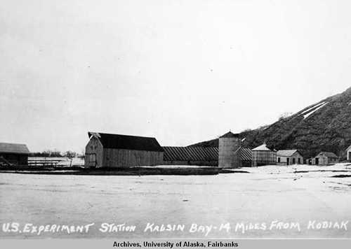 On this day in 1898, the United States Department of Agriculture would open an experimental station on Kodiak Island to experiment with cattle breeding.
The station, authorized by the 1887 Hatch Act, would open in Kalsin Bay, 14 miles to the south of present-day Kodiak
The station’s initial mission was to assess the adaptability of Galloway cattle to the island’s conditions. Different hay grains were also experimented with.
Later, Sitka Black-tailed Deer and Roosevelt Elk would be introduced to the station, deer in 1900 and elk in 1928. While initially the elk were to be released on Kodiak Island, it was determined that the possibility of competition with the cattle for winter food meant that they would instead be introduced to Afognak Island to the north.
The Kalsin Bay Station was one of several that would be established throughout Alaska.

MANLEY HOT SPRINGS — It’s so quiet in these spruce hills and tamarack swamps that 27 hours and 50 miles passed between when Forest Wagner and I said goodbye to one human being at Old Minto and hello to the next near Baker.
Space is in ample supply here on these pressed-in snow trails between towns and villages of Interior Alaska.
Forest and I are out here riding these ephemeral ribbons of blue-white moving westward, with a goal of reaching Nome.
Last Saturday, when it warmed to minus 12 degrees Fahrenheit, I lurched my loaded fat bike out of my home in Fairbanks. Saying goodbye to my wife and dogs, I rumbled eastward on a boot-packed trail that after a mile led to a plowed bike path. I then rolled through the familiar University of Alaska Fairbanks campus and onward 8 miles to Forest’s cabin.
He handed me a mug of coffee and an egg sandwich. Then we started pedaling our fat bikes down Chena Pump Road until we reached the Tanana River.

We found a trail groomed for a multi-sport winter race, turned right, and headed downstream on our home river, there half a mile wide. It was a day when the weather finally nodded toward spring. Fair-a-dise showed up with bluebird skies as the day warmed to 8 degrees Fahrenheit.
After a month of pillowy snows and crazy cold temperatures and re-telling people our new takeoff days to semi-suppressed eye rolls, we were finally unstuck from the glue of town.
If an object wasn’t hanging off our bikes, we didn’t need it. No more fiddling with the load or obsessing on the 7-day weather forecast. Just big ol’ tires humming on dry snow.
Now, five days and 145 miles later, Forest and I are digesting French toast and bacon our friend Steve O’Brien cooked for us as we wait on the dryer in the Manley washeteria. When we get a few dollar bills we will take showers.

It’s a good life here on the trail, just-add-water living at its finest. Eat everything in front of you, apply some sunblock and keep mashing on the pedals.
Steve O’Brien is one of the many people helping us move westward. In one of the most clutch moments, my wife Kristen and our friend Jen Wenrick appeared wearing headlamps on the packed snow ramp off the Tanana River in Nenana. They handed us burgers and fries from the Monderosa.
After a surprise tough day due to soft trail that had us working real hard, those burgers and Cokes were like oxygen.
There have been many other acts of kindness from Jenna and David Jonas, Steve Ketzler, Forest’s dad Joe Wagner and others. Tonic for the body and soul.

We will meet more excellent people, including some old friends, as we ratchet toward Nome.
When my satellite tracker is on, you can see our arrow creeping across the landscape here: https://share.garmin.com/NedRozell.

Second-annual Rhododendron Roll brings thousands to West Virginia State Capitol

Wyoming Has Half Of The West’s 26 100-Year-Old Dude Ranches
Is Crypto Legal in Norway? EY Explains the Regulations

Car finance saga: Millions of motorists to find out how they will be compensated

Does Medicare Help Pay for Gym Memberships?

Florida High School Football Rankings: Top 25 teams – Oct. 21

How old is Bo Nix? What to know about Oregon quarterback ahead of 2024 NFL Draft

Cleary's 21 help Le Moyne down Central Connecticut State 69-64 in OT

99th annual Pony Swim held in Virginia

Indiana Members Credit Union announced as new anchor tenant at Bottleworks District

JD Vance says he was ‘obsessed’ with UFOs, believes aliens are actually ‘demons’
The EU's recipe for trade deals : easy on beef, tough on wine

Photos: ‘No Kings’ protests across the country

Jeffries declines to break with indicted Democrat after ethics panel’s guilty verdict

Hundreds of thousands march through London in stand against the far right
-

 Sports1 week ago
IOC addresses execution of 19-year-old Iranian wrestler Saleh Mohammadi
-

 New Mexico6 days ago
Clovis shooting leaves one dead, four injured
-

 Tennessee6 days ago
Tennessee Police Investigating Alleged Assault Involving ‘Reacher’ Star Alan Ritchson
-

 Technology7 days ago
YouTube job scam text: How to spot it fast
-

 Minneapolis, MN3 days ago
Boy who shielded classmate during school shooting receives Medal of Honor
-

 Science1 week ago
Record Heat Meets a Major Snow Drought Across the West
-

 Texas1 week ago
How to buy Houston vs. Texas A&M 2026 March Madness tickets
-

 Politics1 week ago
Schumer gambit fails as DHS shutdown hits 36 days and airport lines grow