Pittsburg, PA
It’s going to be a clear day in the Pittsburgh area before rain moves back into the forecast tomorrow

PITTSBURGH (KDKA) — It’s going to be a clear day in the Pittsburgh area with rain chances moving back into the forecast tomorrow.
We’ve technically already reached today’s high temperature (57 degrees) just after the midnight hour or so. Cooler—but not cold—air is moving in behind this morning’s cold front and will result in slightly cooler afternoon temperatures, although with mostly sunny skies, it should still be an overall comfortable day with afternoon temperatures peaking in the lower 50s to upper 40s.

Overnight into Wednesday morning, temperatures will drop to the low 30s for most and at the present moment, temperatures may stay around or just above freezing in Pittsburgh thanks to a light southeast wind and clouds that will move in to the region toward daybreak.
Clouds will increase through the morning Wednesday with another round of rain showers by afternoon and evening as another trough of low pressure passes through the region. This system will not get much stronger until it passes east of us and the precipitation will end before the coldest air settles in, so wintry precipitation is not a major factor for Wednesday night into Thursday outside of a brief period of some snow north of Rt. 422 toward I-80 for an hour or two on the back end of the rain by early evening Wednesday.

Most spots will receive around 0.25″ with a few locations possibly near 0.5″, especially closer to I-70 and I-68. Models may be overdoing the precipitation quantity with this system given how fast it is moving and how little time it will have to draw up moisture from the southwest.
Expect temperatures to continue to drop each day this week, ultimately reaching below average levels by the end of the upcoming week. Another trough of low pressure will swing in from the northwest on Friday bringing another chance for a few snow showers along with another surge of cold air. As the cold air continues to flow over Lake Erie, that could keep lake effect snow showers and flurries through Saturday before the coldest of the air settles in with high pressure by Sunday. Although Sunday will be the coldest day of the week, models have backed off a few degrees on the lowest of the low temperatures.

This cold air will likely stick around until early next week before a warmer pattern sets in around and especially after Christmas, so for anyone looking for a big snow—your probability is trending lower and lower.
WEATHER LINKS:
Current Conditions | School Closings & Delays | Submit Your Weather Photos


Got story updates? Submit your updates here. ›
Wabtec Corporation, a leading transportation technology company, has announced that it will release its first quarter 2026 financial results on Friday, April 25, 2026. The company will host a conference call the same day to discuss the results with investors and analysts.
Why it matters
As a major player in the transportation industry, Wabtec’s quarterly earnings provide insight into the overall health and performance of the sector. The company’s results are closely watched by investors and industry analysts to gauge trends and outlook.
The details
Wabtec, which stands for Westinghouse Air Brake Technologies Corporation, is a global provider of equipment, systems, digital solutions, and value-added services for the freight and transit rail industries. The company’s products are used on virtually every class of locomotive, freight car, passenger transit vehicle, and specialty rail equipment in service worldwide.
- Wabtec will release its Q1 2026 financial results on Friday, April 25, 2026.
- The company will host a conference call the same day to discuss the results.
The players
Wabtec Corporation
A leading global provider of transportation technology equipment, systems, and services for the freight and transit rail industries.
Got photos? Submit your photos here. ›
What’s next
Investors and analysts will be closely watching Wabtec’s Q1 2026 earnings report for signs of how the transportation industry is performing and any insights into the company’s future outlook.
The takeaway
Wabtec’s quarterly earnings are an important barometer for the overall health of the transportation technology sector, providing valuable data points for investors and industry observers.
Pittsburg, PA
The Future is Growing at Phipps Conservatory and Botanical Gardens | Pittsburgh Magazine

PHOTO BY BECKY THURNER BRADDOCK
Richard Piacentini, president and CEO of Phipps Conservatory and Botanical Gardens, will never forget his initial glimpse of the grand, glass venue as he rounded the corner in Oakland on his way there for a job interview in 1993.
“I was totally blown away,” he recalls. “From that moment on, I wanted that job.”
At the time, he was serving as executive director of Leila Arboretum in Battle Creek, Mich., and wasn’t seeking a new position. Yet when he received a call from the head of Phipps’s search committee, he became intrigued.
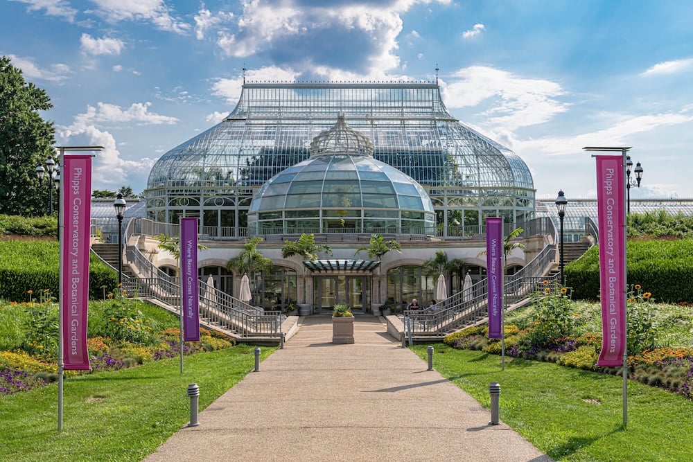
PHOTO BY PAUL WIEGMAN
The New York native had never heard of Phipps, which surprised him as someone incredibly active in the botanical garden world. He quickly learned that, while many folks in Pittsburgh cherish this institution, those in the greater botanical garden world weren’t in the know about Phipps — yet.
Piacentini arrived in 1994, almost a year after Phipps had transitioned from city to private, non-profit management (known as Phipps Conservatory, Inc.). There had been an interim manager before he arrived. Around that same time, the Pittsburgh Zoo, Aviary and Citiparks also shifted to nonprofit status.
During that original interview, the search committee expressed great interest in Phipps remaining a typical botanical garden, according to Piacentini. And it wasn’t long before Piacentini’s conversations with Pittsburghers crystalized how families here treasure their personal, multi-generational history.
As he soon discovered, Phipps holds a pivotal place in locals’ hearts due to childhood excursions with parents and grandparents.
“You cherish those memories,” Piacentini says. “It’s ingrained in a lot of people’s minds.”

PHOTO BY PAUL WIEGMAN
He decided it would be a big mistake to get rid of the venue’s beloved flower shows. Instead, Piacentini saw the need to encourage attendance at the conservatory throughout the entire year. While still keeping the shows, Phipps has since greatly expanded its offerings.
By 1997, the motto “Something’s always blooming at Phipps” took flight — a promise of enticing programming in any season. Today, the verdant property encompasses 15 acres, including a 14-room glasshouse and 23 distinct gardens.
Beyond the ever-changing seasonal flower displays, Phipps is home to permanent collections that showcase orchids and ferns, palms and cacti. Loyal fans covet the vibrant Spring Flower Shows, renowned bonsai collections and modern traditions such as the glowing Winter Light Garden.
The venue also prides itself on educational programming for all ages, with the goal to inspire in fields such as gardening, botanical craft, healthy living and the culinary arts.
With Piacentini’s arrival, Phipps changed how its exhibits were installed, too. Before, a couple-week gap may have lingered between shows, often leaving spaces empty. (Piacentini even remembers guests asking for their money back.) Now, visitors can experience the flower exhibits while in progress.
“How fun is that?” Piacentini says. “We really changed the whole concept and mentality.”
When Piacentini began there, the venue received about 110,000 visitors a year; they now get more than 450,000 annually. He emphasizes the uniqueness of the offerings, since only a few conservatories in the country do flower shows like Phipps — one other being Longwood Gardens in Eastern Pennsylvania.

PHOTO BY PAUL WIEGMAN
Honoring History, Changing with the Times
The venue has been an important local landmark since 1893, when Henry Phipps presented Phipps Conservatory as a gift to the city. His initial aim was to “erect something that will prove to be a source of instruction as well as pleasure to the people.”
Ever since, visitors have been welcomed to the Schenley Park oasis. Throughout the decades, it’s remained a destination where folks can connect with nature and find a respite from city pollution — something especially desired during the Industrial Revolution.
Yet while holding onto its treasured history, the conservatory is constantly being reinvented. Market research showed that Phipps needed to focus on improving visitor services, so administrators began a multi-phase expansion after Piacentini’s 1994 arrival. At the time, the Welcome Center didn’t have a cafe or gift shop, but it was clear people wanted on-site options for both.
“We realized if we wanted to be the kind of place that draws people from outside the region, we needed to increase visitor stay time,” Piacentini says.
Prior to the addition of the Tropical Forest Conservatory, many visitors remained on property for an hour or less. (Research studies have suggested that guests need to stay for a minimum of 1.5 hours to be satisfied.) What nobody realized, however, was that the expansion project would ultimately transform the conservatory into an internationally recognized leader in sustainability.
In a letter celebrating “125 years of wonder,” Piacentini wrote, “But even as we broke ground on this complex of revolutionary buildings — including the first LEED-certified visitor center in a public garden, a Tropical Forest Conservatory that eliminates the greenhouse effect, the world’s only LEED Platinum-certified Production Greenhouses and one of the greenest buildings in the world, the Center for Sustainable Landscapes — the melding of instruction and pleasure has remained at the core.”

PHOTO BY PAUL WIEGMAN
Going Green
Over time, climate change has become an increasing concern and focus at Phipps. Piacentini notes that, when this venue was developed in 1893, people had very different mindsets, as many believed they were going to “conquer” nature.
The focus on sustainability — now a crucial Phipps pillar — didn’t emerge until officials started considering the master plan for the future. In the process of interviewing architects for the Tropical Forest Conservatory, the venue’s leaders talked to Bill McDonough, who introduced them to a then-new certification program called LEED.
They realized if they truly cared about the environment, their actions and designs must align with their values. In 2003, work began on the new Welcome Center; it opened in 2005. The LEED-certified building features an inviting beacon of warmth, Dale Chihuly’s Goldenrod, Teal and Citron Chandelier, which was designed and created exclusively for Phipps.
The year 2006 introduced both the Production Greenhouse and Tropical Forest Conservatory, a multi-level exhibit with exotic plants, rushing waterfalls and a tranquil fish pond that made its debut as the most energy-efficient structure of its kind. Every three years, it showcases a different part of the world, and experiences no greenhouse effect, thanks to elements such as high-efficiency, double-pane glass, six underground earth tubes, and a radical roof design where half can open.
When designing the Production Greenhouse, staff and board members were told they couldn’t get a greenhouse LEED-certified. The team later went back and got it deemed Platinum in 2012 under the LEED-EBOM (Existing Buildings Operation and Maintenance) rating system. It took a few years to identify other greenhouses for a comparative study in order to prove their greenhouses were much more efficient.
Piacentini says the Phipps team has “upped the ante” with each new development. On the lower campus alone, they’ve erected three zero-energy buildings: the Center for Sustainable Landscapes, opened in 2012; the Nature Lab at Phipps, opened in 2015; and the Exhibit Staging Center, opened in 2019.

PHOTO BY PAUL WIEGMAN
Current + Future Endeavors
In discussing their most meaningful accomplishments, Piacentini highlights the complete renovation of the original conservatory to make it look as it did back in 1893. This includes the replacement of the ogee (the distinctive architectural molding and arch curve formation) at the top of the Victorian-inspired Palm Court, which had been missing since a devastating storm in 1938.
Phipps has now turned its attention to the glasshouse decarbonization project, which will transform the glasshouse and additional facilities into a net-zero energy campus powered by 100% renewable energy while simultaneously preserving the historic character of the building. The project will serve as a global model for others wanting to retrofit historic structures — and inspire large institutions to transition from fossil fuels.
“It’s the biggest challenge yet, but we’re very excited,” Piacentini says. “We have a plan, and we think we can do it.”
Last spring, Phipps announced it had acquired the former Irish Centre site in Squirrel Hill. Although the project is still pending funding — and is contingent on the timing of the nearby Commercial Street Bridge demolition over the summer — it is intended to be used for the growth of both plants and communities.
The satellite site will serve as headquarters for Phipps’ Homegrown program, an incubator for new community greening projects that has expanded to more than 250 city-wide gardens (primarily in areas without access to fresh food), a nursery for plants for upcoming flower shows and a laboratory for research projects. Over time, Phipps plans to transform the property into a green building as well.
Piacentini also is proud of the Sustainable Landcare Program, developed to teach landscapers how to care for properties without the use of toxic chemicals.
“This is very important for people with children and grandchildren, in addition to schools, daycares and others,” he says.
Leaving a Better World
Phipps’ leaders seem to understand that humans are naturally compelled to understand and protect the things they find beautiful. In this way, they see how a place like Phipps can “help demonstrate important lessons about how to live, work and build in harmony with the natural world.” They’re happy to share knowledge gained along the way.
In 2019, Phipps created The Climate Toolkit — a collaborative program for museums, gardens, zoos, science centers, nature centers, field stations and related institutions that also want to learn how to “aggressively address climate change.” Since its inception, the initiative has grown to reach 254 institutions in 30 different countries; they’ve even started one for nonprofits in Pittsburgh.
Of all the team’s accomplishments at Phipps, Piacentini says, “the most exciting thing is the mindset we’ve been able to develop.”
He credits regenerative thinking as the single most important reason they’ve been able to build some of the greenest buildings in the world. In using regenerative systems-based nested thinking, he explains, “We see ourselves in relation to everything in nature.”
This means working to enhance the whole versus isolated components, ensuring that human and environmental health are prioritized over profit, and understanding that success needs to be measured in the long term.
Throughout Phipps’ many evolutions as one of the city’s most generous gifts, the venue’s leaders have never lost sight of its true purpose: connecting people to nature.
“We’re still doing the same, but seeing it from different angles 130 years later,” Piacentini says. “I think we’re really lucky to have Phipps here in Pittsburgh.”

PITTSBURGH — The Pittsburgh Steelers are likely one of the teams that will be heavily considering a wide receiver when it comes to their very valuable first-round pick in the 2026 NFL Draft.
One of the top options, and considered by many analysts to be the best overall, is Ohio State Buckeye alum Carnell Tate. Tate is a three-year starter at Ohio State, and the top wide receiver selection is likely to be between him and Arizona State’s Jordyn Tyson.
While at Ohio State, Tate was a teammate of current Steelers backup quarterback Will Howard, and was asked about him during his workout at Ohio State’s Pro Day.
“Oh, Will isn’t giving me no tips. He’s probably going to root for me to come with him to Pittsburgh,” Tate said.
“I’m happy for him. I wish him nothing but the best. Love that guy to death,” Tate also said.
Howard would not be the first person to try to get their former teammate to join them from college to their professional team, with one big example being Derek Carr and Davante Adams a couple years prior.
If Tate were to join the Steelers, he would be the third member of the 2024 Ohio State National Championship-winning team to play for the Steelers simultaneously, with Howard and surging young linebacker Jack Sawyer having played on the Steelers in 2025.
Will Tate Go To Pittsburgh?
Tate is quite unlikely to end up with the Steelers, as he is expected to be among the first players selected in the 2026 NFL Draft. With the Steelers having the No. 21 selection, they would need to make a significant trade forward to likely jump into the zone where Tate would be available.
“I think I’m a great football player,” Tate said about going into the NFL. “My speed … the combine is one time, but ultimately I’m a great football player. When you put the pads on, it’s another level.”
They could probably do that, due to the fact that they have 12 selections across the seven rounds. At this point in time, it does not see they love any particular player enough to make that big of a trade up, but trades into the late end of the top ten are quite common. Yet, their move to land Michael Pittman Jr. would make it significantly less likely that they make such a move to get another wide receiver.
While at Ohio State, Tate was always in the top half of their wide receiver room, yet played among some of the most talented wide receivers in recent history in current NFL player Emeka Egbuka and young talent Jeremiah Smith. He finished his final collegiate season with All-Big Ten honors, as well as well as being a second team All-American.
Subscribe to our FREE Newsletter for the latest news and updates on the Pittsburgh Steelers

Milwaukee police search for suspect after fatal shooting near 105th and Villa

Good Day Atlanta viewer information: March 30, 2026

Minneapolis Parks Equity Plan Ahead of Schedule 2026

HBCU All-Star Experience takes over Indianapolis – Indianapolis Recorder

Wabtec Announces First Quarter 2026 Earnings Release Date – Today in Pittsburgh

Florida High School Football Rankings: Top 25 teams – Oct. 21

How old is Bo Nix? What to know about Oregon quarterback ahead of 2024 NFL Draft

Cleary's 21 help Le Moyne down Central Connecticut State 69-64 in OT

99th annual Pony Swim held in Virginia

Indiana Members Credit Union announced as new anchor tenant at Bottleworks District

Video: Iran to Allow More Oil Ships Through Strait of Hormuz, Trump Says

Dem senator warns deportation could let Virginia woman’s illegal immigrant killer ‘escape accountability’

Newsletter: G7 ministers to hold talks on war’s economic fallout

ICE officers could remain at airports after TSA workers are paid

Scathing report claims nation’s oldest labor union ‘betrayed’ MAGA members through ‘shocking’ spending
-

 Sports1 week ago
IOC addresses execution of 19-year-old Iranian wrestler Saleh Mohammadi
-

 Miami, FL4 days ago
Jannik Sinner’s Girlfriend Laila Hasanovic Stuns in Ab-Revealing Post Amid Miami Open
-

 New Mexico1 week ago
Clovis shooting leaves one dead, four injured
-

 Politics1 week ago
Schumer gambit fails as DHS shutdown hits 36 days and airport lines grow
-

 Tennessee7 days ago
Tennessee Police Investigating Alleged Assault Involving ‘Reacher’ Star Alan Ritchson
-

 Minneapolis, MN4 days ago
Boy who shielded classmate during school shooting receives Medal of Honor
-

 Science1 week ago
Record Heat Meets a Major Snow Drought Across the West
-

 Politics1 week ago
Trump gives Iran 48-hour ultimatum to reopen Strait of Hormuz or face strikes on power plants