Wyoming
Lawmaker: Northern Wyoming dam cost ‘close to not making sense’

By Angus M. Thuermer Jr.
The increased cost of the proposed Alkali Dam near Hyattville has rendered the project “close to not making sense,” the speaker of the Wyoming House told state water developers earlier this year.
Rep. Albert Sommers (R-Pinedale) made that assessment May 8 after hearing that the estimate to build the 100-foot high, half-mile long earthen structure is now $113 million. That’s more than three times the $35 million cost estimated in 2017.
The Alkali Dam would impound 6,000 acre feet of water that would be used by 33 irrigators for late-season irrigation of 13,000 acres. Wyoming would lend the benefitted landowners a total of $2.1 million and pay for the rest.
The Wyoming Water Development Office, which is designing the project for a private irrigation district, is having difficulty justifying the expense.
“I think it’s important to try to understand the price of what we’re doing, because, ultimately, that comes back to the cost-benefit ratio,” Sommers said at the meeting.
Cost-benefit rules govern how much the state can pay.
“I’m all for doing water projects,” Sommers said. “But it’s got to make sense in the end, too. And this is getting dangerously close to not making sense.”
$127 million above estimates
Alkali Creek is one of two proposed Big Horn County dams whose original cost estimates are now collectively about $127 million off-base. The Upper Leavitt Reservoir expansion is estimated to cost $89 million, up from the original $39.8 million.
The state outlines what “makes sense,” as Sommers put it, in its criteria for funding reservoirs. The Wyoming Water Development Commission can give grants “for the full cost of the storage capacity [of any given reservoir] but not to exceed public benefits as computed by the commission.”
As computed in May “the public benefits [amount to] only $104 [million]-$105 million,” for the now-$113 million Alkali Creek project, Water Development Office Director Jason Mead told lawmakers and water commission members.
The cost-benefit ratio could be improved if some of the project’s costs are attributed to elements other than the irrigation supply itself, according to discussions at the meeting.
A principal example is the $30 million cost of converting a ditch that would fill the reservoir into a buried pipeline. “Should [$30 million] be attributed to the project — raising the cost and putting the public-benefit ratio at risk — or counted as mitigation?” Mead asked as he outlined potential accounting options.
Another way of improving the cost-benefit ratio would be to attribute more value to benefits, irrigators said. The Water Development Commission should be liberal in its assessment of public benefits, including birdwatching, irrigators said.
That could be tricky.
“I understand there’s things we can’t necessarily quantify — birdwatching and things like that,” Mead said. “We can always get creative on those things. We’re just trying to be consistent with how we’ve looked at other projects.”
To reduce state costs, Wyoming sought but failed to get a federal grant to fund part of the development. The Bureau of Reclamation rejected the request “because of concerns with economics,” among other things, Derrick Thompson, an engineer with consultant Trihydro, told the panel.
Undeterred, Wyoming is seeking another federal grant from funds earmarked for a “watershed protection and flood prevention program,” he said. It’s uncertain whether an irrigation project would qualify for the program, let alone prevail in a competitive application process, Thompson said.
Cecil Mullins’ vision
For years, Worland native and irrigator Cecil Richard Mullins watched the nearby Nowood River, fed by runoff from the Bridger and Bighorn mountains, swell in the spring and dry up in the fall. In 2007, he “wanted to figure out a way where we could capture that early spring runoff and actually put it to use when the river went dry,” Mead told the panel.
Mead met Mullins and his fellow irrigators and told them it would cost $1,000 to apply for a state-funded watershed study, a necessary beginning for any reservoir construction.
“Everybody was pulling out $20 bills by the time we got done to come up with $1,000,” Mead said of the meeting.

Mullins died in 2019, but his $20 investment has grown. “We’ve spent probably $5 million over the last however many years it’s been — since 2010 — to get to this point,” Mead told the panel.
“We’re about 50% into the design,” he said, “and needing to acquire easements.”
But landowners on whose property various ditches, canals, pipelines or the reservoir itself would lie have asked for design changes — like the $30 million ditch-to-pipeline conversion.
Landowners at the upper end of the reservoir are also worried about public use of the reservoir near their property. Therefore developers would build an embankment to impound a small pool at that end of the reservoir.
The pool would provide “some additional benefits to those landowners to offset some of the impacts,” Trihydro’s Thompson said. Yet “we’re still struggling to come to agreements with many of the landowners,” his Trihydro colleague, Mark Donner, said.
Irrigators’ share
Inflation, geologic surprises, lighter-than-expected embankment material and the design changes add to costs. But irrigators have not pledged to pay more than their $2.1 million loan.
“That’s what everybody voted on,” said John Joyce, an irrigation district member. “The operating costs are starting to mount here,” he said, ticking off maintenance, annual rent for federal property and other things.
“I’m not saying it can’t be higher,” he said of irrigators’ contributions, increasing the debt would require a vote among district irrigators that hasn’t been proposed.
Water Development Commission Vice Chair Lee Craig told irrigators the state will do “everything we can to try to help you.
“But there’s certain things we can’t do or certain things that you guys will have to do,” Craig said. “And hopefully, working together, we can get through this.”
This article was originally published by WyoFile and is republished here with permission. WyoFile is an independent nonprofit news organization focused on Wyoming people, places and policy.

CODY— A Wyoming archaeologist is speaking out against vandalism of petroglyphs in Bighorn Basin.
Bonnie Lawrence-Smith, president of the Wyoming Association of Professional Archaeologists, said she often sees signs of vandalism near the petroglyphs, such as bullet holes and new engravings.
Watch the report below:
‘Hurts my heart’: Wyoming archaeologist speaks out against petroglyph vandalism
She estimates some the petroglyphs, left by Indigenous Peoples, date back to thousands of years old.
“People have been shooting at these panels for probably decades,” said Lawrence-Smith. “It’s just unfortunate that people think that it’s okay to erase someone else’s heritage.”
Vanessa Willardson/Q2
Other petroglyphs have chalk drawn over them and man-made pecking marks.
“Prior to better education, people would… come out and they would take a piece of chalk, and they would outline the petroglyph because it makes it easier to see in photographs… not understanding the damage that they were doing,” said Lawrence-Smith. “So that’s unintentional vandalism.”
Lawrence-Smith showed MTN a site where many names and dates were scratched onto the surface of the rock panel.
“It hurts my heart,” she said.
Vanessa Willardson/Q2
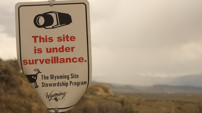
The site is one of six sites the Bureau of Land Management is investigating for vandalism.
According to a recent BLM press release, another site was damaged from a bonfire, “resulting in discoloration, cracking, and the loss of rock fragments”.
Lawrence-Smith said she wants more people to face criminal charges for vandalism.
“They need to understand that there are repercussions for your actions,” she said.
Vanessa Willardson/Q2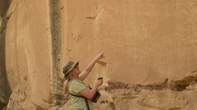
She told MTN she would like to see more participation in the Wyoming Site Stewardship Program.
“You can volunteer, and you can monitor sites,” said Lawrence-Smith. “And then you also have a better timeline of when vandalism does occur.”
Vanessa Willardson/Q2
Even though many sites contain vandalism, Lawrence-Smith has noticed it has decreased over the years.
“What I’ve seen in my 16 years, vandalism is on the downside,” she said. “I’m optimistic. I think they’re getting better.”
BLM encourages people who witness vandalism of rock art sites to leave tips at their Cody Field Office phone number, 307-578-5900.

Rodeo champion Rusty Wright’s big comeback didn’t start with a wild bronc or record-setting ride. It began between rides, in the dust and noise of Cheyenne Frontier Days when a stranger asked him to do a quick interview for a documentary about barrel racing legend Angela Ganter.
They wanted him to talk about something he feels strongly about — the importance of women in the rodeo world.
“I’ve got a pretty strong opinion about it, so I figured I’d go ahead and do it,” said the saddle bronc champ. “I didn’t expect it to be as big of a deal as it turned out being. I was passionate about it, and they loved that, so I think the interview went a little longer than it was supposed to.”
His off-the-cuff, passionate interview would become what Wyoming filmmaker Raen LeVell describes as the “beating heart” of his “Outriding the Devil,” a film he believes is well on its way to becoming a grassroots rodeo blockbuster.
It’s enjoyed a multi-week run as the No. 1-ranked Western documentary on IMDb and earned major praise from national outlets like Sports Illustrated.
It’s also gained elite backing from professional rodeo leaders, who have given it prime screenings at some of the sport’s biggest venues, including the National Finals Rodeo.
Women Behind Rodeo’s Biggest Champions
Ask Wright who the real heroes of rodeo are, and he’ll point first to the women — those who compete in the arena and the ones who never step inside of it.
In his Cheyenne interview, he poured his heart out about his own mother, ShaRee Wright, and all of the other rodeo moms and wives who help keep riders like himself going.
“They asked me what my mom meant to me, and the things she’s done for me in my career,” he said. “Everybody hears how our dad helped us along. He gets lots of recognition, which he should.
“But I don’t feel like my mom or the wives behind the scenes ever really get the recognition they deserve. Honestly, I think it should be just as much as what my dad would get.”
If there were gold buckles for “backbone of the family,” Rusty said he’s convinced his mom would have several of those.
The deep respect for women behind the chutes is exactly the kind of authenticity LeVell was hoping to capture in his film, from Ganter’s story to the moms and wives behind the scenes.
Ganter’s ‘Red Devil’ Comeback
“Outriding the Devil” focuses on the little-told comeback story of Ganter, a barrel racer whose stunning career slammed into a stage-four breast cancer diagnosis so advanced doctors told her she was unlikely to live.
But Ganter had always been a fighter and refused to give up.
The chemotherapy that ultimately saved her has a telling nickname, though. It’s called the “red devil,” and it wreaks havoc on the human body in its quest to ultimately save it.
There were days Ganter couldn’t walk from her bedroom to the living room. After chemo like that, almost no one believed Ganter would even be able to ride a horse again, much less fight her way back to compete at an elite level.
“That red devil chemo had road-graded her nervous system,” LeVell said. “She had lost her balance. She didn’t really know left from right. So the idea that she would get on a horse and be able to just kind of like work on a horse was a little fanciful, and the thought that she would come back to rodeo was kind of like Disney-line stuff.”
And yet, Ganter not only survived, but she returned to rodeo at the highest levels, finding a special horse named Bugs and clawing her way back to champion-caliber barrel racing.
Lighting A Fire Under Rusty Wright’s Comeback
For Wright, who hadn’t known the full depth of Ganter’s ordeal until that Cheyenne interview, her resilience ended up lighting a fire right when he needed it most.
“When I did that interview, honestly, I was kind of right in the middle of my own personal issues and stuff,” he said. “I went from, you know, top of the world — I was reserve world champion in 2018 — and then I had a bunch of personal struggles. I wasn’t even making finals one year. I wasn’t even top 50.”
Learning what Ganter had overcome helped him push the reset button.
“You start playing the ‘poor me’ game, and if you open your eyes and look around, everyone’s got something,” he said. “You sitting there crying about your problems, that isn’t going to help you get out of them.
“A lot of people have it a lot worse off than I do, and they made it. They conquered it. So that kind of lit that fire under me to get my stuff together, and you know, set my goals, realign my priorities, and away we went.”

From NFR To Wyoming
After its premiere at the National Finals Rodeo in Las Vegas — the Super Bowl of Western sports — “Outriding the Devil” has hit the rodeo trail. That’s included premiering at major Texas events like RodeoHouston and the San Angelo Stock Show & Rodeo.
Now after making waves on a national stage, the film is circling back to where Rusty’s turning point began — Wyoming. The film will have an especially long runway in the Cowboy State with several free premieres ahead.
It will open the College National Finals Rodeo in Casper on June 13, making it one of the rare films to both premiere as an official event of the NFR and later open the college finals as well.
From there, it heads to Sheridan for the WYO Rodeo kickoff on July 5 and then to Cheyenne Frontier Days, where it will premiere July 16.
All of these shows will be free to the public thanks to Visit Casper, the Wyoming Foundation for Cancer Care, the WYO Rodeo, and the Gold Buckle Club.
These Wyoming events will also be the last chances to see “Outriding the Devil” on the big screen, and they’ll include opportunities to quiz the director and rodeo figures after the show.
Streaming deals are being negotiated for a wider, national release, but premiere-style events will end once those begin.
-

“Outriding the Devil” Director Raen Le Vell with “Yellowstone” actor Mo Brings Plenty. (Courtesy Photo) -
Included in “Outriding the Devil” are, from left, Stetson Wright, Rusty Wright, Sha Ree Wright, Lily Wright, Angela Ganter and Jackie Ganter. (Courtesy Photo) -
Barrel racing legend Angela Ganter and her battle from near death to elite competition is highlighted in “Outriding the Devil.” (Courtesy Photo)


True Meaning Of Grit
The Wright family is considered rodeo royalty by many, and has been an integral part of “Outriding the Devil,” LeVell said.
During the Las Vegas premiere, the Wrights were there in force alongside country music stars and “Yellowstone” actors, including Mo Brings Plenty.
One of those stars was Ned LeDoux, who plays a young Ganter’s uncle in the movie opposite Lily Wright, who is Stetson Wright’s sister.
In the film, Rusty’s brother, Stetson Wright, takes viewers inside the chute as he walks through his mental processes before a ride.
Rusty, meanwhile, talks about the importance of family sticking together and why he sees rodeo as “one big family.”
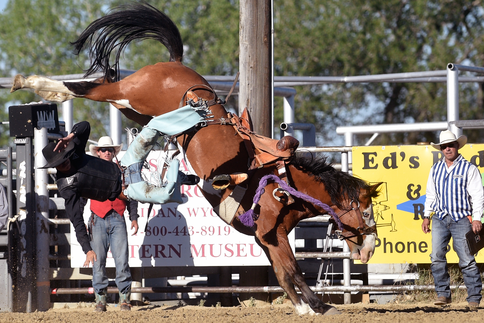
Rodeo is one of America’s most dangerous and physically demanding sports. It takes a certain mindset to keep going, one that’s hard to sustain without family and friends backing it up.
“Everybody always sees our highlights and our wins on social media,” he said. “Everyone talks about our wins and yeah, that’s inspiring and everything. But to me the real inspiration, what gets me fired up, is seeing people’s struggles and what they had to go through to get there.”
Rusty said it took 50-some horses before he could stay on a bronc at all, and probably 300 horses before it finally started to click.
“I remember that moment when it finally clicked for me and I thought, ‘Oh, that’s how it’s supposed to feel,’” he said. “If people could watch how many dirt naps and how many wrecks I got in getting to where I’m at, I guarantee you, most people would be like, ‘I can’t believe he’s still riding.’”
By showing those struggles, Rusty hopes his own kids will realize that whatever they want to do in life, they can do it.
“It doesn’t matter what you’ve been through, or what you go through,” he said. “If you work at it, buckle down, if you stay hooked, you can get your way to the top.”
That’s the larger message he sees in Ganter’s story, too, and it’s one he absorbed thanks to a random interview request at Cheyenne Frontier Days in Wyoming.
“I don’t really believe in coincidences,” he said. “I believe in faith. I was just walking by, and they’re like, ‘Hey, you want to come do this interview?’ God knew I needed that. He knew I needed to hear something, to give me that little push I needed.”
Now that push is on a much bigger stage, playing out in rodeo arenas and theaters across Wyoming and the West — an audience full of cowboys and cowgirls who know exactly what it means to get bucked off hard, dust off, and stand back up again in the arena.
It’s no surprise that such a film would have a Wyoming director behind it, or that it would find its biggest runway in the Cowboy State, where grit has become part of the local DNA.
Renée Jean can be reached at renee@cowboystatedaily.com.

Several local cowboys and cowgirls competed in the Wyoming High School State Finals at the Johnson County Fairgrounds in Buffalo Friday, June 5, 2026. This was fourth performance of the three-day event.
Photos by Clint Wood


-
 News6 minutes ago
The red state, blue state divide is real. But it’s driven by more than just politics
-
 Live on ,000 a Year in the Bronx")
 Live on ,000 a Year in the Bronx") New York1 hour ago
New York1 hour agoHow a Family of 4 (and One Kid in College) Live on $85,000 a Year in the Bronx
-

 Los Angeles, Ca1 hour ago
Los Angeles church fire forces firefighters into defensive mode
-

 Detroit, MI2 hours ago
Detroit’s Inbolt Launches Vision-enabled Robot Programming
-

 San Francisco, CA2 hours ago
These are California’s treasured views: Stunning scenic spots to visit
-

 Dallas, TX2 hours ago
One World One Game: A Cultural Preview for FIFA 2026 – Dallas Weekly
-

 Miami, FL2 hours ago
WPLG Local 10 Becomes the Home of the Miami HEAT
-

 Boston, MA2 hours ago
World Cup 2026 travel guide: Boston

