Nevada
Trip Report: 11,161' Mt. Scowden's “Dog Leg Chute” | Sierra Nevada Mountains, CA – SnowBrains

Report from May 15, 2024
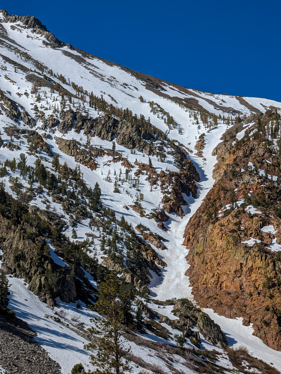
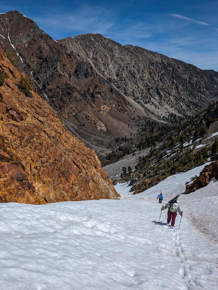
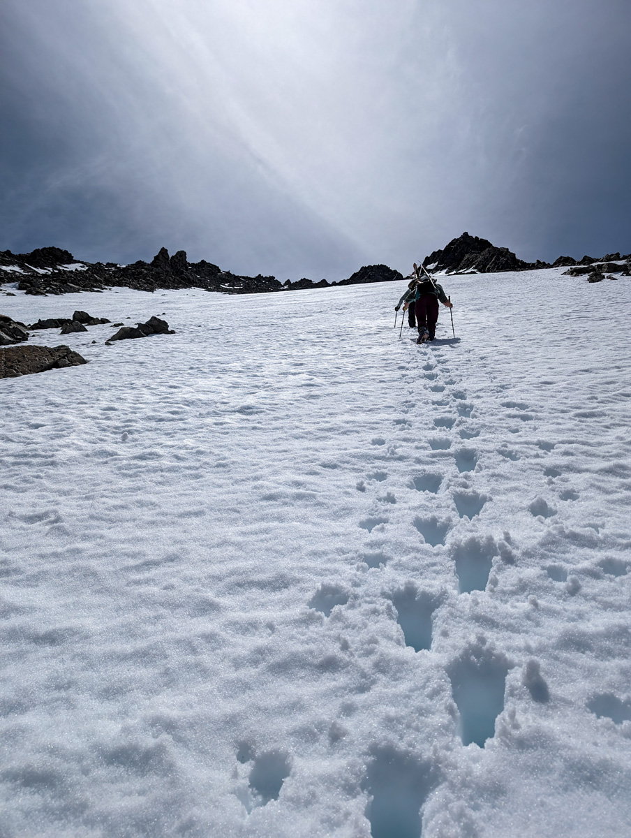
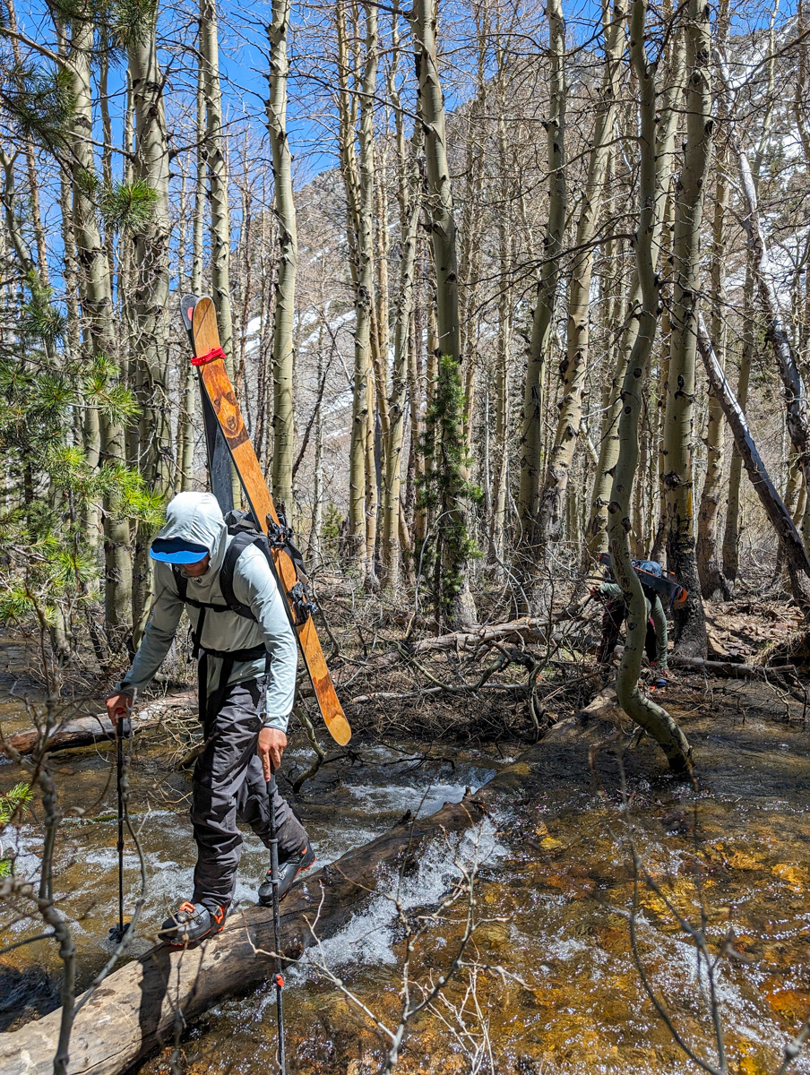
Yesterday we went back to Lundy Lake in the Eastern Sierra Nevada Mountains of California hoping to find more corn as we did in that zone 2 days prior.
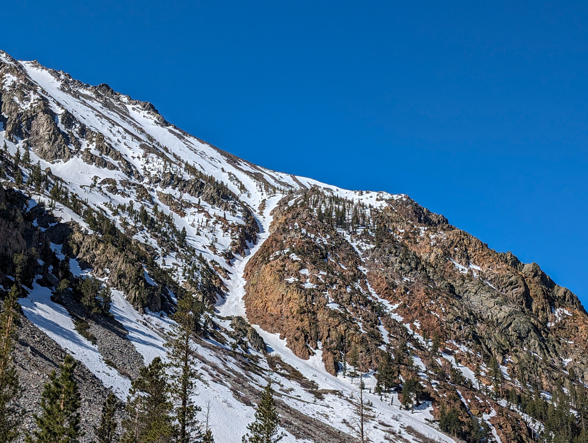
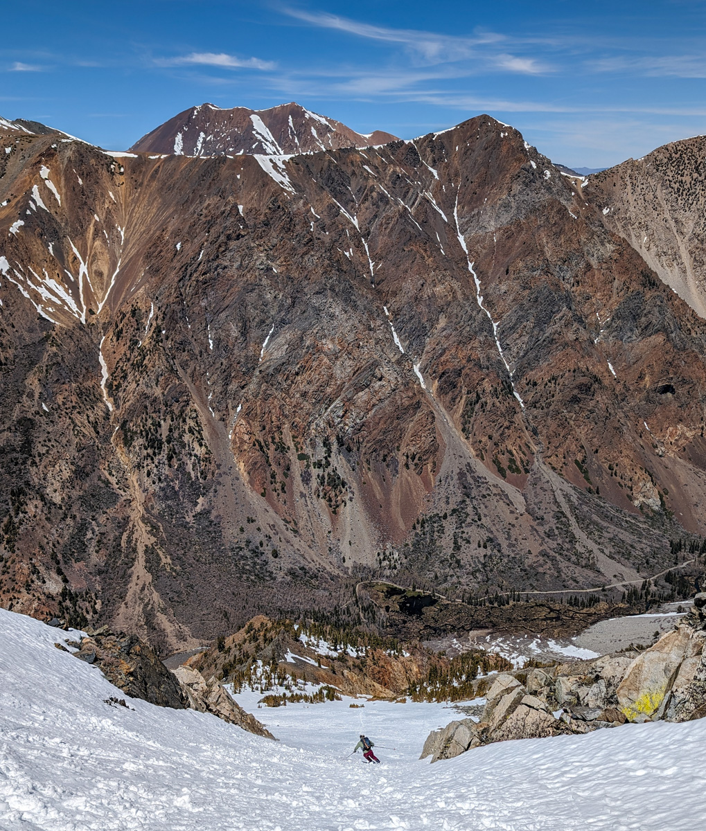
We chose one of the north-facing couloirs off Scowden but it looked beat up with old wet slides.
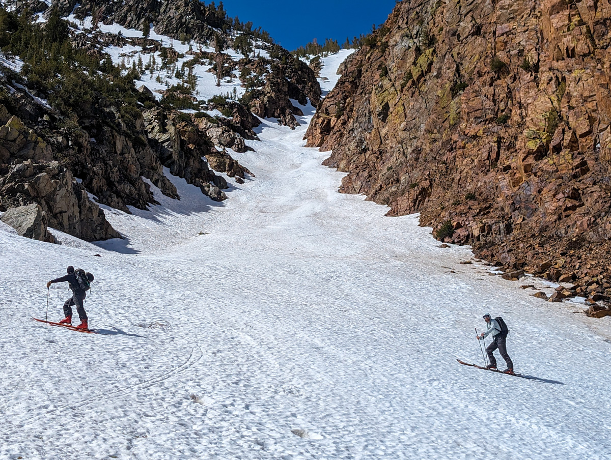
We then bumped over to the “Dog Leg Chute” and started grinding.
- Summit (actually just the top of the snow in the chute): 10,900 feet
- Car: 8,100 feet
- Vertical From Car: 2,800 feet
- Vertical skied: 2,800 feet
- Max Pitch: 38º
- Average Pitch: 35º
- Aspect: North then northeast
- Distance: 2.9-miles round trip
- Time From Car to Summit: 2 hours and 55 minutes
- Car to Car Time: 4 hours and 28 minutes
- Recommended Equipment: skins, crampons, ice axe x2

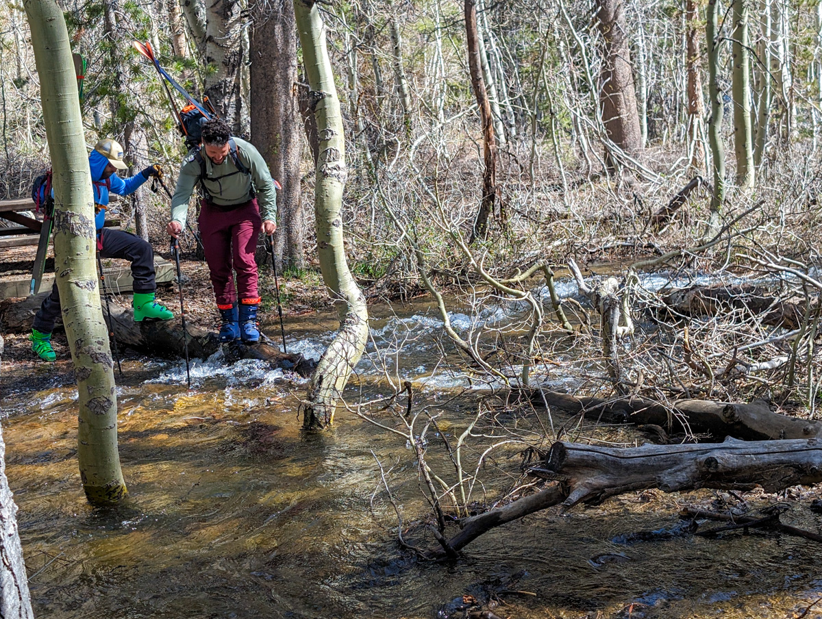
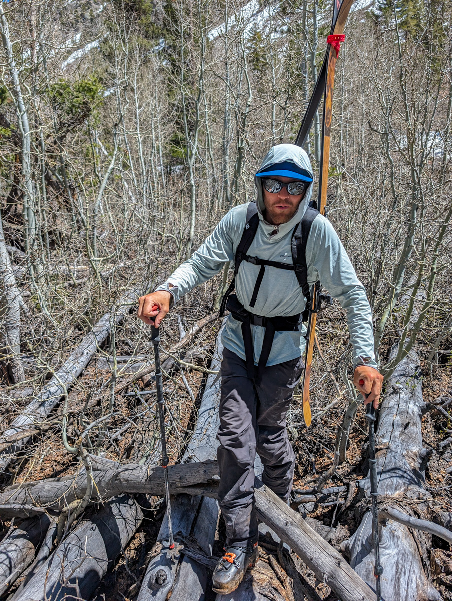
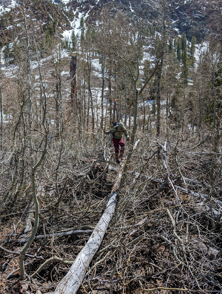
The first move is a 10 outta 10 bushwhack/creek crossing.
I’d found a pretty clean line through this zone when we were here on May 6 and it delivered.
We got through the madness in only 10 minutes.


It’s so bad in there you mostly have to walk on fallen trees to keep yourself up off the ground and the insanity below.
From there it was a bit of rock walking to get on snow.
Skins and Lee took the lead.


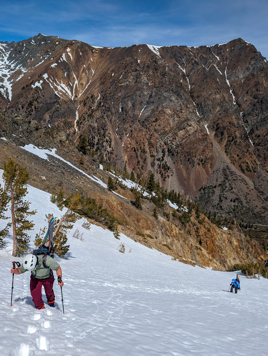
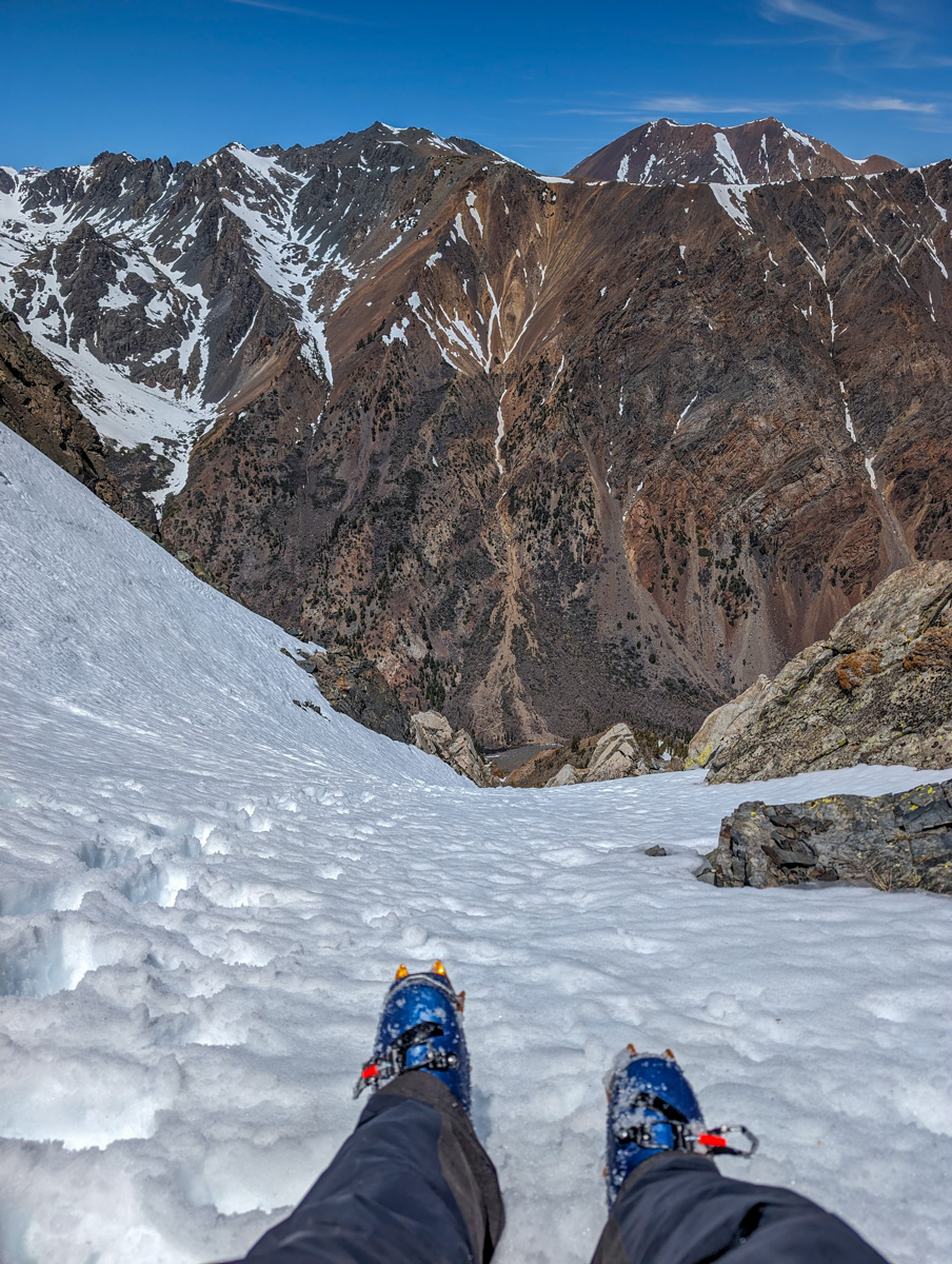
About halfway up the Dog Leg Chute, we switched to crampons.
The snow was already deep and sticky.
It hadn’t frozen the night before…
Or the night before that.
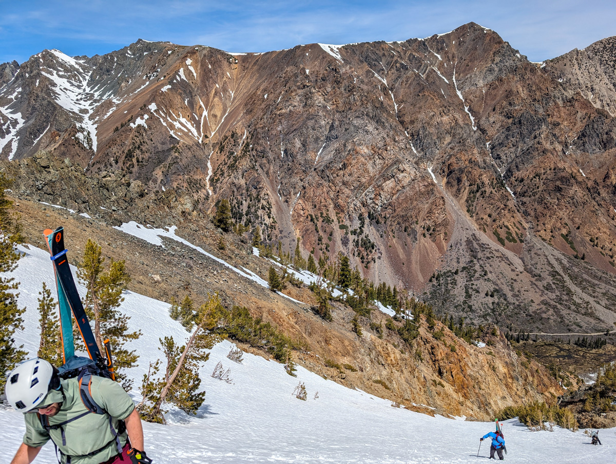
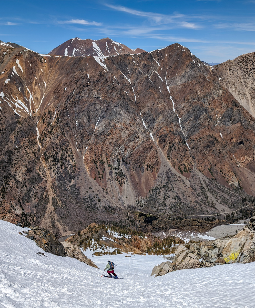
We slogged up in the deep slush and finally escaped the chute after a long grind.
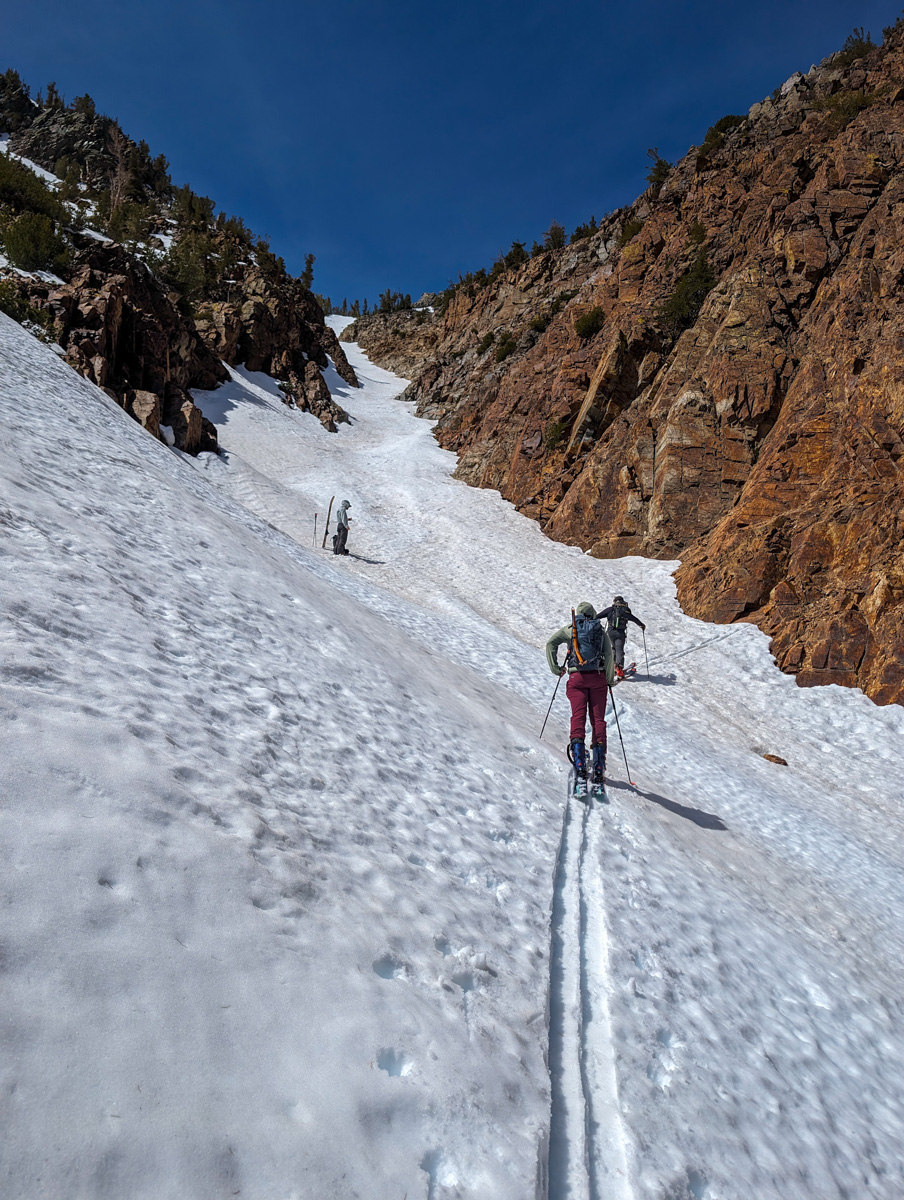
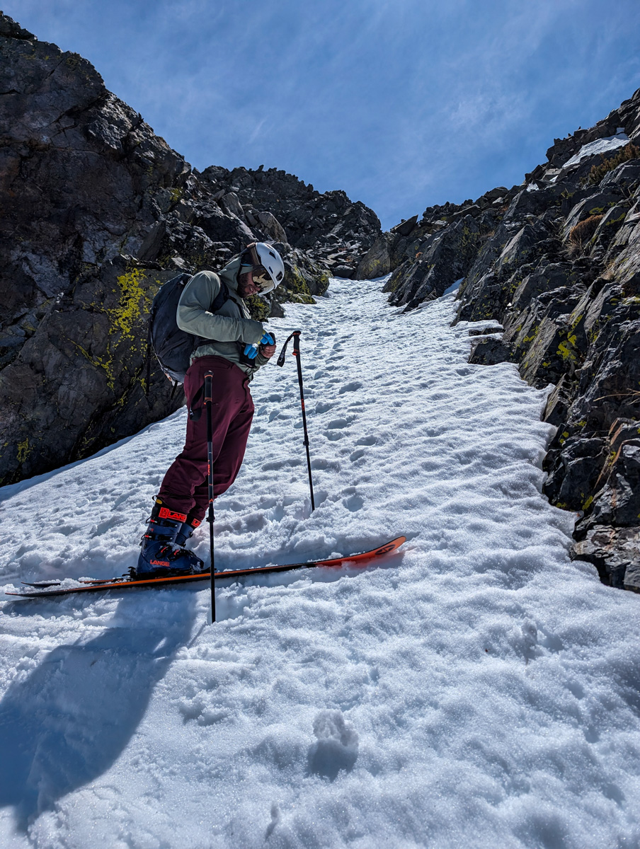
A hard left took us onto the upper apron that leads to the summit.
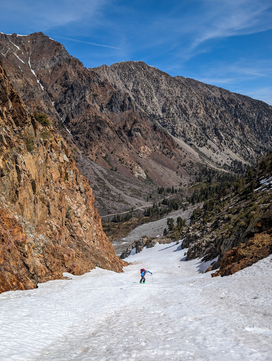

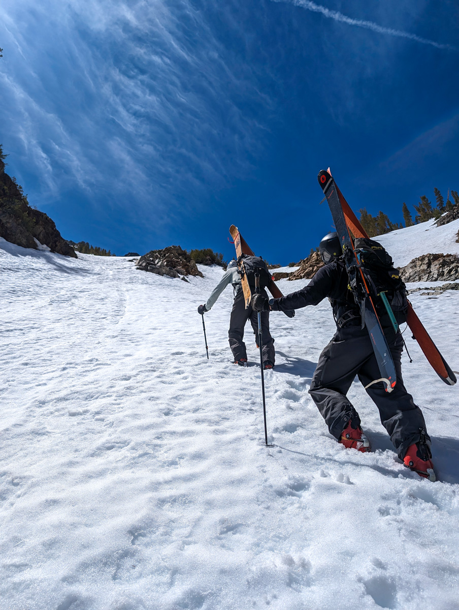
Fox took the lead for the first half of this.
The snow continued deep and manky.
Lee took over for the last pitch and we topped out after 2 hours and 55 minutes.


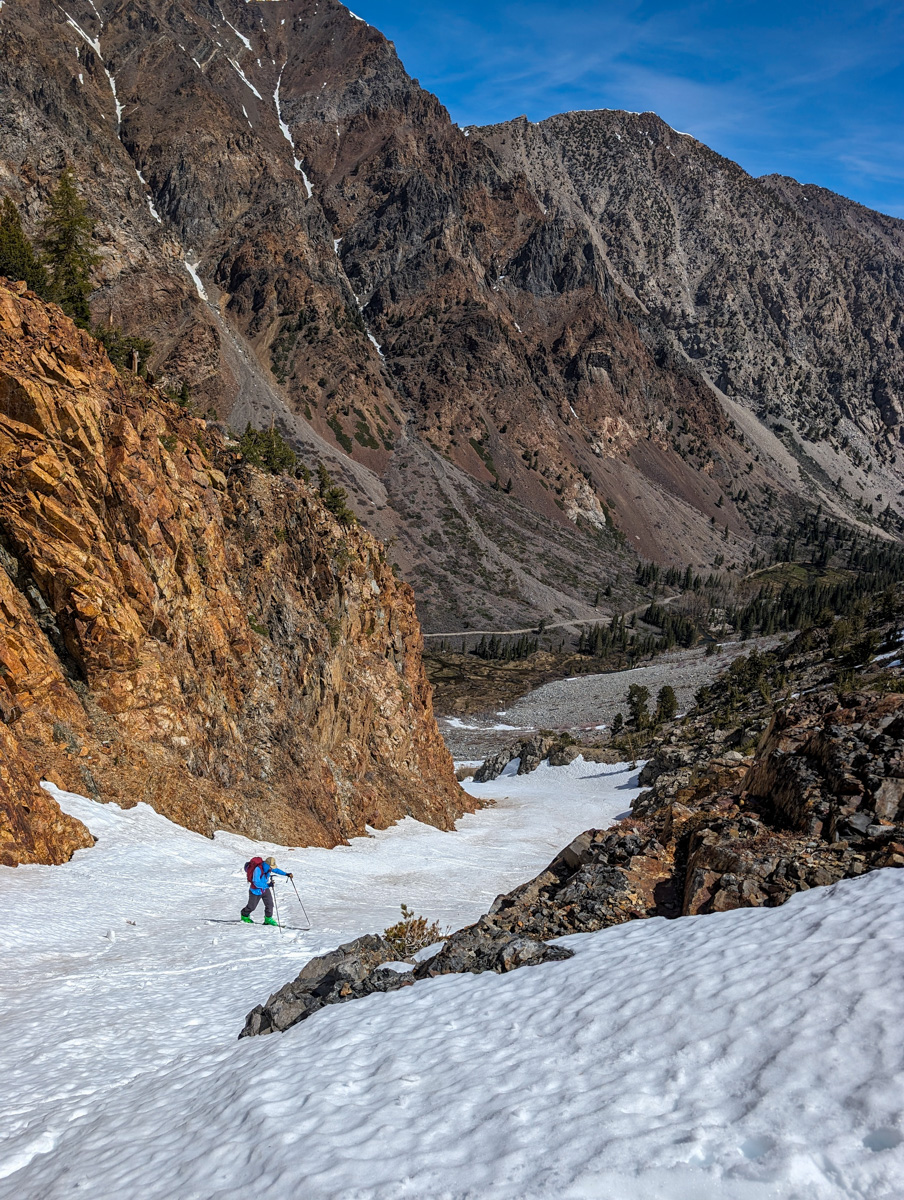
We took a healthy break and dropped in before things got any mankier.
The upper section skied well.
Proper corn.


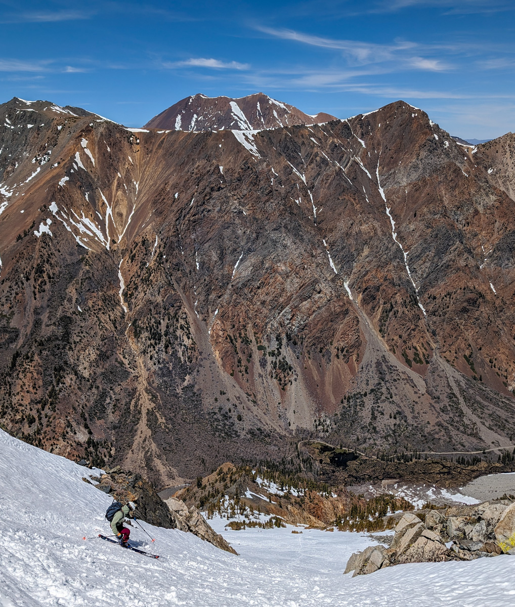
The lower part of the apron got a bit sticky.
Things improved entered the chute before the thing changed aspects to the east.
Once in the true northeast-facing part of the chute, it got so sticky.


The key was to be last and stay right in the other people’s tracks.
That’s what I did…
The final reward was a neat rock-lined chute at the very bottom that took us directly to the creek.

From there it was a bit of a bushwhack to get to the bushwhack that crosses the creek.
Back at the car after 4 hours and 28 minutes.
We zipped directly back to Mammoth hoping for “The Rolling Chef” burritos but the closed on us and we pivoted to “Latin Market” burritos that are always top notch.
Even when the snow is funky, the living is good here on the Eastside.
Thanks, California!


You might also like:


LAS VEGAS (FOX5) — Conservation groups are pushing back against a new state mapping tool that identifies federal lands potentially available for development in Nevada.
The governor’s office, in partnership with the Bureau of Land Management Nevada, unveiled the interactive map this week to make it easier to find federal land that may be available for development throughout the state and in the Las Vegas Valley.
“It is shocking to look at the map and see how many lands could potentially be sold off,” said Olivia Tanager, executive director of the Sierra Club Toiyabe Chapter.
Tanager said she was surprised at how many federal lands were identified for disposal when she first looked at the map.
“Places like Red Rock and Sloan Canyon in Southern Nevada are what draw people to live in Southern Nevada. We cannot continue to develop right up onto the boundaries or perhaps even in these precious places,” Tanager said.
The conservation group says the mapping tool is the latest effort to treat Nevada’s public lands as a real estate inventory rather than a shared public resource.
“We know that a lot of these areas are environmentally sensitive. We know that there are endangered species on these lands,” Tanager said.
MORE ON FOX5: Nevada unveils interactive tool mapping federal lands available for possible development, other uses
Housing concerns
Lawmakers have proposed using federal lands to create more affordable housing. Several areas at the edges of the Vegas Valley have been identified for potential development on the mapping tool. Tanager said she does not see that as a viable solution.
“The areas on the outskirts or far outside of existing urban areas are wholly inappropriate for affordable housing. Housing that is located that far away from services will never be truly affordable,” Tanager said. “As folks have to live further and further away from resources like schools and grocery stores, transportation costs go up substantially.”
The conservation group says the valley should fill in open lots and build upward within the existing urban core instead of building outward.
“We know that sprawl and developing on the outskirts of the valley worsens air quality as well from increased transportation,” Tanager said. “We know that sprawl is incredibly water-intensive. The further out you build, the harder it is to recapture that water.”
The Sierra Club Toiyabe Chapter says treating federal lands as disposable assets could set a dangerous precedent that accelerates privatization efforts and undermines the principle that public lands should remain in public hands for future generations.
Approximately 85% of Nevada’s total land area is owned by the federal government.
The state says the tool is designed to bolster information sharing about federal lands. The mapping tool is available here.
Copyright 2026 KVVU. All rights reserved.

LAS VEGAS (KSNV) — In the desert climate of Southern Nevada, WOW Carwash says it is working year-round to conserve water and reduce its environmental impact, using a combination of water-reclamation technology, biodegradable soaps and energy-efficient equipment.
The Las Vegas-born company says washing a car at home uses roughly 100 gallons of water. By comparison, WOW says it uses about 30 gallons per vehicle and reclaims up to 80% of the water.
WOW says its water-reclamation system exceeds typical local requirements. While local car washes are only required to have one sand and oil separator, WOW says it has four, along with a mud tank and UV filters designed to recycle water, reduce daily water use and ensure no solids are sent to the sewer system.
The company says all water from a WOW Carwash enters a 1,500-gallon mud tank underground at each location to begin separating soils from the water. From there, WOW says the water passes through a series of four sand and oil separators, where oils float to the surface, and soils sink to the bottom. WOW says the cleaned water is then pumped through UV and micron filters to remove remaining contaminants so it can be recycled and reused in the car wash.
WOW also says it repurposes the dirt washed off vehicles. The company says its water-reclamation tanks are pumped regularly by licensed vacuum trucks to maintain efficiency, and what is pumped out is then utilized as fertilizer.
WOW says all cleaning agents used in its tunnel wash process are environmentally safe and biodegradable, and that the soaps are safe to the human touch and for a vehicle’s paint while still being tough on dirt. The company says the cleaning agents break down naturally, reducing harmful runoff that could otherwise flow into storm drains and local waterways.
To reduce its carbon footprint, WOW says it uses energy-efficient equipment, including Variable Frequency Drives that allow electric motors to “ramp down” when demand is low to reduce electricity use during operations.

‘);
Las Vegas 2026
‘;
What will the new year bring to the valley? These are the biggest stories we’re watching. ‘;
2025: Las Vegas Year in Review
‘;
Look back at the biggest stories and events that took place in Las Vegas in 2025
‘;
Nevada’s ‘white gold’ rush
‘;
Read our six-part series about the Nevada communities that are bearing the brunt of the country’s clean energy future.
‘;
JUDGING THE JUDGES 2025
‘; ‘;
WHAT ARE THEY HIDING?
‘;
Exposing officials and agencies keeping public records from the public. ‘;
CLICK HERE TO READ MORE
‘;
2023 YEAR IN REVIEW
‘;
CLICK HERE FOR MORE
‘;
REMEMBERING 9/11: 20 YEARS LATER
‘;
Looking back at the 2001 terror attacks and how they affected Las Vegas and the world.
‘;
Read more
‘;
MEET THE UNFORGETTABLE CLASS
‘;
‘; 2021
‘; ‘; ‘;
Harry Reid (1939-2021)
‘; ‘;
‘;
Senate leader and Nevada political titan ‘; Read more
‘; ‘;
HENRY RUGGS
DEADLY CRASH
‘; ‘;
‘;
CLICK FOR MORE
‘; ‘;
Sheldon Adelson (1933-2021)
‘; ‘;
‘;
Las Vegas visionary and Philanthropist. ‘; Read more
‘; ‘;
Tony Hsieh
(1973-2020)
‘; ‘;
‘;
Ex-Zappos and Downtown Project CEO left a lasting impression on Las Vegas.
‘; Read more
‘; ‘;
VEGAS REAWAKENING
‘;
A year after the pandemic began, the first weekend of spring showed a perfect storm of promise for Las Vegas’ recovery and brought optimism that visitors would indeed return to the city
‘;
Read more ‘;
Sign up for our free RJ politics email alerts.
‘};
Sign up for our free RJ Politics newsletter.
‘};
Sign up for our free newsletter below.’};
pScript.src = “https://embed.sendtonews.com/player3/embedcode.php?fk=” + fkId;
} else {
pHtml = $(“”);
pScript.src = “https://embed.sendtonews.com/player3/embedcode.js?fk=” + fkId + ‘&cid=5945&offsetx=0&offsety=0&floatwidth=400&floatposition=bottom-right’;
pScript.setAttribute(‘data-type’, ‘s2nScript’); //pScript[‘data-type’] = ‘s2nScript’;
}
elem.append(pHtml);
elem.append(pScript);
},
insertVideoExco: function(player_id) {
var elem = $(‘#stn-in-article-player’);
elem.addClass(‘rj-fuel-77’);
var pHtml = $(”,{‘class’:’embed-responsive embed-responsive-16by9′});
pHtml.append($(”,{‘class’:’embed-responsive-item’,’id’:player_id}));
var click_url=”/7at7/?utm_campaign=7at7&utm_medium=insert_widget&utm_source=article_page”;
var f_title = $(”,{‘class’:’f-title’}).append(
$(‘‘,{‘href’:click_url, ‘alt’:’7at7′}).append(
$(‘‘,{‘html’:’Watch 7@7 — now streaming’})
)
);
//var f_desc = $(”,{‘class’:’f-desc’,’html’:’exco ArticleStreaming id: c1be8808-a095-4573-8738-5987c99028cc’})
elem.append(pHtml);
elem.append(f_title);
//elem.append(f_desc);
var fjs = document.getElementsByTagName(‘script’)[0];
var js = document.createElement(‘script’);
js.className=”exco-player”;
js.src=”https://player.ex.co/player/”+player_id;
js.setAttribute(‘programmatic’, ‘true’);
fjs.parentNode.insertBefore(js, fjs);
var exco_tmr_count_story = 500;
var exco_tmr_check_story = setInterval(function () {
exco_tmr_count_story–;
console.log(‘rj_exco_t_story:’+exco_tmr_count_story+’_exco_player:’+typeof(ExCoPlayer));
if ( ‘undefined’ !== typeof(ExCoPlayer) ) {
console.log(‘rj_exco_connect:’+typeof(ExCoPlayer.connect(player_id)));
if ( ‘undefined’ !== typeof( ExCoPlayer.connect(player_id) ) ) {
clearInterval(exco_tmr_check_story);
var exco_api_story = ExCoPlayer.connect(player_id);
exco_api_story.init({
‘playbackMode’: ‘play-in-view’, //auto-play, click-to-play, play-in-view
‘mute’: true,
//’autoPlay’: true,
});
exco_api_story.on(‘player-ready’, function(data) {
console.log(‘rj_exco_story_on_player_ready’, data);
exco_api_story.play();
});
exco_api_story.on(‘player-load’, function(data) {
console.log(‘rj_exco_story_on_player_load’, data);
exco_api_story.play();
});
exco_api_story.on(‘player-playing’, function(data) {
console.log(‘rj_exco_story_on_play’, data); //does not fire on first auto play have to call .play()
});
exco_api_story.on(‘content-start’, function(data) {
console.log(‘rj_exco_story_on_content_start’, data);
if (dataLayer) {
dataLayer.push({
‘event’: ‘rjvideo’,
‘gtm.videoProvider’: ‘exco’,
‘gtm.videoTitle’: data.title,
‘gtm.videoUrl’: data.src,
‘gtm.videoDuration’: data.duration,
‘gtm.videoStatus’: ‘progress’, //start, progress, complete
‘gtm.videoPercent’: 1,
‘videoPlayerId’: data.playerId,
‘videoId’: data.id,
});
}
});
exco_api_story.on(‘content-progress’, function(data) {
console.log(‘rj_exco_story_on_content_progress’, data);
if (dataLayer) {
dataLayer.push({
‘event’: ‘rjvideo’,
‘gtm.videoProvider’: ‘exco’,
‘gtm.videoTitle’: data.title,
‘gtm.videoUrl’: data.src,
‘gtm.videoDuration’: data.duration,
‘gtm.videoStatus’: ‘progress’,
‘gtm.videoPercent’: data.progress,
‘videoPlayerId’: data.playerId,
‘videoId’: data.id,
});
}
});
exco_api_story.on(‘content-end’, function(data) {
console.log(‘rj_exco_story_on_content_end’, data);
if (dataLayer) {
dataLayer.push({
‘event’: ‘rjvideo’,
‘gtm.videoProvider’: ‘exco’,
‘gtm.videoTitle’: data.title,
‘gtm.videoUrl’: data.src,
‘gtm.videoDuration’: data.duration,
‘gtm.videoStatus’: ‘progress’,
‘gtm.videoPercent’: 100,
‘videoPlayerId’: data.playerId,
‘videoId’: data.id,
});
}
});
}
}
if (exco_tmr_count_story == 0) {
clearInterval(exco_tmr_check_story);
}
}, 100);
},
insertVideoFuel: function(channelId) {
/*
var _setting;
var u, param;
param = ‘file_path=Fuel Front Image Url.xlsx’;
//param += ‘&site_id=WebDevPublic’;
//param += ‘&sheet_name=api_do_not_change’;
param += ‘&range=all’;
param += ‘&method=read’;
u = ‘/wp-json/rj/v2/api?name=microsoft&end_point=/excel_data¶m=’+encodeURIComponent(param);
$.ajax({
type: ‘GET’,
url: u,
cache: true,
dataType: ‘json’,
success: function (response) {
if ( response.status == 1 && response.response && response.response.data ) {
_setting = response.response.data;
}
},
error: function (xhr, ajaxOptions, thrownError) {
console.log(‘rj_xhr.status:’ + xhr.status + ‘_error:’ + thrownError);
}
});
*/
var img_url=”https://res.cloudinary.com/review-journal/image/upload/f_auto,q_auto,c_scale,w_1200/v1611081380/webdev/New7at7onGray.jpg”; //response.feed.entry[0][‘gsx$imageurl’][‘$t’];
//var description = _setting[1][3];//response.feed.entry[0][‘gsx$description’][‘$t’];
var elem = $(‘#stn-in-article-player’);
//if we do not add this info google will detect this fuel video without proper data need to fix in search console
elem.attr({
‘itemscope’: ”,
‘itemprop’: ‘VideoObject’,
‘itemtype’: ‘https://schema.org/VideoObject’,
})
.append($(‘‘,{‘itemprop’:’description’,’content’:’7 minutes of local non-stop news, free for all users.’}))
.append($(‘‘,{‘itemprop’:’name’,’content’:’7@7 Articles Channel’}))
.append($(‘‘,{‘itemprop’:’thumbnailUrl’,’content’:img_url}))
.append($(‘‘,{‘itemprop’:’uploadDate’,’content’:’2021-01-18T00:00:00+00:00′}))
.append($(‘‘,{‘itemprop’:’contentUrl’,’content’:’https://fuel-streaming-prod01.fuelmedia.io/v1/sem/’+channelId+’.m3u8′}));
//’https://fuel-streaming-prod01.fuelmedia.io/player/1.0/player.min.js’; //https://fuel-streaming-prod01.fuelmedia.io/player/v3/fuel.js
var pScript = document.createElement(“script”);
pScript.type=”text/javascript”;
pScript.src=”https://fuel-streaming-prod01.fuelmedia.io/player/v3/fuel.js”;
//pScript.async = true;
pScript.setAttribute(‘id’, ‘fuel-player-script’);
elem.append(pScript);
elem.addClass(‘rj-fuel-77’);
var fuel_float=”true”;
if (localStorage.getItem(‘rjIsSubscribed’) === ‘1’ || document.body.classList.contains(‘logged-in’)) {
console.log(‘fuel_disabled_float’);
fuel_float=”false”;
; }
var pHtml = $(‘
var click_url=”/7at7/?utm_campaign=7at7&utm_medium=insert_widget&utm_source=article_page”;
var f_title = $(”,{‘class’:’f-title’}).append(
$(‘‘,{‘href’:click_url, ‘alt’:’7at7′}).append(
$(‘‘,{‘html’:’Watch 7@7 — now streaming’})
)
);
//var f_desc = $(”,{‘class’:’f-desc’,’html’:description})
elem.append(pHtml);
elem.append(f_title);
//elem.append(f_desc);
//var is_android = /(android)/i.test(navigator.userAgent);
if (true) {
var tmr = setInterval(function() {
document.getElementsByTagName(‘fuel-video’)[0].player.play();
clearInterval(tmr);
},1000);
}
},
videoIDs: {
//’category-local’: {‘id’: ‘c1be8808-a095-4573-8738-5987c99028cc’, ‘provider’:’exco’},
//’category-business’: {‘id’: ‘c1be8808-a095-4573-8738-5987c99028cc’, ‘provider’:’exco’},
‘category-local’: {‘id’: ‘81814da7-67fe-4e54-be92-55046afbb3bb’, ‘provider’:’fuel’},
‘category-business’: {‘id’: ‘81814da7-67fe-4e54-be92-55046afbb3bb’, ‘provider’:’fuel’},
‘category-formula-1’ : {‘id’: ‘fds27xag’},
‘tag-coronavirus’: {‘id’: ‘u37v495p’, ‘app_id’: ‘QpkVQUhA’},
‘category-politics-and-government’: {‘id’: ‘kqRvD0a8’},
‘tag-mc-opinion’: {‘id’: ‘ohls3BOc’}, //’kqRvD0a8′; 2023-03-21_14:30
‘tag-mc-crime’: {‘id’: ‘kqRvD0a8’},
‘tag-2020-election’: {‘id’: ‘kqRvD0a8’},
‘rj-main-category–science-and-technology’: {‘id’: ‘j88hQyle’, ‘app_id’: ‘kVqKLwXg’},
‘tag-mc-news’: {‘id’: ‘pCyFtg5f’, ‘app_id’: ‘QpkVQUhA’},
‘rj-main-category–raiders’: {‘id’: ‘bpswZwKM’, ‘app_id’: ‘k07ZZ08J’},
‘tag-mc-sports’: {‘id’: ‘dbx2WkwF’, ‘app_id’: ‘k1Vj5iYY’},
‘rj-main-category–food’: {‘id’: ‘3DQjoZb7’, ‘app_id’: ’40kxsoyw’},
‘tag-mc-entertainment’: {‘id’: ‘YBuF2XdP’, ‘app_id’: ‘7oJQh6dl’},
‘tag-mc-live-well’: {‘id’: ‘KED23a4w’}, //’31shkzyP’; 2023-03-21_14:30
‘tag-mc-life’: {‘id’: ‘aaWqdJ5u’, ‘app_id’: ‘m5zMjg65’},
‘tag-mc-autos’: {‘id’: ‘kag2nBSV’, ‘app_id’: ‘4bdELTqB’},
‘tag-mc-homes’: {‘id’: ‘R0zQNouh’, ‘app_id’: ‘nvYRBPOO’}, // ‘tag-mc-homes’: {‘id’: ‘HPa6ehMQ’}
‘rj-story-full’: {‘id’: ‘81814da7-67fe-4e54-be92-55046afbb3bb’, ‘provider’:’fuel’}
},
getVideoId: function() {
//var fkId = false,
var vdo_k = false;
for (var checkClass in stnInArticleVideo.videoIDs) {
if (stnInArticleVideo.wrapper.hasClass(checkClass)) {
//fkId = videoIDs[checkClass].id;
vdo_k = checkClass;
break;
}
}
return vdo_k; //fkId;
},
run: function() {
var vdo_id;
stnInArticleVideo.wrapper = $(‘article.rj-story.rj-story-full’);
if (stnInArticleVideo.wrapper && stnInArticleVideo.canInsertVideo()) {
var vdo_k = stnInArticleVideo.getVideoId();
if (vdo_k) {
if (stnInArticleVideo.videoIDs[vdo_k].hasOwnProperty(‘provider’)) {
switch(stnInArticleVideo.videoIDs[vdo_k].provider) {
case ‘fuel’:
stnInArticleVideo.insertVideoFuel(stnInArticleVideo.videoIDs[vdo_k].id);
break;
case ‘exco’:
stnInArticleVideo.insertVideoExco(stnInArticleVideo.videoIDs[vdo_k].id);
break;
}
} else {
vdo_id = stnInArticleVideo.videoIDs[vdo_k].id;
var userAgent = navigator.userAgent;
if ( (userAgent.indexOf(‘RJApp’) > -1) && (stnInArticleVideo.videoIDs[vdo_k].app_id) ) {
vdo_id = stnInArticleVideo.videoIDs[vdo_k].app_id;
}
stnInArticleVideo.insertVideo(vdo_id);
}
}
}
}
};
stnInArticleVideo.run();
});
//}
‘;
html += ”;
html += ”;
$(‘.nlsm-small’).addClass(‘livewell’).html(html);
return;
}
if ($(‘.rj-story-sponsored-full’).length>0) {
return;
}
if ($(‘.rj-story-full’).hasClass(‘tag-2026-yearahead’)) {
html=””;
html += ‘‘;
html += ‘
html += ‘
html += ”;
$(‘.nlsm-small’).addClass(‘yea4-2025-embed’).html(html);
return;
}
if ($(‘.rj-story-full’).hasClass(‘tag-2025-year-in-review’)) {
html=””;
html += ”;
html += ‘
html += ‘
html += ”;
$(‘.nlsm-small’).addClass(‘yea4-2025-embed’).html(html);
return;
}
if ($(‘.rj-story-full’).hasClass(‘tag-thacker-pass’)) {
html=””;
html += ”;
html += ‘
html += ‘
html += ”;
$(‘.nlsm-small’).addClass(‘thacker-pass-embed’).html(html);
return;
}
if ($(‘.rj-story-full’).hasClass(‘tag-judging-the-judges-2025’)) {
html=””;
html += ‘
html += ‘
html += ”;
html += ”;
html += ‘
$(‘.nlsm-small’).addClass(‘black-book-embed’).html(html);
return;
}
if ($(‘.rj-story-full’).hasClass(‘tag-black-book’)) {
html=””;
html += ”;
html += ‘ ‘;
‘;
html += ”;
$(‘.nlsm-small’).addClass(‘black-book-embed’).html(html);
return;
}
if ($(‘.rj-story-full’).hasClass(‘tag-telles-murder-trial’)) {
html=””;
html += ”;
html += ”;
html += ‘Robert Telles On Trial: Full Coverage‘;
html += ”;
html += ”;
$(‘.nlsm-small’).addClass(‘telles_murder’).html(html);
return;
}
if ($(‘.rj-story-full’).hasClass(‘tag-jeff-german-murder’) || $(‘.rj-story-full’).hasClass(‘tag-remembering-jeff-german’)) {
html=””;
html += ”;
html += ”;
html += ‘‘;
html += ”;
html += ”;
$(‘.nlsm-small’).addClass(‘jeff_german’).html(html);
return;
}
if ($(‘.rj-story-full’).hasClass(‘tag-what-are-they-hiding’)) {
html=””;
html += ”;
html += ”;
html += ‘
html += ‘
html += ‘
html += ”;
html += ”;
$(‘.nlsm-small’).addClass(‘2023-year-in-review’).html(html);
return;
}
if ($(‘.rj-story-full’).hasClass(‘tag-2023-year-in-review’)) {
html=””;
html += ”;
html += ”;
html += ‘
html += ‘
html += ”;
html += ”;
$(‘.nlsm-small’).addClass(‘2023-year-in-review’).html(html);
return;
}
if ($(‘.rj-story-full’).hasClass(‘tag-msg-sphere’)) {
html=””;
html += ”;
html += ”;
html += ‘‘;
html += ”;
html += ”;
$(‘.nlsm-small’).addClass(‘tag-msg-sphere’).html(html);
return;
}
if ($(‘.rj-story-full’).hasClass(‘tag-911-anniversary’)) {
html=””;
html += ”;
html += ”;
html += ‘
html += ‘
html += ‘
html += ”;
html += ”;
$(‘.nlsm-small’).addClass(‘anniversary-911’).html(html);
return;
}
if ($(‘.rj-story-full’).hasClass(‘tag-class-of-2021’)) {
html=””;
html += ”;
html += ”;
html += ‘
html += ‘
html += ‘
html += ‘‘;
html += ‘
html += ‘
html += ‘
html += ‘‘;
html += ‘
html += ‘
html += ”;
html += ”;
$(‘.nlsm-small’).addClass(‘class-2021’).html(html);
return;
}
if ($(‘.rj-story-full’).hasClass(‘tag-2022-election’)) {
html=””;
html += ”;
html += ”;
html += ”;
$(‘.nlsm-small’).addClass(‘election-2022’).html(html);
return;
}
if ($(‘.rj-story-full’).hasClass(‘tag-harry-reid-1939-2021’)) {
html=””;
html += ”;
html += ”;
html += ‘
html += ‘
html += ‘
html += ‘
html += ‘‘;
html += ‘
html += ‘
html += ‘
html += ‘
html += ‘
html += ”;
html += ”;
$(‘.nlsm-small’).addClass(‘harry-reid’).html(html);
return;
}
if ($(‘.rj-story-full’).hasClass(‘tag-henry-ruggs’)) {
html=””;
html += ”;
html += ”;
html += ‘
html += ‘
html += ‘
html += ‘
html += ‘‘;
html += ‘
html += ‘
html += ‘
html += ‘
html += ”;
html += ”;
$(‘.nlsm-small’).addClass(‘henry-ruggs’).html(html);
return;
}
if ($(‘.rj-story-full’).hasClass(‘category-homicides’)) {
html=””;
html += ”;
html += ”;
html += ”;
$(‘.nlsm-small’).addClass(‘homicides’).html(html);
return;
}
if ($(‘.rj-story-full’).hasClass(‘tag-sheldon-adelson’)) {
html=””;
html += ”;
html += ”;
html += ‘
html += ‘
html += ‘
html += ‘
html += ‘‘;
html += ‘
html += ‘
html += ‘
html += ‘
html += ‘
html += ”;
html += ”;
$(‘.nlsm-small’).addClass(‘sheldon-adelson’).html(html);
return;
}
if ($(‘.rj-story-full’).hasClass(‘tag-tony-hsieh’)) {
html=””;
html += ”;
html += ”;
html += ‘
html += ‘
html += ‘
html += ‘
html += ‘‘;
html += ‘
html += ‘
html += ‘
html += ‘
html += ‘
html += ”;
html += ”;
$(‘.nlsm-small’).addClass(‘tony-hsieh’).html(html);
return;
}
if ($(‘.rj-story-full’).hasClass(‘tag-vegas-weekend’)) { //vegas-reawakening
html=””;
html += ”;
html += ”;
html += ‘
html += ‘
html += ‘
html += ”;
html += ”;
$(‘.nlsm-small’).addClass(‘vegas-reawakening’).html(html);
return;
}
//add newsletters embed
var default_category_to_show = [‘News’, ‘Local’, ‘Life’, ‘Crime’];
var newsletter_1st_lv = [];
newsletter_1st_lv[‘default’] = {‘id’:’starting_point,pm_update’, ‘track_name’:’StartingPoint’, ‘title’:’LOCAL NEWS YOUR WAY‘, ‘subtitle’:’Sign up for our free daily Morning and Afternoon Update newsletters.’};
newsletter_1st_lv[‘Sports’] = {‘id’:’sports’, ‘track_name’:’Sports’, ‘title’:’SPORTS NEWS YOUR WAY‘, ‘subtitle’:’Sign up for our free Sports Update newsletter.’};
newsletter_1st_lv[‘Business’] = {‘id’:’business’, ‘track_name’:’Business’, ‘title’:’BUSINESS NEWS YOUR WAY‘, ‘subtitle’:’Sign up for our free Business Update newsletter.’};
newsletter_1st_lv[‘Live Well’] = {‘id’:’livewell’, ‘track_name’:’livewell’, ‘title’:’LIVE WELL NEWSLETTER‘, ‘subtitle’:’Your weekly source for living your healthiest and happiest life.’};
newsletter_1st_lv[‘Entertainment’] = {‘id’:”,’alert_id’:’entertainment’, ‘track_name’:’Entertainment’, ‘title’:’WANT THE LATEST ON LAS VEGAS ENTERTAINMENT?‘, ‘subtitle’:’Sign up for free entertainment email alerts’};
//newsletter_1st_lv[‘Nevada Preps’] = {‘id’:’nevada_preps’, ‘title’:’HIGH SCHOOL SPORTS YOUR WAY‘, ‘subtitle’:’Stay up to date with our free Nevada Preps newsletter.’};
//newsletter_1st_lv[‘Investigations’] = {‘id’:’rj_investigates’, ‘title’:’INVESTIGATIVE NEWS YOUR WAY‘, ‘subtitle’:’Sign up for our free RJ Investigates newsletter.’};
var cat_has_subcat = [‘News’,’Business’,’Entertainment’,’Sports’, ‘Opinion’];
var newsletter_2nd_lv = [];
newsletter_2nd_lv[‘Politics and Government’] = {‘id’:”,’alert_id’:’political’, ‘track_name’:’Political’, ‘title’:’LOCAL, REGIONAL AND NATIONAL POLITICS COVERAGE‘, ‘subtitle’:’
//newsletter_2nd_lv[‘Politics and Government’] = {‘id’:’political’, ‘title’:’ELECTION 2020: BE INFORMED’, ‘subtitle’:’
//newsletter_2nd_lv[‘Debra J. Saunders’] = {‘id’:’44’, ‘title’:’YOUR WEEKLY POLITICAL FIX‘, ‘subtitle’:’Sign up for our free DC-LV newsletter with political stories from the swamp to the Strip.’};
//newsletter_2nd_lv[‘CES 2021’] = {‘id’:’ces’, ‘title’:’CES 2021: STAY IN THE KNOW’, ‘subtitle’:’
//newsletter_2nd_lv[‘TV’] = {‘id’:’tv_briefing’, ‘title’:’GET YOUR TV LISTINGS‘, ‘subtitle’:’Your Weekly TV Briefing.’};
//newsletter_2nd_lv[‘UNLV’] = {‘id’:’unlv_rebel_news’, ‘title’:’UNLV SPORTS YOUR WAY‘, ‘subtitle’:’Stay up to date on the Rebels with our free newsletter.’};
newsletter_2nd_lv[‘Rodeo’] = {‘id’:’rodeo_nfr’, ‘track_name’:’RodeoNFR’, ‘title’:’RODEO NEWS YOUR WAY‘, ‘subtitle’:’Don’t miss any of the action! Click here for full NFR coverage or Sign up for our free newsletter below’};
newsletter_2nd_lv[‘Raiders News’] = {‘id’:’vegasnation’, ‘track_name’:’VegasNation’, ‘title’:’WANT EVEN MORE RAIDERS NEWS?‘, ‘subtitle’:’Sign up for our free Vegas Nation newsletter.’};
newsletter_2nd_lv[‘Golden Knights’] = {‘id’:”,’alert_id’:’golden_knights’, ‘track_name’:’GoldenKnights’, ‘title’:’WANT MORE KNIGHTS IN YOUR DAY?‘, ‘subtitle’:’Sign up for free Golden Knights email alerts for all the latest updates’};
var main_cat=””;
var m_hierarchy = [];
var m_cat = [];
var m_hl_cat=””;
if (window.dataLayer[0].metrics) {
main_cat = window.dataLayer[0].metrics.section; //National Finals Rodeo
m_hierarchy = window.dataLayer[0].metrics.hierarchy.split(‘ | ‘); //”Sports | Rodeo | National Finals Rodeo”
m_cat = window.dataLayer[0].metrics.categories; //[“National Finals Rodeo”,”Rodeo”,”Sports”]
m_hl_cat = window.dataLayer[0].metrics[‘hl-category’]; //Sports
}
var i, k, found, newsletter;
newsletter = false;
found = false;
if (default_category_to_show.includes(m_hl_cat)) {
newsletter = newsletter_1st_lv[‘default’];
}
if (newsletter_1st_lv.hasOwnProperty(m_hl_cat)) {
newsletter = newsletter_1st_lv[m_hl_cat];
}
// check main category
if (newsletter_2nd_lv.hasOwnProperty(main_cat)) {
found = true;
newsletter = newsletter_2nd_lv[main_cat];
}
if (!found) {
// check in hierarchy (main category hierarchy)
i = m_hierarchy.length;
while (!found && i >= 0) {
i–;
if (i > 0) {
if (newsletter_2nd_lv.hasOwnProperty(m_hierarchy[i])) {
found = true;
newsletter = newsletter_2nd_lv[m_hierarchy[i]];
}
} else {
// i=0, check first level
if (newsletter_1st_lv.hasOwnProperty(m_hierarchy[i])) {
found = true;
newsletter = newsletter_1st_lv[m_hierarchy[i]];
}
}
}
}
if (!found) {
// check in category
i = m_cat.length;
while (!found && i > 0 && cat_has_subcat.includes(m_hl_cat)) {
i–;
if (newsletter_2nd_lv.hasOwnProperty(m_cat[i])) {
found = true;
newsletter = newsletter_2nd_lv[m_cat[i]];
}
}
}
if (newsletter !== false && !$(‘.rj-story-full’).hasClass(‘tag-hide-newsletter’) && !$(‘.rj-story-full’).hasClass(‘ rj-story-sponsored-full’)) {
var alert_id = ”;
if (newsletter.alert_id) {
alert_id = newsletter.alert_id;
}
html=””;
html += ”;
html += ”;
html += ”;
$(‘.nlsm-small’).html(html);
}
//});
})(jQuery);
-

 Minnesota3 minutes ago
Minnesota contributes two items to the America250 time capsule
-

 Mississippi6 minutes ago
Kohen Wiley: Police shooting of a 1-year-old Mississippi boy ignites tension between police and Black residents | CNN
-

 Missouri11 minutes ago
What’s closed on Juneteenth in Missouri? Check trash, libraries, banks
-

 Montana18 minutes ago
Your guide to local sports events, plus what’s on TV for June 19
-

 Nebraska21 minutes ago
Nebraska’s governor doesn’t carry a state-issued phone. Critics call it an abuse of state disclosure laws. – Flatwater Free Press
-

 Nevada26 minutes ago
Conservation groups oppose potential sale of federal lands highlighted in land mapping tool
-

 New Hampshire33 minutes ago
Portsmouth Pride 2026 is a protest and a celebration
-

 New Jersey36 minutes ago
Historical marker recognizing Lawnside, New Jersey, to be unveiled Friday

