Alaska
‘Fat is fit’: Alaska’s Katmai National Park gears up for annual Fat Bear Week

It’s once again time to celebrate the fattest bears in all the land.
Fat Bear Week 2023, the ninth-annual edition of a “March madness-style” bracket competition that pits the fattest brown bears at Katmai National Park in Alaska against each other, is set to begin, Keith Moore, lead interpretive park ranger at Katmai National Park and Preserve, told ABC News.
The bears of the Brooks River have spent the summer fattening up on salmon, berries and grasses in preparation of their annual winter hibernation, according to the park.
Katmai National Park
STOCK PHOTO/Getty Images
In the bear kingdom, “fat is fit,” and the more gargantuan, the better, according to Moore.
The brown bears are now in prime shape to enter hibernation around November and eventually experience a one-third loss of their body weight through the winter season, when they start to emerge from their dens around May, Moore said.
How Fat Bear Week came into fruition
When the first Fat Bear competition began in 2014, it consisted of one single day when a few of the parks’ most notably sizable bears were placed in competition with each other, Moore said.

A brown bear walks to a sandbar to eat a salmon it had just caught at Brooks Falls in Katmai National Park and Preserve, Ala., July 4, 2013.
Mark Thiessen/AP, FILE
By the next year, the contest transformed into a “globally recognized” event that required more days and more contenders, Moore said. In 2022, more than a million ballots were cast for the competition.
“I wouldn’t be surprised if we get even more attention this year,” he said.
Why Fat Bear Week is important
With the popularity that Fat Bear Week brings, park officials are able to direct the extra attention to conservation efforts in the region.
The bears rely on the abundance of the sockeye salmon run within the Brooks River, a mile-and-a-half long stream that contains the largest concentration of brown bears on the planet, Moore said.

Two brown bears look for salmon at Brooks Falls at Katmai National Park and Preserve, Alaska, July 4, 2013.
Mark Thiessen/AP, FILE
The brown bears of Katmai National Park represent the overall health of the local ecosystem and Bristol Bay watershed, Moore said.
“It’s just an incredible opportunity for people to celebrate the success and survival of these bears,” he said.
Notable past winners of Fat Bear Week
Last year, a particularly large brown bear named “747” won the competition for the second time.
When 747 goes into hibernation, he is expected to weigh about 1,400 pounds, Moore said. The bears are often so “bulbous” that they appear cartoonish, Moore said, adding that their heads often appear much smaller than their bodies.

Brown bears or grizzly bears gather at Brooks Falls in Katmai National Park and Preserve, Ala.
STOCK PHOTO/Getty Images
Other past winners include 480 Otis, four-time champ and fan favorite, 435 Holly, the 2019 winner renowned for her maternal instincts and ability to “balloon up each fall ” and 409 Beadnose, another female bear who won in 2018 for her “most fabulous flab.”
Rangers are able to tell the bears apart based on physical markers, such as scars and birthmarks, Moore said.
The bears are named based on a numbering system within the bear monitoring program, he said. They are not tagged or collared.
How to compete in Fat Bear Week
Starting on Monday, participants can start filling out their brackets as head-to-head matchups are announced during a live chat on the Explore.org website.
From Thursday through Oct. 10, voters can cast their ballots at fatbearweek.org.
The winner will be crowned the 2023 Fat Bear Week champion on Oct. 10.

Alaska
Short-lived cold snap, with another warming trend this weekend

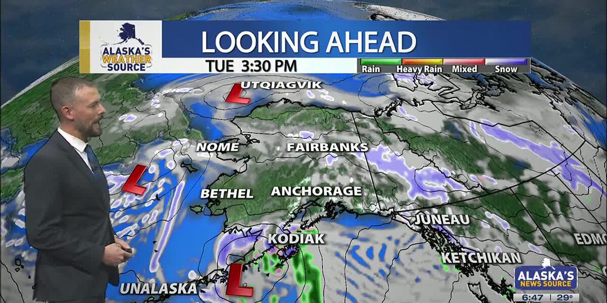
ANCHORAGE, Alaska (KTUU) – Temperatures across the state are cooling off, as our strong low from the weekend moves into the Chukchi Sea. This will set up for colder air to spread across the state this week, as another short-lived cold snap is expected. While some light snow is possible for the Interior, areas of the Slope and Western Alaska, Southcentral will stay on the drier side until the night. Meanwhile, Southeast will continue to hold onto moderate rain with gusty conditions.
SOUTHCENTRAL:
Temperatures this morning are 10 to 20 degrees colder than yesterday, as colder air has settled back into Southcentral. Clear skies and calm winds are evident this morning for parts of the region, with light snow falling through the Copper River Basin. We’ll see fairly quiet conditions today, outside of Kodiak which will see increasing snow and rain into the afternoon and evening hours. This comes as our next area of low pressure moves up the Alaska Peninsula.
We’ll see light snow spreading north across the Kenai overnight into Wednesday, with light snow expected through Prince William Sound. Several inches are likely through the Kenai and Chugach Mountains, with the pass expected to see a couple of inches of accumulation. Western parts of the Kenai will see the potential for a few inches, while inland areas of Southcentral largely stay dry. If Anchorage and surrounding locations see any accumulation, it’ll amount to less than half an inch.
As snow tapers off Wednesday, we’ll see the return to colder and drier conditions into Thursday. Thursday may be the coldest day this week across the region, before another warming trend carries us into next week. Right now holding with snow through early next week, but areas of wintry mix are possible as highs warm above freezing.
SOUTHEAST:
The winter storm warning for Skagway and higher elevations expired at 6am this morning. While some light snow showers are still possible, little accumulation will occur the rest of the day. Scattered to periodic showers are occurring elsewhere across Southeast today, with less than half an inch of rainfall through the day. Any moisture available into the evening will see a transition to some wintry mix or snow into Wednesday morning. However, the better chance will come from another low lifting north into the panhandle. Any snow and wintry mix we see for Wednesday will primarily stay confined to the central and southern panhandle. We’ll see much cooler weather taking hold this week for Southeast.
INTERIOR:
Some areas of light snow are possible this morning, with less than half an inch to be expected. While temperatures are still warm for much of the Interior, highs will steadily fall throughout the day. Many areas will see lows bottom out near or below zero by tomorrow morning. We’ll see high pressure keep things dry and sunny through the next couple of days, with the coldest stretch of weather from Wednesday morning into Thursday morning. Much like the rest of the state will experience, a warming trend arrives this weekend. We’ll see the return to highs in the 20s, with some snow in the forecast. Be prepared for some gusty conditions through the Alaska Range by the close of this week.
SLOPE/WESTERN ALASKA:
Areas of light snow and blowing winds will continue to impact the Slope, with a winter weather advisory remaining in place for the Central Brooks Range and the Beaufort Sea Coast. Both locations will see up to 1 inch of snow and gusty winds up to 35 mph. While the winter weather advisory will expire for the Central Brooks Range this afternoon, the Beaufort Sea Coast will see the alert continue into Tuesday evening. Snow and blowing snow will be the primary impact today, with a return to colder weather through the rest of this week, this comes as high pressure settles into the area.
The storm responsible for the damaging winds for Southcentral over the weekend, has pushed north into the Chukchi Sea. We’ll still see some light snow accumulations for Western Alaska, with 1 to 3 inches expected. Some fo the heaviest snow will fall across the Seward Peninsula and the Western Brooks Range.
An area of low pressure in the Bering Sea will keep gusty winds and snow in the forecast for Gambell/St. Lawrence. Be prepared for heavy snow at times and areas of reduced visibility. Overall, colder weather will settle into Western Alaska, with the possibility of morning fog in the valleys over the next few mornings.
ALEUTIANS:
Some light areas of snow will occur for the Pribilof Islands and into parts of the Alaska Peninsula today, as a weak low moves up the Peninsula. This will be the main focus for snow into Wednesday for Southcentral. This low will bring heavy precipitation and gusty winds for the Eastern Aleutians and the Alaska Peninsula. Looking ahead through the rest of the week, we can expect to see more a ridge beginning to build into the region. This ridge will slowly shift east, keeping several upper level disturbances traversing the Aleutians. Temperatures will remain fairly warm in the 30s and 40s.
OUTLOOK AHEAD:
Model consensus continues to agree on another warming trend heading our way into next week. This stretch of warmth will likely lead to many spots cementing themselves within the top warmest January’s on record. While we’ll spend the rest of this week on the colder side, highs steadily climb this weekend into next week. We’ll see highs in Southcentral climbing back above freezing, with areas of the Interior climbing back into the 20s.
Have a safe and wonderful Tuesday!
See a spelling or grammar error? Report it to web@ktuu.com
Copyright 2025 KTUU. All rights reserved.
Alaska
Anchorage, Alaska hit by hurricane-force winds, structures damaged across city

Associated Press
Hurricane-force winds cause widespread damage in Alaska’s largest city
Thousands of residents across Alaska’s largest city were still without power Monday, a day after a powerful storm brought hurricane-force winds that downed power lines, damaged trees, forced more than a dozen planes to divert, and caused a pedestrian bridge over a highway to partially collapse. A 132-mph (212-kph) wind gust was recorded at a mountain weather station south of Anchorage. A large low-pressure system in the Bering Sea brought the high winds, moisture and warmer than average temperatures — in the low 40s Fahrenheit (slightly over 4.4 degrees Celsius) — to Anchorage on Sunday, said National Weather Service meteorologist Tracen Knopp.
Alaska
Thousands without power in Alaska after hurricane-force winds hit

Thousands of residents in Anchorage, Alaska, faced widespread devastation and power outages Monday after hurricane-strength winds battered the city on Sunday.
Why It Matters
This latest incident comes as power outages across the United States have become a growing concern as extreme weather events increase in frequency and intensity, often leaving millions of Americans in precarious situations. Hurricanes, wildfires, ice storms and heatwaves have caused widespread disruptions, highlighting the vulnerability of aging electrical grids to severe conditions.
Prolonged outages not only hinder daily life by cutting off access to heating, cooling and essential appliances but also pose significant risks to public health, particularly for the elderly and those with medical conditions reliant on powered devices.
What To Know
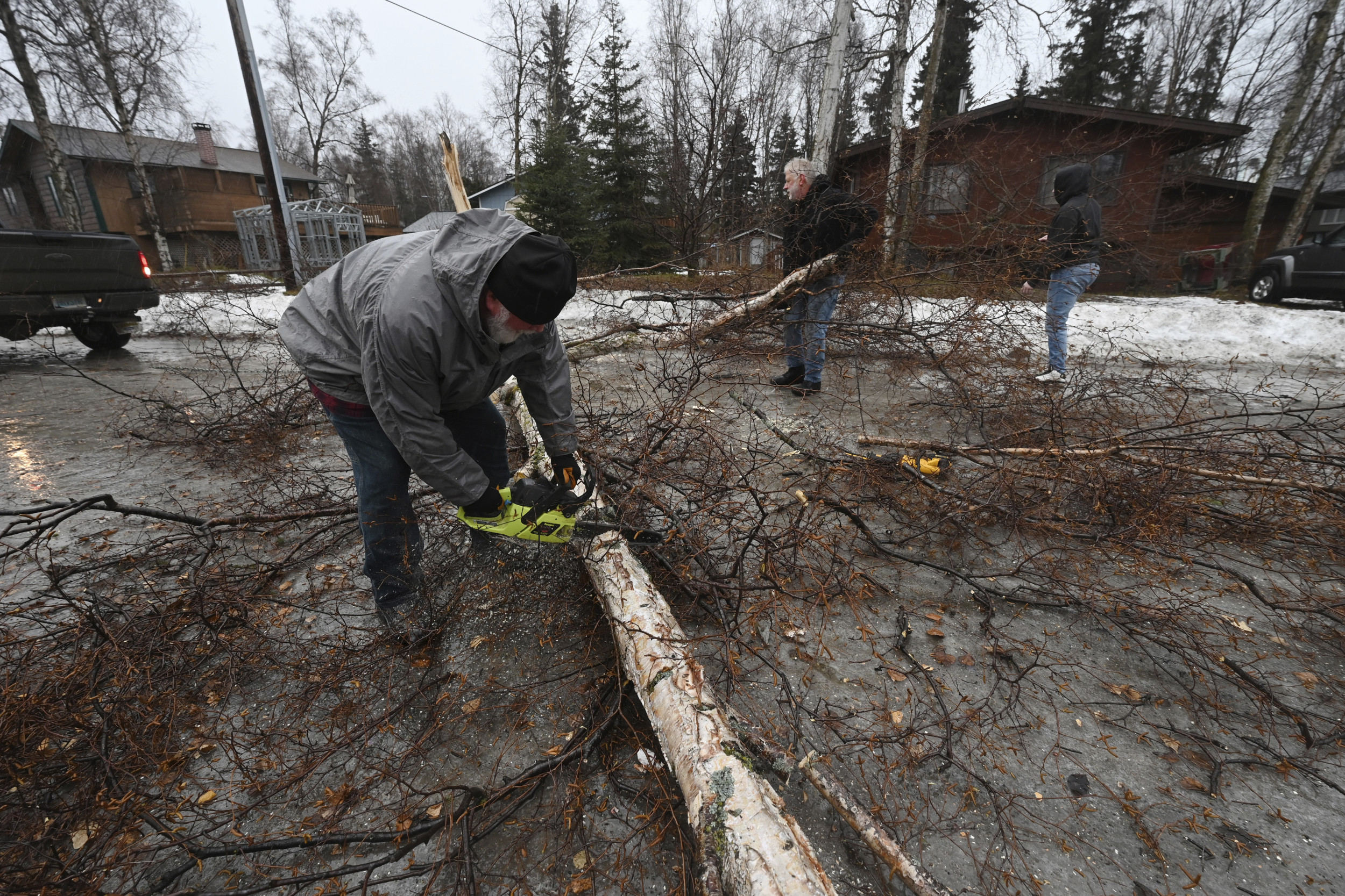
The Anchorage storm, which began Sunday, delivered gusts reaching 132 mph at a mountain weather station south of the city, according to the National Weather Service. Within Anchorage itself, winds hit 75 mph, toppling trees, scattering debris and partially collapsing a pedestrian bridge over the Seward Highway, the city’s main southern thoroughfare.
At the height of the storm, 17,500 customers were without power, according to Julie Hasquet, spokesperson for Chugach Electric Association. As of Monday, roughly 5,700 homes remained offline with full restoration expected to stretch into Tuesday.
Bill Roth/Anchorage Daily News/ AP
The storm’s chaos wasn’t limited to neighborhoods. Anchorage’s airport, a vital hub for passenger and cargo traffic, saw significant disruptions. Winds forced 13 aircraft, including a U.S. Air Force plane, to divert to Fairbanks, which sits nearly 360 miles away.
On the ground, emergency crews scrambled to clear bridge debris, which had obstructed traffic on the highway. However, no injuries were reported when the side fencing and roof of the bridge fell onto the four-lane divided highway on Sunday. Traffic was rerouted and crews removed the debris.
Alaska Department of Transportation spokesperson Shannon McCarthy pointed to the winds as the probable cause of the bridge failure. However, structural engineers are investigating to determine the full extent of the damage.
Meanwhile, the storm marked a rare convergence of high winds, warmer-than-average temperatures and moisture from a low-pressure system in the Bering Sea, said National Weather Service meteorologist Tracen Knopp. Anchorage saw temperatures in the low 40s Fahrenheit, unusual for mid-winter.
What People Are Saying
Alaska Department of Transportation spokesperson Shannon McCarthy said: “The winds were the leading cause, but our bridge engineers will be out there today and may be able give us a more comprehensive analysis of what happened.”
Julie Hasquet, a spokesperson for Chugach Electric Association, said some customers may not have power back on until Tuesday. She said: “When our crews show up for repairs, they don’t know what they’re going to find.”
Resident Steven Wood told Anchorage television station KTUU about how he and his family was watching the winds blow things around the yard Sunday morning when they saw their neighbor’s roof partially blow off and head right toward them.
“All of a sudden, I see the roof start to peel off, and all I can yell is, ‘Incoming! Everybody run!’” Wood said.
What Happens Next
Cleanup efforts are underway in Anchorage as the city begins recovering from the powerful storm.
This article includes reporting from The Associated Press.
-

 Health1 week ago
Ozempic ‘microdosing’ is the new weight-loss trend: Should you try it?
-
/cdn.vox-cdn.com/uploads/chorus_asset/file/25822586/STK169_ZUCKERBERG_MAGA_STKS491_CVIRGINIA_A.jpg)
 Technology5 days ago
Technology5 days agoMeta is highlighting a splintering global approach to online speech
-

 Science3 days ago
Metro will offer free rides in L.A. through Sunday due to fires
-
/cdn.vox-cdn.com/uploads/chorus_asset/file/25821992/videoframe_720397.png)
 Technology7 days ago
Technology7 days agoLas Vegas police release ChatGPT logs from the suspect in the Cybertruck explosion
-

 Movie Reviews1 week ago
‘How to Make Millions Before Grandma Dies’ Review: Thai Oscar Entry Is a Disarmingly Sentimental Tear-Jerker
-

 Health1 week ago
Michael J. Fox honored with Presidential Medal of Freedom for Parkinson’s research efforts
-

 Movie Reviews1 week ago
Movie Review: Millennials try to buy-in or opt-out of the “American Meltdown”
-

 News7 days ago
Photos: Pacific Palisades Wildfire Engulfs Homes in an L.A. Neighborhood


