Alaska
Alaska river systems are breaking up
/cloudfront-us-east-1.images.arcpublishing.com/gray/G3IERR4BLBG65OZ3DQRIDJHBRY.jpg)
ANCHORAGE, Alaska (KTUU) – The mighty Yukon is breaking up and tons of ice will be moving downstream in the coming days. It already went out at Dawson and all that ice is on the move.
At Eagle, a flood watch goes though the weekend, as the Yukon River ice is expected to break up there in the next few days.
A flood warning is in place through midday Friday for the Mosquito Fork at the Taylor Highway near Chicken. Water and ice has reached the guardrail of the bridge. The warning has been extended several times as break-up continues.
Another flood watch has been issued for the Tanana River at Manley Hot Springs. The concern is for ice jam flooding as areas upriver are releasing. Observers report the ice at Manley Hot Springs is still hard and intact.
A large upper low spinning disturbances through the Gulf of Alaska begins to sag south and lose steam. It will still bring in a round of rain for Southeast, the north Gulf Coast and Southcentral Friday night to early Saturday.
Hot spot: Eagle with 67 degrees! No wonder the ice is rotting away at a good pace! The state’s cold spot was Buckland, Kotzebue and Selawik with 15 degrees.
Copyright 2023 KTUU. All rights reserved.

Alaska
Alaska baseball exhibit launches state’s participation in America250

Next year, cities and states across the nation will be honoring the American semiquincentennial, marking 250 years since the signing of the Declaration of Independence.
Each of the 50 states will have unique roles in the celebration and Alaska has already established a theme for its participation in America250: baseball.
State historian Katherine J. Ringsmuth and the Alaska Office of History and Archaeology have developed a traveling baseball exhibit, showcasing a uniquely Alaskan stitch in the American tapestry.
“Alaska’s Fields of Dreams: Baseball in America’s Far North” features nine panels — each representing an inning — that explore Alaska’s role in the national pastime.
From the Knock Down and Skin ‘Em club of St. Paul Island to the game’s expansion north to Nome and the formation of the Alaska Baseball League, the exhibit covers more than 150 years of baseball in Alaska.

Late last year, Gov. Mike Dunleavy signed Administrative Order 357, designating the Alaska Historical Commission as the state agency to coordinate with the national America250 organization and plan and coordinate events.
That put Ringsmuth and the commission, which is headed by Lt. Gov. Nancy Dahlstrom, into action to develop Alaska’s involvement.
And while some states will highlight their roles during early eras of America, Alaska has a relatively short history as part of the U.S. as the 49th state admitted. But as Alaska developed as an American territory even before statehood, baseball was a connection to the U.S.
“What we’re seeing by the 1910s, 1920s with the establishment of places like Anchorage, you see these places turning into real American towns,” Ringsmuth said. “And baseball is part of that agent that’s carrying those values.”

Alaska’s history with baseball is diverse both geographically and in the makeup of its participants.
The exhibit documents the history of Alaska Native baseball and details games in Goodnews Bay in Western Alaska and in Nome, where miners used burlap bags as bases to play on the tundra. It also covers Alaska women who play the game, the arrival of Negro League’s great Satchel Paige in Alaska in 1965, and Midnight Sun games.
The theme for Alaska’s involvement in the America250 is “History for Tomorrow,” and Ringsmuth said that look to the future is a nod at younger populations.
“I thought, let’s do something that makes our young people filled with optimism and (shows) that they can dream for tomorrow, and this can be the promise of tomorrow,” she said. “And I thought sports was a fantastic way to do that.”
The exhibit was shown at a number of places throughout the state over the summer. On Wednesday, the display will be at the Bear Tooth Theatrepub as part of the AK Sports Shorts storytelling event.
One of the seven speakers is Olga Zacharof of St. Paul, who will talk about the Knock Down and Skin ‘Em club, considered Alaska’s first baseball team.
Ringsmuth and Lorraine Henry with the Alaska Department of Natural Resources will also be on hand to talk to attendees about America250-Alaska during the intermission.
The event starts at 6 p.m. and tickets are $20. A portion of the proceeds goes to the Healthy Futures Game Changer program, which “provides small grants to youth from low income families to remove barriers to participation in sports and recreation such as equipment, fees, and transportation costs,” according to its website.

Ringsmuth said the exhibit is a device to get people to learn about the history of baseball in Alaska and an entry into other America250-Alaska events and activities.
The state has big plans for the Week of Dreams — a weeklong tribute to the nation’s pastime culminating on July 4, 2026.
Plans for the week include youth games, legacy softball and Indigenous baseball games and celebrating the addition of Growden Memorial Ballpark in Fairbanks to the National Register of Historic Places.
It will also highlight the Knock Down and Skin ‘Em club, which was founded in 1868.
With the help of Anchorage coach and former pro player Jamar Hill, Ringsmuth connected with the Major League Baseball commissioner’s office, and the event will bring up former MLB players who are also ABL alumni for the Week of Dreams events.
Even active MLB players like Aaron Judge, who was a former star for the Anchorage Glacier Pilots, could be involved via remote methods.
“Our office is talking about doing a story map we can (post) online,” Ringsmuth said. “You know, call us and we’ll record you. What’s your story of playing in Alaska? What’s your favorite memory?”
“We can still engage the players who are going to be a bit busy next summer.”
Alaska
Bartlett pulls out 3OT thriller, Dimond rides the storm: Alaska high school Week 5 roundup
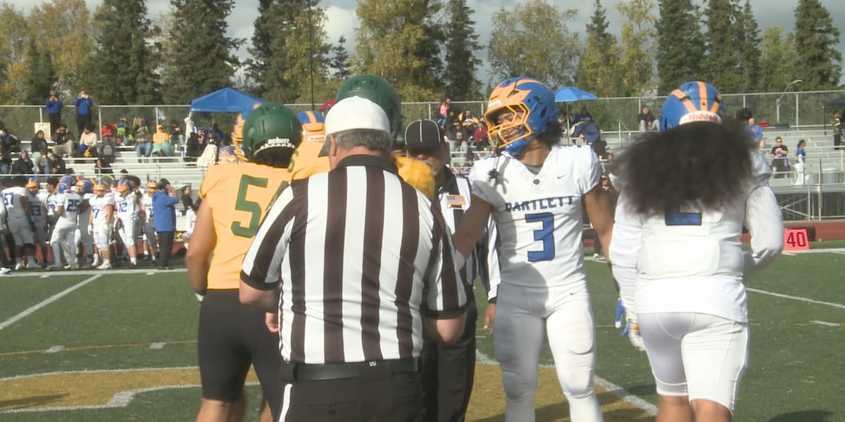
ANCHORAGE, Alaska (KTUU) – As the playoffs inch closer, each successive week of high school action carries more seeding implications and general importance – and one could tell as much from watching the slate of games this weekend.
Every team in the state was active this week except Seward in 9-man, giving plenty of opportunities for statement performances at every level.
Bartlett 12 – Service 6 (3OT)
Service played host to Bartlett looking to extend its record to 5-0, but couldn’t survive a chaotic, back-and-forth game that featured 12 combined turnovers and defensive dominance on both sides.
Golden Bears standout Deuce Alailefaleula notched a first-quarter interception and fell on an errant Service snap to tie the game at 6 late in regulation. After two overtime frames with no scoring, Bartlett back Colt Jardine plunged in for the walk-off touchdown on the first play of triple-OT.
Dimond 25 – Colony 22
The Dimond Lynx invaded a wet and wild Pride Field to take on Colony, and weathered the storm by scoring 19 unanswered points to eke out their first win of the season.
Colony fans huddled underneath tents and umbrellas watched in horror as Dimond surged ahead on a late touchdown strike, before the Knights’ last-gasp drive ended in a sack.
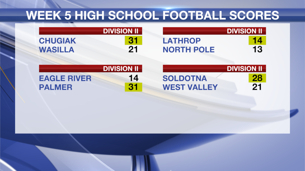
Eagle River 14 – Palmer 31
Though it was a much tighter contest most of the way than the final score would indicate, Palmer’s high-powered offense continued to produce in a similarly rainy matchup with Eagle River.
Twenty-four unanswered Moose points helped Palmer extend its winning streak to four, and secured its first 4-1 start since 2013.
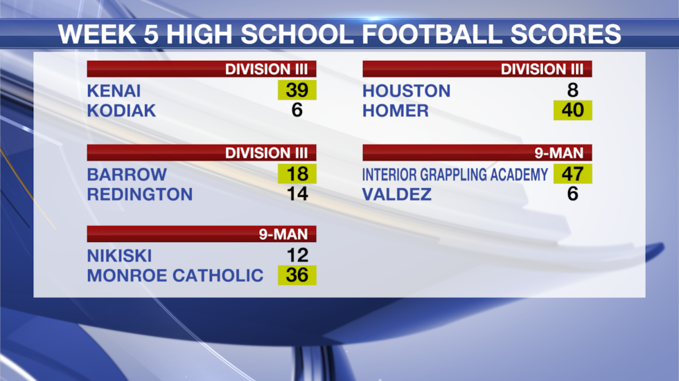
WEEK 5 HIGH SCHOOL FOOTBALL SCORES
See a spelling or grammar error? Report it to web@ktuu.com
Copyright 2025 KTUU. All rights reserved.
Alaska
UPDATE: 911 outage continues in Anchorage

ANCHORAGE, Alaska (KTUU) – The Anchorage Police Department said an outage continues to impact the Anchorage 911 system.
It continues to encourage people in Anchorage who need to use the service to dial 3-1-1 and select option one, or call (907) 786-8900 to connect with police.
ORIGINAL: Anchorage is experiencing a 911 and voice service outage, Alaska Communications told Alaska’s News Source Friday evening.
Alaska Communications spokesperson Heather Cavanaugh said disruption involves home and business landline service as well as 911 calls in Anchorage.
Technicians are working to restore service, but there is no estimated time for when it will be back online, Cavanaugh said. The cause has not been identified, though crews are investigating the source.
“Technicians are still on site working to restore service as quickly as possible,” Cavanaugh said at about 9:40 p.m. Friday night.
Police urged residents to use alternative numbers to reach emergency dispatchers while the outage continues. Anchorage residents can dial 3-1-1 and select option one, or call (907) 786-8900 to connect with police.
Anchorage police first reported a statewide outage late Friday afternoon. Alaska Communications confirmed this evening that the issue is limited to the greater Anchorage area.
See a spelling or grammar error? Report it to web@ktuu.com
Copyright 2025 KTUU. All rights reserved.
-

 World1 week ago
Trump and Zelenskyy to meet as Poland pressures NATO on no fly zone over Ukraine
-

 Technology1 week ago
New Evite phishing scam uses emotional event invitations to target victims
-

 Health1 week ago
Diabetes risk quadruples with use of popular natural remedy, study finds
-
 Politics1 week ago
House plans Thursday vote on government funding bill to extend spending through November
-

 Business1 week ago
Disney, Universal and Warner Bros. Discovery sue Chinese AI firm as Hollywood's copyright battles spread
-

 Health1 week ago
Who Makes Vaccine Policy Decisions in RFK Jr.’s Health Department?
-

 Finance2 days ago
Reimagining Finance: Derek Kudsee on Coda’s AI-Powered Future
-

 Lifestyle1 week ago
Bobbi Brown doesn’t listen to men in suits about makeup : Wild Card with Rachel Martin

