Connect with us

Oklahoma

Fall Weather Arrives: A Blustery, Wet Pattern Developing For The Weekend

Published

on

Fall Weather Arrives: A Blustery, Wet Pattern Developing For The Weekend


What is the weather like in Oklahoma on Friday?

Temps are expected to drop behind the frontal passage as north winds bring cooler weather into the area. The metro showed temps in the lower 70s Friday morning, but temps dropped into the lower 50s by the early afternoon. They should drop again into the upper 40s Friday night. Locations along and south of I-40 will drop into the lower 60s this afternoon and then into the lower 50s around sunset.

After the front clears out the area on Friday, most showers and storms will be across the Red River Valley region later tonight. We anticipate dry conditions for most of tonight across the northern areas of the state.

Advertisement

What Will the Weather Be Like This Weekend?

The exact position of the stalling front holds the key to temperatures for Saturday, but we expect a very chilly and occasionally wet day for most of the area on Saturday and an even colder Sunday.
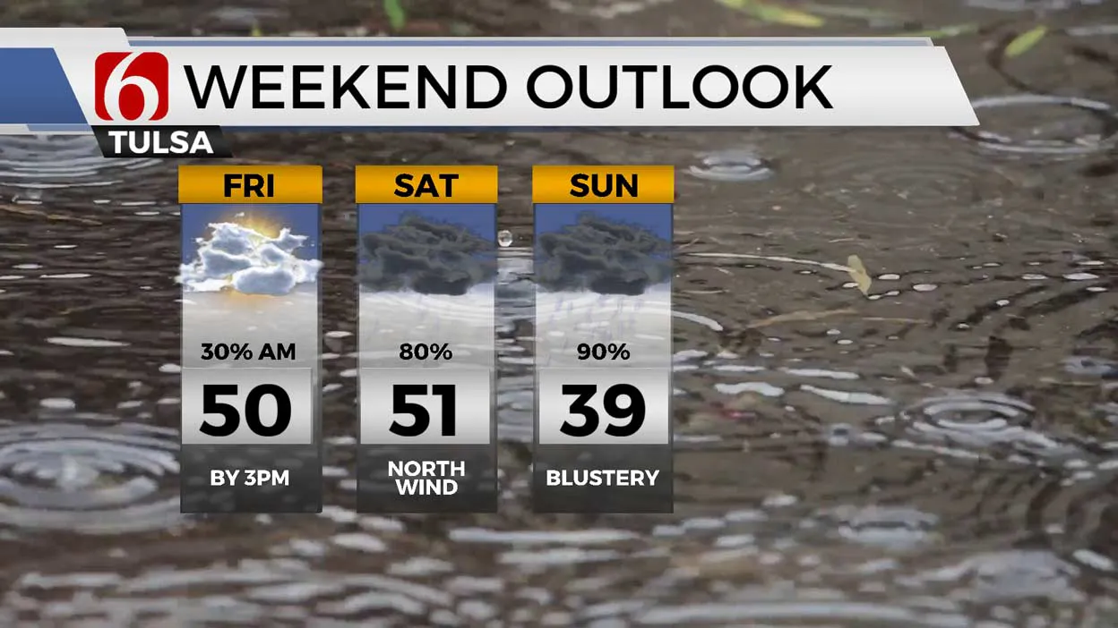
Weekend Outlook 10-28/29

The front is expected to stall across the Red River Valley tonight and may nudge slightly northward Saturday morning through midday, mostly still south of the I-40 corridor.

Saturday morning lows will be in the 40s for most of the area. The main upper-level long wave trough will keep a strong southwest flow atop the cooler air at the surface resulting in periods of overrunning precipitation.

Locations near and slightly north of the surface boundary may see some thunder also mixed in with the showers. No severe weather will occur, but some pockets of moderate to occasionally heavy downpours will be possible Saturday near this boundary.

Due to recent rainfall in these areas, southeastern OK will be monitored for some localized flooding issues. No flood watches are posted currently for this region.

Advertisement

More northward, the overrunning precipitation may not be quite as heavy. After some spotty showers during the early morning hours, precipitation will gradually increase to higher coverage midday into the afternoon and evening hours.

High temps across northern OK may stay in the upper 40s and lower 50s. Locations along the I-40 corridor will be in the mid-50s, with far southeastern OK in the 60s.

A strong Canadian surface ridge of high pressure builds across the northern high plains Saturday evening and expands southward bringing even colder air into the state Sunday.

What is the Forecast for Sunday?

This is effectively another cold front. North winds at 20 to 30 mph will be likely with temperatures staying in the lower 40s through Sunday morning and dropping into the upper 30s by afternoon. Wind chill values are expected to drop into the upper 20s by Sunday afternoon and evening.

The main upper air long wave trough will continue to bring southwest flow over the colder air mass resulting in a saturated layer. This will bring precipitation to a large area for most of the day. At times this may be in the form of drizzle and other times cold light showers.

Advertisement

Locations across far northwestern OK into southwestern Kansas may be cold enough for some light wintry precipitation Sunday, but not across our northeastern sections of the state. The trough will exit the area Sunday evening quickly taking precip out of the area.
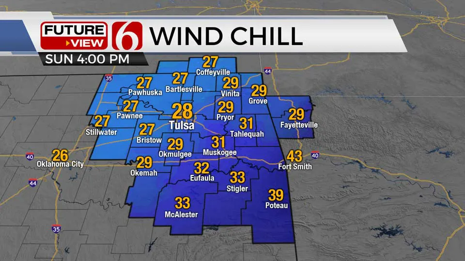
Sunday Wind Chill

As the clouds clear Sunday evening, temps will drop into the upper 20s and lower 30s by Monday morning prompting the possibility of a freeze or frost across the northern sections of the state.

Sunshine and highs in the upper 40s north and lower 50s south will remain for the afternoon with north winds at 10 to 15 mph. Excellent radiational cooling is likely to occur Monday night bringing cold air.

Many locations will drop in the mid and upper 20s followed by highs in the lower 50s Tuesday afternoon. Another front is possible Tuesday evening. Another area of freezing temps, possibly in the lower 20s in some valleys, with the metro in the mid to upper 20s, will be followed by highs Tuesday afternoon in the upper 40s and lower 50s.

Trick-or-treating hours will be cold, mostly in the 40s, but with light north winds and dry weather.

Advertisement

Click here for Alan Crone’s weather podcast

Follow the News On 6 Meteorologists on Facebook!

Meteorologist Travis Meyer

Meteorologist Stacia Knight

Meteorologist Alan Crone

Advertisement

Meteorologist Stephen Nehrenz

Meteorologist Aaron Reeves

Meteorologist Megan Gold

————


Source link

Advertisement
Continue Reading
Advertisement
Click to comment

Leave a Reply

Your email address will not be published. Required fields are marked *

This site uses Akismet to reduce spam. Learn how your comment data is processed.

Oklahoma

Oklahoma Sooners add another transfer portal quarterback

Published

on

Oklahoma Sooners add another transfer portal quarterback


The Oklahoma Sooners made a splash via the transfer portal when they added former Washington State quarterback and the top player in this year’s portal class, John Mateer. But the Sooners weren’t done at quarterback, adding Western Carolina signal caller Cole Gonzales.

Gonzales started 22 games in three seasons with the Catamounts, completing 63.5% of his passes for 6,445 yards, 49 touchdowns, and 20 interceptions. On non-sack rushing attempts, Gonzales averaged 5.4 yards per carry and ran for 701 yards and three touchdowns.

In 2023, he was the 2023 Southern Conference Player of the Year and was a two-time first-team All-Conference selection. Last year, he completed 66.1% of his throws for 2,547 yards, 26 touchdowns and threw just six interceptions in 11 games. That year, Gonzales threw for five touchdown passes three times and six games with more than 250 yards passing.

In 2024, he completed 61.7% of his passes for 2,545 yards and 12 touchdowns and threw seven interceptions this season. Gonzales was really efficient in the deep passing game, with a 45.5% completion percentage on throws greater than 20 yards down the field. That was good for sixth in the FCS among quarterbacks with at least 44 pass attempts on deep throws.

Advertisement

In the 2024 season opener against N.C. State, Gonzales threw for 211 yards and two touchdowns, completing 62.9% of his passes. He also carried the ball six times for 78 yards, according to Pro Football Focus, who removes sacks from rushing totals.

Against Furman, in week eight of the 2024 season, Gonzales threw for 620 yards and five touchdowns.

In Gonzales, the Sooners add more quarterback depth to the roster to go along with Mateer, Michael Hawkins Jr., and 2025 signee Jett Niu. He’ll have one year of eligibility remaining in 2024.

Contact/Follow us @SoonersWire on X, and like our page on Facebook to follow ongoing coverage of Oklahoma news, notes, and opinions. You can also follow John on X @john9williams.


Source link

Advertisement
Continue Reading

Oklahoma

What will the weather be like on Christmas Day in OKC? See 2024 Christmas forecast

Published

on

What will the weather be like on Christmas Day in OKC? See 2024 Christmas forecast


play

Oklahoma City won’t have a white Christmas in 2024, but we also won’t be breaking any high temperature records.

Advertisement

Here’s what you need to know about the Christmas forecast in OKC and across Oklahoma.

Oklahoma Christmas 2024 forecast

According to the National Weather Service, it will be cloudy but dry on Christmas Day in Oklahoma.

A chance of rain will increase in the late evening hours.

Advertisement

Here are the forecasted highs and lows across central, western and northern Oklahoma:

  • Oklahoma City: Low of 44°F, high of 52°F
  • Enid: Low of 36°F, high of 50°F
  • Lawton: Low of 46°F, high of 57°F
  • Woodward: Low of 30°F, high of 52°F
  • Ada: Low of 46°F, high of 56°F


Source link

Continue Reading

Oklahoma

Former Oklahoma State DC Bryan Nardo Expected to Join Charlotte Staff

Published

on

Former Oklahoma State DC Bryan Nardo Expected to Join Charlotte Staff


Oklahoma State’s former defensive coordinator is wasting no time finding another gig.

On Monday, Doug Samuels of FootballScoop reported that Bryan Nardo is expected to join the defensive staff at Charlotte. One of the most recent teams to jump to the FBS level, Charlotte could soon be adding a coach with Big 12 experience.

Nardo spent the past two seasons in Stillwater as the Cowboys’ defensive coordinator. While his first season wasn’t necessarily the most impressive, it seemed his adjustments and overall scheme were key in OSU’s ascension to a 10-win season and Big 12 Championship appearance.

However, everything fell apart for Nardo in year 2. With the Cowboys ranking among the bottom 10 in the FBS in most statistical categories, OSU’s defense was the main issue in the team’s winless Big 12 campaign.

Advertisement

However, not all of the blame for OSU’s three-win season can be placed on Nardo. OSU’s offense also struggled mightily throughout the season, but the injuries piling up for the OSU defense sealed Nardo’s fate.

With future NFL players Collin Oliver and Nick Martin not playing a snap after September, the Cowboys were without their anchors and other injuries piled up from there. With a myriad of backups and players not playing in their natural positions, Nardo had no true opportunities to run his desired scheme. Still, OSU’s horrendous rankings and results on the field were still too much to overlook as the team overhauled virtually its entire staff this offseason.

With Nardo heading east, the Cowboys hired Todd Grantham as his replacement shortly after the position opened. Nardo is also not the first former OSU defensive coordinator to head to Charlotte.

After being let go following the 2017 season, Glenn Spencer went to Charlotte and was its defensive coordinator for the 2018 season.

Want to join the discussion? Like Oklahoma State Cowboys on SI on Facebook and follow us on Twitter to stay up to date on all the latest Cowboys news. You can also meet the team behind the coverage.

Advertisement


Source link

Continue Reading

Trending