Florida
Why has Central Florida been getting so much rain lately?

ORLANDO, Fla. – Yes, there’s a rainy season for Central Florida. Climatologically, the rainy season begins in late May and lasts through the middle of October and it can vary year to year. The summer heat, humidity and seabreezes (which are differences in temperatures between the ocean waters and land) make up the perfect recipe for thunderstorms to develop across east Central Florida.
Lately, we’ve been seeing daily thunderstorms produce heavy rain, which has led to flooding in a few areas and strong gusty winds with other modes of storm threats. Well, it’s actually typical and expected for this time of the year.
Rainy season for east Central Florida began in late May, and it lasts through the middle of October. But what’s also interesting is that we’ve been stuck under a very unusual weather pattern for the last several days.
An upper-level low has been stuck north of the area with a cold front which has been stalling out now and again. This type of weather setup helps thunderstorm development and it keeps our weather pattern unsettled.
[TRENDING: Become a News 6 Insider]
A combination of the sea breezes, hot-and-humid air and that upper-level low has been resulting in thunderstorms continuing to fire up daily.
During the summer months, cold fronts come to a halt in our area. With little to no cold front moving through, the sea breezes continue to increase the moisture in the atmosphere. So when thunderstorms get going, there’s plenty of moisture for the storms to tap into to produce heavy rain.
While nuisance flooding has been happening lately in a few areas, one county has been dealing with the relentless rain for the past several days and saw record rainfall a few days ago. Ocala picked up 4.39 inches of rainfall on Tuesday, which was record-breaking.
That amount of rain and the daily rainfall prior led to major flooding problems in that area. Marion County has been under a Flood Watch for the past couple of days due to the daily heavy rainfall.
Other counties across Central Florida have also been dealing with nuisance street flooding in the past couple of days. Some spots were picking up a couple of inches daily. In the past 12 hours, some areas picked up between 1-2 inches, according to the radar.
With more than 50 years of rainfall data collected by the National Weather Service, it has been determined that the median date for the rainy season for a few cities is as follows.
The end of the wet season for Orlando and Daytona Beach is Oct. 15. The end of the rainy season for Melbourne and Vero Beach is Oct. 17.
Copyright 2023 by WKMG ClickOrlando – All rights reserved.


ORLANDO, Fla. – A large surface high will continue to build in over the eastern seaboard, promoting warmer and drier conditions Wednesday and Thursday across Central Florida.
With a steady onshore flow, a dominant east coast sea breeze is forecast to push inland Wednesday afternoon, keeping a few isolated showers developing inland. Coverage both days stands at 5-10%.
Afternoon temperatures are expected to warm up a bit on Wednesday — into the upper 80s along the coast and the low 90s further inland.
By the Memorial Day holiday weekend, temperatures will soar to near record highs, reaching the upper 90s west of I-95 and the upper 80s along the coast. Heat index values are forecast to run between 97-102 degrees on Friday, and to 100-107 degrees by Monday, nearing heat advisory criteria.
As you prepare and plan for your long holiday weekend festivities, remember to have ways to stay cool. Make sure you take frequent breaks in the water or in other cooler places while remaining hydrated.
Rain chances through the outlook remain low at 10-20%.
Tropical Update
The latest tropical outlook shows no tropical development expected in the next two to seven days. Hurricane season officially begins in 10 days.
On Thursday, NOAA will issue its official 2024 Hurricane Season forecast.
Copyright 2024 by WKMG ClickOrlando – All rights reserved.

WACO, Texas (KWTX) – Baylor softball is heading to the super regionals for the seventh time in program history.
The Bears will be up against fourth-ranked Florida in Gainesville. Baylor is embracing the underdog role.
“Not only are they not picking us to come out, they’re picking us to lose in two games. We thrive in that type of pressure,” said Baylor softball coach Glenn Moore.
Baylor’s advancing after getting out of the regionals in Lafayette, Louisiana. For the seniors, the idea of reaching the college world series is extra special.
“Now you have the biggest possible thing to look at. We could play at the world series. Having that in the back of your mind is huge,” said Emily Hott, Baylor senior.
Baylor will play Florida on Friday at 11 a.m.
Copyright 2024 KWTX. All rights reserved.

MIAMI-DADE COUNTY, Fla. – A flood advisory and severe thunderstorm warning were issued for a portion of Miami-Dade County on Tuesday.
The advisory is in effect until 6 p.m. after the National Weather Service reported that up to two inches of rain had fallen throughout the day. The severe thunderstorm warning is in effect until 5:30 p.m.
Additional rainfall amounts of one to two inches are expected in areas that include Miami, Hialeah, Hollywood, Miami Beach, Surfside, Hallandale, Virginia Key, Miami Gardens, North Miami, North Miami Beach, Aventura, Miami Lakes, Sunny Isles Beach, Opa-locka, West Park, Miami Shores, North Bay Village, El Portal, Gladeview and Westview, according to the NWS.
Nickle-sized hail fell in Pinecrest Tuesday afternoon as thunderstorms continued to scatter through the area.
A Local 10 viewer sent video showing the hail coming down at a heavy pace at Centris, a neighborhood in Pinecrest, located near the 8200 block of Southwest 120th Street.
Drivers are advised to remain indoors as the heavy rain and winds continue through Miami-Dade County.
Local 10 Meteorologist Peta Sheerwood said the storms are expected to subside around 7 p.m.
According to the NWS, wind gusts can reach up to 60 mph and quarter-size hail are possible.
The NWS advises that South Florida residents and visitors should always remain alert for a possible tornado and be prepared to seek immediate shelter.
Click here to view Local 10′s Hurricane Survival Guide. To receive updated hurricane news and analysis from Local 10′s weather team, click here.
Related media
Copyright 2024 by WPLG Local10.com – All rights reserved.

Maternal mortality, The Voice, drone arrest: Down in Alabama

Why water in many Alaska’s rivers is turning orange – Times of India

Secure cages and Swat teams: Arizona county’s drastic steps to protect the vote

Arkansas baseball bracketology: Where Hogs stand in 2024 NCAA Tournament bracket projections

California pays meth users to get sober
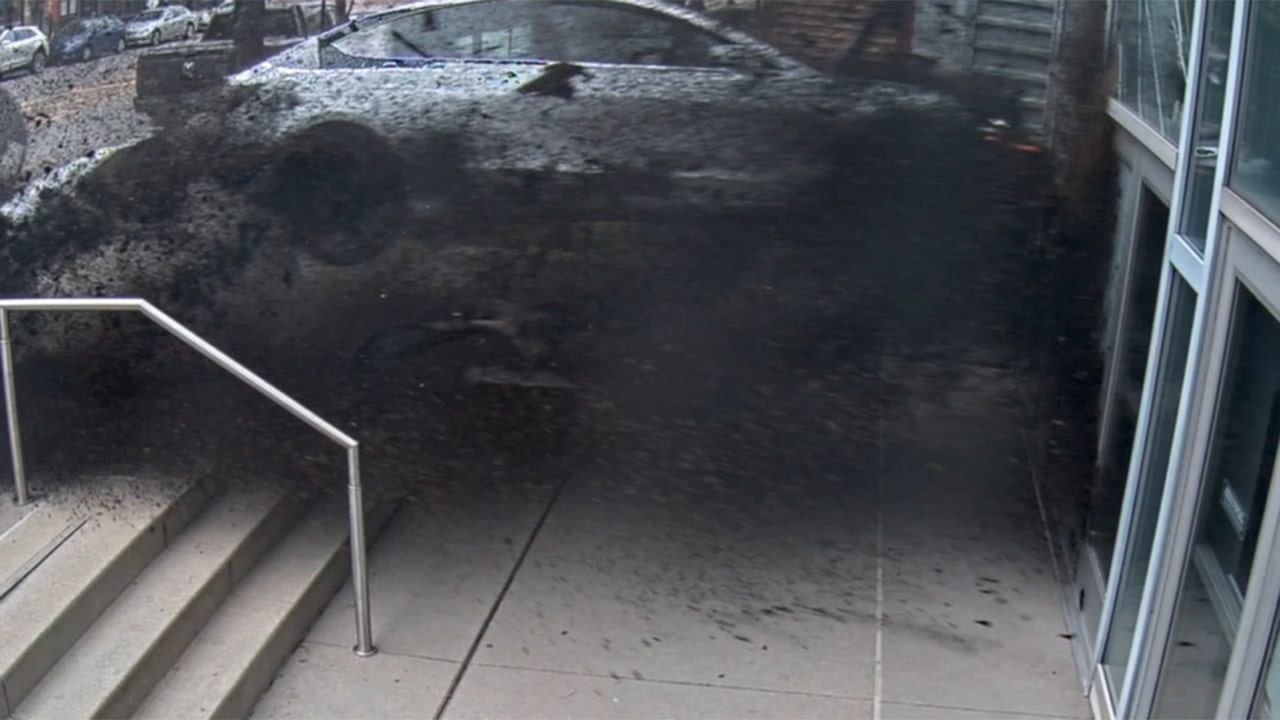
See it: Tesla crashes into Columbus convention center at 70 mph

Colorado Rockies game no. 116 thread: Zac Gallen vs José Ureña

Fox News Politics: Georgia the whole day through

Death of missing Oregon girl found in stream ruled homicide

At least 2 dead as tornadoes hit Alabama, damage homes across Southeast

Video: Midwest Storms Destroy Homes

Michael Cohen swore he had nothing derogatory on Trump, his ex-lawyer says – another lie – as testimony ends

Norway will recognise Palestinian state, PM says

Vince Fong wins special election to finish term of former House Speaker Kevin McCarthy

Read Prosecutors’ Filing on Mar-a-Lago Evidence in Trump Documents Case
-
 News1 week ago
Skeletal remains found almost 40 years ago identified as woman who disappeared in 1968
-
 World1 week ago
Ukraine’s military chief admits ‘difficult situation’ in Kharkiv region
-
 Movie Reviews1 week ago
Aavesham Movie Review
-
 World1 week ago
Catalans vote in crucial regional election for the separatist movement
-
 Education1 week ago
Video: Protesters Scuffle With Police During Pomona College Commencement
-
 World1 week ago
EU's divided right wing can disrupt if it finds greater unity: experts
-
 News1 week ago
Nevada Cross-Tabs: May 2024 Times/Siena Poll
-
 News1 week ago
Controlled demolition planned at Baltimore bridge collapse site