Connecticut
Donny Osmond’s summer tour – first stop Connecticut

Connecticut fans of Donny Osmond won’t have to travel to Las Vegas to experience the singer’s long-running popular stage show currently headlining at Harrah’s Casino.
Tickets recently went on sale for Osmond’s summer tour that kicks off at the Waterbury Palace Theater on July 18. The 70s teen idol returns two weeks later (August 3) for an appearance at the Foxwoods Resort Casino in Ledyard (see www.donny.com).
“I’ve visited Connecticut many times over the years,” said Osmond from Las Vegas. “I did a (2008) movie called ‘College Road Trip’ that was shot in a number of Connecticut towns. And I’ve played at Foxwoods many times, it’s such a great facility.”
The summer tour, his first in almost seven years, comes straight from the Las Vegas stage where he recently celebrated the 200th performance.
“I’m taking it across the country for people who can’t get to Las Vegas,” he explained. “I’m bringing the entire company – singers, dancers, musicians, and a full video production. I’m really looking forward to it because I was born on the road!”
While longtime fans remember Osmond as part of the Osmond family singers, not to mention the “Donny & Marie” variety show from the 70s, the “Donny & Marie” daytime talk show in the late 90s, and a string of musical theater roles on Broadway, Osmond has continued to reinvent himself to keep up with the changing times.
He hosted a TV game show (“Pyramid”) in the early 2000s, was a runner-up in the first season of Fox’s “The Masked Singer” in 2019, and won season 9 of ABC’s “Dancing with the Stars” a decade earlier.
“That was probably the hardest thing I’ve ever done in my life,” he said. “And to win the trophy was probably one of my favorite accolades.”
For the Utah native, those accolades began at the age of 5 when he joined four of his brothers in 1963 on “The Andy Williams Show” singing his debut song “Yes Sir, That’s My Baby” on Williams’s lap. Later in the program, he belted out his first solo performance on television, “You Are My Sunshine.”
“I remember doing the show and have a lot of respect for that man because he gave me my start,” recalled Osmond. “In fact, I do a duo with Andy Williams singing ‘Moon River’ on the big screen behind me in the show. It’s become a very emotional part of the evening and people tell me quite a tearjerker. It’s included in my rap song that looks back on my career.”
Wait, the kid who tore up the pop charts in the early 70s with hit singles such as “Go Away Little Girl,” “Puppy Love,” and “Too Young,” not to mention recording 65 albums over his career, does rap?
“I sure do,” said Osmond, laughing. “It’s become one of the most popular parts of my show where I do a 10-minute rap in front of a big screen video projection outlining my six-decade career. I came up with the idea and remember telling the show’s director who said, ‘I’d pay money to see Donny Osmond rap!’ With the fast-paced video and photos, it’s almost data overload and has become a fan favorite segment of the show.”
Like many entertainers, Osmond’s career had its low points and these are not excluded from his biographical rap review. “I did one Broadway show that opened and closed on the same day!”
Another favorite Osmond song for younger fans is “I’ll Make a Man Out of You” from Disney’s 1998 film “Mulan.” While appearing in a Chicago stage production of “Joseph and the Amazing Technicolor Dreamcoat,” Osmond was spotted by Disney and was asked to join the vocal cast for their new animated feature.
“We turn the whole theater into a ‘Milan’ moment with a 6-minute full production number including a stick fighting dance on stage and my character, Captain Shang, on the big screen behind me,” said Osmond. “I had no idea the song would become a Disney classic.”
Of course, not everyone is a Donny Osmond fan and the 65-year-old singer often chuckles when he looks out into the audience during a show.
“My audience has always been predominantly female, but it’s quite interesting what’s happened in the last five years or so,” notes Osmond. “Recently, there was a bearded guy in the front row who looked like one of those Grateful Dead Deadheads and by his attitude I could tell his wife had dragged him to the concert! But at the end of the show, he was the first on his feet to give me a standing ovation. So it’s very satisfying to win over people like that. I’m sure audiences on the summer tour will not only enjoy the music but learn about what I’ve accomplished over my six-decade career.”
Nick Thomas has written features, columns, and interviews for numerous magazines and newspapers. See www.getnickt.org.


Rocky Neck State Park remains closed after fire broke out on a hiking trail on Saturday.
The park and trail system remain closed as crews work to manage the fire, according to the state Department of Energy and Environmental Protection. The park will be closed until further notice.
🔥 Due to fire management operations, Rocky Neck State Park is closed until further notice. This includes the extensive trail system. 🥾https://t.co/hTyqADYHkW@CTStateParks pic.twitter.com/coIHaHCek0
— DEEP (@CTDEEPNews) November 4, 2024
Firefighters are battling several fires across the state amid dry conditions and a statewide emergency burn ban is in effect.
Outdoor grills, fire pits, campfires, kindling and use of flame are not allowed in any state parks, forests or other state-owned public lands. The ban also includes smoking and using lighters outdoors.
The Enduro Trail in Voluntown and parts of North Stonington within the Pachaug State Forest are also closed.
Gov. Ned Lamont on Oct. 25 declared a state of emergency because of fire conditions.

Authorities say there are potentially more challenges coming up this week and it could be months before the state is really out of the woods when it comes to the fire danger.
“We’re just trying to keep the residents of Connecticut safe,” said Rich Schenk, the fire control officer for the Department of Energy and Environmental Protection.
Burn bans are still in place as the state deals with dozens of fires.
A few new ones popped up on Sunday bringing the total to 111 being tracked statewide.
“Without rain, the ground is getting drier. The leaves, it’s like walking on potato chips out there,” Schenk said.
Firefighters are battling a fire in Rocky Neck State Park that has burned about 46 acres.
The park remains closed for public safety.
At the largest blaze in the state – the Hawthorne Fire in Berlin – there is promising news.
“We’re going to transition into more from the mop up phase to more of a patrol phase throughout this week,” said Chief Jonn Massirio, of the Berlin Volunteer Fire Department.
The fire is now considered 50% contained after scorching 127 acres.
But the coming days could bring warmer temperatures, gustier winds, and more red flag warnings.
“We’re still going to keep our guard up. They’re not gonna, you know, put our heads down. Still got to be vigilant. Across the state. Conditions still persist to be dry,” Massirio said.
Crews from outside the state have been called in to help. They could be here until December or January.
“We’re going to need some kind of weather pattern that changes what we’re in until we get some southern moisture coming up. I want to plan for the worst case scenario so that the state’s prepared and I don’t want to be caught shorthanded,” Schenk said.
At least at the Hawthorne Fire, crews are hopeful the fire containment can be increased this week.

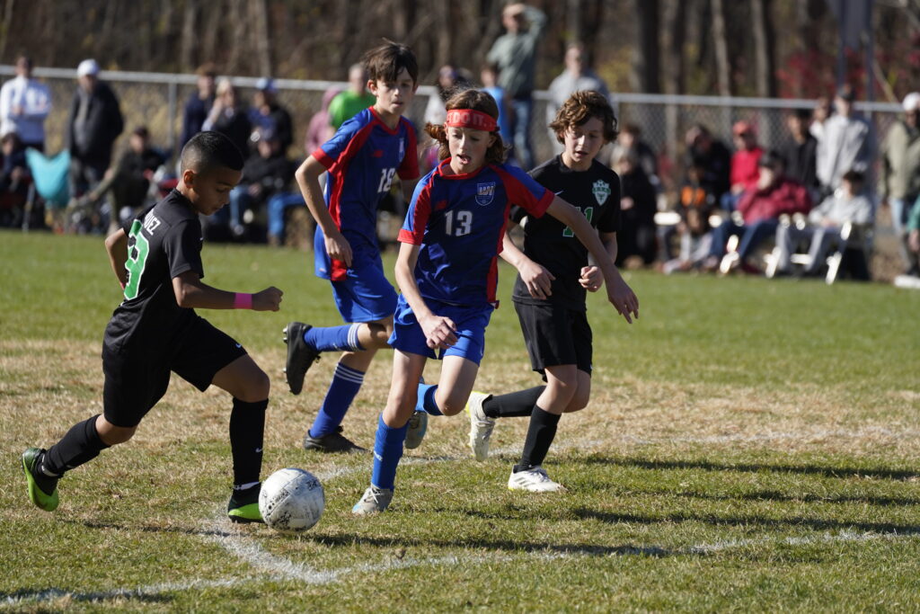
The West Hartford U12 Boys Travel Soccer team won the Fall 2024 Connecticut Cup on Nov. 2, 2024.
he West Hartford U12 Boys Travel Soccer team won the fall 2024 Connecticut Cup. Courtesy photo
Submitted
The U12 Boys Travel Soccer team from West Hartford defeated Enfield 2-1 on Saturday, Nov. 2, winning the Connecticut Cup Championship for the second year in a row.
Nick Hunt, a student at King Philip Middle School, scored both goals for West Hartford. Keeper Dallas Dodge IV had eight saves to secure the win.
In the fall of 2023, as a U11 team, they also won the Connecticut Cup.
The team is now coached by Erik Ribeiro, with Terry Phillip as assistant coach.
he West Hartford U12 Boys Travel Soccer team won the fall 2024 Connecticut Cup. Courtesy photo

he West Hartford U12 Boys Travel Soccer team won the fall 2024 Connecticut Cup. Courtesy photo

he West Hartford U12 Boys Travel Soccer team won the fall 2024 Connecticut Cup. Courtesy photo

The West Hartford U12 Boys Travel Soccer team won the fall 2024 Connecticut Cup. Courtesy photo
Like what you see here? Click here to subscribe to We-Ha’s newsletter so you’ll always be in the know about what’s happening in West Hartford! Click the blue button below to become a supporter of We-Ha.com and our efforts to continue producing quality journalism.

US supreme court to rule on new mostly Black Louisiana congressional districts

‘Too many deaths’: Retiring Maine police chief says stress took its toll

Maryland state champion Fort Hill forfeits five football games

Michigan health officials report rise in whooping cough cases

Drought expected to worsen, raising risk for dangerous brush fires in Massachusetts

Colorado Rockies game no. 116 thread: Zac Gallen vs José Ureña

See it: Tesla crashes into Columbus convention center at 70 mph

Fox News Politics: Georgia the whole day through

Death of missing Oregon girl found in stream ruled homicide

Why Marjorie Taylor Greene was ‘kicked out’ of the Freedom Caucus according to Rep. Buck

Trump keeps decrying rampant crime. Here’s how his misleading claim has shifted.

Trump camp confident based on early voting, while Black leaders say Harris is struggling

What happens if there’s a tie in the US presidential election?

Both Candidates Exude Confidence, Trump Says He Doesn’t Mind if Reporters Are Shot
")
Video: The County That Got Every President Right (Since 1980)
-
 Sports1 week ago
Freddie Freeman's walk-off grand slam gives Dodgers Game 1 World Series win vs. Yankees
-
 News1 week ago
Sikh separatist, targeted once for assassination, says India still trying to kill him
-
 Culture1 week ago
Freddie Freeman wallops his way into World Series history with walk-off slam that’ll float forever
-
 Technology1 week ago
When a Facebook friend request turns into a hacker’s trap
-
 Business3 days ago
Carol Lombardini, studio negotiator during Hollywood strikes, to step down
-
 Health4 days ago
Just Walking Can Help You Lose Weight: Try These Simple Fat-Burning Tips!
-
 Business2 days ago
Hall of Fame won't get Freddie Freeman's grand slam ball, but Dodgers donate World Series memorabilia
-
 Business7 days ago
Will Newsom's expanded tax credit program save California's film industry?