South
Alaskan community rebuilds while grappling with fatal landslide's impact

- A landslide struck Wrangell Island last November in southeast Alaska, killing six people, including a family of five.
- Wrangell’s community is slowly returning to normalcy with the upcoming tourism and seafood processing seasons.
- Alaska faces the threat of additional landslides due to an increase in intense rain.
Jamie Roberts and her husband felt lucky when they found an A-frame cabin on forest-draped Wrangell Island in southeast Alaska, where they could settle on a few acres and have some chickens.
A stretch of highway a few miles north, the only road into town, did make her nervous; there, waterfalls cascaded and rocks tumbled from towering bluffs on stormy days. But she always felt safe at her home of more than 20 years.
That all changed the night of Nov. 20 after heavy rains, when a torrent of earth and trees rushed down a mountainside next to their home, cutting a swath to the sea. It killed six people, including a family of five; demolished two houses; and buried the highway.
DEATH TOLL IN ALASKA LANDSLIDE CLIMBS TO 3; 3 OTHERS STILL MISSING
The landslide lacked the scale of one that erased a neighborhood in Oso, Washington, 10 years ago this Friday. But it, too, left a community unmoored, wondering whether the dramatic landscape above was as permanent as it once seemed.
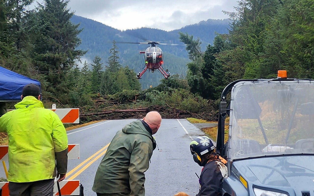
This photo shows a helicopter arriving near the Zimovia Highway where ground teams, including search and rescue dogs, actively searched following a fatal landslide on Nov. 22, 2023. Last November, a landslide struck Wrangell Island in southeast Alaska, killing six people, including a family of five. (Willis Walunga/Division of Homeland Security and Emergency Management via AP, File)
Roberts and her family have moved from their home and only returned for brief visits.
“I don’t know that we’d ever sleep very well going back there,” she said.
In some ways, life in Wrangell, a former logging town, is returning to normal. The summer tourism and seafood processing seasons are approaching, and the boys’ varsity basketball team this month competed at state. The highway has been rebuilt.
But trees and other debris still dotted the tidelands and lower portions of the snow-covered scar on a recent day.
That scar is visible from the driveway of Stephen Todd’s waterfront home. Todd, his wife and their dog, Festus, moved back last month after staying closer to town after the slide.
“There were no signs of instability” on that slope before, said Todd, a biologist. “I mean, it’s steep country, but every place is steep country in southeast Alaska.” He and his wife won’t stay in their home when the forecast calls for intense rain.
Rain is a part of life in the region, most of which is nestled in the Tongass National Forest, a temperate rainforest. Communities have long co-existed with landslide risks: In Alaska’s capital, Juneau, the downtown core and tourist district are built into or are at the base of mountains. Thousands of landslides have been documented in the Tongass, though relatively few have been fatal.
But as the climate continues to warm, intense rains are expected to become more frequent in the region and other parts of the West Coast, heightening landslide risk. Researchers have blamed atmospheric rivers for landslides in southeast Alaska that killed three people in Sitka in 2015 and two in Haines in 2020.
After the Wrangell landslide, the state set up a drone operation and weather instruments on Roberts’ property to help officials identify warning signs. A second weather station is planned for the ridgeline above.
State and federal agencies hope to see more high-elevation weather stations installed in the region. The National Weather Service would like to use soil analyses from geologists to better understand how much rain it takes to increase a community’s landslide risk and incorporate that into weather alerts, said senior hydrologist Aaron Jacobs. But the work is intensive, and pulling it together will likely take years.
Wrangell is considering an online dashboard for residents that would use weather data to broadly assess landslide risk, similar to one developed after the Sitka slide, said Mason Villarma, Wrangell’s interim borough manager. Most of Wrangell’s roughly 2,040 people live on the north end of the island. But many homes farther out, along the highway, are built on slopes.
“We can’t tell people whether their property is safe or not. We want to definitely provide them the tools to make good decisions,” Villarma said.
Killed in November were Timothy and Beth Heller, along with their daughters Mara, 16, and Kara, 11. Their son Derek, 12, has not been found. Otto Florschutz, a neighbor, also died. His wife, Christina, survived.
Roberts, who coached Kara and Derek’s swim club, plans to participate in a race Kara wanted to do, in her honor. The club celebrated what would have been Derek’s 13th birthday recently with 13 laps, cupcakes and belly flops — things he would have loved, she said.
FIFTH PERSON CONFIRMED DEAD IN ALASKA LANDSLIDE; 1 STILL MISSING
For a long time, the sound of planes overhead upset Roberts: She thought the noise of the landslide was a jet that was about to crash. Until recently, she would close her eyes or bow her head to avoid seeing the scar on brief visits home to gather personal items.
The family moved four times in the days after the landslide. They need to be out of their current rental by April 1 but haven’t been able to find another house on the island they can afford. They anticipate having to sell their home and move out of state later this year.
Roberts has mixed feelings about selling. She’d be devastated if another family bought the home, only to suffer tragedy.
“Now I’m at the phase where I’m like, ‘It’s not fair,’” she said. “But we get to make the choice of what comes next. And other people didn’t.”

Kentucky
June unemployment rate shows slight increase in Kentucky Center for Statistics latest report


WATCH: Postgame interviews UL football HC, QB Lunch Winfield vs Marshall
Hear from UL football HC Michael Desormeaux and quarterback Lunch Winfield following the Cajuns’ 54-51 2OT win vs Marshall.
For the first offseason of his collegiate career, Lunch Winfield knew where he stood within Louisiana football.
The junior quarterback had spent the past two offseasons battling for the QB1 spot and losing that battle each preseason camp. This summer, Winfield has been handed the reins of the Ragin’ Cajuns offense and he’s hungrier than ever to lead them.
“I feel way more confident and ready to play at this point compared to other offseasons,” Winfield said. “I don’t even have the words, but I’m ready to play football. When there is fire, I thrive. And I’m just ready to get the team back to the standard that we need it.”
Louisiana football has role fit for Lunch Winfield
After being thrust into the starting role in 2025, Winfield proved he could be more than just a filler at the quarterback position. The 6-foot-2 and 225-pounder threw for 1,555 yards and 11 touchdowns, and was just as effective on the ground. Winfield led the Cajuns in rushing touchdowns with nine, racking up 667 yards rushing on 152 carries.
That breakout year quickly made the city of Lafayette fall in love with Winfield and he fell in love right back.
“Kids I take classes with are like in love with me, and just random day-to-day things happen that you would probably see in a movie or something,” Windfield said of the city embracing him. “It’s phenomenal to know that the people around Acadiana and Lafayette have my back and want to see me succeed.”
All spring and into the summer as QB1, Windfield has fallen right into a leadership role for the Cajuns both on and off the field. A role almost tailor-made for the happy-go-lucky slinger. With that position decided, fifth-year coach Michael Desormeaux will have one less question to answer.
“It’s allowed Lunch to be the leader he needs to be,” Desormeaux said. “It’s allowed him to not have to worry about his role and where he fits. He’s got unbelievable leadership qualities and being the guy for a full year just let’s him be comfortable to do what he needs to do for this team.”
With Winfield at the helm of their offense and an overall younger squad this season, the Cajuns are hoping for a better finish that the past year’s 6-7 record. A key, as it was last season, is the most important meal of the day: Lunch.
“As young as we are right now, it would mean a lot for Cajun Nation to see us winning,” Winfield said. “That’s when more people want to get involved with us and it keeps our team together. So we’re just trying to take it one step at a time, one week at a time to get where we want to be at in the conference championship.”
Shannon Belt covers high school sports, the Louisiana Ragin’ Cajuns and LSU men’s basketball for The Daily Advertiser as part of the USA TODAY Network. Follow her high school and Cajuns coverage on Twitter: @ShannonBelt3. Got questions regarding HS/UL athletics? Send them to Shannon Belt at sbelt@gannett.com.

Calling all outdoorsmen and women — Maryland’s Lower Shore is home to some of the best hiking, walking and running trails on the East Coast.
Here’s a closer look at four picturesque parks and preserves with nature trails in the Berlin, Salisbury and Ocean City area.
Assateague Island
Assateague Island offers a wide variety of paved and unpaved trails open for hiking and 37 miles of flat beach terrain for wandering and beachcombing. Assateague Island’s Maryland District features a Life of the Dunes trail, Life of the Forest trail, Life of the Marsh trail.
Furnace Town
Furnace Town is nestled between the Pocomoke State Forest and Nature Conservancy’s Nassawango Creek Preserve. The popular historical site offers three Nature Conservancy Trails, three Maryland Forest service Trails, and a 26-acre outdoor museum and recreation area.
Pemberton Historical Park
Pemberton Historical Park, a 262-acre area featuring a trail system, outdoor amphitheater and more, was created in the 1980s. The park offers 4.5 miles of nature trails for walking and hiking only, allowing visitors to explore wetlands, forests and more of the natural world.
Nassawango Creek Preserve
Nassawango Creek Preserve’s primeval forest has an abundance of bald cypress and black gum trees. Visitors are invited to indulge in its four trails, the Nassawango Joe, Prothonotary Warbler, Ron Wilson Memorial Trail and Leifer Trail, as well as self-guided audio tours.
Olivia Minzola covers communities on the Lower Shore. Contact her with tips and story ideas at ominzola@delmarvanow.com.
-

 Illinois4 minutes ago
Hillsboro grad, Springfield golfer Alex Eickhoff 2nd at state amateur
-
Indiana10 minutes ago
Where to watch Seattle Storm vs Indiana Fever on July 17: TV channel, start time and streaming
-

 Iowa16 minutes ago
US House Speaker campaigning in Iowa responds to President’s election fraud claims
-

 Kentucky28 minutes ago
June unemployment rate shows slight increase in Kentucky Center for Statistics latest report
-

 Louisiana34 minutes ago
How Louisiana football’s Lunch Winfield has embraced his QB1 role
-

 Maryland46 minutes ago
Great nature trails for hiking, beachcombing on Maryland’s Lower Shore
-

 Michigan52 minutes ago
Michigan’s upcoming Aug. 4 primary: What’s on my ballot?
-

 Massachusetts58 minutes ago
Noah Kahan Backs Massachusetts Bill Limiting Ticket Resale Prices

