Colorado
Significant Colorado snowstorm to impact Thanksgiving travel plans


Winter weather: What warnings, watches and advisories mean
The National Weather Service issues warnings, watches and advisories depending on conditions to alert the public.
A significant snowstorm will reach Colorado just in time to impact Thanksgiving travel.
If you can get to Colorado’s ski slopes before the storm arrives, you will enjoy some fantastic skiing.
Generally, travel conditions will be worse in the mountains and tapering to the Eastern Plains.
Here are details regarding the impending storm, according to the National Weather Service as of Monday morning:
Here is where and when winter storm warning is in place
- Winter storm warning: 3 a.m. Tuesday to 11 p.m. Wednesday with total snow accumulations between 10 and 20 inches for most areas, including the Front Range mountains; Park and Gore Ranges, including Rabbit Ears Pass, Rocky Mountain National Park, Medicine Bow Range, mountains of Summit County, Mosquito Range and Indian Peaks Wilderness. Road closures and very difficult travel conditions expected. Call 511 or visit cotrip.org for travel conditions.
Timing of the snowstorm and how it will impact travel
- Tuesday morning: Light to moderate snow begins for areas above 9,000 feet. Rain showers for lower elevations along the I-25 corridor.
- Tuesday afternoon/night: Heaviest snowfall expected to happen during this time in the mountains, especially above 10,000 feet, with mountain travel difficult over mountain passes. Light snow begins for areas above 7,000 feet with rain/snow mix possible for I-76 and I-25 corridor.
- Wednesday morning: Colder air arrives with lighter snow. Accumulation on roads could impact travel on the Eastern Plains and Palmer Divide.
- Thursday (Thanksgiving): Slick roads likely as roads freeze overnight, otherwise chilly and mostly dry.
Here are forecast snowfall totals for Fort Collins area and statewide
Wide snowfall total ranges are due in part because of when rain may turn to snow.
Larimer/Weld counties
- Fort Collins: 0-3 inches
- Loveland: 0-4 inches
- Wellington: 0-2 inches
- Windsor: 0-2 inches
- Greeley: 0-2 inches
- Berthoud: 0-4 inches
- Estes Park: 1-11 inches
- Red Feather Lakes: 2-9 inches
- Virginia Dale: 0-6 inches
- Cameron Pass: 12-26 inches
- Bear Lake (RMNP): 8-20 inches
- Milner Pass (RMNP): 11-25 inches
- Buckhorn Mountain: 1-9 inches
Other Colorado cities
- Denver: 1-2 inches
- DIA: 0-3 inches
- Boulder: 1-2 inches
- Castle Rock: 4-6 inches
- Colorado Springs: 2-3 inches
Colorado mountains/ski areas
- Steamboat Springs: 12-18 inches
- Winter Park: 18-24 inches
- Vail: 12-18 inches
- Aspen: 8-12 inches
- Breckenridge: 6-13 inches
- Breckenridge ski area: 15-34 inches
- Copper Mountain: 13-28 inches
- Keystone ski area: 13-26 inches
- Eisenhower Tunnel: 15-30 inches
- Berthoud Pass: 14-31 inches
- Loveland Pass: 14-27 inches
- Vail Pass: 13-25 inches
- Grand Lake: 7-15 inches
- Rabbit Ears Pass: 15-26 inches
Here is a look at the Fort Collins forecast for Thanksgiving week
- Monday: Sunny, with a high near 46 degrees, south-southeast wind 3 to 7 mph and low around 23.
- Tuesday: 30% chance of rain/snow mix until noon, then chance of afternoon rain, with little to no snow accumulation. Partly sunny, with a high near 49, southeast wind around 5 mph.
- Tuesday night: 70% chance of precipitation. Rain likely before 11 p.m., then rain and snow likely. New snow accumulation of less than a half-inch possible. Cloudy, with a low around 29 and northwest wind 3 to 6 mph.
- Wednesday: 50% chance of snow. Mostly cloudy, with a high near 39, north wind 7 to 14 mph, gusting to 21. 30% chance of snow before 11 p.m. Low around 16.
- Thursday (Thanksgiving Day): Sunny, with a high near 39 and low around 15.
- Friday: Sunny, with a high near 42 and low around 18.
- Saturday (CSU home football game): Sunny, with a high near 40 and low around 15.
- Sunday: Sunny, with a high near 39.


Colorado
Suddenly hazy skies in Denver prompt some residents concerned about wildfire smoke to call 911

Some people who live in the Denver metro area on Thursday afternoon were making calls to 911 after skies became noticeably hazy and winds kicked up. It was due to smoke from wildfires in Nebraska moving into Colorado. A cold front also was moving through the Front Range, and there is dust in the air.
The poor air conditions led to reduced visibility downtown after 3 p.m. Several of CBS Colorado’s City Cams showed dust or smoke in the air.
Temperatures were expected to drop by as much as 20 to 30 degrees with the cold front.
The suddenly dusty skies prompted at least one fire agency to put out a plea to residents to please only call 911 “if you see flames.” That warning was put out by South Metro Fire Rescue, which shared a photo on X of an office building with haze visible outside.
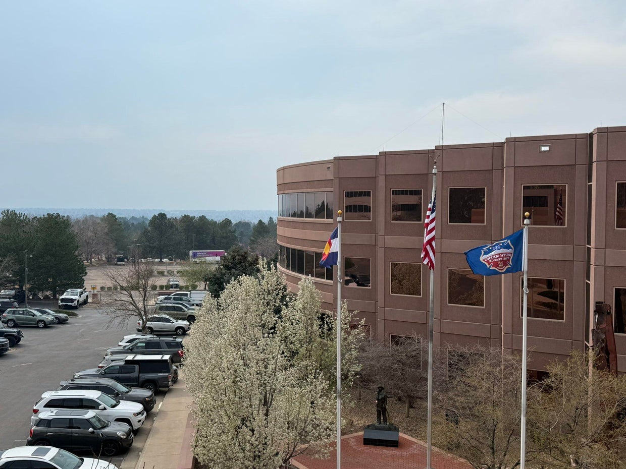
South Metro Fire Rescue said in their post that the smoke is from Colorado’s neighbor to the east. They called it a “significant haze” in the air.
Earlier this month, the Morrill Fire and the Cottonwood Fire burned a significant amount of Nebraska grassland and ranchland. They have mostly been contained by firefighters. Nebraska Gov. Jim Pillen said those two fires combined with several others have burned approximately 800,000 acres of land. On Thursday, Pillen announced that he is signing several executive actions intended to ease the burden caused by the fires.
There were no wildfires burning in the Denver metro area on Thursday afternoon.

ARAPAHOE COUNTY, Colo. (KKTV) – A homicide suspect based out of Colorado, wanted in a fentanyl-related death, is back in the state after being captured in Colombia.
The Arapahoe County Sheriff’s Office (ACSO) said 33-year-old Max Arsenault had been on the run since January 17.
Deputies said this stemmed from an incident in May 2023, where deputies responded to a call for a man named Nicholas Dorotik, who was found unresponsive.
ACSO said the cause of death was a mixed drug overdose involving meth and fentanyl, having about three times the lethal amount of fentanyl in his system.
One year later, Arsenault was arrested. He was scheduled for trial in January 2026 when deputies said he fled the country while on bond three days before the trial was set to start.
He was caught in Medellin, Colombia, on March 4, following a two-month international investigation. He has since been extradited back to Denver, where he is facing charges and awaiting trial.
Copyright 2026 KKTV. All rights reserved.


Merkley Announces Additional Oregon Town Halls April 2-4

Pennsylvania-born indie rockers Tigers Jaw return with new album release

A new safety role at Rhode Island College comes into sharper focus after Brown shooting – The Boston Globe

NFL Draft Injury Analysis: Jalon Kilgore, S – South Carolina

Retired Air Force four-star general Maryanne Miller speaks at South Dakota Mines

Florida High School Football Rankings: Top 25 teams – Oct. 21

How old is Bo Nix? What to know about Oregon quarterback ahead of 2024 NFL Draft

Cleary's 21 help Le Moyne down Central Connecticut State 69-64 in OT

99th annual Pony Swim held in Virginia

Indiana Members Credit Union announced as new anchor tenant at Bottleworks District

Video: Will ICE Change Under Its New Leader?

DHS shutdown breakthrough comes at cost for Republicans as funding fights nears end

Rubio joins crucial G7 talks as Iran war set to dominate second day

A surprise resignation could open the door for an independent to win a Montana Senate seat

Video: Savannah Guthrie Says She Believes Her Mother Was Taken for Ransom
-

 Detroit, MI1 week ago
Drummer Brian Pastoria, longtime Detroit music advocate, dies at 68
-

 Science1 week ago
How a Melting Glacier in Antarctica Could Affect Tens of Millions Around the Globe
-

 Movie Reviews1 week ago
‘Youth’ Twitter review: Ken Karunaas impresses audiences; Suraj Venjaramoodu adds charm; music wins praise | – The Times of India
-
 Science1 week ago
I had to man up and get a mammogram
-

 Sports6 days ago
IOC addresses execution of 19-year-old Iranian wrestler Saleh Mohammadi
-

 New Mexico5 days ago
Clovis shooting leaves one dead, four injured
-
 Business1 week ago
Disney’s new CEO says his focus is on storytelling and creativity
-

 Texas1 week ago
How to buy Houston vs. Texas A&M 2026 March Madness tickets