West Virginia
Snow totals for DC, Maryland, Virginia, and West Virginia from January 6, 2025

DC snow forecast: Record snowfall at BWI, Dulles Monday
A record snowfall at Baltimore/Washington International Thurgood Marshall Airport (BWI) and Washington Dulles International Airport (IAD) on Monday. A bitter cold day ahead with blowing snow possible.
WASHINGTON – The first significant snowfall of the season broke records across the Washington, D.C., Maryland, and Virginia region on Monday. Here’s a look at snow totals near you from the National Weather Service.
DMV SNOW TOTALS
DC SNOW TOTALS
Washington, DC snow totals
Washington 1 E: 6.8 inches (1000 PM 1/06, Trained Spotter)
Adams Morgan 1 SSE: 6.5 inches (730 PM 1/06, Trained Spotter)
Anacostia 1 S: 6.5 inches (930 PM 1/06, Trained Spotter)
School closures, delays for DC, Maryland, Virginia for Tuesday, January 7
Snow Totals for DC, Maryland, Virginia, and West Virginia from January 6
MARYLAND SNOW TOTALS
Allegany County snow totals
Ridgeley 1 NW: 6.5 inches (839 PM 1/06, Trained Spotter)
Bellegrove 1 SSE: 4.5 inches (816 PM 1/06, Trained Spotter)
Anne Arundel County snow totals
Londontowne 1 SSE: 10.3 inches (1130 PM 1/06, NWS Employee)
Birdsville: 9.1 inches (1200 AM 1/07, NWS Employee)
Crownsville 3 SSW: 8.7 inches (800 PM 1/06, Trained Spotter)
Chelsea Beach: 7.4 inches (1100 PM 1/06, Trained Spotter)
Pasadena 1 ENE: 7.3 inches (905 PM 1/06, Trained Spotter)
Crofton 2 NNE: 7.2 inches (700 PM 1/06, NWS Employee)
BWI Airport: 6.3 inches (700 PM 1/06, Official NWS Obs)
Glen Burnie 1 WSW: 6.1 inches (1004 PM 1/06, Trained Spotter)
Baltimore County snow totals
Pikesville: 7.7 inches (1009 PM 1/06, Trained Spotter)
Catonsville 1 SSE: 6.5 inches (900 PM 1/06, Trained Spotter)
Edgemere SE: 6.0 inches (805 PM 1/06, Trained Spotter)
Oella 2 NNE: 5.7 inches (1029 PM 1/06, Trained Spotter)
White Marsh 2 E: 5.5 inches (1100 PM 1/06, Trained Spotter)
Glyndon 1 WSW: 4.9 inches (1100 PM 1/06, Trained Spotter)
Upper Falls 1 NNE: 4.2 inches (1100 PM 1/06, Trained Spotter)
Long Green 2 NW: 3.5 inches (745 PM 1/06, Trained Spotter)
Bentley Springs 1 E: 3.0 inches (1000 PM 1/06, Trained Spotter)
Baltimore City snow totals
Arlington 2 E: 5.0 inches (1040 PM 1/06, Broadcast Media)
Calvert County snow totals
Benedict 1 E: 12.2 inches (827 PM 1/06, Public)
Prince Frederick 1 S: 11.6 inches (1010 PM 1/06, Trained Spotter)
Carroll County snow totals
Eldersburg 1 SE: 5.5 inches (1000 PM 1/06, Trained Spotter)
Sykesville 1 NNW: 5.2 inches (1030 PM 1/06, NWS Employee)
Gamber 1 WNW: 4.0 inches (1030 PM 1/06, NWS Employee)
Millers 4 NE: 3.8 inches (1200 AM 1/07, Co-Op Observer)
Charles County snow totals
Dentsville 1 SW: 10.1 inches (1000 PM 1/06, Trained Spotter)
Tompkinsville 4 WNW: 9.0 inches (1200 AM 1/07, Trained Spotter)
Welcome 2 WNW: 7.5 inches (724 PM 1/06, Trained Spotter)
Frederick County snow totals
Green Valley 1 WNW: 6.5 inches (850 PM 1/06, Public)
Fort Ritchie 1 SSE: 6.1 inches (828 PM 1/06, Trained Spotter)
New Market N: 5.3 inches (920 PM 1/06, Trained Spotter)
Mount Airy 1 WSW: 5.3 inches (1030 PM 1/06, Trained Spotter)
Bloomfield 2 WSW: 5.0 inches (900 PM 1/06, NWS Employee)
New Market 2 NW: 5.0 inches (800 PM 1/06, Trained Spotter)
Ballenger Creek WSW: 4.7 inches (1000 PM 1/06, Trained Spotter)
Garrett County snow totals
Grantsville 5 W: 14.8 inches (100 AM 1/07, Dept of Highways)
Mc Henry: 12.5 inches (852 PM 1/06, Trained Spotter)
Harford County snow totals
Aberdeen Proving Ground: 4.0 inches (1000 PM 1/06, Trained Spotter)
Churchville 1 N: 3.5 inches (1020 PM 1/06, Trained Spotter)
Forest Hill 3 SW: 3.3 inches (930 PM 1/06, Trained Spotter)
Howard County snow totals
Laurel 3 NNE: 7.8 inches (1015 PM 1/06, Trained Spotter)
Simpsonville 1 SSE: 7.8 inches (1030 PM 1/06, Trained Spotter)
Simpsonville E: 7.8 inches (1115 PM 1/06, Trained Spotter)
Savage 1 ESE: 7.5 inches (715 PM 1/06, Trained Spotter)
Columbia: 7.3 inches (800 PM 1/06, NWS Employee)
Elkridge 2 W: 7.2 inches (1015 PM 1/06, Trained Spotter)
Clarksville 2 N: 7.1 inches (1100 PM 1/06, Trained Spotter)
Simpsonville 2 NNW: 7.0 inches (1150 PM 1/06, Trained Spotter)
Gaither 2 SSE: 6.9 inches (1055 PM 1/06, Trained Spotter)
Ellicott City: 6.5 inches (1100 PM 1/06, Broadcast Media)
Ilchester 1 W: 5.5 inches (732 PM 1/06, Trained Spotter)
Columbia 1 N: 5.5 inches (814 PM 1/06, Trained Spotter)
Montgomery County snow totals
Potomac: 8.3 inches (938 PM 1/06, Emergency Manager)
Langley Park 1 W: 8.1 inches (1200 AM 1/07, Trained Spotter)
Glen Echo 1 WNW: 8.0 inches (725 PM 1/06, Emergency Manager)
Glenmont 1 S: 7.5 inches (725 PM 1/06, Emergency Manager)
Germantown 2 WSW: 7.5 inches (1100 PM 1/06, Trained Spotter)
Poolesville NE: 7.3 inches (1050 PM 1/06, Trained Spotter)
Norbeck 1 ESE: 7.3 inches (1000 PM 1/06, Trained Spotter)
Rockville: 7.2 inches (951 PM 1/06, NWS Employee)
Garrett Park 1 ENE: 7.1 inches (1100 PM 1/06, Trained Spotter)
Damascus 3 SSW: 7.0 inches (847 PM 1/06, Co-Op Observer)
Rockville 1 SSE: 7.0 inches (1010 PM 1/06, Trained Spotter)
Gaithersburg 1 SW: 6.6 inches (1003 PM 1/06, Trained Spotter)
Prince George’s County snow totals
Glenn Dale 1 NNE: 8.5 inches (1000 PM 1/06, NWS Employee)
University Park 1 E: 7.2 inches (1055 PM 1/06, NWS Office)
St. Mary’s County snow totals
Hollywood 3 S: 8.3 inches (1020 PM 1/06, Trained Spotter)
Leonardtown SSE: 2.0 inches (947 PM 1/06
VIRGINIA SNOW TOTALS
Arlington County snow totals
Falls Church 1 E: 9.3 inches (944 PM 1/06, Trained Spotter)
Rosslyn: 7.8 inches (1030 PM 1/06, Trained Spotter)
Rosslyn 1 S: 7.3 inches (1000 PM 1/06, Trained Spotter)
Baileys Crossroads 1: 6.7 inches (730 PM 1/06, Trained Spotter)
Reagan National Apt: 6.1 inches (700 PM 1/06, Official NWS Obs)
Augusta County snow totals
Fishersville 2 NNW: 8.0 inches (900 PM 1/06, Trained Spotter)
City of Alexandria snow totals
National Harbor 1 NW: 8.0 inches (1145 PM 1/06, Trained Spotter)
Alexandria 1 W: 7.5 inches (940 PM 1/06, Trained Spotter)
City of Falls Church snow totals
Falls Church 1 E: 8.2 inches (700 PM 1/06, Trained Spotter)
City of Manassas snow totals
Independent Hill 2 E: 11.0 inches (1100 PM 1/06, Trained Spotter)
Manassas Park 1 SW: 8.2 inches (312 AM 1/07, Trained Spotter)
City of Waynesboro snow totals
Waynesboro 1 S: 5.0 inches (900 PM 1/06, Trained Spotter)
Clarke County snow totals
Berryville 1 NNW: 6.1 inches (945 PM 1/06, Trained Spotter)
Culpeper County snow totals
Culpeper 1 W: 9.8 inches (915 PM 1/06, Trained Spotter)
Cardova 2 NW: 8.0 inches (655 PM 1/06, Trained Spotter)
Fairfax County snow totals
Newington: 10.0 inches (1100 PM 1/06, NWS Employee)
Burke 2 S: 9.6 inches (1013 PM 1/06, Public)
Lorton: 9.5 inches (1000 PM 1/06, NWS Employee)
Hybla Valley 1 ESE: 9.5 inches (947 PM 1/06, Trained Spotter)
West Springfield 2 W: 9.3 inches (1010 PM 1/06, Trained Spotter)
Fairfax Station 1 SE: 9.2 inches (1145 PM 1/06, Trained Spotter)
Centreville 3 SSE: 9.0 inches (900 PM 1/06, Trained Spotter)
Rose Hill ENE: 9.0 inches (945 PM 1/06, Trained Spotter)
Fairfax NE: 8.1 inches (1040 PM 1/06, Public)
Wolf Trap 2 WSW: 8.0 inches (1100 PM 1/06, Public)
Fairfax 1 N: 8.0 inches (1045 PM 1/06, NWS Employee)
Fairfax 1 SW: 8.0 inches (1100 PM 1/06, Emergency Manager)
Chantilly 2 ENE: 7.8 inches (930 PM 1/06, Trained Spotter)
The I395 and I495 1: 7.5 inches (951 PM 1/06, Trained Spotter)
Chantilly 1 SE: 6.5 inches (848 PM 1/06, Trained Spotter)
Centreville W: 6.3 inches (1000 PM 1/06, Trained Spotter)
Herndon 1 NNE: 6.1 inches (900 PM 1/06, NWS Employee)
Herndon 2 ENE: 5.9 inches (150 AM 1/07, Trained Spotter)
Sterling Park 2 ENE: 5.1 inches (1030 PM 1/06, Trained Spotter)
Fauquier County snow totals
Broken Hill 2 WSW: 2.0 inches (1030 PM 1/06, Trained Spotter)
Frederick County snow totals
Winchester 3 E: 5.6 inches (850 PM 1/06, Trained Spotter)
Cross Junction 1 WSW: 5.2 inches (922 PM 1/06, Trained Spotter)
Cedar Hill 4 NNW: 4.9 inches (812 PM 1/06, Trained Spotter)
Stephens City 2 E: 4.8 inches (1035 PM 1/06, Trained Spotter)
Loudoun County snow totals
Ashburn 1 W: 7.6 inches (847 PM 1/06, Public)
Leesburg 2 E: 6.8 inches (945 PM 1/06, Trained Spotter)
Arcola 3 S: 6.5 inches (1000 PM 1/06, Trained Spotter)
Ashburn N: 6.5 inches (1000 PM 1/06, Trained Spotter)
Countryside 3 ESE: 5.7 inches (725 PM 1/06, Trained Spotter)
Hillsboro 3 NE: 5.5 inches (1115 PM 1/06, Trained Spotter)
Countryside 2 ESE: 5.5 inches (655 PM 1/06, Trained Spotter)
Dulles International: 5.1 inches (700 PM 1/06, Official NWS Obs)
Page County snow totals
Honeyville 1 ESE: 8.5 inches (900 PM 1/06, Trained Spotter)
Stanley 1 E: 8.0 inches (855 PM 1/06, Broadcast Media)
Luray: 7.5 inches (730 PM 1/06, Public)
Prince William County snow totals
Dale City 1 W: 10.5 inches (1100 PM 1/06, Trained Spotter)
Dumfries 1 ENE: 10.0 inches (1030 PM 1/06, Trained Spotter)
Dumfries 3 ENE: 9.8 inches (900 PM 1/06, Emergency Manager)
Manassas Park 1 NNW: 9.2 inches (1000 PM 1/06, Trained Spotter)
Independent Hill 3 N: 9.2 inches (1130 PM 1/06, Trained Spotter)
Woolsey 1 SW: 7.4 inches (955 PM 1/06, Trained Spotter)
Rockingham County snow totals
Harrisonburg: 6.3 inches (830 PM 1/06, Broadcast Media)
Shenandoah County snow totals
Woodstock: 7.0 inches (855 PM 1/06, Broadcast Media)
Edinburg: 6.5 inches (855 PM 1/06, Broadcast Media)
Spotsylvania County snow totals
Spotsylvania 3 N: 6.7 inches (810 PM 1/06, Trained Spotter)
Stafford County snow totals
Glendie 1 N: 9.1 inches (1005 PM 1/06, Trained Spotter)
Brooke 1 ESE: 8.0 inches (1100 PM 1/06, Trained Spotter)
Warren County snow totals
Linden 3 W: 8.5 inches (1030 PM 1/06, Trained Spotter)
WEST VIRGINIA SNOW TOTALS
Berkeley County snow totals
Martinsburg 2 E: 6.0 inches (900 PM 1/06, NWS Employee)
Falling Waters 2 NW: 4.8 inches (946 PM 1/06, Trained Spotter)
Hardy County snow totals
Baker: 7.0 inches (855 PM 1/06, Broadcast Media)
Mineral County snow totals
Keyser: 5.8 inches (741 PM 1/06, Trained Spotter)
Burlington E: 5.5 inches (945 PM 1/06, Trained Spotter)
STORM TOTAL ICE
MARYLAND ICE TOTALS
Baltimore County ice totals
Oella 2 NNE: Trace (1029 PM 1/06, Trained Spotter)
VIRGINIA ICE TOTALS
Arlington County ice totals
Falls Church 1 E: Trace (944 PM 1/06, Trained Spotter)
City of Falls Church ice totals
Falls Church 1 E: Trace (700 PM 1/06, Trained Spotter)
Loudoun County ice totals
Countryside 3 ESE: Trace (725 PM 1/06, Trained Spotter)


MARLINTON, W.Va . (WVVA) – UPDATE: The NTSB has confirmed the crash involves a Sikorsky S76D helicopter.
A helicopter has crashed in Pocahontas County.
Few details are available at this time but the crash has been confirmed in the Marlinton area.
Capt. Leslie T. Goldie with the West Virginia State Police said Troopers are on the scene assisting with security and the National Transportation Safety Board (FAA) will investigate the crash.
The NTSB has confirmed the crash involves a Sikorsky S76D helicopter.
WVVA will provide details as they become available.
Copyright 2026 WVVA. All rights reserved.
West Virginia
How midsummer wild berries connect people, wildlife, and West Virginia’s forests – West Virginia Explorer

CHARLESTON, W.Va. — In midsummer, West Virginia’s forests yield one of their richest annual harvests. Blackberries spill over abandoned fence rows. Raspberries brighten sunny hillsides. Blueberries and huckleberries ripen on the state’s highest mountains.
For generations, families have carried buckets into the woods to gather berries for cobblers, jams, and pies. Yet these fruits nourish far more than Appalachian traditions. Each summer, millions of berries feed an extraordinary variety of wildlife, helping sustain everything from songbirds and wild turkeys to white-tailed deer and black bears.
Wildlife experts say the annual berry crop is one of the Appalachian forest’s most important natural food sources, influencing where animals travel, how they raise their young, and even how often people encounter bears.
Nature’s midsummer pantry
By July, West Virginia’s forests enter one of their most productive seasons. Forester William N. Grafton, a longtime specialist with the West Virginia University Extension Service, wrote in the West Virginia Encyclopedia that the Mountain State is home to “dozens of native berry plants, ranging from trees and shrubs to vines and herbs.”
Among the berries most prized by both people and wildlife, he wrote, are blackberries, blueberries, huckleberries, strawberries, serviceberries, and raspberries.
“July and August are the best months for juicy, tart blackberries,” Grafton wrote. “These months are also best for raspberries (black, red, and wineberry).”
Blueberries and glossy huckleberries continue to ripen from July through September, especially along forest margins, open woodlands, and high mountain ridges.
According to Grafton, these delicious fruits—known to wildlife biologists as “soft mast”—provide critical nutrition for numerous species during summer. Black bears, deer, raccoons, foxes, squirrels, chipmunks, wild turkeys, grouse, and countless songbirds depend on seasonal berry crops as they build energy reserves for the months ahead.
Berry patches also provide much more than food. Dense blackberry thickets offer nesting cover, escape habitat, and shelter for birds and small mammals, making them among the most valuable habitats along forest edges, old fields, and woodland openings.
Why berry season changes bear behavior
The arrival of berry season can also help explain a pattern many West Virginians notice each year. Black bears often become highly visible in late spring, wandering through neighborhoods in search of easy meals before natural foods become abundant. By July, however, reports of bears visiting residential areas frequently decline.
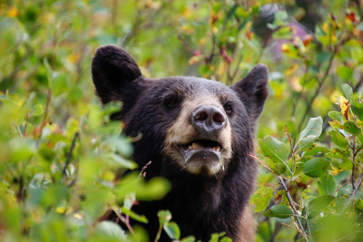
“The decrease in cumulative conflicts in the month of July coincides with the ripening of raspberries, blackberries, and blueberries,” according to Colin Carpenter, black bear project leader with the W.Va. Division of Natural Resources.
As these natural foods become plentiful, bears spend more time feeding deep in forests and less time searching neighborhoods for garbage, bird feeders, livestock feed, or pet food.
“Bear movements are tied to food sources,” Carpenter says. “Bears that roam around residential areas in search of food are less likely to stay if they do not find anything to eat.”
While bears remain opportunistic feeders throughout the summer, abundant wild crops help keep many of them focused on natural forage rather than human-provided food sources.
Read more: Why more West Virginians are seeing black bears this summer
A tradition rooted in Appalachia
Long before grocery stores, midsummer berry season was among Appalachia’s most anticipated harvests.
Native peoples gathered wild berries for food and medicine, and later settlers preserved them as jams and jellies, baked them into pies, and canned them for winter. For many families, berry picking became both a necessity and a cherished summertime tradition.

For Matt Welsch, a West Virginia food historian, chef, and advocate for Appalachian foodways, berry picking remains one of the state’s most enduring seasonal rituals.
“I grew up picking berries on the farm,” Welsch says. “It was a family activity, a communion, and it always ended in a treat, whether that was something simple like fresh berries over cornbread with sugar and milk or a fresh fruit pie.”
Although the fruits now fill supermarket shelves year-round, he says gathering them in the woods offers something modern conveniences cannot replace.
“They say splitting your own wood warms you twice,” Welsch says. “Gathering forest berries is a treat twice over. Berries are in every grocery store these days, but nothing compares to those fresh from the woods. Picking berries is a touchstone for who we really are.”
That tradition remains especially strong in West Virginia’s high country. Grafton noted that “hundreds of people make annual forays to Dolly Sods, Spruce Knob, and nearby areas to pick blueberries,” a seasonal pilgrimage that continues today as hikers combine mountain adventures with one of the state’s most celebrated natural harvests.
Elsewhere, blackberry patches flourish along abandoned farmsteads, old logging roads, utility corridors, reclaimed meadows, and sunny woodland edges, offering some of the easiest and most rewarding wild foods to gather.
Welsch says those outings often became treasured family memories, even if they didn’t always seem that way at the time.
“I don’t want to put on airs,” he says. “I remember a lot of griping when we’d head out to pick berries. But even at my crabbiest, I couldn’t deny what coming home with a full pail meant. The griping was part of it. So was the pie.”
Reading the health of the forest
To wildlife biologists, berry patches reveal much more than where to find summer fruit.
The abundance—or scarcity—of the fruits reflects weather patterns, forest health, and habitat quality. Strong berry years provide ample nutrition for wildlife, helping many species raise young successfully and prepare for the changing seasons. Poor berry crops, caused by late frosts, drought, or other environmental conditions, can force animals to travel farther in search of food.
For black bears especially, the difference can be noticeable. When natural foods are scarce, bears are more likely to investigate neighborhoods and campsites in search of alternative meals. When berry crops are abundant, many remain deep within forests, where food is plentiful.
For Welsch, berry patches also remind people that they share the mountains with countless other creatures.
“My favorite thing to do out there is look for animal signs,” he says. “Tracks and scat show me I’m part of a larger ecosystem, standing in the same patch the bears and the birds are working. It connects me with the land. I treasure that feeling.”
Knowing which berries to pick
Not every colorful berry growing in the woods is safe to eat. Grafton advised that “white or whitish fruits generally should be regarded as toxic and poisonous.”
Plants such as poison ivy, poison sumac, doll’s-eyes, white coralberry, and mistletoe produce berries that should be avoided.
He also warned that the unripe fruits of may-apple and groundcherry are toxic, and that the seeds of cherries and pokeberries contain poisonous compounds. Even experienced foragers harvest only berries they can identify with certainty.
Fortunately, West Virginia’s best-known edible berries—blackberries, raspberries, blueberries, huckleberries, strawberries, and serviceberries—are among the easiest to recognize when ripe.
Why wild berries taste different
Welsch believes wild berries have flavors that cultivated fruit simply cannot duplicate.
“Wild berries had to fight for everything, so the flavor is concentrated,” he says. “A grocery-store blackberry was bred to survive a truck ride. A wild one was bred by the hillside it grew on. More acid, more perfume, less water.”
His favorite preparation remains the simplest. “Cornbread, sugar, milk, berries,” Welsch says. “That’s the one I reach for first because that’s what berries meant on the farm.”

Today, he also enjoys using wild fruit in savory dishes, especially blackberry gastriques and sauces served with locally raised beef.
“A blackberry-based steak sauce is a current favorite,” he says. “Wild blackberries, a splash of vinegar, and a good cut of beef will tell you everything about a West Virginia summer.”
More than a summer harvest
Every berry patch tells a larger story about West Virginia’s forests. It feeds migrating birds before autumn, fuels growing bear cubs through summer, shelters rabbits and nesting songbirds beneath tangled canes, supports pollinators, and sustains a seasonal tradition that has connected generations of West Virginians to the land. It also preserves recipes, family memories, and food traditions that remain deeply rooted in Appalachian culture.
For visitors exploring the state’s back roads and mountain trails this July, the ripening fruits are evidence of a healthy Appalachian landscape where people and wildlife continue to share the same seasonal harvest—a reminder that some of West Virginia’s oldest traditions begin with something as simple as a blackberry by the trail.
West Virginia
West Virginia town fires entire police force after chief resigns, sergeant alleges evidence room break-in

Former Barrackville Police Chief Zachary Freeburn. (Barrackville Police Department Facebook)
A tiny West Virginia town is at the center of a growing controversy after its entire police department was abruptly relieved of duty just days after its police chief resigned, sparking public backlash, allegations of government overreach and growing demands for transparency.
“Effective immediately, the entire Barrackville Police Department has been relieved of duty by the Mayor and City Council,” the department wrote in a Facebook post on Tuesday.
“We are sincerely grateful for the support, trust, and encouragement shown to us by the Barrackville community throughout our service. It has been an honor and a privilege to serve and protect this town.”
DC POLICE OFFICIALS FACE TERMINATION AFTER FEDERAL PROBE UNCOVERS ALLEGED MANIPULATED CRIME DATA BY DEPARTMENT
The announcement stunned residents and marked the apparent collapse of the small department just months after officials celebrated hiring a new chief to rebuild the agency.
In December 2025, the department announced Zachary Freeburn’s appointment as its new full-time chief of police, highlighting his graduation from the West Virginia State Police Academy, his bachelor’s degree in criminal justice and his advanced Drug Recognition Expert certification.
“We look forward to continuing to rebuild and strengthen our department to better serve our community, and we are excited to once again have a full-time officer leading our agency,” the department wrote at the time.
CITY MANAGER ‘BEGGED’ FIRED CINCINNATI POLICE CHIEF FOR MORE OFFICERS ON STREET AS CRIME SKYROCKETED

Former Barrackville Police Chief Zachary Freeburn accepts an award during a West Virginia law enforcement event in 2025. (Barrackville Police Department Facebook)
Less than seven months later, that effort had unraveled.
Last week, the department announced that Freeburn had resigned “effective immediately.” The agency said Sgt. Hunt would serve as officer in charge while assuring residents that police operations would continue.
“Until further notice, Sergeant Hunt will serve as the officer in charge of the Barrackville Police Department to ensure the continued operation of the department,” the department said, adding that questions about the leadership transition could be addressed at the next town council meeting.
NEWARK MAYOR QUESTIONS STATE POLICE TACTICS AT DELANEY HALL AFTER SHERRILL’S ORDER, CALLS AGENCY ‘A SWORD’
Instead, the department itself was relieved of duty days later.
A letter Freeburn wrote before the department was dismissed offers his account of why he stepped down.
The letter, which was shared with WBOY and intended to be read at the July 7 town council meeting before it was canceled, alleges that shortly after the newly elected town council took office, he was called into a closed-door meeting where he was told a council member would directly supervise the police department and implement operational changes.
Freeburn wrote that he objected because he believed those directives violated West Virginia law governing municipal police departments. He said that when he attempted to discuss the proposed changes, he was told, “If I give you a directive you follow it… I am in charge and what I say goes.”
He described the situation as creating what he believed would become a hostile work environment and said those concerns ultimately led him to resign.
In the letter, Freeburn also wrote that one of the biggest complaints he heard from residents was a lack of transparency at town hall. He said he chose to resign so the issues could be brought into the open, expressing hope that residents would finally receive “the transparency that they have been asking for.”
The letter notes it was written before the announcement that the entire police department had been relieved of duty.
Former Barrackville Police Sgt. Hunt, who has been publicly identified only by his last name, told WBOY that he discovered the police evidence room had allegedly been entered when he arrived at the department Tuesday morning.
Hunt alleged town officials had previously discussed conducting an inventory of the department without officers present. He also claimed that during a meeting with Mayor Tom Straight and members of the town council, Councilmember Alex Neville acknowledged taking a set of police keys.
According to Hunt, after he accused town officials of entering the evidence room, he and another officer, who together made up the department’s entire sworn force, were immediately relieved of duty. Hunt also said he informed town officials that he intended to seek whistleblower protections.
Fox News Digital has not independently verified Hunt’s allegations.
The controversy appears to have been brewing even before the department was dismissed.
Following Freeburn’s resignation, a Barrackville resident launched an online petition urging the town council to reinstate him, arguing that he had been “forced to resign due to what many residents believe was unnecessary overreach by the newly elected Town Council.”
The petition calls on town leaders to reconsider the circumstances surrounding the resignation, restore public confidence through transparency and reinstate Freeburn as police chief.
“Our Police Chief quickly earned the trust, respect, and appreciation of our community through his professionalism, leadership, integrity, and commitment to keeping Barrackville safe,” the petition states. “Although his time serving our town was brief, his impact was undeniable.”
Organizers also urged residents to attend the July 7 town council meeting to voice their concerns. The meeting was later canceled.
In a Facebook post, the Barrackville Town Council announced the meeting had been canceled because of “a lack of sufficient information regarding items listed under unfinished business.”
The cancellation has only fueled questions from residents, many of whom flooded social media demanding answers.
“Time to do some deep background on the city council. The truth is not being told,” one commenter wrote beneath the police department’s announcement.
Another resident joked, “Who is gonna look over the 5 residents in Barrackville now?”
Barrackville, a town of about 1,200 people in north-central West Virginia, is located about 25 miles southwest of Morgantown.
Marion County Sheriff Roger Cunningham previously told WBOY that the sheriff’s office will continue responding to calls in Barrackville, as it routinely does throughout Marion County, ensuring residents continue receiving law enforcement services despite the town no longer having an active police department.
Town officials have not publicly explained why the entire department was relieved of dutyor responded to the allegations raised by former officers.
Fox News Digital has reached out to the Barrackville Police Department, Straight, members of the Barrackville Town Council and the Marion County Sheriff’s Office for comment. Fox News Digital has also contacted the West Virginia Municipal League seeking clarification on the authority of municipal officials over police department operations under state law.
Get the latest updates on this story at FOXNews.com
-

 Montana4 minutes ago
8 Most Welcoming Towns In Montana’s Countryside
-

 Nebraska11 minutes ago
Nebraska abortions rose nearly 8% in 2025, mostly due to influx of Iowa patients
-
 Nevada14 minutes ago
Murder suspect from Montana takes own life when surrounded by police in Nevada
-

 New Hampshire19 minutes ago
2 transgender girls drop NH lawsuit after Supreme Court ruling, personal hardships
-

 New Jersey26 minutes ago
NJ Legislators Are Considering a Bill That Could Ban Tesla Robotaxis Due to Their Tech Choice
-

 New Mexico29 minutes ago
New gay bar opens in Nob Hill
-
North Carolina34 minutes ago
Explore on the water: How, where to kayak in Raleigh
-

 North Dakota41 minutes ago
Schulz to transition from ND Parks and Recreation to ND Department of Corrections and Rehabilitation


