Science
Wildfires can release more energy than an atomic bomb. No wonder they look apocalyptic

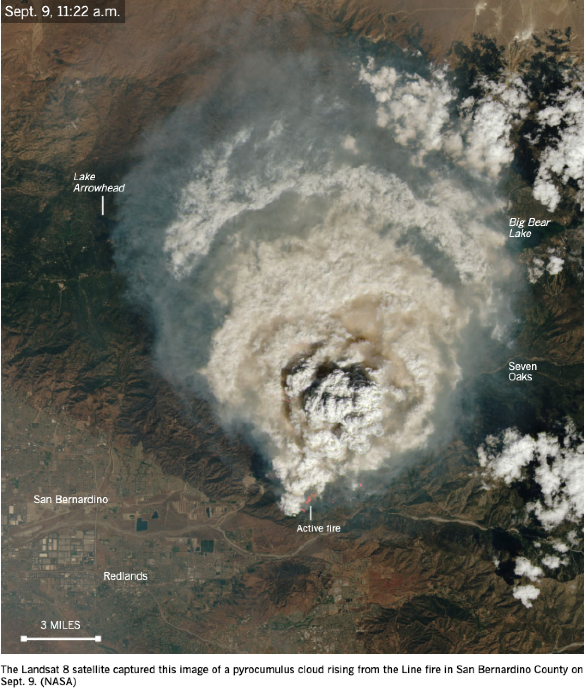
The first full weekend of September, with the Line fire 20,000 acres in size and only 3% contained, a resident of San Bernardino County described the sky as looking “exactly like a nuclear warhead had been set off.”
On a basic level, this makes sense: By that point, the Line fire had already released more energy into the atmosphere than a dozen atomic bombs. And just as nuclear blasts produce a distinctive mushroom cloud, uncontrolled wildfires can be powerful enough to generate their own weather.
When wood and other vegetation combust, it they produce four main compounds: carbon dioxide, smoke (itself a mix of toxic ingredients like carbon monoxide, methane, benzene and many more), heat and water vapor. Of those, carbon dioxide is the least relevant to the local weather — while it plays a major role in the global climate, that is more because of its long lifespan rather than its immediate potency.
The most notable consequence of smoke emission is its dangerous effects for human health.
A plume of smoke can extend hundreds or thousands of miles as it’s carried by wind currents. In addition, smoke aerosols block and scatter sunlight, causing the surreal “red sun” effect that shows up in apocalyptic-seeming pictures on social media; their optical properties also tend to suppress precipitation in downwind locations, which may (in the long term) fuel more fires because of drier conditions.
Billowing smoke from the Line fire, right, and Airport fire, left, obscure the sun and turn the sky an apocalyptic hue of orange.
(Gina Ferazzi/Los Angeles Times)
The next byproduct of fire is heat — like the burner in a hot air balloon, the wildfire causes the bottom layer of the atmosphere to become less dense and therefore rise. As the air over the fire is lifted, air from the outside rushes in to replace it, thereby supplying the fire with the oxygen that allows it to continue burning.
If the fire is powerful enough, it can produce a “firestorm.” This occurs when all the winds surrounding a conflagration are directed toward the fire’s center, leading to a feedback effect: more oxygen produces more intense flames, which in turn pull in even more oxygen.
These winds have a mixed effect on the fire’s ability to spread — on the one hand, the gusts are directed inward, meaning that sparks are less likely to be pushed outward. On the other hand, the strong updrafts can catch hold of burning embers, lofting them into unburned material, where they can produce “spot fires” up to several miles away from the fireline.
Moreover, a firestorm can radiate heat so intense that it becomes impossible for firefighters to operate in its vicinity. Firestorms have been observed not only during wildfires but also during World War II when bombed cities — such as Dresden, Germany, and Hiroshima, Japan, —experienced far more destruction from resultant fires than from the initial bombing.
The final ingredient is water vapor.
As the hot air rises higher in the atmosphere, the water vapor released by combustion will condense, aided by the presence of smoke particles that act as “condensation nuclei” and allow the water to form droplets. This condensation produces more heat, leading to even more powerful convection, and the end result is known as a pyrocumulus (or, in more extreme cases, pyrocumulonimbus) cloud.
These clouds often signal trouble for firefighters trying to contain the blaze — not just because they indicate that the fire is gaining strength, but also because the dangerous conditions and low visibility within the cloud prevent the use of aircraft to fight the fire. In addition, these clouds can produce frequent lightning strikes, which ignite new fires in the area.
One saving grace is that the pyrocumulus clouds can produce rain, which in some cases will suppress the very fire that created them. However, depending on wind conditions, this rain sometimes evaporates before it reaches the ground because of the hot, dry environment surrounding the fire.
If this occurs, it can produce a “downburst” as cold, dense air descends rapidly out of the cloud. Just like the updrafts, this feeds the fire with fresh, oxygenated air; unlike updrafts, downbursts cause gusts that billow out away from the center of the fire, leading it to spread rapidly in multiple directions at once.
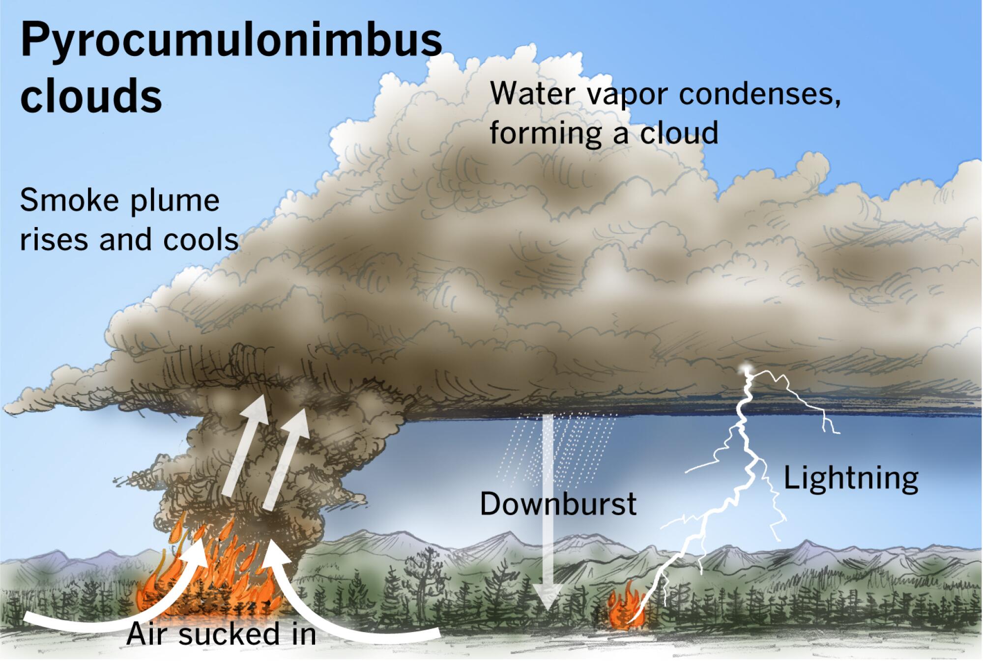
A pyrocumulonimbus is the ultimate extreme pyrocumulus cloud.
(Paul Duginski / Los Angeles Times)
What does all this mean for Southern California?
Fortunately, large-scale firestorms are almost unheard-of in the area, in part because the region’s narrow canyons and strong prevailing winds act to direct gusts — and therefore fires — in specific directions. Less fortunately, both factors can act to speed fire spread and promote pyrocumulus formation.
Structures on the top of hills and ridges are at heightened risk, since fires can move up to eight times faster when they are climbing steep slopes than they do on flat land, and lightning strikes from pyrocumulonimbus clouds are more likely to strike elevated locations.
With the National Interagency Fire Center predicting above normal fire potential along the Southern California coast through the end of the year, there is a strong likelihood that more fires are on the way for the region in the coming months.
The feedback between wildfires and their environment can cause rapid and unpredictable shifts in the fires’ direction and intensity, so it is vital for residents to remain alert during high-risk periods.

new video loaded: NASA Announces Artemis III Crew
transcript
transcript
NASA Announces Artemis III Crew
NASA announced the crew of Artemis III mission, which will fly to low-Earth orbit to test rendezvous and docking maneuvers with one or two lunar landers.
-
“I am excited to welcome you as the next crew in the Artemis journey to successfully return to the moon — this time to stay.” “I’m honored by the role that I’ve been given. I’m also very humbled by the task in front of us. But first and foremost, I’m grateful.” “So with that, the Artemis II crew, comrade, hands you the baton. You got the controls.” “As you know, we had a significant anomaly at our Launch Complex 36A on May 28. We’ve redoubled our efforts and are moving forward.”
By Alisa Shodiyev Kaff
June 9, 2026
Science
Santa Monica Mountains’ last steelhead trout survived the Palisades fire — and even had babies

Scientists feared the Santa Monica Mountains’ last remaining steelhead trout were dead, smothered by debris flows unleashed by the Palisades fire.
But the endangered fish surprised them: A team of biologists recently spotted 30 of the rare trout — and 21 babies — in Topanga Creek.
“There was a lot of happy dancing in the creek,” said Rosi Dagit, principal conservation biologist for the Resource Conservation District of the Santa Monica Mountains, which works with public and private landowners to conserve natural resources.
That’s because the steelhead here are endangered, at both the state and federal levels. Once, they swam in most streams of the Santa Monicas, but their numbers plummeted amid overfishing and coastal development. Increasingly frequent wildfire has further stressed their habitat. Topanga Creek, a biodiversity hot spot, is home to their last known population in the mountains that stretch from the Hollywood Hills to Point Mugu in Ventura County.
The trout that were spotted, including this one, are part of a distinct Southern California population that’s listed as endangered at the state and federal levels.
(RCDSMM Stream Team)
The California Department of Fish and Wildlife spearheaded a complex mission to rescue trout threatened by the Palisades fire that sparked in January 2025.
Time was of the essence. The fire hadn’t yet been fully contained. But rain was on the way, which would sweep massive amounts of sediment from the denuded hillsides into the water. Fish are often killed this way.
Crews stunned the fish with electricity, scooped them up in buckets, trucked them to a hatchery and ultimately moved them to Arroyo Hondo Creek in Santa Barbara County.
Within days, Topanga Creek was choked with mud. Some assumed the fish left behind were goners.
But in March, the conservation district’s team found four. The following month, when water conditions were clearer, they saw more.
“These fish continue to amaze me,” said Kyle Evans, environmental program manager for the state Department of Fish and Wildlife, who had seen the damage to the creek. “I had seen populations get wiped out in similar situations. So when I heard, I was thrilled.”
Evans surmises the fish that survived were in an area of the creek where less charred material and sediment were swept in.
“These fish likely hunkered down, were hiding under some rocks or places to try to get away from the main concentration of flow,” he said. “And luckily they weren’t buried.”
The ones that were spotted were fairly small, around 6 to 14 inches. Rainbow trout and steelhead trout are the same species, but with different lifestyles. If the fish remain in freshwater, they’ll be considered rainbows. However, they can migrate to the ocean and become steelhead, where they typically grow larger before returning to their natal waters to spawn.
Topanga Creek hasn’t fully recovered from the damage it sustained, but scientists say it’s looking better. Surveys last year were “so depressing,” Dagit said, with very few animals, and stretches that were essentially transformed into flat roads from all the sediment buildup. Some of the riparian canopy burned right down to the creek.
Then came 32 inches of rain over the last nine months, scouring out and moving sediment, creating deeper pools. Dagit said they recently found newt egg masses for the first time in years, as well as a few adult newts and many frogs. Plants that provide cover are starting to recover.
She provided photos comparing certain pools last year and this year, some dramatically transformed. In September 2025, the Shrine Pool could have been an overgrown hiking trail. This April, it was filled with shallow water.

The Shrine Pool in September 2025, left, and the same location in April 2026, right, with RCDSMM’s Isaac Yelchin donning a wetsuit.
(RCDSMM Stream Team)
Topanga Creek is home to another endangered fish, the small but hardy northern tidewater goby, often described as cute. Not long before the trout operation, Dagit led a rescue of hundreds of these fish too. Many were repatriated to the lagoon at the mouth of the creek in a moving ceremony last June.
There’s still the matter of what to do with the trout that were moved to Santa Barbara County last year. Evans would like to bring them home to the Santa Monicas at some point, but isn’t sure if it will happen. On one hand, they could bolster the small, genetically isolated surviving population. On the other, they might inadvertently bring in a disease or bacteria. There is some time to decide. Evans estimates the creek still needs to recover for two to three more years.
For now, the fish are functioning fine in their adopted creek. Experts worried the trauma wrought by the move would disrupt their spawning process, but they had babies that spring. This year, they spawned again.

The Pacifica Municipal Pier was shut down and taped off Thursday after city workers noticed cracks running through the landmark structure and concrete chunks falling into the ocean.
It’s just one of many coastal California structures that have recently crumbled under pressure from a rising and relentless ocean.
Officials from the small, beach city south of San Francisco said the pier was closed due to “cracking, separation, and displacement of the concrete walkway and structural elements.”
It will stay closed while structural engineers asses its safety.
Photos taken by city employees show a wide crack that runs from top to bottom and across the structure as well. Other photos show a large horizontal crack under the foundation of a small restaurant on the pier, the Chit Chat Cafe.
The cafe was also shut down.
This is not the first time the 53-year-old pier has shown signs of stress. In 2021, part of it was shut down after handrails along the edge collapsed. And in 2023, after a series of storms pummeled the Central California coast, damaging parts of the pier, the structure was partially closed for more than year.
Those same storms caused extensive damage in Aptos and Capitola, 70 miles south, where piers and waterfront infrastructure were swept away or damaged.
In 2024, a 150- to 180- foot section of the Santa Cruz wharf was ripped off by powerful waves.
At least 10 of the state’s dozens of coastal public piers were closed for part or all of 2024 due to structural damage sustained in winter storms since 2022. At least five others have longer-term upgrades planned to address structural issues.
“These things are costly to maintain,” said Zach Plopper, senior environmental director at Surfrider. “They are a part of our California coastal culture in many ways, but we’re going to need to reckon with, one, the state that they’re in, and two, the continuous and worsening threats they’re going to experience,”
He said most of the piers were constructed in the early 1900s, and they weren’t built to withstand decades of rough seas, storms and rising sea level.
“With this incoming El Niño, which is forecasted to be significant, and this marine heat wave we’re in the midst of, we’re kind of in uncharted waters as far as what this winter could bring in terms of storms and swells to the California coast, and we’re likely going to see a lot more damage,” he said. “Not just piers, but roads and other coastal infrastructure up and down the state.”
There was no storm in Pacifica earlier this week, so no single event could be blamed for the destruction.
However, a 2025 report from an outside engineering firm, GHD, found that several sections of the pier were in “poor” or “serious” condition, and they recommended closure before anticipated storms or events that could “subject the piles to high winds, swells and large waves.”
The firm found several areas of the pier where concrete was missing and rebar was exposed and corroding.
“The pier has continued to experience high winds and large waves in a harsh marine environment,” the engineers wrote in the report, noting that continuous exposure to seawater or marine spray was “detrimental” to the structure.
A 2023 city report estimated it would cost $19 million to repair.
That same year, a state law was enacted to require local governments along the California coast to plan for sea level rise in the coming decades.
Sea level has risen some 8 inches, on average, along the coast in the past 150 years, Plopper said, and researchers anticipate another foot in the next 25 years.
“We’re going to see profound shifts on our coastline, none that we have ever experienced before, and building static structures on the coast just doesn’t work all that well,” he said. “We’re going to have to make some really hard decisions.”
-

 Kentucky4 minutes ago
What states spend the most on fast food? Kentucky ranks among the top
-

 Louisiana11 minutes ago
Winnsboro woman dies in single-vehicle crash on LA Highway 867
-

 Maine14 minutes ago
Live updates: Midterms take shape in California, Maine, S.C. and Nevada; Trump to sign ICE bill
-

 Maryland19 minutes ago
Alert Days Wednesday through Friday for severe weather risk, intense heat in Maryland
-

 Michigan26 minutes ago
Trieu: For Michigan State targets, visits, in-state decisions loom
-

 Massachusetts29 minutes ago
Make Father’s Day memorable with these 10 activities in Massachusetts
-

 Minnesota34 minutes ago
Strong winds, downed trees hit Twin Cities, cutting power to 50,000 in Minnesota
-

 Missouri39 minutes ago
New West Boulevard Elementary School principal announced

