Colorado
Strong winter storm impacting southern Colorado today

Today’s Forecast:
Our well-advertised winter storm impacts us today in southern Colorado. Rain and snow showers are ongoing along the I-25 corridor, southern mountains, and eastern plains. Several lightning strikes were detected overnight on the eastern plains due to instability in place with this potent system.
Various winter weather alerts are in effect:
Snow totals will depend on elevation, with the rain/snow line hovering around 6,000 feet today. It will drop down a bit this evening, so any remaining rain/snow after 8:00PM will have a better chance of falling as snow at elevations as low as 5,000 feet.
Very solid Gulf of Mexico and Pacific moisture, combined with a rapidly strengthening surface low to our southeast producing good upslope, will combine to produce heavy rain and snow rates. When we get these heavy precipitation rates, our air cools – so despite marginal temperatures, expect more snow than rain today, particularly above 6,000 feet in elevation. While snow will continue all day, I expect two rounds of heavier snow. The first will be this morning into early afternoon as very strong upslope flow combines with a bit of instability (thunderstorm energy) to produce strong snow rates. Snow continues through the afternoon, and may again be heavy at times mid-afternoon and the evening as the low begins to move away. As it does so, our airflow will “stretch out” a bit, and this stretching gives the air a bit of energy to produce banding snow. There’s a bit of a question as to whether this energy stays along the I-25 corridor or moves west – which will affect our snow timeline. I’m leaning it sticking west of I-25, but east of the mountains for now, which keeps snow in our forecast through the evening.
Snow showers will become more sporadic tonight, with a few lingering into tomorrow morning before the entire system rolls away by afternoon and sunshine returns.
Colorado Springs forecast: High: 38; Low: 25.
Rain and snow. Snow generally above 6,000 feet – west of I-25, with rain east toward the airport and Fountain. Patchy fog will also roll through the area. Snow totals will vary by elevation with the highest totals in Briargate, Rockrimmon, and other higher elevation portions of the Springs. Snow will generally end around 10PM tonight, with remnant showers possible through Sunday morning.
Pueblo forecast: High: 43; Low: 27.
Rain for the most part due to warmer temperatures from your lower elevation relative to other regions. Rain will be heavy at times. It’ll also be breezy with a north wind increasing in the afternoon to 10-25 mph. Overall, a fairly dreary day but you won’t need the shovels! Tonight, you’ll cool down. Remnant moisture could fall as snow, so in a high end scenario you could get an inch of snow from this storm.
Canon City forecast: High: 41; Low: 29.
Rain and snow mix, with snow whenever the precipitation is falling more heavily. Snow gets heavier late this afternoon before ending around 11PM/12AM – with remnant showers still possible until early Sunday. Your best chance for accumulations come tonight.
Woodland Park forecast: High: 32; Low: 18.
WINTER STORM WARNING in effect until Sunday at 5:00AM.
Snow. Heavy – both in rate, and type…very water heavy and spring-like. Good for making snowballs, heavy to shovel. Continuous snow ends by 11PM with hit-or-miss snow showers continuing into early Saturday.
Tri-Lakes forecast: High: 29-32; Low: 20s.
WINTER STORM WARNING in effect until Sunday at 5:00AM.
Plains forecast: High: 40s; Low: 30s.
Snow. Heavy at times with 1-2″/hr rates possible. Snow gets lighter during the mid-afternoon, with parts of the area potentially seeing an end to snow. However, snow generally should continue into the evening.
Walsenburg and Trinidad forecast: High: 36; Low: 23.
WINTER STORM WARNING in effect until Sunday at 5:00AM.
Snow, heavy at times, with a rumble or two of thunder possible. Snow will become more hit or miss tonight.
Mountains forecast: High: 30s; Low: 20s.
WINTER STORM WARNING in effect until Sunday at 5:00AM.
Heavy snow with high accumulations. Northeast winds at 10-15 mph. Patchy blowing snow tonight.
Extended outlook forecast:
Highs return to the 50s Monday with a period of relatively calm weather before we bring in more clouds Tuesday as a system moves into the mountains. Our next chance for unsettled weather looks to be late next week, as our next upper level trough approaches.
____
Curious about the First Alert 5 Weather Storm Impact Scale? Check out our cheatsheet explainer.
Watch KOAA News5 on your time, anytime with our free streaming app available for your Roku, FireTV, AppleTV and Android TV. Just search KOAA News5, download and start watching.


")
")


DENVER — Five of the seven law enforcement officers in a rural Colorado county, including the sheriff, have been indicted in an investigation into allegations of misconduct, prosecutors said Friday.
A grand jury indicted Costilla County Sheriff Danny Sanchez and former Deputy Keith Schultz on charges of allegedly mishandling human remains discovered in October 2024, according to court documents. A man who found the remains and reported them to the sheriff’s office said Sanchez and Schultz took only the skull and left the other remains behind, including teeth, court documents state.
Two months passed before Schultz wrote a report, saying he left bones in a bag on his desk and went on another call, the documents state. A coroner’s official said he received the skull in an unlabeled paper bag from the sheriff’s office, the documents state.
Separately, Undersheriff Cruz Soto, Sgt. Caleb Sanchez — the sheriff’s son — and Deputy Roland Riley are charged in connection with the use of a Taser against a man who was suffering a mental health crisis in February and tried to leave when they insisted he go to the hospital, according to the documents. The man said he was “roughed up” by deputies and was left with broken ribs, according to the indictments.
Soto was charged with failing to intervene and third-degree assault, according to court documents. Caleb Sanchez and Riley were charged with second- and third-degree assault.
In announcing the indictments, 12th District Attorney Anne Kelly said she’s committed to investigating and prosecuting crimes no matter the offender.
“I cannot and will not ignore violations of the trust that a community should have in their police. No citizen of the San Luis Valley should have any doubts about the integrity of their police force,” Kelly said at a news conference Friday evening.
A person who answered the phone Friday at the sheriff’s office said it had no immediate comment but planned to post a statement online. Phone numbers listed for Danny Sanchez, Soto and Riley did not work. Caleb Sanchez did not have a listed number. An unidentified person who answered a number for Schultz referred The Associated Press to an attorney, Peter Comar. The AP left a message Friday for Comar seeking comment.
__

As a result of a snow drought and a heat wave that have both set records, some Colorado residents face the earliest restrictions on their water use ever imposed.
Denver Water announced Wednesday that it is seeking a 20% cut in water use, asking people to turn off automatic watering systems until mid-May and restricting the watering of trees and shrubs to twice a week.
“The situation is quite serious,” said Todd Hartman, a spokesperson for the utility. “We’re in such a dire situation that we could be coming back to the public in two or three months and saying you’re limited to one day a week.”
It is the earliest in the year that Denver Water has ever issued a restriction, Hartman said.
Colorado’s snowpack peaked at extremely low levels on March 12 — nearly a month earlier than usual — then cratered during the recent heat wave that cooked nearly every state in the West.
“We already had the lowest snowpack we’ve seen since at least 1981, and now, with the heat wave conditions, we’ve already lost about 40% of the statewide snowpack” since the March 12 peak, said Peter Goble, Colorado’s assistant state climatologist. “Conditions are looking more like late April or early May.”
The water restrictions are a harbinger of what’s to come in many Western states as officials try to manage widespread drought concerns. Nearly every snow basin in the Mountain West had one of its warmest winters on record and is well behind normal when it comes to water supply, according to the U.S. drought monitor. The dwindling snowpack is likely to raise the risk of severe wildfires, hamper electricity generation at hydropower dams and force water restrictions for farmers.
Hartman said nearly every community east of the Rockies, along Colorado’s front range, is in much the same boat as Denver.
City Council members in Aurora are considering similar water restrictions; reservoirs there stand at about 58%, according to the city’s website. In the town of Erie, officials declared a water shortage emergency on March 20 after they observed a massive spike in consumption.
Gabi Rae, a spokesperson for the town, said Erie was perilously close to having taps run dry because so many residents had started watering their lawns early amid the unseasonable heat.
“We were a day away from running out of water. That’s why it was such an emergency,” she said.
Erie officials demanded that residents stop using irrigation systems altogether.
Goble said this month’s heat wave has set records in every corner of Colorado, sometimes by double digits.
“I can’t remember seeing a single heat wave that broke this many records, and seeing it across such a large portion of the country is certainly eye-popping,” he said, adding: “I’m located in Fort Collins, and we got up to 91 last Saturday. The previous record for March was 81, so we smashed that record. And it wasn’t just one day, either.”
Denver Water, which serves about 1.5 million residents in the city and its surrounding suburbs, gets about half of its water from the Upper Colorado River Basin and the South Platte River Basin. The latter’s snowpack was at about 42% of normal Tuesday, the utility reported. The Upper Colorado River Watershed was at 55%.
Systemwide, Denver Water’s reservoirs are about 80% full, which is only about 5 percentage points lower than in a typical year.
“That sounds pretty good,” Hartman said. “Except that what we’re not going to be able to rely on is that rush of water that will bring those reservoirs back up, because the snowpack is so low.”
In other words, the snowpack — a natural water reservoir — is mostly tapped already and won’t replenish reservoirs later this spring and into summer, when runoff usually peaks.
In Erie, city workers plan to aggressively police water use until sometime next week using smart meters that monitor residential usage. Rae said the city is also sending utility workers to patrol neighborhoods and look for sprinklers that are turned on.
“People have been kind of annoyed with how aggressive we were, and I don’t necessarily think they understand the ramifications if we weren’t,” Rae said. “It is an actual serious emergency situation. We were so close to reaching empty, there would literally be no water coming out of the taps — hospitals, schools, fire hydrants, your home would have no water.”
Although the limits on outdoor watering will be lifted soon, Rae expects more restrictions later this spring and summer.
Colorado
Suddenly hazy skies in Denver prompt some residents concerned about wildfire smoke to call 911

Some people who live in the Denver metro area on Thursday afternoon were making calls to 911 after skies became noticeably hazy and winds kicked up. It was due to smoke from wildfires in Nebraska moving into Colorado. A cold front also was moving through the Front Range, and there is dust in the air.
The poor air conditions led to reduced visibility downtown after 3 p.m. Several of CBS Colorado’s City Cams showed dust or smoke in the air.
Temperatures were expected to drop by as much as 20 to 30 degrees with the cold front.
The suddenly dusty skies prompted at least one fire agency to put out a plea to residents to please only call 911 “if you see flames.” That warning was put out by South Metro Fire Rescue, which shared a photo on X of an office building with haze visible outside.
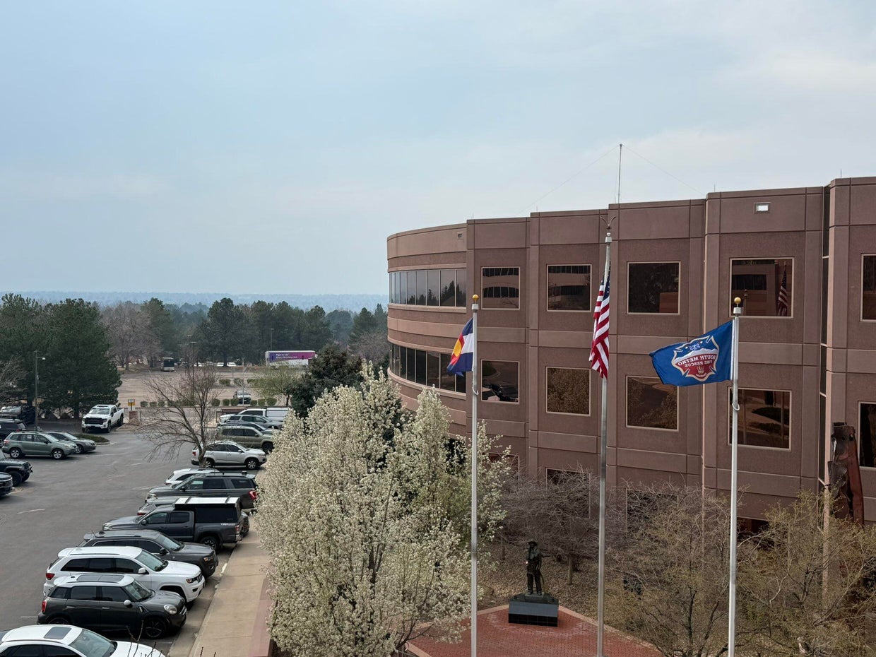
South Metro Fire Rescue said in their post that the smoke is from Colorado’s neighbor to the east. They called it a “significant haze” in the air.
Earlier this month, the Morrill Fire and the Cottonwood Fire burned a significant amount of Nebraska grassland and ranchland. They have mostly been contained by firefighters. Nebraska Gov. Jim Pillen said those two fires combined with several others have burned approximately 800,000 acres of land. On Thursday, Pillen announced that he is signing several executive actions intended to ease the burden caused by the fires.
There were no wildfires burning in the Denver metro area on Thursday afternoon.

Springlike heat surges across Utah; only isolated showers
VT Lottery Mega Millions, Gimme 5 results for March 27, 2026

How to watch TCU vs. Virginia women’s Sweet 16: Time, TV, stream

In deep-red Washington County, a surge in Democratic candidates

In battleground Wisconsin, the 2026 elections are poised to bring a ‘changing of the guard’

Florida High School Football Rankings: Top 25 teams – Oct. 21

How old is Bo Nix? What to know about Oregon quarterback ahead of 2024 NFL Draft

Cleary's 21 help Le Moyne down Central Connecticut State 69-64 in OT

99th annual Pony Swim held in Virginia

Indiana Members Credit Union announced as new anchor tenant at Bottleworks District

Dem senators dodge crucial question on illegal alien accused of killing Chicago college student

EU Parliament unblocks key political hurdle in digital euro talks

Man arrested in plot to firebomb Palestinian activist’s home after undercover op

WATCH: Senate hearing goes silent after Angel Father confronts top Dem over daughter’s death

US diplomat Marco Rubio denounces settler violence, tolls in Hormuz strait
-

 Detroit, MI1 week ago
Drummer Brian Pastoria, longtime Detroit music advocate, dies at 68
-

 Movie Reviews1 week ago
‘Youth’ Twitter review: Ken Karunaas impresses audiences; Suraj Venjaramoodu adds charm; music wins praise | – The Times of India
-

 Sports7 days ago
IOC addresses execution of 19-year-old Iranian wrestler Saleh Mohammadi
-

 New Mexico5 days ago
Clovis shooting leaves one dead, four injured
-
 Business1 week ago
Disney’s new CEO says his focus is on storytelling and creativity
-

 Tennessee5 days ago
Tennessee Police Investigating Alleged Assault Involving ‘Reacher’ Star Alan Ritchson
-

 Technology6 days ago
YouTube job scam text: How to spot it fast
-

 Texas1 week ago
How to buy Houston vs. Texas A&M 2026 March Madness tickets