California
Millions of Californians live near oil and gas wells that are in the path of wildfires

As firefighters continue to battle more than two dozen active wildfires in California, new research has found that millions of people are living in close proximity to oil and gas wells that are in the potential path of flames.
More than 100,000 wells in 19 states west of the Mississippi River are in areas that have burned in recent decades and face a high risk of burning in the future, with the vast majority in California, according to a study published recently in the journal One Earth.
What’s more, nearly 3 million Americans live within 3,200 feet of those wells, putting them at heightened risk of explosions, air and water pollution, infrastructure damage and other hazards.
“One of the things that surprised me was just the extent of how many oil wells had been in wildfire burn areas in the past, and how much this was impacting people in California — and is likely to in the coming century,” said David J.X. González, the study’s lead author and an assistant professor of environmental health sciences at UC Berkeley.
Aggressive and impactful reporting on climate change, the environment, health and science.
California is particularly vulnerable to the threat. Of the roughly 118,000 western oil wells in high fire risk areas, 103,878 of them — more than 87% — are in California, with 2.6 million residents living in close proximity to them, according to the study, which was described as the first to investigate historic and projected wildfire threats to oil and gas infrastructure in the United States.
The researchers examined active and inactive oil wells because some inactive wells continue to leak methane and other harmful or combustible emissions, González said. In California, the danger is particularly high in Los Angeles, Fresno, Kern and Orange counties, which are high fire risk areas that are also home to large populations and numerous wells.
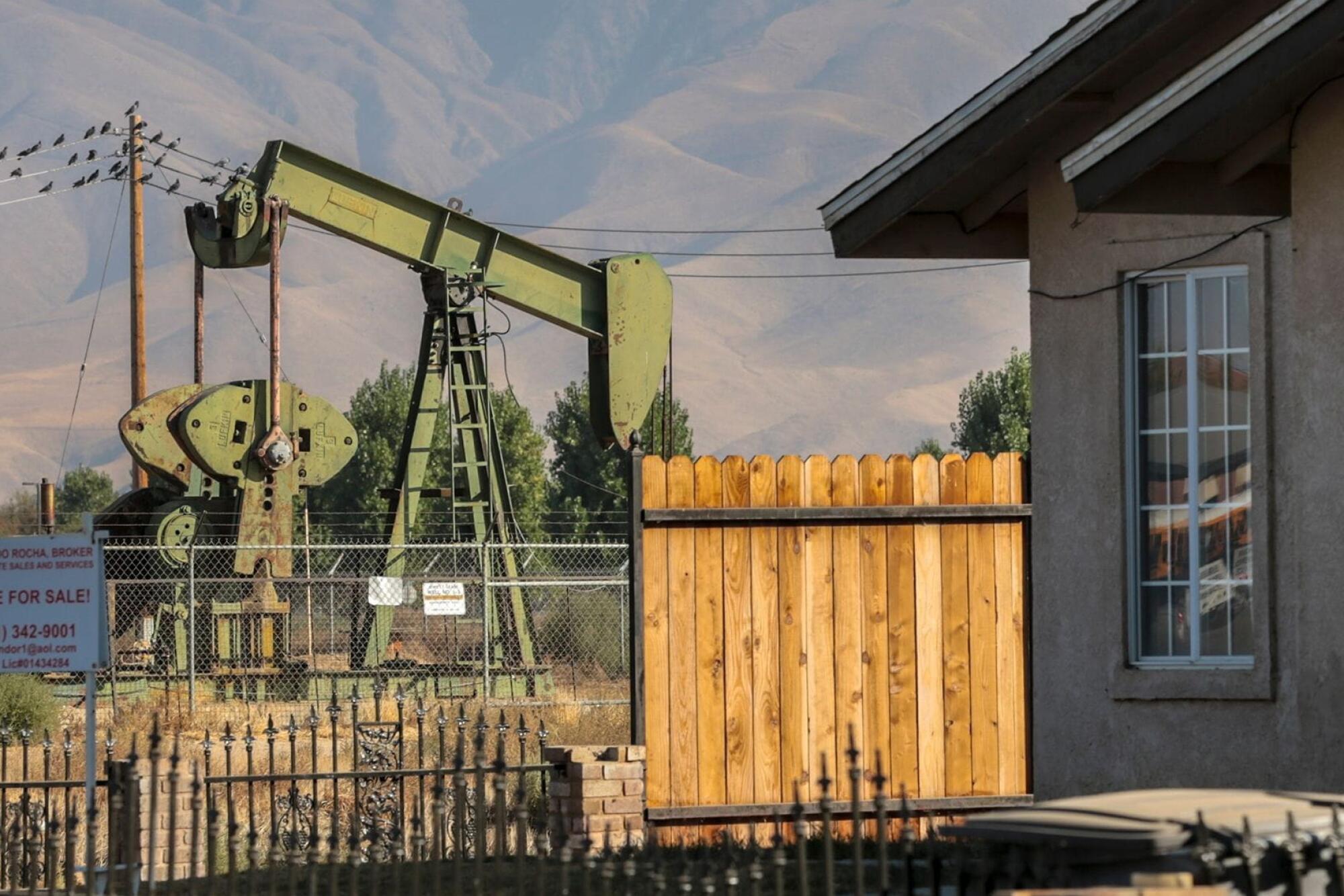
A pump station sits idle near homes in Arvin, Calif., where toxic fumes from a nearby well made residents sick and forced evacuations in November 2019.
(Robert Gauthier / Los Angeles Times)
Many Angelenos have already experienced the perils of living near oil and gas infrastructure. In 1985, methane linked to a long-abandoned oil field fed an explosion at a Ross Dress for Less store in Fairfax, injuring more than 20 people.
In 2015, a massive gas leak from the Aliso Canyon underground storage facility near Porter Ranch released about 100,000 tons of methane, ethane and other chemicals into the air, forcing more than 8,000 families to flee their homes and prompting reports of nausea, skin rashes, nosebleeds and other health issues.
Four years later, a 90-year-old well erupted beneath a construction site in Marina del Rey and spewed oil, gas and other debris into the air for several days.
And in 2017, the Thomas fire burned through areas of Santa Barbara and Ventura counties that contained more than 2,100 oil and gas wells — the long-term effects of which have yet to be studied.
It’s not only California that is at risk however. Texas, Oklahoma and New Mexico also host wells in high fire risk areas, the study says. The U.S., in general, has been the top global producer of crude oil and natural gas since 2014, with the majority of production concentrated in the West.
Additionally, oil drilling continues across the country, despite federal and state efforts to curb new wells and cap old ones. One of the provisions included in President Biden’s landmark climate bill, the Inflation Reduction Act, allows for new oil leases to be auctioned on federally managed lands, which means California and other states could see more new wells in the future.
But the California Department of Geologic Energy Management, which oversees oil and gas wells in the state, said production here has been steadily declining since its peak in 1985.
“Presently, CalGEM approves far more permitting applications from operators to plug oil wells than it does to drill new wells,” agency spokeswoman Janice Mackey said in an email. She noted that over the last 12 months, the state agency approved 5,059 permits to permanently plug oil and gas wells while approving only 56 new drills.
Mackey said most of the nearly 250,000 wells under the state agency’s jurisdiction are in the San Joaquin Valley, “but there are also many others in high fire threat areas such as Santa Barbara, Ventura, and Los Angeles counties.”
That could prove to be a problem as wildfire activity continues to worsen, even in the face of slowing oil production. One recent study found that wildfire burn areas in California could increase 50% or more by midcentury, due largely to climate change. Eighteen of the state’s 20 largest wildfires have occurred since 2000.
Additionally, Mackey said the placement of new wells — which are determined by oil and gas operators who seek permits from local governments — has little to do with fire risk.
“California’s oil fields are well established from decades to [over a] century old,” she said. “Operators continue to drill in areas where oil and gas is known to exist.”
Estimates included in the study indicate the hazards will get worse in the decades ahead as population and wildfire activity expand. Between 1984 and 2019, the researchers documented a five-fold increase in the number of wells located in wildfire burn areas, and a doubling of the population living within 3,200 feet of those wells.
By midcentury, more than 122,000 wells are expected to be in high wildfire risk areas, and by late century that number will grow to more than 205,000, according to the study. Both projections are significantly higher when also accounting for moderate wildfire risk areas, and both show that California will continue to experience the lion’s share.
“Wildfires are increasingly burning in oil fields over the past four decades, and it’s a trend that’s very likely to continue throughout the rest of the century, including near some densely populated parts of California,” González said.
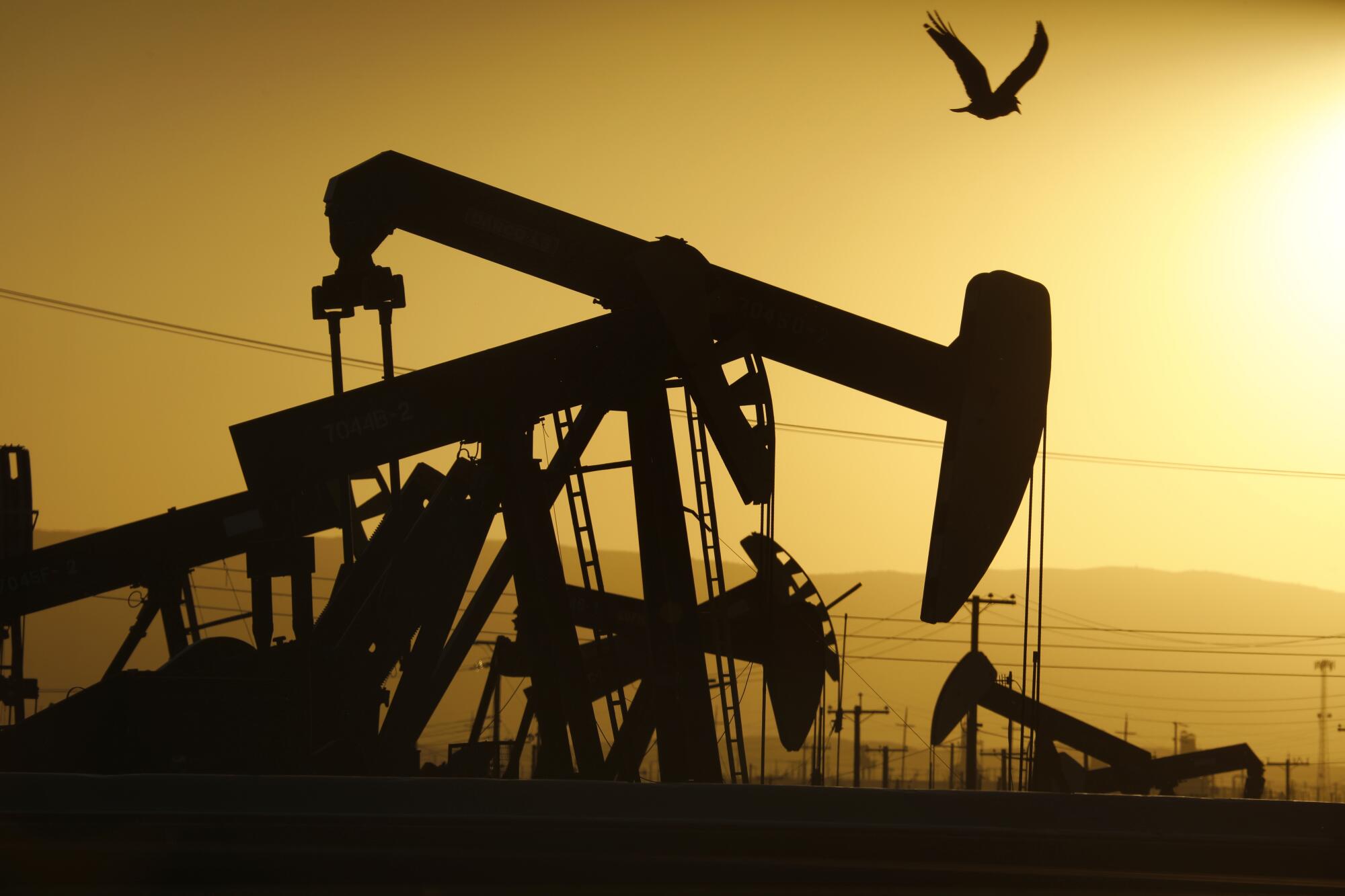
A 2020 photo shows one of more than 1,100 producing oil wells in the McKittrick oil field, just north of McKittrick, Calif., on State Route 33.
(Carolyn Cole/Los Angeles Times)
He added that estimates for the number of wells and people in harm’s way are likely conservative, as the study assessed wells drilled before 2020. That same year was California’s worst wildfire year on record, and saw more than 4.3 million acres burn.
The researchers also found that exposure to oil wells in the path of wildfires was unevenly distributed. Black, Latino and Native American people faced disproportionate risk.
The reasons for this are myriad, according to González.
For one, an estimated 350,000 new houses are constructed each year in the wildland urban interface, or the area where human development meets forestland and other natural landscapes. Such areas often draw people seeking lower costs of living, but face significant wildfire risks because of their remoteness and high vegetation content.
In urban areas, research has found that oil wells are more likely to be sited in neighborhoods that were historically redlined, or racially segregated. New wells are also disproportionately drilled in areas where Black and Latino people live.
There are solutions, however — or at least recommendations to help mitigate the risks of oil wells in populated, wildfire-prone regions. California recently approved legislation that prohibits new oil and gas wells within 3,200 feet of homes, schools, healthcare facilities and other sensitive sites.
The state will also receive more than $35 million in federal funding to help plug and remediate more than 200 high-risk orphaned oil and gas wells, and plans to invest more than a quarter of a billion state and federal dollars into orphan well plugging in the coming years.
The researchers also recommended limiting or eliminating drilling in high wildfire risk areas, and investing in better technology for monitoring wells for leaks of flammable gases.
“There’s a strong base of evidence that active wells are harmful for people that live nearby — even in the absence of wildfires,” González said. “So I think from a public health perspective, additional protections are well justified.”
Mackey, of the California Department of Geologic Energy Management, said oil and gas operators in the state are subject to multiple layers of regulation, including requirements that well pads and tanks be kept free of vegetation, and that wells within specified distances of homes and public rights-of-way have fire prevention devices, sensors and alarm systems.
“In the event of a fire, CalGEM will contact affected field operators to warn them of the possible risk and discuss strategies to prevent damage to wells and equipment,” she said. “Operators are directed to close pipelines and tanks and shut off power to wells if they are not already doing so. Operators also have fire suppression capabilities they deploy during emergencies.”
During the Thomas fire, which was the largest in California at the time, the operators in Santa Barbara and Ventura counties shut down their wells, pipelines and rig work as part of their emergency response to mitigate the risk of fire-related incidents, she said.
Despite such efforts, the study also highlighted what it referred to as a “pernicious feedback loop.” The production and consumption of fossil fuels are driving global warming, which is in turn increasing the frequency and intensity of wildfires, it says. Greenhouse gases emitted by fires are also exacerbating climate change and contributing to the cycle.
González said he hopes the study will prompt more action to not only reduce wildfires, but also to better protect people living in or near the oil wells in their paths.
“We have an opportunity now to take action to prevent future disasters,” he said.


SAN FRANCISCO — The man accused of trying to kill OpenAI CEO Sam Altman by throwing a Molotov cocktail at his San Francisco home is set to make an initial court appearance Tuesday.
Daniel Moreno-Gama, of Spring, Texas, traveled to San Francisco last week and hurled the incendiary device at Altman’s home Friday, setting an exterior gate on fire before fleeing on foot, authorities said. Less than an hour later, Moreno-Gama went to OpenAI’s headquarters about 3 miles (5 kilometers) away and threatened to burn down the building, they said.
No one was injured at Altman’s home or the company’s offices.
Authorities said Moreno-Gama, 20, expressed hatred of artificial intelligence in his writings, describing it as a danger to humanity and warning of “impending extinction,” according to court filings.
“This was not spontaneous. This was planned, targeted and extremely serious,” FBI San Francisco Acting Special Agent in Charge Matt Cobo said during a news conference Monday.
Moreno-Gama is charged in California state court with two counts of attempted murder and attempted arson, San Francisco District Attorney Brooke Jenkins said. He tried to kill both Altman and a security guard at Altman’s residence, she alleged. Officials have not said whether Altman was home at the time.
Online state court records do not yet show whether Moreno-Gama has an attorney who can speak on his behalf.
Craig Missakian, U.S. Attorney, Northern District of California, middle, speaks during a news conference Monday, April 13, 2026, in San Francisco. Credit: AP/Jeff Chiu
Jenkins said the state charges carry penalties ranging from 19 years to life in prison.
On Monday morning, FBI agents went to Moreno-Gama’s home in a Houston suburb where they spent several hours before leaving. He has also been charged by federal prosecutors with possession of an unregistered firearm and damage and destruction of property by means of explosives. Those charges carry respective penalties of up to 10 years and 20 years in prison.
“We will treat this as an act of domestic terrorism, and together with our partners, prosecute him to the fullest extent of the law,” U.S. Attorney Craig Missakian said when announcing the federal charges Monday.
The federal court documents do not list an attorney for Moreno-Gama, and he has not yet had his first appearance in federal court.
The document in which Moreno-Gama discussed his opposition to AI also made threats against Altman and executives at other AI companies, officials said.
“If I am going to advocate for others to kill and commit crimes, then I must lead by example and show that I am fully sincere in my message,” Moreno-Gama wrote, according to authorities.
Advocacy groups that have issued grave warnings about AI’s risks to society condemned the violence.
Anthony Aguirre, president and CEO of the Future of Life Institute, said in a written statement Friday that “violence and intimidation of any kind have no place in the conversation about the future of AI.”
Another group, PauseAI, said in a statement that the suspect had no role in the group but joined its forum on the social media platform Discord about two years ago and posted about 34 messages there, none containing explicit calls to violence but one that was flagged as “ambiguous.”
Discord said Monday that it has banned Moreno-Gama for “off-platform behavior.”

Dad charged with incest after allegedly assaulting daughter
Makayla Rene Settles moved to California to chase her dreams. Two days later, her family says her biological father sexually assaulted her. She was 18. She died five months later. Now her family is fighting to make sure her accused attacker faces trial.
VENTURA COUNTY, Calif. – When Makayla Rene Settles turned 18, she left Raleigh, North Carolina, for a fresh start. She moved to Moorpark, California, to live with her biological father, Stephen Vincent Chavez, with plans to attend college and build a new life. Two days after she arrived, her family says she called terrified and asking for help.
“It was just the fear in her voice, her crying. I didn’t need details. I knew something was wrong, and I said, ‘I’m on the way,’” said Carolina Sandoval, Makayla’s mother.
Carolina says she rushed to Chavez’s home. When she saw her daughter, she was devastated.
“She’s barely walking,” Carolina said. “My brother picks her up and hugs her.”
Makayla was taken to a hospital, where a rape kit was performed. According to the family, the results came back positive for Stephen Vincent Chavez’s DNA. He was arrested that same night and charged with incest, taking advantage of a position of trust, and providing alcohol to a minor.
Her cousin, Crystal Sandoval, was in disbelief. She said, “I was screaming, I was crying. I just kept thinking, why would he do that to her? This is something she could not come back from.”
Crystal was right. Five months later, Makayla Rene Settles died by suicide.
“If I’m being honest, it feels like I handed my daughter to the devil,” said Carolina.
On the night Makayla was taken to the hospital, Sandoval says Chavez sent her a text message. It read, “I’m never drinking liquor again. I don’t want that blackout to happen again.”
Now, the family says they’ve been dealt another devastating blow. According to Crystal Sandoval, the Ventura County DA’s Office has told them the case may not go to trial because Makayla is no longer alive to testify.
“The DA was essentially saying, ‘We don’t know if we have a case because she’s no longer here,’ and when she told me that, I immediately said, ‘No, we’re not going to let that slide,’” said Crystal.
Determined to get justice, Crystal took to social media. Her videos went viral, drawing widespread outrage and prompting hundreds to promise to show up to Chavez’s next court hearing, scheduled for April 21 at the Ventura County Courthouse.
“It was like he took her sunshine away and just kind of broke her soul,” Crystal said.
The Ventura County District Attorney’s Office issued the following statement:
“We have seen the posts online and want to let the public know that our Sexual Assault Unit continues to prosecute the defendant for this extremely serious crime. This case has been filed since July 2025, when the evidence supported the filing of felony charges. As with any case, prosecutors filed charges based on the evidence. The court sets bail. Our office successfully moved to increase bail to $250K in July 2025 when the case was filed. The defendant requested that bail be reduced, but we successfully argued against that. The defendant has since posted $250K bail and is out of custody. With respect to the upcoming hearing, the April 21 date is an early disposition conference. This is a standard pretrial proceeding where the court and parties address the status of the case and set future dates as appropriate.”
Despite that statement, the family says they have already been told a trial is not guaranteed, and they are not backing down. Chavez has pleaded not guilty. His next court hearing is April 21 at 8:30 a.m. in Courtroom 14 at the Ventura County Courthouse.
California
California’s leading GOP candidate for governor reacts to Swalwell’s exit from race | CNN Politics

California’s leading GOP candidate for governor reacts to Swalwell’s exit from race
Republican Gov. candidate Steve Hilton joins CNN’s Dana Bash after one of his opponents, Rep. Eric Swalwell, exited the California governor’s race amid sexual misconduct allegations. “We desperately need change. And no Democrat can provide that,” Hilton says.

Obituary for David Okayama Johnson at Dial-Murray Funeral Home

South Dakota Sports Hall of Fame to induct 21 new members in September

Into the ‘Black Hole:’ Tenn. lawmakers push 240+ bills through the Finance Subcommittee before session ends

Painted Tree Boutiques abruptly closes all locations nationwide, including final Texas stores

Utah County Republican Party to hold convention Saturday

Florida High School Football Rankings: Top 25 teams – Oct. 21

How old is Bo Nix? What to know about Oregon quarterback ahead of 2024 NFL Draft

Cleary's 21 help Le Moyne down Central Connecticut State 69-64 in OT

99th annual Pony Swim held in Virginia

Indiana Members Credit Union announced as new anchor tenant at Bottleworks District

Dem fundraising giant in the hot seat as GOP lawmakers demand answers over dodged subpoena

Fifth woman accuses former US lawmaker Eric Swalwell of sexual misconduct

Commercial Ships Transit Strait of Hormuz as U.S. Blockades Iran’s Ports

Video: How Stephen Miller Is Adjusting Trump’s Immigration Agenda

Biden DOJ weaponized FACE Act against pro-life Americans, 882-report alleges
-

 Atlanta, GA1 week ago
1 teenage girl killed, another injured in shooting at Piedmont Park, police say
-

 Georgia1 week ago
Georgia House Special Runoff Election 2026 Live Results
-

 Arkansas4 days ago
Arkansas TV meteorologist Melinda Mayo retires after nearly four decades on air
-

 Pennsylvania1 week ago
Parents charged after toddler injured by wolf at Pennsylvania zoo
-
 Milwaukee, WI1 week ago
Potawatomi Casino Hotel evacuated after fire breaks out in rooftop HVAC system
-

 Ohio12 hours ago
‘Little Rascals’ star Bug Hall arrested in Ohio
-

 Austin, TX7 days ago
ABC Kite Fest Returns to Austin for Annual Celebration – Austin Today
-

 World1 week ago
Zelenskyy warns US-Iran war could divert critical aid from Ukraine