Alaska
Nine Orcas Have Died In Alaska This Year By Getting Tangled In Fishing Nets

At least nine orcas have died after getting trapped in commercial fishing equipment off the coast of Alaska in 2023 so far. This figure is already significantly higher than many previous years combined, raising speculation that the increase in fatalities could be the result of a “new behavior” within the species.
NOAA Fisheries released a statement explaining that they’ve received 10 separate reports on orcas becoming trapped in fishing boats around Aleutian Island and the Bering Sea this year. One of those individuals managed to escape alive, but the remaining nine died.
It is estimated that there are around 50,000 killer whales globally, around 2,500 of which dwell in the eastern North Pacific Ocean around this part of Alaska.
Incidents like this have happened in the past, but they are rare. A previous NOAA report found that just five orcas had died in the Bering Sea and Aleutian Islands fisheries of Alaska as a result of bycatch between 2016 and 2020.
These statistics have been affirmed by anecdotal reports among fishermen who say that encounters with orcas are becoming increasingly more common in Alaskan waters.
A number of vessels involved in the recent encounters have been associated with the Groundfish Forum, a Seattle-based fishery trade association. Some of their sailors have reported orcas approaching their ships more often and using it as an opportunity to hunt fish. This, they claim, seems to be part of a new behavior.
“Our fishermen believe that the killer whales are attracted to fishing gear because fishing activities aggregate fish and allow killer whales to feed on the catch. In 2023, our captains have reported an increase in the number of killer whales present near our vessels, where they appear to be feeding in front of the nets while fishing,” Groundfish Forum said in a statement given to Anchorage Daily News.
“This new behavior has not been previously documented and marine mammal scientists are not sure why this change has occurred,” it added.
Others have suggested that the mounting number of orca fatalities could be the result of a new initiative to reduce halibut bycatch by sorting the nets on deck and returning halibut to the sea. However, Groundfish Forum denied this was a factor, saying: “These assertions are not true because our vessels do not conduct deck sorting when killer whales are present.”
This isn’t the only potential new behavior seen among orcas. On the other side of the world along the south coast of Spain, there have been numerous reports of orcas intentionally smashing into the bottoms of vessels and aggressively following them back to port. In May 2023 alone, at least 18 incidents like this were reported.
Once again, marine mammal experts have been stumped as to where this behavior emerged from, although some sailors suspect that commercial fishing might be a factor.
“I am not a scientist, but orcas have a migration pattern and there are huge tuna fishing nets at Barbate, I do wonder whether they associate vessels with fishing and taking their tuna,” sailor April Boyes wrote in a blog post.

Alaska
Sky Watch Alaska: planets align plus the aurora forecast

ANCHORAGE, Alaska (KTUU) – This is a great time of year to do some star gazing. If you have clear skies in your part of Alaska, take the time to check out the night — and morning — sky.
After sunset, look toward the southwest. Saturn and Venus are snuggled up together (of course, they are more than 800 million miles apart) in the evening sky. They set at about 9:40 p.m. in Southcentral.
Before 9:40 p.m., you can see four planets with the naked eye — Saturn, Venus, Jupiter and Mars. Jupiter and Mars stick around through the morning. Mars is very close to the moon right now.
The Aurora forecast is fairly weak for the next few weeks. That’s not to say there won’t be the occasional burst but overall, solar activity is expected to be fairly low until the beginning of February.
If you get great pictures of the planets, the sky, or the aurora, don’t forget to send them to Alaska’s News Source.
See a spelling or grammar error? Report it to web@ktuu.com
Copyright 2025 KTUU. All rights reserved.
Alaska
Short-lived cold snap, with another warming trend this weekend

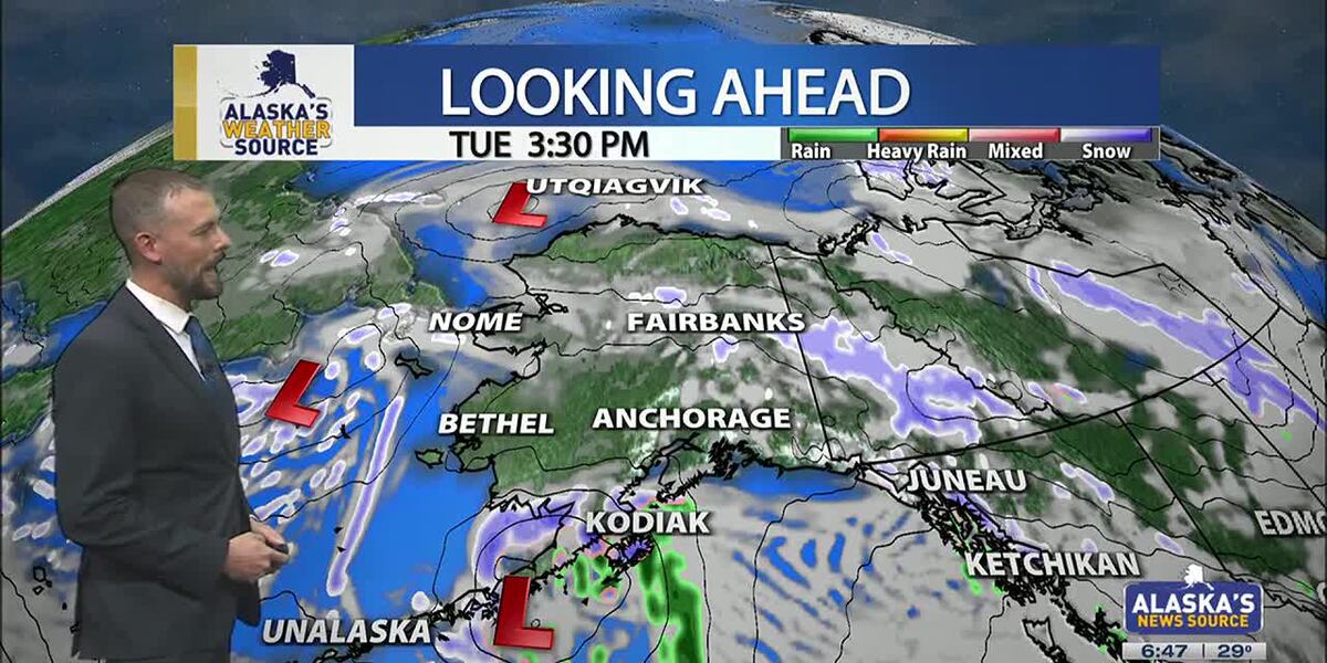
ANCHORAGE, Alaska (KTUU) – Temperatures across the state are cooling off, as our strong low from the weekend moves into the Chukchi Sea. This will set up for colder air to spread across the state this week, as another short-lived cold snap is expected. While some light snow is possible for the Interior, areas of the Slope and Western Alaska, Southcentral will stay on the drier side until the night. Meanwhile, Southeast will continue to hold onto moderate rain with gusty conditions.
SOUTHCENTRAL:
Temperatures this morning are 10 to 20 degrees colder than yesterday, as colder air has settled back into Southcentral. Clear skies and calm winds are evident this morning for parts of the region, with light snow falling through the Copper River Basin. We’ll see fairly quiet conditions today, outside of Kodiak which will see increasing snow and rain into the afternoon and evening hours. This comes as our next area of low pressure moves up the Alaska Peninsula.
We’ll see light snow spreading north across the Kenai overnight into Wednesday, with light snow expected through Prince William Sound. Several inches are likely through the Kenai and Chugach Mountains, with the pass expected to see a couple of inches of accumulation. Western parts of the Kenai will see the potential for a few inches, while inland areas of Southcentral largely stay dry. If Anchorage and surrounding locations see any accumulation, it’ll amount to less than half an inch.
As snow tapers off Wednesday, we’ll see the return to colder and drier conditions into Thursday. Thursday may be the coldest day this week across the region, before another warming trend carries us into next week. Right now holding with snow through early next week, but areas of wintry mix are possible as highs warm above freezing.
SOUTHEAST:
The winter storm warning for Skagway and higher elevations expired at 6am this morning. While some light snow showers are still possible, little accumulation will occur the rest of the day. Scattered to periodic showers are occurring elsewhere across Southeast today, with less than half an inch of rainfall through the day. Any moisture available into the evening will see a transition to some wintry mix or snow into Wednesday morning. However, the better chance will come from another low lifting north into the panhandle. Any snow and wintry mix we see for Wednesday will primarily stay confined to the central and southern panhandle. We’ll see much cooler weather taking hold this week for Southeast.
INTERIOR:
Some areas of light snow are possible this morning, with less than half an inch to be expected. While temperatures are still warm for much of the Interior, highs will steadily fall throughout the day. Many areas will see lows bottom out near or below zero by tomorrow morning. We’ll see high pressure keep things dry and sunny through the next couple of days, with the coldest stretch of weather from Wednesday morning into Thursday morning. Much like the rest of the state will experience, a warming trend arrives this weekend. We’ll see the return to highs in the 20s, with some snow in the forecast. Be prepared for some gusty conditions through the Alaska Range by the close of this week.
SLOPE/WESTERN ALASKA:
Areas of light snow and blowing winds will continue to impact the Slope, with a winter weather advisory remaining in place for the Central Brooks Range and the Beaufort Sea Coast. Both locations will see up to 1 inch of snow and gusty winds up to 35 mph. While the winter weather advisory will expire for the Central Brooks Range this afternoon, the Beaufort Sea Coast will see the alert continue into Tuesday evening. Snow and blowing snow will be the primary impact today, with a return to colder weather through the rest of this week, this comes as high pressure settles into the area.
The storm responsible for the damaging winds for Southcentral over the weekend, has pushed north into the Chukchi Sea. We’ll still see some light snow accumulations for Western Alaska, with 1 to 3 inches expected. Some fo the heaviest snow will fall across the Seward Peninsula and the Western Brooks Range.
An area of low pressure in the Bering Sea will keep gusty winds and snow in the forecast for Gambell/St. Lawrence. Be prepared for heavy snow at times and areas of reduced visibility. Overall, colder weather will settle into Western Alaska, with the possibility of morning fog in the valleys over the next few mornings.
ALEUTIANS:
Some light areas of snow will occur for the Pribilof Islands and into parts of the Alaska Peninsula today, as a weak low moves up the Peninsula. This will be the main focus for snow into Wednesday for Southcentral. This low will bring heavy precipitation and gusty winds for the Eastern Aleutians and the Alaska Peninsula. Looking ahead through the rest of the week, we can expect to see more a ridge beginning to build into the region. This ridge will slowly shift east, keeping several upper level disturbances traversing the Aleutians. Temperatures will remain fairly warm in the 30s and 40s.
OUTLOOK AHEAD:
Model consensus continues to agree on another warming trend heading our way into next week. This stretch of warmth will likely lead to many spots cementing themselves within the top warmest January’s on record. While we’ll spend the rest of this week on the colder side, highs steadily climb this weekend into next week. We’ll see highs in Southcentral climbing back above freezing, with areas of the Interior climbing back into the 20s.
Have a safe and wonderful Tuesday!
See a spelling or grammar error? Report it to web@ktuu.com
Copyright 2025 KTUU. All rights reserved.
Alaska
Anchorage, Alaska hit by hurricane-force winds, structures damaged across city

Associated Press
Hurricane-force winds cause widespread damage in Alaska’s largest city
Thousands of residents across Alaska’s largest city were still without power Monday, a day after a powerful storm brought hurricane-force winds that downed power lines, damaged trees, forced more than a dozen planes to divert, and caused a pedestrian bridge over a highway to partially collapse. A 132-mph (212-kph) wind gust was recorded at a mountain weather station south of Anchorage. A large low-pressure system in the Bering Sea brought the high winds, moisture and warmer than average temperatures — in the low 40s Fahrenheit (slightly over 4.4 degrees Celsius) — to Anchorage on Sunday, said National Weather Service meteorologist Tracen Knopp.
-

 Health1 week ago
Ozempic ‘microdosing’ is the new weight-loss trend: Should you try it?
-
/cdn.vox-cdn.com/uploads/chorus_asset/file/25822586/STK169_ZUCKERBERG_MAGA_STKS491_CVIRGINIA_A.jpg)
 Technology6 days ago
Technology6 days agoMeta is highlighting a splintering global approach to online speech
-

 Science3 days ago
Metro will offer free rides in L.A. through Sunday due to fires
-
/cdn.vox-cdn.com/uploads/chorus_asset/file/25821992/videoframe_720397.png)
 Technology7 days ago
Technology7 days agoLas Vegas police release ChatGPT logs from the suspect in the Cybertruck explosion
-

 Movie Reviews1 week ago
‘How to Make Millions Before Grandma Dies’ Review: Thai Oscar Entry Is a Disarmingly Sentimental Tear-Jerker
-

 Health1 week ago
Michael J. Fox honored with Presidential Medal of Freedom for Parkinson’s research efforts
-

 Movie Reviews1 week ago
Movie Review: Millennials try to buy-in or opt-out of the “American Meltdown”
-

 News7 days ago
Photos: Pacific Palisades Wildfire Engulfs Homes in an L.A. Neighborhood
/cdn.vox-cdn.com/uploads/chorus_asset/file/23382327/VRG_Illo_STK022_K_Radtke_Musk_Twitter_Upside_Down.jpg)


