Science
Faster alerts for California megaquakes: Early-warning system gets major upgrade

California’s earthquake early-warning system is getting a seismic upgrade, one that will allow residents to receive more timely alerts about shaking from an incoming megaquake.
The upgrade, also available in Oregon and Washington, will provide features important for warnings about the “Big One.”
The improvements could mean that, depending on where they are and where the quake begins, Californians would receive an earlier, more accurate estimate of magnitude before the earth starts shaking — say from a magnitude 7.8 earthquake that begins on the San Andreas fault near the Mexican border and ruptures the fault toward Los Angeles County.
The upgrade also would improve warnings for the Pacific Northwest and California’s North Coast, which are threatened by tsunamis from quakes along the Cascadia subduction zone.
The U.S. Geological Survey and its nonprofit partner EarthScope announced the upgraded system Wednesday.
For the most powerful earthquakes, the improvements “become very, very critical in helping us get to the answer quicker — in terms of how big that event is,” said Robert de Groot, one of the operations team leaders of the USGS’ ShakeAlert System.
For smaller earthquakes, the older system worked “perfectly fine,” De Groot said. But with larger quakes, the magnitude could be underestimated for quite some time, robbing residents of crucial information in the seconds before they feel the most destructive shaking.
Let’s say an earthquake on the southern San Andreas fault that starts near the Mexican border ends up being a magnitude 8, but the earliest estimate says it’s a magnitude 6.5. The longer that underestimate is broadcasting to phones, the less likely people are to take appropriate action.
“People would react differently — much differently — than if you said it was a magnitude 8,” said David Mencin, vice president of data services for EarthScope, a nonprofit funded by the National Science Foundation, USGS and NASA that’s supplying data for the improved early-warning system.
“The largest, most destructive earthquakes are the ones that we’re really worried about,” Mencin said. “This fixes the problem of underestimating those magnitudes, which is critical.”
One of the most famous underestimations came in 2011 with the epic magnitude 9.1 earthquake that triggered a devastating tsunami off the eastern coast of Japan, leaving roughly 18,000 dead. An initial estimate put the quake’s magnitude at 7.9, meaning the actual earthquake was an astonishing 63 times stronger in terms of energy released.
That underestimation led to a misjudgment of tsunami heights — with some of the first detailed alerts erroneously estimating the tsunami would be lower than protective sea walls. And when communications were cut off, a false sense of security settled in, with many people never receiving accurate evacuation alerts.
Had Japan used GPS data, a more accurate magnitude of the quake could’ve been generated far more quickly, Mencin said.
The USGS’ West Coast earthquake early-warning system has long relied on hundreds of seismic sensors embedded in the ground. But there is only so much shaking they can detect in a short time.
“Seismometers tend to get overwhelmed for earthquakes that are magnitude 7 and greater. They can begin to get ‘saturated,’” Mencin said. During particularly intense shaking, the seismometers — basically objects on a spring — start to hit the wall of the instrument, and so the seismic signal is “clipped” and can’t quickly calculate magnitudes above a certain threshold.
Coming to the rescue now are hundreds of GPS sensors on Earth’s surface and run by EarthScope. Most of the time, these sensors track very slow movement, on the order of millimeters or less per year. That can illustrate subtle tectonic plate action between major earthquakes, illustrating how the Pacific plate, where L.A. is located, is nudging northwest relative to the North American plate, where the Mojave Desert is located.
But in a major earthquake, there is considerable, permanent movement of the ground, where one piece of land jolts away from the other, moving yards in seconds. In the great San Francisco earthquake of 1906, land on one side of the San Andreas fault generally jammed 8.5 feet past the other, De Groot said.
And in the last great southern San Andreas earthquake — rupturing the fault in 1857 between Monterey and San Bernardino counties — land on one side of the fault generally lurched 10 feet relative to the other side. Both the 1857 and 1906 earthquakes were somewhere around magnitude 7.8.
In the largest of the Ridgecrest earthquakes in 2019, there were about 2 feet of fault offset for the magnitude 7.1 quake, De Groot said.
The first calculation of the earthquake early-warning system will still rely on seismic sensors, which measure ground velocity and acceleration, De Groot said. Then, as a quake continues to rupture along a fault, GPS sensors will measure the distance a block of land has moved.
“What GPS allows us to do is to get a handle on how big that earthquake is getting — or could be — sooner,” De Groot said. That means the early-warning system could realize a quake was a magnitude 7, or higher, a few seconds earlier than before.
It’s important to know that an earthquake’s magnitude doesn’t appear instantly. Quakes rupture on a fault at the speed of sound through rock, which is slower than the light speed of today’s telecommunications systems. This is the principle that allows people farther away from the start of an earthquake to get seconds of advance warning of the worst shaking to come.
On the San Andreas fault, an earthquake that begins rupturing at the Salton Sea and ends at Mt. San Gorgonio, roughly 80 miles away, would produce a magnitude 7.3 earthquake.
A rupture of the San Andreas fault between the Salton Sea and Mt. San Gorgonio could produce a magnitude 7.3 quake.
(Angelica Quintero / Los Angeles Times)
But one that ruptures the entire 340-mile length of the southern San Andreas, ending in Monterey County, would create a magnitude 8.2 earthquake and produce shaking over a much wider swath of Southern and Central California.
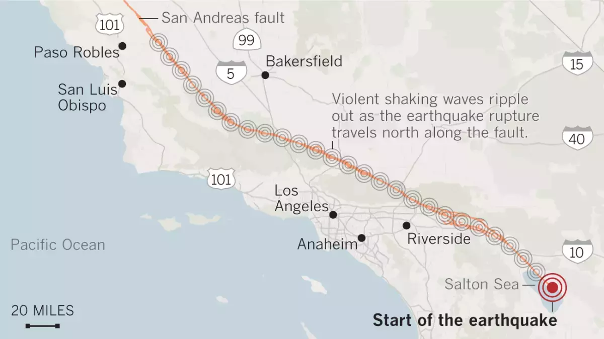
A rupture of the entire 340-mile length of the southern San Andreas fault between Monterey County and the Salton Sea would produce a magnitude 8.2 earthquake.
(Angelica Quintero / Los Angeles Times)
“As the earthquake grows in size, it’ll be able to help update that magnitude more quickly and with more accuracy,” De Groot said of the GPS data, which will spread the early warnings to a larger region. “By adding in the [GPS] data, you actually get a handle on how big the earthquake really is sooner.”
The net result will “translate into longer warning times for people who could potentially get alerts on their phones,” De Groot said. That would give people more time to take action, such as surgeons and dentists moving sharp tools from near patients, allowing trains to slow to reduce the risk of derailment, opening firehouse doors before they can be jammed shut and giving the public time to drop, cover and hold on.
Depending on where people are, some may not get a warning before they feel the first shaking, which is known as the “P wave.” But the goal is to give a warning before the most damaging shaking occurs — the “S wave” — which comes later.
“What we really want to get people to know about is getting the alert before the strongest shaking,” De Groot said.
By the end of 2025, the USGS’ ShakeAlert — which is about 90% complete — is expected to have 1,675 seismic sensing stations. EarthScope says an additional 1,000 GPS stations run by the nonprofit are contributing data to the system.
EarthScope, the nation’s primary seismological and geodetic data facility, was recently formed as the merger of UNAVCO, which held an archive for GPS data, and IRIS, which held a seismic data archive.
The earthquake early-warning system has become more popular in recent years as people get more accustomed to the alerts. In February’s widely felt magnitude-4.6 earthquake in Malibu, some felt left out when they didn’t receive an early warning.
The alerts can be received by downloading the free MyShake app on iOS and Android. Android users are automatically subscribed to Android Earthquake Alerts. Those systems are set to sound an alarm when an earthquake is estimated to be of magnitude 4.5 or higher and the expected shaking intensity at the user’s cellphone location is expected to be at least “weak” — level 3 on the Modified Mercalli Intensity Scale, where it’s felt quite noticeably by people indoors and may rock standing motor vehicles slightly or feel like a truck is passing by.
Earthquakes of greater strength — magnitude 5 and above — will send users a wireless emergency alert, similar to an Amber Alert, if they’re in a location expected to get at least “light” shaking intensity. That’s level 4 on the Modified Mercalli Intensity Scale — shaking intensity enough to rattle dishes, windows and doors, and can feel like a heavy truck striking a building.

new video loaded: NASA Announces Artemis III Crew
transcript
transcript
NASA Announces Artemis III Crew
NASA announced the crew of Artemis III mission, which will fly to low-Earth orbit to test rendezvous and docking maneuvers with one or two lunar landers.
-
“I am excited to welcome you as the next crew in the Artemis journey to successfully return to the moon — this time to stay.” “I’m honored by the role that I’ve been given. I’m also very humbled by the task in front of us. But first and foremost, I’m grateful.” “So with that, the Artemis II crew, comrade, hands you the baton. You got the controls.” “As you know, we had a significant anomaly at our Launch Complex 36A on May 28. We’ve redoubled our efforts and are moving forward.”
By Alisa Shodiyev Kaff
June 9, 2026
Science
Santa Monica Mountains’ last steelhead trout survived the Palisades fire — and even had babies

Scientists feared the Santa Monica Mountains’ last remaining steelhead trout were dead, smothered by debris flows unleashed by the Palisades fire.
But the endangered fish surprised them: A team of biologists recently spotted 30 of the rare trout — and 21 babies — in Topanga Creek.
“There was a lot of happy dancing in the creek,” said Rosi Dagit, principal conservation biologist for the Resource Conservation District of the Santa Monica Mountains, which works with public and private landowners to conserve natural resources.
That’s because the steelhead here are endangered, at both the state and federal levels. Once, they swam in most streams of the Santa Monicas, but their numbers plummeted amid overfishing and coastal development. Increasingly frequent wildfire has further stressed their habitat. Topanga Creek, a biodiversity hot spot, is home to their last known population in the mountains that stretch from the Hollywood Hills to Point Mugu in Ventura County.
The trout that were spotted, including this one, are part of a distinct Southern California population that’s listed as endangered at the state and federal levels.
(RCDSMM Stream Team)
The California Department of Fish and Wildlife spearheaded a complex mission to rescue trout threatened by the Palisades fire that sparked in January 2025.
Time was of the essence. The fire hadn’t yet been fully contained. But rain was on the way, which would sweep massive amounts of sediment from the denuded hillsides into the water. Fish are often killed this way.
Crews stunned the fish with electricity, scooped them up in buckets, trucked them to a hatchery and ultimately moved them to Arroyo Hondo Creek in Santa Barbara County.
Within days, Topanga Creek was choked with mud. Some assumed the fish left behind were goners.
But in March, the conservation district’s team found four. The following month, when water conditions were clearer, they saw more.
“These fish continue to amaze me,” said Kyle Evans, environmental program manager for the state Department of Fish and Wildlife, who had seen the damage to the creek. “I had seen populations get wiped out in similar situations. So when I heard, I was thrilled.”
Evans surmises the fish that survived were in an area of the creek where less charred material and sediment were swept in.
“These fish likely hunkered down, were hiding under some rocks or places to try to get away from the main concentration of flow,” he said. “And luckily they weren’t buried.”
The ones that were spotted were fairly small, around 6 to 14 inches. Rainbow trout and steelhead trout are the same species, but with different lifestyles. If the fish remain in freshwater, they’ll be considered rainbows. However, they can migrate to the ocean and become steelhead, where they typically grow larger before returning to their natal waters to spawn.
Topanga Creek hasn’t fully recovered from the damage it sustained, but scientists say it’s looking better. Surveys last year were “so depressing,” Dagit said, with very few animals, and stretches that were essentially transformed into flat roads from all the sediment buildup. Some of the riparian canopy burned right down to the creek.
Then came 32 inches of rain over the last nine months, scouring out and moving sediment, creating deeper pools. Dagit said they recently found newt egg masses for the first time in years, as well as a few adult newts and many frogs. Plants that provide cover are starting to recover.
She provided photos comparing certain pools last year and this year, some dramatically transformed. In September 2025, the Shrine Pool could have been an overgrown hiking trail. This April, it was filled with shallow water.

The Shrine Pool in September 2025, left, and the same location in April 2026, right, with RCDSMM’s Isaac Yelchin donning a wetsuit.
(RCDSMM Stream Team)
Topanga Creek is home to another endangered fish, the small but hardy northern tidewater goby, often described as cute. Not long before the trout operation, Dagit led a rescue of hundreds of these fish too. Many were repatriated to the lagoon at the mouth of the creek in a moving ceremony last June.
There’s still the matter of what to do with the trout that were moved to Santa Barbara County last year. Evans would like to bring them home to the Santa Monicas at some point, but isn’t sure if it will happen. On one hand, they could bolster the small, genetically isolated surviving population. On the other, they might inadvertently bring in a disease or bacteria. There is some time to decide. Evans estimates the creek still needs to recover for two to three more years.
For now, the fish are functioning fine in their adopted creek. Experts worried the trauma wrought by the move would disrupt their spawning process, but they had babies that spring. This year, they spawned again.

The Pacifica Municipal Pier was shut down and taped off Thursday after city workers noticed cracks running through the landmark structure and concrete chunks falling into the ocean.
It’s just one of many coastal California structures that have recently crumbled under pressure from a rising and relentless ocean.
Officials from the small, beach city south of San Francisco said the pier was closed due to “cracking, separation, and displacement of the concrete walkway and structural elements.”
It will stay closed while structural engineers asses its safety.
Photos taken by city employees show a wide crack that runs from top to bottom and across the structure as well. Other photos show a large horizontal crack under the foundation of a small restaurant on the pier, the Chit Chat Cafe.
The cafe was also shut down.
This is not the first time the 53-year-old pier has shown signs of stress. In 2021, part of it was shut down after handrails along the edge collapsed. And in 2023, after a series of storms pummeled the Central California coast, damaging parts of the pier, the structure was partially closed for more than year.
Those same storms caused extensive damage in Aptos and Capitola, 70 miles south, where piers and waterfront infrastructure were swept away or damaged.
In 2024, a 150- to 180- foot section of the Santa Cruz wharf was ripped off by powerful waves.
At least 10 of the state’s dozens of coastal public piers were closed for part or all of 2024 due to structural damage sustained in winter storms since 2022. At least five others have longer-term upgrades planned to address structural issues.
“These things are costly to maintain,” said Zach Plopper, senior environmental director at Surfrider. “They are a part of our California coastal culture in many ways, but we’re going to need to reckon with, one, the state that they’re in, and two, the continuous and worsening threats they’re going to experience,”
He said most of the piers were constructed in the early 1900s, and they weren’t built to withstand decades of rough seas, storms and rising sea level.
“With this incoming El Niño, which is forecasted to be significant, and this marine heat wave we’re in the midst of, we’re kind of in uncharted waters as far as what this winter could bring in terms of storms and swells to the California coast, and we’re likely going to see a lot more damage,” he said. “Not just piers, but roads and other coastal infrastructure up and down the state.”
There was no storm in Pacifica earlier this week, so no single event could be blamed for the destruction.
However, a 2025 report from an outside engineering firm, GHD, found that several sections of the pier were in “poor” or “serious” condition, and they recommended closure before anticipated storms or events that could “subject the piles to high winds, swells and large waves.”
The firm found several areas of the pier where concrete was missing and rebar was exposed and corroding.
“The pier has continued to experience high winds and large waves in a harsh marine environment,” the engineers wrote in the report, noting that continuous exposure to seawater or marine spray was “detrimental” to the structure.
A 2023 city report estimated it would cost $19 million to repair.
That same year, a state law was enacted to require local governments along the California coast to plan for sea level rise in the coming decades.
Sea level has risen some 8 inches, on average, along the coast in the past 150 years, Plopper said, and researchers anticipate another foot in the next 25 years.
“We’re going to see profound shifts on our coastline, none that we have ever experienced before, and building static structures on the coast just doesn’t work all that well,” he said. “We’re going to have to make some really hard decisions.”
-

 Utah2 minutes ago
New NBA Draft Intel: AJ Dybantsa, Darryn Peterson and Utah
-

 Vermont9 minutes ago
Vermont Green FC plays Canada’s national soccer team in World Cup tuneup – VTDigger
-

 Virginia12 minutes ago
Navy sailor sentenced to 44 years for killing fellow service member Angelina Resendiz in his Virginia barracks room
-

 Washington17 minutes ago
Where to watch Washington Nationals vs San Francisco Giants: TV channel, start time, streaming for June 10
-

 Wisconsin24 minutes ago
Chris Borland heads back to Wisconsin as Hall of Fame inductee
-

 West Virginia27 minutes ago
West Virginia Democrats re-elect Mike Pushkin, elect new leadership team – The Real WV
-

 Wyoming32 minutes ago
Wyoming’s Most Treasured Views: Grand Teton National Park
-

 Crypto39 minutes ago
‘De-Worsified, Not Diversified’: Robert Kiyosaki Warns Investors on a Hidden Risk

