Iranians react after a ceasefire announcement at the Enqelab square, in Tehran, on April 8 2026.
STR/AFP via Getty Images
hide caption
toggle caption
STR/AFP via Getty Images
The U.S. and Iran reached a ceasefire deal on Tuesday, less than two hours before the deadline President Trump imposed for Iran to meet his demands or else face wide-scale destruction.
As part of the agreement, set to take effect immediately, Trump said the U.S. and Israel would suspend bombing Iran for two weeks, subject to Iran following through on its commitment to reopen the Strait of Hormuz for safe passage during the ceasefire period, a strategic waterway through which about 20% of the world’s oil supplies passes.
Oil prices plunged and stocks surged at the announcement of a pause in fighting, with Brent crude oil dropping to $94.74, or by over 13 %.
In the early hours of the ceasefire, Israel disputed that the deal included a pause of its attacks on Iran-backed Hezbollah in Lebanon.
The negotiations — facilitated by Pakistan — mark a breathtaking comedown from Trump’s pledge made early Tuesday that a “whole civilization will die tonight, never to be brought back again” if a deal could not be reached by 8 p.m. ET to open the strait.
In announcing the deal, Trump wrote on his social media platform: “This will be a double sided CEASEFIRE! The reason for doing so is that we have already met and exceeded all Military objectives, and are very far along with a definitive Agreement concerning Longterm PEACE with Iran, and PEACE in the Middle East.”
Trump added that Iran has proposed a “workable” 10-point peace plan that includes what he described as “points of past contention,” which “have been agreed to between the United States and Iran.” The extra time, he said, will allow the agreement to be finalized.
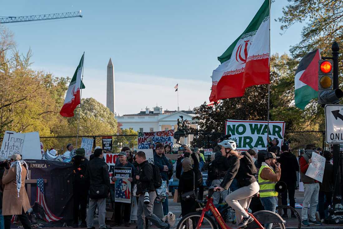
Protesters in opposition to the war with Iran gather outside of Lafayette Park across from the White House on April 7, 2026 in Washington, DC.
Andrew Leyden/Getty Images North America
hide caption
toggle caption
Andrew Leyden/Getty Images North America
Iran’s plan, as published by the Iranian Mehr news agency, consists of a set of conditions that Iran claims the U.S. administration has accepted. They include Iran’s control over the Strait of Hormuz, acceptance of its nuclear enrichment, the withdrawal of all U.S. combat forces from the region, the lifting of all sanctions and U.N. resolutions against Iran, compensation of damages to Iran as well as cessation of war in all fronts, including in Lebanon.
NPR is working to independently verify if the plan provided to the U.S. administration is the same as the one published by Iranian state-controlled media.
The Iranian proposal was delivered to the United States via Pakistan.
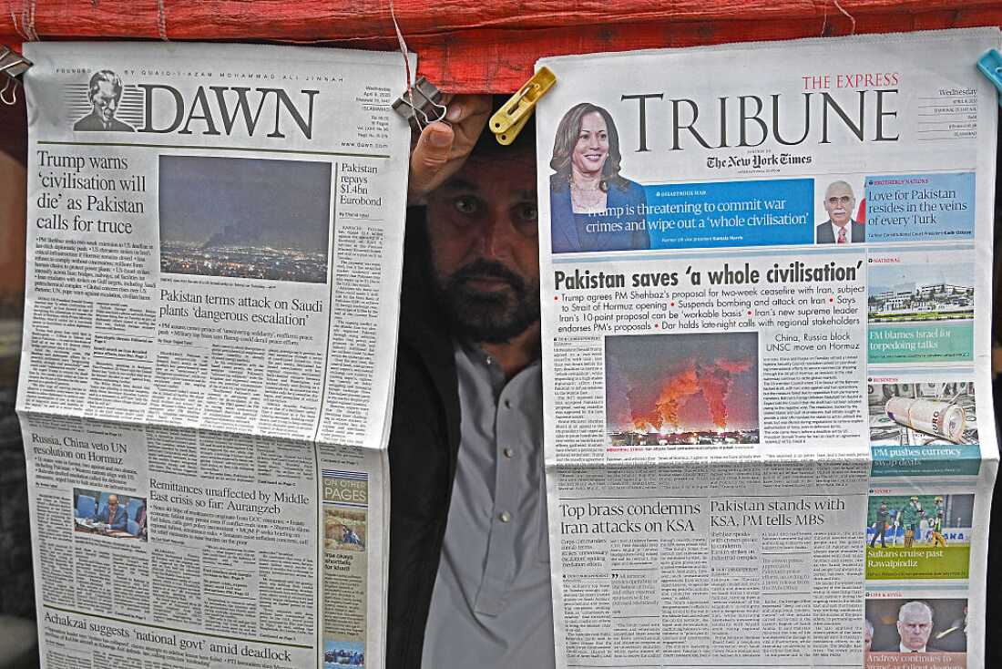
Pakistan Prime Minister Shehbaz Sharif, who has been acting as an intermediary between Tehran and Washington, said the ceasefire will take effect immediately, and includes “Lebanon and elsewhere.” The prime minister will remain at the forefront of negotiations in the coming week. He has invited delegations from the U.S. and Iran to “settle all disputes” in continued diplomatic talks in Islamabad on Friday.
A vendor displays morning newspapers at his roadside stall in Islamabad on April 8, 2026. Pakistan’s Prime Minister Shehbaz Sharif said on April 8 that the United States, Iran and their allies had agreed to a ceasefire “everywhere”, including Lebanon, following mediation by his government to stop weeks of fighting.
Aamir Qureshi/AFP via Getty Images
hide caption
toggle caption
Aamir Qureshi/AFP via Getty Images
Here are more updates from the region today:
Iran reaction | Dispute over Hezbollah | Shelly Kittleson freed
Iranian leaders hail ceasefire as victory
Iranian leaders are also touting the ceasefire as a victory, noting that the “criminal U.S.” has agreed to “the general framework” of Iran’s 10-point proposal.
“Good news to the dear nation of Iran! Nearly all the objectives of the war have been achieved,” the Supreme National Security Council said in a statement.
Iran officials warned that any deviation from the agreement could lead to future violence.
“Our hands are on the trigger, and the moment the enemy makes the slightest mistake, it will be met with full force,” the Supreme National Security Council said.
Iran’s foreign minister, Seyed Abbas Araghchi, thanked Pakistan Prime Minister Sharif for his role in the negotiations.
“If attacks against Iran are halted our Powerful Armed Forces will cease their defensive operations,” Araghchi said in a statement. He added: “For a period of two weeks, safe passage through the Strait of Hormuz will be possible via coordination with Iran’s Armed Forces and with due consideration of technical limitations.”
Israel disputes ceasefire over Hezbollah in Lebanon
Just hours after the pause in violence was announced there appeared to be disagreement over who would be granted a reprieve from the strikes.
Israeli Prime Minister Benjamin Netanyahu’s office said in a statement Wednesday morning that it supports Trump’s decision to suspend strikes against Iran for two weeks, but that the ceasefire doesn’t include Lebanon, despite Pakistan’s prime minister saying otherwise.
It’s unclear where negotiations stand regarding Iran’s position that it can continue its enrichment of uranium. In his statement, Netanyahu said Israel “supports U.S. efforts to ensure Iran no longer poses a nuclear or missile threat.
“Both parties have displayed remarkable wisdom and understanding and have remained constructively engaged in furthering the cause of peace and stability,” Sharif wrote in a post on X, and expressed optimism that the Islamabad talks would result in sustainable peace.
A man flashes the V-sign while driving a vehicle loaded with belongings through the al-Qassimyah area en route to southern Lebanon early on April 8, 2026, after the United States and Iran agreed to a two-week ceasefire. Israel renewed its strikes on southern Lebanon on April 8, state media reported, as the Israeli prime minister insisted the Iran war truce does not include Lebanon.
Kawnat Haju/AFP via Getty Images
hide caption
toggle caption
Kawnat Haju/AFP via Getty Images
Prior to the ceasefire agreement, Trump had threatened to destroy bridges, power plants and water treatment facilities; moves that would have imperiled the entire population of Iran.
His comments drew a rebuke from Pope Leo XIV, who called Trump’s threat to destroy Iran “truly unacceptable.”
He called on people to contact their political leaders and congressional representatives to press for dialogue.
“We have a worldwide economic crisis, an energy crisis, situation in the Middle East of great instability, which is only provoking more hatred throughout the world,” he said.
“Come back to the table – let’s talk, let’s look for solutions in a peaceful way,” he added.
Wide-scale destruction of infrastructure, without any distinction between civilian and military targets, would be considered a war crime under international and U.S. law, legal experts tell NPR.
American journalist Kittleson is freed
Freelance journalist Shelly Kittleson has been released a week after she was kidnapped by Kataib Hezbollah, the Iranian-backed Iraqi militant group.
“We are relieved that this American is now free and are working to support her safe departure from Iraq,” Secretary of State Marco Rubio wrote in a statement on X on Tuesday evening.
Kittleson, 49, has spent over a decade covering the Middle East, according to Columbia Journalism Review. She was captured by the militia group on March 31, in broad daylight on a Baghdad street corner. Her release was a multi-agency effort, according to Rubio.
U.S. journalist Shelly Kittleson poses for a cellphone photo in a cafe in Baghdad, Iraq, March 30.
AP
hide caption
toggle caption
AP
“The U.S. Department of State extends its appreciation to the Federal Bureau of Investigation, the Department of War, U.S. personnel across multiple agencies, and the Iraqi Supreme Judicial Council and our Iraqi partners, for their assistance in securing her release,” Rubio said.
He added: “Under President Trump, the wrongful detention or kidnapping of U.S. nationals will not be tolerated. We will continue to use every tool to bring Americans home and to hold accountable those responsible.”
Kataib Hezbollah, one of Iraq’s most powerful Shia paramilitaries, announced earlier on Tuesday that it was releasing Kittleson in appreciation of “the patriotic positions” of Iraq’s prime minister, who helped negotiate her release. It said she had to leave the country immediately.
The group in Iraq is not related to the Lebanese militant group Hezbollah. It’s part of a coalition of Iran-backed militias that have been attacking U.S. military and government targets in Iraq. The U.S. and Israel have launched airstrikes in response.
When Kittleson was kidnapped last week, the U.S. State Department said it had warned her of threats against her beforehand, and that it was working with the FBI to secure her release. The U.S. Embassy in Baghdad has said all American citizens should leave Iraq because of attacks.