Indianapolis, IN
2024 NBA All-Star weekend in Indianapolis updates – Indianapolis Recorder

With one of the world’s biggest spectacles coming to Indianapolis in less than two months, fans near and far are anticipating new experiences, A-list celebrities and a boom in the city’s economy. Here is what you need to know about the 2024 NBA All-Star weekend.
“I got the deluxe tour of all of the improvements of Downtown here [Indianapolis], quite remarkable,” NBA commissioner Adam Silver said in October 2023.
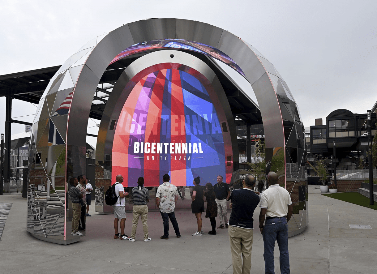
One of those improvements is the Bicentennial Unity Plaza, located near the north end of Gainbridge Fieldhouse, which officially opened in the summer of 2023. Nearly $30 million went into the construction of the Unity Plaza. The city also poured a couple of million dollars into renovating Downtown Indianapolis hotspots, such as Georgia Street, Monument Circle and the Indiana Convention Center, ahead of the festivities.
One of the biggest announcements Silver made to Hoosiers and NBA All-Star fans during his visit to Gainbridge Fieldhouse last summer is the return to the fan-favorite format of “Eastern Conference versus Western Conference” in the 2024 NBA All-Star Game.
“We thought it was time that since we are coming back to a traditional market, as Indianapolis is, as Indiana and all it means for basketball, that we are going to return to the classic format for our All-Star Game,” Silver said. “It will be East versus West, with the return to the four quarters, that we are all used to for a basketball game.”

Mayor of Indianapolis Joe Hogsett spoke about what the NBA All-Star festivities mean to the city. ” Nobody hosts like Indianapolis, nobody,” Mayor Hogsett said. “The NBA is a global game, and NBA All-Star is unique because it allows us to put our city on display for a truly international audience. With a projected impact of more than $320 million, the ripple effects of hosting this incredible event will be felt well into the future.”
Mayor Hogsett also said that “approximately 3,100 jobs will be created, supported or expanded to support this event.”
The last time Indianapolis hosted an NBA All-Star weekend was in 1985. The merriments took place at Market Square Arena and the Hoosier Dome, which have both since been decimated. The All-Star took place Feb. 10, which was also the day that Indianapolis received the most snow in 1985, recording approximately 5 inches.
Current Pacers Sports & Entertainment President Rick Fuson was a part of the 1985 All-Star Committee during the emphatic “White Christmas-styled” weekend almost 40 years ago. Fuson jokingly begged the powers that be for the city to avoid another snow-filled NBA All-Star Game.
“I think Commissioner Silver and the All-Star Game being here would be really good for the city,” Pacers fan Will Castetter said. “I think All-Star will bring a lot of publicity. People not from Indy will get to see that Indianapolis is a really great place to be and get to experience a bit of the great things going on in the city.”

Pacers Board of Directors member Stephen “Steve” Simon spoke about the beauty of All-Star weekend returning to Indianapolis. “There is so much to be excited about,” Simon said.
For more updates on NBA All-Star 2024 in Indianapolis, visit NBAevents.
“It is getting real; it [2024 NBA All-Star] is coming,” Simon said. Fuson piggybacked off Simon’s comment, stating, “Our city is ready.”
Contact multi-media staff writer Noral Parham III at 317-762-7846. Follow him on Twitter @3Noral. For more 2024 NBA All-Star weekend updates, visit our sports page here.


INDIANAPOLIS (WISH) — Staring Monday, Immigration and Customs Enforcement (ICE) will assist TSA airports across the country. A budget battle in congress is keeping TSA from getting paid, creating staffing issues.
Many travelers that spoke with News 8 say they weren’t expecting to see ICE during their Spring travel. Some say they are hopeful it could ease the long wait times. Others say it raises new concerns while traveling.
“TSA definitely needs some help right now, but what kind of security are [ICE] going to provide?” Hugo Lopez, who was traveling through the Indianapolis International Airport said. “Is it the same type of security they are doing in Minneapolis? You know, where even U.S. citizens are going to be concerned about now having the right paperwork.”
ICE is expected to support TSA teams at select airports, but they have not announced which airports ICE officers will be assigned to, other than the Hartsfield-Jackson Atlanta International Airport.
“They might be sent here to do something positive,” traveler Ade Yemi said. “They may end up doing something negative to a lot of people. I am just not one for it.”
Despite potential shorter wait times, many travelers told News 8, it’s not worth it.
“I mean regardless of the line, people have been able to navigate and get to their destination,” Yemi said. “I would like to keep it business as usual.”
“Personally, I would wait in the line because right now the problem is more economical than political,” Lopez said. “When I came out of El Paso, I thanked the TSA agent. I said ‘I appreciate what you guys are doing. You aren’t getting paid, but you are still here on the front lines.’”
Lopez says he would feel more comfortable with ICE around, under one circumstance, “If ICE personelle were to come here, probably without guns,” Lopez said. “People would feel safer around them. There is no need for them and there is already so many police forces here. We don’t need another federal entity with guns blazing.”
Federal officials have indicated that this task for ICE is not intended to conduct immigration enforcement activities. ICE is only meant to help with crowd control.

INDIANAPOLIS (WISH) — Record highs are in jeopardy with high temperatures in the low 80s for most. Scattered storms will develop later this evening after a very warm day.
TODAY: Mostly sunny to partly cloudy skies this afternoon. The cold front arrives sooner in north-central Indiana, where highs will get into the 70s and fall quickly. A slight (2/5) risk of severe storms is in place mainly after 7 PM south of I-70.

TONIGHT: At first, cells pop up before forming a line. Large hail is the primary threat, especially as the storm mode is cellular at the start. Once a line forms, the damaging wind threat will also be elevated. Tornado threat is very low, but not zero. Storms move south of south-central Indiana around 11 PM EDT. Low temperatures in the mid-30s.
TOMORROW: Partly cloudy, cooler. High temperatures in the low 50s.
7-DAY FORECAST: A gradual warm-up is anticipated this week. Scattered showers and storms move back in for Thursday. Otherwise, most of this forecasting period will be dry.

TONIGHT
A very mild night is on tap for Indianapolis with mostly clear skies and a low around 60. South southwest wind stays going near 5 to 10 mph, so the air should not cool off much at all overnight. Impacts are minimal, with good travel conditions and no weather hazards beyond the unusual warmth for late March.
TOMORROW
Sunday is the attention-grabber in this run. The day starts warm and mostly dry, then clouds increase with a chance of rain developing during mid to late afternoon before a chance of thunderstorms arrives toward evening. Highs reach the lower 80s, and south southwest wind increases to around 10 to 15 mph with gusts near 25 mph. The main impact is late-day storm potential after a very usable daytime stretch. A few strong to severe storms cannot be ruled out, so any evening plans need a weather check before heading out.
TOMORROW NIGHT
The front comes through Sunday night with a chance of thunderstorms early, then a chance of plain rain for a time before things taper off. Temperatures crash hard by daybreak, falling to the upper 30s, and the wind flips north around 10 to 15 mph with gusts to 25 mph. The biggest impacts are the evening thunder risk, wet roads, and then a much colder feel by Monday morning. This is the one period in the forecast with a meaningful hazard signal, even though coverage does not look widespread enough to make it an all-night washout.
MONDAY
Monday feels like a full reset after the weekend warmth. Skies turn mostly sunny, but highs only recover into the low 50s with a north wind around 10 mph and occasional gusts near 20 mph. It looks dry and bright, yet noticeably cooler, so the impact is mostly on comfort rather than travel or safety.
MONDAY NIGHT
Monday night turns quiet and chilly with partly cloudy skies and lows in the mid 30s. North wind eases to around 5 mph. No major hazards are expected, but it will feel much more like early spring again after the warm weekend.
TUESDAY
Tuesday trends a bit milder with mostly sunny skies and highs near 60. South southeast wind stays light around 5 mph. This looks like a low-impact day with decent outdoor conditions and no significant weather concerns.
TUESDAY NIGHT
Clouds increase Tuesday night, but it still looks dry with lows in the lower 40s. South southeast wind holds around 5 mph. Impacts remain minimal, with only a slightly cooler and cloudier feel overnight.
WEDNESDAY
Wednesday stays mostly cloudy and seasonably mild with highs in the mid 60s. Southeast wind runs around 5 to 10 mph. It is another fairly quiet day, though the thicker cloud cover keeps it from feeling as bright as Tuesday.
WEDNESDAY NIGHT
By Wednesday night, a small rain chance returns with a slight chance of showers and even a thunderstorm after 2 a.m. Lows hold in the lower 50s with a south wind around 5 mph. Impacts look limited for now, but it is the next window to watch for unsettled weather.
7 DAY FORECAST
The overall pattern features one more spring surge, then a quick correction, then a gradual warm back up. Tonight stays very mild, Sunday pushes into the lower 80s with the only notable storm chance of the period arriving late day into Sunday night, and Monday snaps back into the low 50s with a brisk north wind. From there the forecast turns quieter, with highs near 60 Tuesday and the mid 60s Wednesday before the next low-end rain chance sneaks in Wednesday night and likely grows a bit more by Thursday.

5 worst moments of March Madness Round 2, from Tyler Tanner’s miss to Kentucky flop

UPDATE: Plane found in swamp near Cleco lake, RPSO says

Maine Maple Sunday Weekend draws visitors to 100-plus sugarhouses statewide

What’s on Maryland lawmakers’ deadline day to-do list

Sweet 16 crossroads for Nimari Burnett journey to Michigan basketball

Florida High School Football Rankings: Top 25 teams – Oct. 21

How old is Bo Nix? What to know about Oregon quarterback ahead of 2024 NFL Draft

Cleary's 21 help Le Moyne down Central Connecticut State 69-64 in OT

99th annual Pony Swim held in Virginia

Indiana Members Credit Union announced as new anchor tenant at Bottleworks District

Video: Plane Collides With Vehicle at LaGuardia Airport

As cattle herds shrink and beef prices rise, investors back AI cow collars

French elections: Paris stays left as far right makes mixed gains

ICE officers set to deploy to airports as delays mount, border czar Homan confirms

Video: ICE Agents Will Be Deployed to U.S. Airports, White House Confirms
-

 Detroit, MI4 days ago
Drummer Brian Pastoria, longtime Detroit music advocate, dies at 68
-

 Oklahoma1 week ago
Family rallies around Oklahoma father after head-on crash
-

 Georgia1 week ago
How ICE plans for a detention warehouse pushed a Georgia town to fight back | CNN Politics
-
 Science1 week ago
Federal EPA moves to roll back recent limits on ethylene oxide, a carcinogen
-

 Alaska1 week ago
Police looking for man considered ‘armed and dangerous’
-

 Movie Reviews4 days ago
‘Youth’ Twitter review: Ken Karunaas impresses audiences; Suraj Venjaramoodu adds charm; music wins praise | – The Times of India
-

 World1 week ago
Thousands march worldwide in solidarity with Palestine, Iran on al-Quds Day
-

 World1 week ago
Jamal Rayyan, the first face of Al Jazeera, dies at 73