Indiana
Flash flood warning for Indiana County Thursday night

On Thursday at 9:01 p.m. a flash flood warning was issued by the National Weather Service in effect until 10:30 p.m. for Indiana County.
“At 9:01 p.m., Doppler radar indicated thunderstorms producing heavy rain across the warned area. Between 1 and 1.5 inches of rain have fallen. Additional rainfall amounts of 1 to 2 inches are possible in the warned area. Flash flooding is ongoing or expected to begin shortly,” explains the weather service. “Flash flooding of small creeks and streams, urban areas, highways, streets and underpasses as well as other poor drainage and low-lying areas.”
Locations impacted by the warning include Indiana, Clymer, Chevy Chase Heights, Lucerne Mines, Brush Vly and Yellow Creek State Park.
According to the weather service, “Turn around, don’t drown when encountering flooded roads. Most flood deaths occur in vehicles. Be aware of your surroundings and do not drive on flooded roads. In hilly terrain there are hundreds of low water crossings which are potentially dangerous in heavy rain. Do not attempt to cross flooded roads. Find an alternate route.”
Deciphering advisories, watches, and warnings: Understanding weather alerts
- Flash flood warning: Take action!
A flash flood warning is issued when a flash flood is imminent or occurring. If you are in a flood-prone area, move immediately to high ground. A flash flood is a sudden violent flood that can take from minutes to hours to develop. It is even possible to experience a flash flood in areas not immediately receiving rain.
- Flood warning: Take action!
A flood warning is declared when flooding is on the verge of happening or is already underway.
- Flood advisory: Be aware:
A flood advisory is released when flooding is not expected to reach a severity level necessitating a warning. Nonetheless, it can still cause considerable inconvenience and, without exercising caution, potentially lead to situations that threaten life and/or property.
- Flood watch: Be prepared:
A flood watch is issued when conditions are favorable for flooding. It does not mean flooding will occur, but it is possible.
Weather service flood safety guidelines: Weathering the storm
In flood-prone regions or while camping in low-lying areas, understanding and following the weather service flood safety guidelines can be a lifesaver:
Seek higher ground:
If you’re in a flood-prone area, or if you’re camping in a low-lying spot, move to higher ground as a first step.
Adhere to evacuation orders:
When local authorities issue an evacuation order, promptly comply. Before leaving, secure your home by locking it.
Disconnect utilities and appliances:
If time allows, disconnect your utilities and appliances. This reduces the risk of electrical hazards during flooding.
Steer clear of flooded basements and submerged areas:
Steer clear of basements or rooms where water has submerged electrical outlets or cords. This helps prevent electrical accidents.
Evacuate promptly for safety:
If you notice sparks or hear buzzing, crackling, snapping, or popping sounds, evacuate without delay. Do not enter water that may carry an electrical charge.
Stay away from floodwaters:
Never attempt to walk through floodwaters, even if they appear shallow. Just 6 inches of fast-moving water can forcefully sweep you off your feet.
Seek higher ground when trapped:
Should you become trapped by moving water, reach the highest point possible and dial 911 to contact emergency services.
During heavy rainfall, the risk of flooding is heightened, especially in low-lying and flood-prone regions. Always remember never to drive through water on the road, no matter how shallow it appears. According to the weather service, as little as 12 inches of rapidly flowing water can carry away most vehicles. Stay safe by being prepared and informed.
Navigating heavy rain: Essential safety measures for wet roads
Rain can turn roads into hazards. Stay informed and follow these weather service tips to ensure safety during heavy rainfall:
Beware of swollen waterways:
In heavy rain, refrain from parking or walking near culverts or drainage ditches, where swift-moving water can pose a grave danger.
Maintain safe driving distances:
Adhere to the two-second rule for maintaining a safe following distance behind the vehicle in front of you. In heavy rain, allow an additional two seconds of distance to compensate for reduced traction and braking effectiveness.
Reduce speed and drive cautiously:
On wet roads, reducing your speed is crucial. Ease off the gas pedal gradually and avoid abrupt braking to prevent skidding.
Choose your lane wisely:
Stick to the middle lanes on multi-lane roads to minimize the risk of hydroplaning, as water tends to accumulate in outer lanes.
Prioritize visibility:
Enhance your visibility in heavy rain by turning on your headlights. Watch out for vehicles in blind spots, as rain-smeared windows can obscure them.
Watch out for slippery roads:
The initial half-hour of rain is when roads are slickest due to a mixture of rain, grime, and oil. Exercise heightened caution during this period.
Keep a safe distance from large vehicles:
Large trucks and buses can reduce your visibility with tire spray. Avoid tailgating and pass them swiftly and safely.
Mind your windshield wipers:
- Overloaded wiper blades can hinder visibility. If rain severely impairs your vision, pull over and wait for conditions to improve. Seek refuge at rest areas or sheltered spots.
- When stopping by the roadside is your only option, position your vehicle as far off the road as possible, ideally beyond guardrails. Keep your headlights on and activate emergency flashers to alert other drivers of your position.
In the face of heavy rain, these precautions can make a significant difference in ensuring your safety on the road. Remember to stay informed about weather conditions and heed guidance from local authorities for a secure journey.
Advance Local Weather Alerts is a service provided by United Robots, which uses machine learning to compile the latest data from the National Weather Service.


INDIANAPOLIS (WISH) – The 2026 NCAA Division I Men’s Basketball Tournament’s Final Four is set.
Four teams have advanced to the Final Four and will compete for the national championship this upcoming weekend in Indianapolis.
The two national semifinal matchups will take place on Saturday. Tip times for the two games have been announced:
- 6:09 p.m. EDT – No. 3 seed Illinois vs. No. 2 seed UConn
- 8:49 p.m. EDT – No. 1 seed Michigan vs. No. 1 seed Arizona
The winners of Saturday’s games will then play in the National Championship Game on Monday, April 6.
Each game will take place inside Lucas Oil Stadium.

INDIANAPOLIS — Hundreds of Hoosiers gathered at the Indiana Statehouse Saturday morning as part of nationwide ‘No Kings’ events to voice their concerns about the current administration.
WATCH FULL STORY BELOW
Hundreds gather at Indiana State Capitol for ‘No Kings’ protest
“I’m out here today because what’s happening in our government is completely trash,” Donna Sipes told WRTV. “It’s wrong. We need to do something about it.”
“I’m tired of every single day when the TV comes on to see what stupid thing he’s done next,” Lindi Marti said.
WRTV
Attendees noted the growing popularity of the demonstrations.
“This is my fourth one to come to. I didn’t come to all of them when it was really cold, but I’m glad to see that they are getting a lot more people out here every time,” Marti added. “It seems like there’s more and more coming.”
Demonstrators highlighted specific foreign policy concerns, including the administration’s handling of the war in Iran.
“We’re bombing the heck out of them. We’re killing civilians,” Marti’s husband said. “We’re getting ready to send our Marines.”
WRTV

Others focused on the administration’s handling of immigration.
“That’s what I’m concerned about,” Reverend Kenny Little told WRTV. “Little kids, they’re taking them away from their family. And I’m just one of those people, I think everyone got rights.”
Indiana medical students also attended the rally to speak out against changes to the healthcare system.
“We’re really worried about the attacks on the health care system in general, but with Medicaid… current estimates range from anywhere from 325,000 to 450,000 Hoosiers will lose coverage by 2032,” Wade Catt said with concern.
WRTV
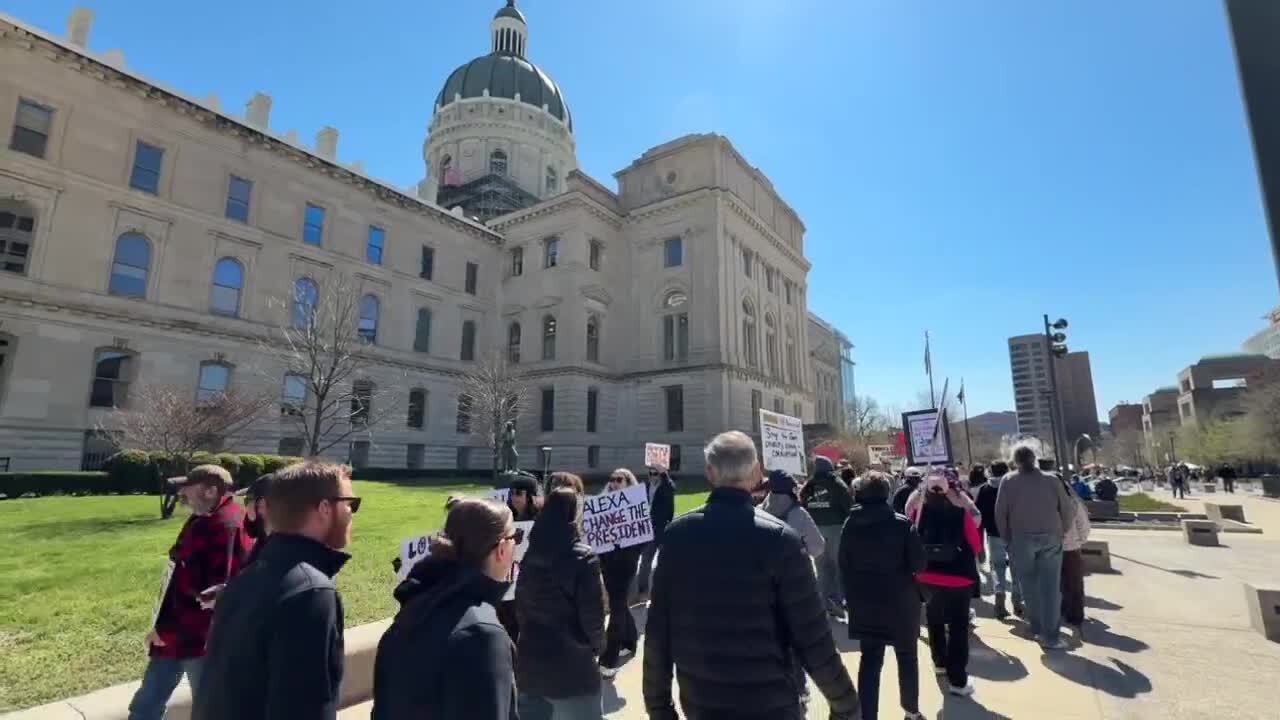
With midterm elections approaching later this year, attendees emphasized the importance of now taking action at the ballot box.
“If we don’t vote, then things are gonna not, they’re gonna stay the same,” a protester said.
Meanwhile, Indiana Lieutenant Governor Micah Beckwith says he’s happy to see Hoosiers exercise their First Amendment right to protest.
However, he takes issue with the idea that President Trump is acting like a king. Beckwith says the fact that people have the freedom to protest is proof that the president is not acting like a tyrant.
He acknowledges that bridging the gap between the sides is probably an uphill battle, but believes communication is key.
“I think when you sit down with people face to face, you’re confronted with humanity. There’s another human sitting across that table from you and talking to you. And so, all I have to say, I think that’s probably the thing I would encourage all Hoosiers to do is say, ‘Hey, if you don’t agree with somebody or if you don’t like somebody, why don’t you try grabbing coffee with them? And give it 30 minutes, and just see what happens.’ I bet most of the time people will walk away with a much softer heart and spirit towards that person before they came in,” Beckwith said.
Beckwith is currently on a 92-county tour of the state. He says all sides are welcome to attend his events.
__

INDIANAPOLIS (WISH) — Police say one “young man” is dead after a shooting at the 1200 block of Rue Rabelais at about 7:19 p.m. according to the Indianapolis Metropolitan Police Department.
That is near the intersection of 56th Street and Binford Boulevard.
Police say the victim was taken to Riley Hospital where he later died. Investigators say they are still working to identify the victim.
There was no known information about a suspect. Police did say that they believe this is a targeted incident.
There was no other information immediately available.
This story has been updated with information from the Indianapolis Metropolitan Police Department.

Dallas Jenkins says he is the ‘evangelical mascot of the LDS church’ and talks Easter celebrations

New video shows aftermath of police shooting in Downtown Miami

Boston Celtics Star Jayson Tatum Made History In Hornets Game

Game Thread: Denver Nuggets vs Golden State Warriors. March 29th, 2026. – Denver Stiffs

Trio helps Ottawa beat Seattle 2-0, spoiling return of Torrent captain Hilary Knight

Florida High School Football Rankings: Top 25 teams – Oct. 21

How old is Bo Nix? What to know about Oregon quarterback ahead of 2024 NFL Draft

Cleary's 21 help Le Moyne down Central Connecticut State 69-64 in OT

99th annual Pony Swim held in Virginia

Indiana Members Credit Union announced as new anchor tenant at Bottleworks District

Scathing report claims nation’s oldest labor union ‘betrayed’ MAGA members through ‘shocking’ spending

Republican US lawmaker demands Congress vote on any Iran troop deployment

So you went to a No Kings protest. Now what?

JD Vance says he was ‘obsessed’ with UFOs, believes aliens are actually ‘demons’
The EU's recipe for trade deals : easy on beef, tough on wine
-

 Sports1 week ago
IOC addresses execution of 19-year-old Iranian wrestler Saleh Mohammadi
-

 New Mexico1 week ago
Clovis shooting leaves one dead, four injured
-

 Miami, FL4 days ago
Jannik Sinner’s Girlfriend Laila Hasanovic Stuns in Ab-Revealing Post Amid Miami Open
-

 Tennessee6 days ago
Tennessee Police Investigating Alleged Assault Involving ‘Reacher’ Star Alan Ritchson
-

 Minneapolis, MN4 days ago
Boy who shielded classmate during school shooting receives Medal of Honor
-

 Politics1 week ago
Schumer gambit fails as DHS shutdown hits 36 days and airport lines grow
-

 Science1 week ago
Record Heat Meets a Major Snow Drought Across the West
-

 Technology1 week ago
YouTube job scam text: How to spot it fast