Wyoming
50-Degree Temperature Plunge, Snow On The Way For Much Of Wyoming

Enjoy the unseasonably warm April weather while it lasts, because it’ll be gone by Thursday.
A slow-moving cold front will move across Wyoming between Wednesday night and Friday. When it does, temperatures will drop up to 50 degrees in some places, and the entire state will get some snow.
“At this time of year, you can see the pendulum swing from one direction to another very quickly,” said Cowboy State Daily meteorologist Don Day. “We’re going to see equal but opposite extremes in temperature on Thursday and Friday, and just about everyone’s going to see snow.”
Pendulum Swings
Day categorized the incoming cold front as “a true taste of winter” returning to Wyoming. That’s not uncommon in April, but the intense reversal will catch a lot of Wyomingites off guard.
“Last week, we had temperatures in the 70s and 80s,” he said. “This Friday, temperatures will be more than 50 degrees colder in places. I’m looking at 32 degrees in Cody, 28 degrees in Cheyenne and 25 degrees in Laramie. And those are the highs.”
Thursday night and Friday morning temperatures could be in the upper teens and lower 20s, and Day wouldn’t be surprised to see subzero temperatures in Yellowstone National Park.
However, Day wouldn’t categorize this as an extreme switch, especially during a historically volatile month like April. It’s just the luck of the draw in Wyoming.
“One thing about Wyoming is that we’re situated to be affected by air masses from much different source regions,” he said. “¥ou get air out of the deserts today and tomorrow, followed by air out of the Pacific Northwest on Thursday and Friday.
“Sometimes, those air masses switch in less than 24 hours. But the pendulum swinging is normal in April. People talk about what the normal highs and lows should be, but all normal are averages of the extremes.”
When It Snows, It Pours
Between Wednesday night and Friday, nearly all of Wyoming will see some precipitation, probably in the form of snow. However, there’s still some uncertainty about how much precipitation will fall and the proportion of wet snow to cold rain.
“The precipitation moving in with the front may start as rain in some places, or may be all snow in other places,” said meteorologist Celia Hensley with the National Weather Service office in Riverton. “The biggest question mark with this forecast is how intense will it be snowing.”
Hensley said there could be some snow accumulation depending on ground temperature. Snow is expected to start sticking on grassy surfaces, but it could get cold enough to form on roads and highways, especially overnight.
“With temperatures right around that freezing mark, the precipitation should mostly be snow,” she said. “However, given our recent warmth, the time of year, and sun angle, impacts to travel on roadways during the daylight hours should be minimal. Higher elevation areas like mountain passes, Wind River Canyon, and Casper Mountain will be impacted more than lower elevation areas.”
Between Wednesday and Thursday, the entire state of Wyoming could receive up to half an inch of precipitation, rain, or snow.
According to NWS Riverton, communities like Cody, Casper, Buffalo, and Riverton have an 80% to 95% chance of getting over an inch of new snow by Saturday. Lander, meanwhile, has an 85% chance of seeing over four inches of snow during the same period.
“We’re looking at anywhere from three-tenths of an inch of moisture on the low end,” Hensley said. “Some places, especially in the mountains, may see up to an inch of moisture.”
This is one of those cold fronts where a few hundred feet could make all the difference. Hensley said it will be entirely dependent on air and ground temperatures once the snow starts to fall.
“What could be rain or light, misty snow in downtown Riverton could be heavy snow at the NWS Riverton Office, 500 feet higher up,” she said. “A few hundred feet of elevation could make all the difference in snowfall and whether it’s accumulating on roads.”
Will It Be Enough?
Michael Natoli with the NWS Office in Cheyenne is anticipating the “abrupt end” of the warm weather Wyoming has been enjoying for the last two weeks. The cold front should bring its full brunt to southeast Wyoming by Thursday evening.
“We may see some rain showers right at the beginning, but we expect this to transition to snow pretty quickly,” he said. “Amounts are still uncertain, but there is a potential for some accumulating snow, even in the valleys.”
The big question is whether this weather system will be enough to alleviate the drought gripping the southeast corner of Wyoming. Natoli said every drop of moisture is welcome, but the monthly threshold has yet to be reached.
“We’re headed into our wettest time of the year, but just one of these storms is not enough to dent the drought,” he said. “In Cheyenne, the average liquid precipitation in April is close to two inches through the month. So far, we have received essentially nothing. Half an inch of precipitation from this storm is the most likely scenario right now, which is a good amount, but we have a ways to go to make up the long-term deficit.”
Meanwhile, daytime highs in southeast Wyoming will be in the 20s and 30s. There’s no escaping the impact of this winter weather system.
“It’s going to cool down pretty quickly,” Natoli said. “This is going to be a pretty cold storm.”
Morning Warning
The consensus among Wyoming meteorologists is that the incoming cold front will be a full-fledged winter weather system and should be treated as such. That means anyone traveling will want to anticipate what they’ll encounter, depending on their timing.
“I do think there’s going to be travel problems, especially during the night hours,” Day said. “When it’s that cold, the snow accumulates, and ice could accumulate.”
Daytime travel shouldn’t be much of an issue, thanks to the sun angle keeping things just warm and bright enough to melt accumulated ice and snow. According to Day, the biggest “headaches” will be the consistently problematic areas like South Pass, Powder River Pass, Teton Pass, Togwotee Pass, and the section of I-80 between Cheyenne and Rawlins.
“It can freeze and snow during the day, but the April sun is intense enough to get through the clouds,” he said. “The times to watch out for during these April snow events are nights and mornings when it’s dark, and things ice up quickly, and all these areas will be problems overnight on Wednesday, Thursday, and Friday.”
Get It While It’s Good
The slow-moving cold front will have moved on by the weekend, and temperatures are expected to moderate to seasonal normals. However, Day said this pattern will set a precedent for the rest of April.
“Next week looks cold and unsettled, with more chances for rain and snow,” he said. “Temperatures over the weekend will still be chilly. It’s not going to stay as cold as it’ll get in Friday, but I expect it to be cooler and unsettled all the way through the end of April.”
According to Day, Wyoming wants it that way. Cooler temperatures will slow the melting of the state’s snowpack, moderating the amount of water flowing into the river basins, fields, and reservoirs.
“You don’t want it to be too warm in April,” he said. “Then people start freaking out about the runoff and the mountains accelerating too quickly. You want it more metered and spread out, and this system will slow down the melt in the high country significantly.”
There could be another pendulum swing into the 80s before the end of April, but Day doesn’t think it’s likely. That leaves him with a simple message of calm before the storm.
“Enjoy the next two days,” he said, “because it’s going to be a bit before it gets this nice again.”
Andrew Rossi can be reached at arossi@cowboystatedaily.com.
Wyoming
At 6,000-year-old crossing, Gov. Gordon OKs Wyoming’s first-ever designated pronghorn migration route – WyoFile

SUBLETTE COUNTY—Gov. Mark Gordon heralded Wyoming’s first-ever designation to protect a pronghorn migration corridor — a more than 2 million-acre web of habitat — at Trapper’s Point, which he called a “wonderful passageway.”
“How incredibly valuable it is that you are standing here today,” Gordon told the crowd, “to witness this remarkable moment.”
Gordon commemorated the moment with his feet planted on the narrow bulge of high country that splits the Green and New Fork rivers. Thousands of years ago, the site was a well-used hunting ground for Native Americans — it’s the earliest known killing and processing site for pronghorn in North America. Now it boasts a wildlife overpass.
No pronghorn were to be seen during the especially windy Friday afternoon gathering, which attracted 75 attendees from nearby Pinedale and other western Wyoming communities.
Now Trapper’s Point is officially classified as a “bottleneck” for the Sublette Pronghorn Herd — one of 13 such bottlenecks. That classification is supposed to prevent any surface-disturbing activity, with the intent that pronghorn can keep passing through Trapper’s Point for generations to come.

Protecting the ability of the fleet-footed, tawny-and-white ungulates to migrate is a “key factor” in sustaining their population, Wyoming Game and Fish Director Angi Bruce said.
“This becomes even more important in severe winters or extreme droughts,” Bruce said. “Pronghorn are long overdue for recognition.”
Pronghorn in Sublette, Teton, Sweetwater and Lincoln counties travel a long road — some migrate more than 200 miles to escape harsh winters, trekking south into the lower Green River Basin, a semi-arid sweep of sagebrush steppe between Pinedale and Rock Springs. Then in the spring, they retrace those paths, returning to summer ranges, lush with verdant vegetation, even going as far as Grand Teton National Park.
There was also a long road of bureaucracy to get to this point.
Nearly three decades of effort preceded the formal designation of the migration routes used by the Sublette Pronghorn Herd, which is the farthest-traveling and among the largest pronghorn herds in the West.
Jackson Hole biologists long knew that the valley’s pronghorn left in the winter. But details were hazy on where they went and how they got there until around the turn of the century. Using data from tracking collars, biologists like Joel Berger, Steve Cain, Hall Sawyer and Doug Brimeyer helped delineate the route.

In 2008, a Bridger-Teton National Forest plan amendment established a portion of the path as the nation’s first designated wildlife migration corridor.
Popularized by its branding as the “Path of the Pronghorn,” the route has received press in national publications like High Country News and the New York Times.
But the southern reaches of the migration through the energy-rich Green River Basin have faced major political opposition since the early 2000s. Wyoming first attempted to protect those travel corridors in 2019, under a policy administered by the Wyoming Game and Fish Department. That effort was halted after a coalition of industry trade groups and counties protested.
Then, in early 2020, Gordon revamped the migration policy with an executive order. Still, the Sublette Pronghorn Herd proposal gathered dust, even as development threatened the route.
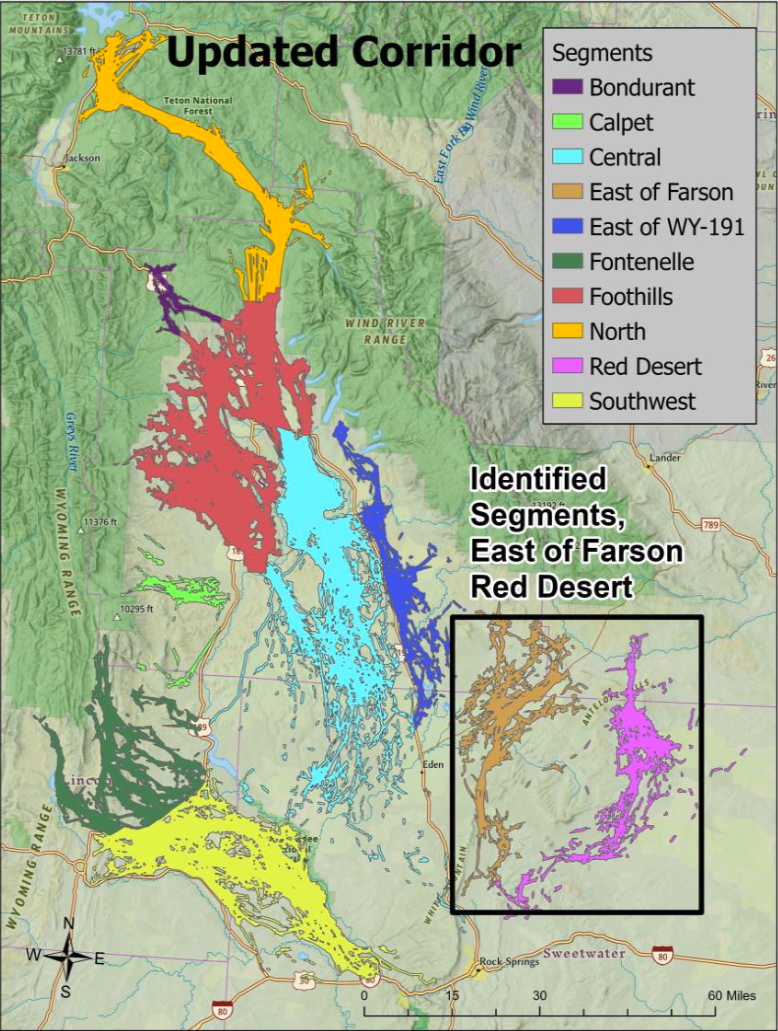
Game and Fish revived efforts to protect the migration in late 2023 and early 2024. Biologists pulled together one of North America’s most comprehensive migration datasets, benefiting from approximately two decades of GPS collar information collected from more than 400 pronghorn.
Some controversy followed the process until near the end. There was a debate about whether to designate the migration’s two easternmost segments, in the Red Desert and east of Farson. The Game and Fish Department proposed excluding the routes, but was overridden by its commission. Then Gordon upended that decision, excluding the two segments.
Vetting the migration corridor through a Gordon-appointed working group was the second-to-last step in the designation process.
“Today’s designation demonstrates that voluntary, locally driven conservation works,” said Robb Slaughter, who chaired the group, during the commemoration at Trapper’s Point.
Time will tell if that’s the case. Wyoming’s migration policy is, by design, permissive of development. Private land is exempt from protections, and designation is not an assurance that new stressors won’t be added to the landscape.

“Today is not the end of the process,” Slaughter said. “It’s the beginning of the next chapter. Continued monitoring, adaptive management, research, and cooperation will ensure these recommendations remain effective as conditions change.”
But Friday was the end of the migration designation process. The governor’s informal OK — no signature was needed — was the last step, said Sara DiRienzo, the governor’s deputy policy advisor.
Wildlife advocates celebrated the moment.
“This is historical,” Bruce said. It’s the first effort to protect the full length of a pronghorn migration corridor in the nation, she said.
Wyoming
Politicians mull action as details of alleged abuse, falsified records at Wyoming Boys’ School become public

by Maya Shimizu Harris, WyoFile
The photo of an Iraqi inmate strapped by U.S. military police to a restraint chair in the Abu Ghraib prison sparked “a collective cry of ‘torture,’” Sue Burrell, an attorney and author of a 2009 paper on restraints used at U.S. youth detention centers, recalled of a 2005 Newsweek magazine cover.
For Burrell, however, it stirred a more personal response. “All I could think of was that the restraint chair in the photo was almost exactly like the one we had recently seen in a juvenile detention facility in the United States,” she stated in the paper’s preface, which showed the Newsweek photo next to another of a restraint chair at a U.S. youth detention center.
A June court filing in an ongoing lawsuit alleging abuse at the Wyoming Boys’ School, a state facility for delinquent juveniles, almost mirrors the 2009 paper’s preface, showing two side-by-side images, one of a boy in a restraint chair with a white bag over his head and another of him huddled alone in the corner of a cinderblock room. Above the images is a quote attributed to one of the defendants: “[The] best part of the chair is watching the kids cry and scream like a fucking child . . . that’s what makes it worth it.”
“I had never thought I would see a photo of a child with a bag over their head, like they’re being water boarded,” said Rep. Karlee Provenza, a Laramie Democrat who has advocated for juvenile justice reform in Wyoming.
It’s unlikely the images — which sparked outrage on social media — would have come to light if it weren’t for the lawsuit. For years, lawmakers and advocates have grappled with the lack of transparency around the Wyoming Boys’ School specifically and the state’s juvenile justice system more broadly.
Citing confidentiality laws, the Wyoming Department of Family Services, which oversees the boys’ school, has declined to release information about abuse allegations at the facility. DFS treats allegations of abuse or mistreatment at the detention center as Child Protective Service cases. Child Protective Services and the boys’ school are both under the auspices of DFS, meaning the agency investigates itself without oversight or transparency.
“We can’t trust the government to investigate itself,” Provenza said. “We’ve seen how that falls short, so it might be that it needs to be a broader conversation and not just targeted at DFS.”
A legislative catch-22
Lawmakers — those responsible for crafting laws that regulate the state’s juvenile justice system — also struggle to access data that could help them see more broadly how Wyoming’s juvenile justice system works. That’s because Wyoming doesn’t have a statewide system. Instead, each county takes a different approach, making it difficult to collect uniform data showing how kids move through the system and what outcomes they experience.
For years, legislators have sought new laws to standardize data collection on Wyoming’s juvenile justice system and allow DFS to share it. They hoped the data would show how children move through the system and what their outcomes are, which could help lawmakers pinpoint what’s working and what needs to improve.
But fears of government overreach have stymied efforts to pass legislation that would increase transparency. Some lawmakers who opposed these measures have suggested studying the juvenile justice system more before passing any laws.

“My recommendation would be that the Legislature take some time to really put together a good dive into the juvenile justice system and all of its programs together to be able to make one clear, concise bill that fixes a plethora of problems,” Casper Republican Rep. Jayme Lien told her colleagues before voting against a measure to change Wyoming’s confidentiality statutes.
That idea puts the Legislature in a catch-22: to study the state’s juvenile justice system, lawmakers need data. But when the Joint Judiciary Committee tried to do a deep dive into juvenile justice in 2021, it quickly realized that access to that data would require a statute change.
Lien didn’t respond to a message from WyoFile sent Monday inquiring about whether she had looked into the topic and had interest in supporting any related legislation this upcoming session if reelected.
Political will?
Juvenile justice reform isn’t an interim priority for the Joint Judiciary Committee this year. “It doesn’t need any study,” Rep. Art Washut, the Casper Republican who chairs the House Judiciary Committee, said. “We know what it is, we know what the needs are. It’s just a political will to pass legislation.”
“It’s always been very frustrating, sort of circular arguments that we haven’t done this, so we can’t do that,” Donna Sheen, the former executive director of the Wyoming Children’s Law Center, said. “But the bottom line is that we continue to leave children in really harmful places.”
When it comes to how children are treated at juvenile facilities, Wyoming’s current regulations are “pretty minimal,” Sheen said, and don’t differentiate between facility types. “So in that respect, there are very minimal expectations or rules around how children can be treated.”
Through materials provided in discovery, including depositions — testimony given under oath — images and records, the lawsuit against the boys’ school provides a window into what a child might experience at the facility. Besides providing images, the latest response in the case also includes new allegations that boys’ school employees were encouraged to downplay the use of force against residents in incident reports.
“In light of what’s coming out from this lawsuit, it is clear that we need to make changes,” Provenza, the Laramie Democrat, said in a phone call.
What those changes might look like is unclear right now. “I think everyone is digesting what’s coming out from the lawsuit, and then trying to figure out: What are the policies that need to change within the agency? What are the guardrails that the state needs to put in place to protect kids?”
Provenza said over text that she’s “hopeful” other lawmakers “will see the need for statute changes” and will also be willing to work on juvenile justice reforms come the next legislative session.
More broadly, Provenza said she would also prioritize putting a version of past confidentiality amendment bills into statute. “Without that change in statute, we are going to have a difficult time evaluating any program effectiveness,” she said in a follow-up text message.
Governor, candidates react
Gov. Mark Gordon, who appointed DFS director Korin Schmidt, declined to comment on the specifics of the case when asked by WyoFile if he thinks Wyoming should have stronger guardrails on the use of solitary confinement and force against children in state custody and if the lawsuit’s allegations call for an independent review of the boys’ school and DFS’ oversight of the facility.
“Building upon the commitment I witnessed firsthand during my mental health town hall and visit to the Wyoming Boys School in 2023, the safety and security of the students and staff at the facility are paramount to me,” he said.
The governor said that he had been “in direct contact” with Schmidt, who “verified and assured” him that “the youth currently residing at the school are safe and receiving proper care.” He also mentioned that most of these allegations “were made roughly four years ago.” In 2022, WyoFile and the Casper Star-Tribune reported that the use of force, restraints and confined isolation had increased at the boys’ school.

Gordon will finish his final term as governor in November. There are four Republicans and a Democrat vying to replace him. WyoFile posed the same questions to these candidates.
“Wyoming needs a juvenile justice system that protects communities, holds offenders accountable, and ensures children in state custody are treated humanely, safely, and with appropriate guardrails that focus on rehabilitation,” State Superintendent of Public Instruction Megan Degenfelder, a Republican running for governor, said in a statement to WyoFile.
“I take these allegations seriously, children in state custody are the responsibility of the State of Wyoming.”
If elected, Degenfelder said she would “support an independent review” of the boys’ school, including its use-of-force policies, isolation practices, staff training, reporting and transparency for lawmakers and the public.
Republican gubernatorial candidate Brent Bien also said in a statement to WyoFile that he would support an independent review of the allegations. “These are minor children in state custody. As such, the state does have a duty to not only maintain order, but to also ensure accountability while still protecting that child.”
“Though I can not prejudge a lawsuit, as Governor, I would not ignore any allegations that involve excessive force, isolation, ‘restraint chairs,’ or any other actions that may harm children in state custody.”
Wyoming, he said, should have “clear guardrails” for juveniles in state custody. If elected, he would support legislation requiring reporting, “body/video records,” limits on isolation and restraints, trauma-informed training and regular oversight of “all juvenile facilities.” Bien said those measures should include “strong consequences” for violations.
“The recent allegations about the Wyoming Boys’ School are deeply concerning,” Sen. Eric Barlow, a Gillette Republican who served as Speaker of the House, said in a statement to WyoFile. “Every young person in the state’s care deserves to be safe and treated with dignity. Wyoming families want their kids close to home, getting help and support.”
In 2025, Barlow voted in favor of Senate File 157, “Department of family services-confidentiality amendments-2,” one of many attempts over the last couple of years to improve juvenile justice data sharing, before it died in the House Judiciary Committee.
Republican candidate Curt Blake did not respond to WyoFile by publishing time.
The state defendants in the boys’ school lawsuit have until Friday to file their reply supporting their request for summary judgement — when a court decides a matter before a case goes to trial.
This article was originally published by WyoFile and is republished here with permission. WyoFile is an independent nonprofit news organization focused on Wyoming people, places and policy.
Related
Wyoming
Dan Speas Fish Hatchery temporarily closed to visitors as construction begins on new cool-/warm-water expansion

CASPER, Wyo. — On Thursday, the Wyoming Game and Fish Department announced that the Dan Speas Fish Hatchery will be temporarily closed, beginning June 25, due to the construction of a brand-new, state-of-the-art cool-/warm-water fish production facility.
A release from Game and Fish says that the brief pause in public access is a necessary step to ensure the safety of visitors and staff during the heavy-lifting phases of the project.
“We had hoped to keep access open to the hatchery, but we have discovered there will be too many safety hazards during the demolition phase of construction,” said Lars Alsager, Game and Fish superintendent of Dan Speas. “The Department will reassess the closure in the fall of 2026, once initial demolition and foundational work are safely wrapped up.”
As Wyoming’s largest producer of fish for stocking, the Dan Speas Fish Hatchery — along with the state’s nine other fish hatcheries — will continue its normal cold-water fish production uninterrupted throughout the entire construction process.
Once the expansion is complete, the new facility will dramatically boost Game and Fish’s ability to manage diverse recreational fishing opportunities across Wyoming by raising sport fish locally, rather than importing them from other states.
Anglers can look forward to high-quality, in-state production of walleye, sauger, crappie, bluegill, largemouth bass and channel catfish.
“This project marks a thrilling milestone for Wyoming’s outdoor community, ensuring a robust, self-sustaining future for cold, cool and warm-water sport fishing right here at home,” adds Alan Osterland, chief of fisheries.
The release notes that the Wyoming Game and Fish Department is committed to keeping the community in the loop every step of the way. They included a brief snapshot of what to expect throughout the project:
- Fall 2026: Demolition and foundation work conclude, and the department reassesses public access to the facility.
- Fall 2027: Construction of the new cool-/warm-water fish production facility officially ends.
- Spring 2028: The first batch of cool- and warm-water fish will be produced and prepared to stock Wyoming waters.
“The Wyoming Game and Fish Department extends its sincere thanks to the public for their understanding and cooperation as we build a premier fishery asset for generations of anglers to come,” the release states.
Related
-

 Vermont45 seconds ago
West Rutland man dies in hit-and-run, police seek vehicle
-

 Virginia6 minutes ago
Vandals smash windows of nearly 3 dozen cars in Arlington Mill
-

 Washington13 minutes ago
The Washington Capitals Select Oliver Suvanto | Washington Capitals
-
 Wisconsin16 minutes ago
From bodybuilding to business: Wisconsin entrepreneur builds success with Bulk Butter
-

 West Virginia21 minutes ago
West Virginia First Foundation advances key initiatives at second quarterly board meeting
-

 Wyoming28 minutes ago
At 6,000-year-old crossing, Gov. Gordon OKs Wyoming’s first-ever designated pronghorn migration route – WyoFile
-

 Crypto31 minutes ago
SpaceX Lands Nasdaq-100 Spot Weeks After Record IPO
-

 Finance36 minutes ago
Hong Kong vows stronger exchange with reforms, bond futures and gold push

