Connect with us

Alaska

West High football pulls away from East late with key defensive plays

Published

on

West High football pulls away from East late with key defensive plays


The final box score of Friday night’s Cook Inlet Conference football clash between crosstown rivals West Anchorage and Bettye Davis East indicated a nearly 20-point victory for the visiting Eagles.

However, the game of the week didn’t disappoint or lack for action before the Thunderbirds ultimately fell 41-22 on their home turf to West, the team that may very well be the most complete team in the state at the Division I level.

“To come out on top is a pretty good feeling, but at the end of the day, these kids worked so hard for it this week and put in a solid week of practice,” West coach Tim Davis said.

Through the first three quarters, it was anyone’s game as neither team held the momentum or a lead for long. The teams would answer one impressive drive with another impressive drive, and trade big play for big play.

Advertisement

“It snowballed and that scoreboard was nowhere near the game that it was,” Davis said. “It didn’t tell the story and we know that. We’re going to celebrate this one but just like Cinderella, when that clock strikes midnight, we’re on to the next one.”

The heavyweight bout that began as a back-and-forth affair turned in West’s favor in the fourth quarter when the Eagles scored three unanswered touchdowns in just over two minutes of game time, taking back the lead for good.

First came a 26-yard strike from senior quarterback Azariah Atonio to junior wide receiver Ariel Sanchez that gave the Eagles a 27-22 lead after a failed two-point conversion at the 7:51 mark.

Following an interception from junior safety Dylan Sanders near midfield that he returned to the East 7-yard line, the Eagles were back into the end zone after back-to-back carries by senior running back Davis Iloilo. That put West up by two scores at the 6:26 mark.

“It was a big play for the offense to get another score on the board to finish this game off,” Sanders said. “It was just an instinctive play.”

Advertisement

The final knockout blow was dealt when junior defensive end Leonidas Mata picked up a fumble by East quarterback Austin Johnson and proceeded to rumble 30 yards back the other way for a touchdown with 5:40 left in the game.

Sanders credits the relentless pressure generated by the Eagles’ defensive line in the second half as the key to forcing the two late turnovers that turned the tide.

“They’re just dogs down there,” Sanders said. “I only got a couple tackles, but all of them worked their butts off.”

Sanders was one of three Eagles to record interceptions in the game. In the third quarter, senior Aaron Hampton hauled in a tipped pass that bounced off the hands of an East receiver. Junior linebacker Christian Faletoi also had a third-quarter interception when he jumped an underneath route on the next East drive.

“Dylan Sanders is probably the best backyard football player west of the Mississippi,” Davis said. “The kid is just all over the place playing backyard football, catching tipped balls and trying to take them to the house.”

Advertisement

The result marked the first loss to Alaska competition for East this season, and the second victory for West over their crosstown rival since 2020.

It was especially meaningful for Atonio, who began his high school career at East. He was elated that perhaps his last time on that field ended with him walking off victorious as an Eagle.

“It means everything,” he said. “I transferred over here looking for a fresh start, and that’s what they gave me. Every opportunity was taken and we took off from there.”

[Previously: Anchorage’s crosstown high school football rivals rally around their unexpected starting quarterbacks]

He recorded the first two touchdowns of his hat trick in the first half on scrambles of 11 and 10 yards to give his team a 13-6 lead at halftime. East drew first blood on a 3-yard touchdown pass from Johnson to junior fullback Pusa Lilo in the first quarter.

Advertisement

“(Atonio) ran the ball, he played tough, he threw the ball and responded to adversity well,” Davis said.

East recaptured the lead 14-13 on a 5-yard touchdown from senior running back Saumani Atiifale followed by a successful two-point conversion.

The Thunderbirds’ lead wouldn’t last long as the Eagles answered quickly with a swift five-play drive that was sparked by three straight Iloilo runs for a combined 23 yards. It was capped off by a 20-yard touchdown run from senior Mason Tanoa, who lined up at quarterback in a wildcat formation. Tanoa ran in a two-point conversion as well.

“Davis (Iloilo) is a bulldozer,” Atonio said. “Once he gets the ball, there’s no stopping him.”

East answered right back with a run-heavy scoring drive of its own in which Johnson only threw the ball twice. The second attempt resulted in an 8-yard touchdown catch and run by junior wide receiver Brandon Young, who extended the ball over the goal line. The Thunderbirds then took the lead on another successful two-point conversion from Atiifale that looked short initially but was called good after officials conversed.

Advertisement

Atonio believes that this statement win over his former team will not only serve as huge confidence booster for his current team, but also send a clear message to rest of the state about what the Eagles are capable of.

“It tells them that we’re here,” he said. “No one believed in the beginning and everybody had their doubts, but they should know by now.”

[Split by grade, Anchorage XC runners relish the competition on a mud-splashed course]


Source link

Advertisement

Alaska

As Alaska sees a spike in Flu cases — another virus is on the rise in the U.S.

Published

on

As Alaska sees a spike in Flu cases — another virus is on the rise in the U.S.


FAIRBANKS, Alaska (KTUU) – Alaska has recently seen a rise in both influenza and respiratory syncytial virus, better known as RSV. Amidst the spike in both illnesses, norovirus has also been on the rise in the United States. The Centers for Disease Control and Prevention (CDC) says it’s highly contagious and hand sanitizers don’t work well against it.

Current data for Alaska shows 449 influenza cases and 262 RSV cases for the week of Jan. 4. Influenza predominantly impacts the Kenai area, the Yukon-Kuskokwim Delta, and the Northwest regions of the state. RSV is also seeing significant activity in the Yukon-Kuskokwim Delta and Anchorage.

Both are respiratory viruses that are treatable, but norovirus — which behaves like the stomach flu according to the CDC — is seeing a surge at the national level. It “causes acute gastroenteritis, an inflammation of the stomach or intestines,” as stated on the CDC webpage.

This virus is spread through close contact with infected people and surfaces, particularly food.

Advertisement

“Basically any place that people aggregate in close quarters, they’re going to be especially at risk,” said Dr. Sanjay Gupta, CNN’s Chief Medical Correspondent.

Preventing infection is possible but does require diligence. Just using hand sanitizer “does not work well against norovirus,” according to the CDC. Instead, the CDC advises washing your hands with soap and hot water for at least 20 seconds. When preparing food or cleaning fabrics — the virus “can survive temperatures as high as 145°F,” as stated by the CDC.

According to Dr. Gupta, its proteins make it difficult to kill, leaving many cleaning methods ineffective. To ensure a given product can kill the virus, he advises checking the label to see if it claims it can kill norovirus. Gupta said you can also make your own “by mixing bleach with water, 3/4 of a cup of bleach per gallon of water.”

For fabrics, it’s best to clean with water temperatures set to hot or steam cleaning at 175°F for five minutes.

As for foods, it’s best to throw out any items that might have norovirus. As a protective measure, it’s best to cook oysters and shellfish to a temperature greater than 145°F.

Advertisement

Based on Alaska Department of Health data, reported COVID-19 cases are significantly lower than this time last year.

See a spelling or grammatical error? Report it to web@ktuu.com


Source link

Advertisement
Continue Reading

Alaska

Sky Watch Alaska: planets align plus the aurora forecast

Published

on

Sky Watch Alaska: planets align plus the aurora forecast


ANCHORAGE, Alaska (KTUU) – This is a great time of year to do some star gazing. If you have clear skies in your part of Alaska, take the time to check out the night — and morning — sky.

After sunset, look toward the southwest. Saturn and Venus are snuggled up together (of course, they are more than 800 million miles apart) in the evening sky. They set at about 9:40 p.m. in Southcentral.

Before 9:40 p.m., you can see four planets with the naked eye — Saturn, Venus, Jupiter and Mars. Jupiter and Mars stick around through the morning. Mars is very close to the moon right now.

The Aurora forecast is fairly weak for the next few weeks. That’s not to say there won’t be the occasional burst but overall, solar activity is expected to be fairly low until the beginning of February.

Advertisement

If you get great pictures of the planets, the sky, or the aurora, don’t forget to send them to Alaska’s News Source.

See a spelling or grammar error? Report it to web@ktuu.com


Source link

Advertisement
Continue Reading

Alaska

Short-lived cold snap, with another warming trend this weekend

Published

on

Short-lived cold snap, with another warming trend this weekend


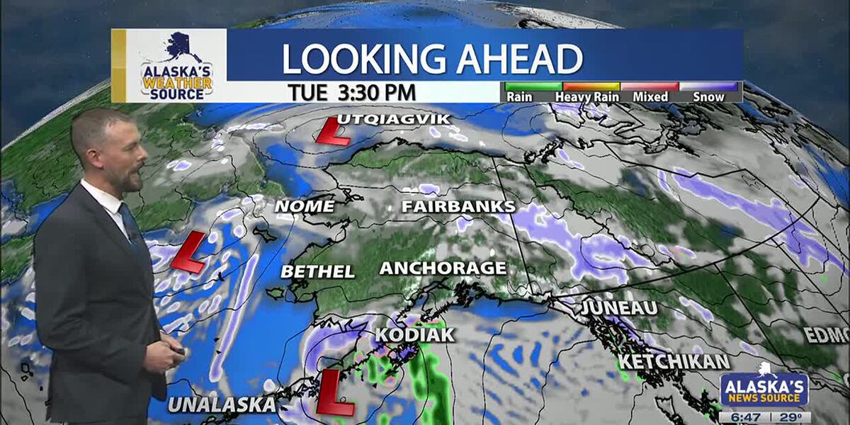
ANCHORAGE, Alaska (KTUU) – Temperatures across the state are cooling off, as our strong low from the weekend moves into the Chukchi Sea. This will set up for colder air to spread across the state this week, as another short-lived cold snap is expected. While some light snow is possible for the Interior, areas of the Slope and Western Alaska, Southcentral will stay on the drier side until the night. Meanwhile, Southeast will continue to hold onto moderate rain with gusty conditions.

SOUTHCENTRAL:

Temperatures this morning are 10 to 20 degrees colder than yesterday, as colder air has settled back into Southcentral. Clear skies and calm winds are evident this morning for parts of the region, with light snow falling through the Copper River Basin. We’ll see fairly quiet conditions today, outside of Kodiak which will see increasing snow and rain into the afternoon and evening hours. This comes as our next area of low pressure moves up the Alaska Peninsula.

We’ll see light snow spreading north across the Kenai overnight into Wednesday, with light snow expected through Prince William Sound. Several inches are likely through the Kenai and Chugach Mountains, with the pass expected to see a couple of inches of accumulation. Western parts of the Kenai will see the potential for a few inches, while inland areas of Southcentral largely stay dry. If Anchorage and surrounding locations see any accumulation, it’ll amount to less than half an inch.

Advertisement

As snow tapers off Wednesday, we’ll see the return to colder and drier conditions into Thursday. Thursday may be the coldest day this week across the region, before another warming trend carries us into next week. Right now holding with snow through early next week, but areas of wintry mix are possible as highs warm above freezing.

SOUTHEAST:

The winter storm warning for Skagway and higher elevations expired at 6am this morning. While some light snow showers are still possible, little accumulation will occur the rest of the day. Scattered to periodic showers are occurring elsewhere across Southeast today, with less than half an inch of rainfall through the day. Any moisture available into the evening will see a transition to some wintry mix or snow into Wednesday morning. However, the better chance will come from another low lifting north into the panhandle. Any snow and wintry mix we see for Wednesday will primarily stay confined to the central and southern panhandle. We’ll see much cooler weather taking hold this week for Southeast.

INTERIOR:

Some areas of light snow are possible this morning, with less than half an inch to be expected. While temperatures are still warm for much of the Interior, highs will steadily fall throughout the day. Many areas will see lows bottom out near or below zero by tomorrow morning. We’ll see high pressure keep things dry and sunny through the next couple of days, with the coldest stretch of weather from Wednesday morning into Thursday morning. Much like the rest of the state will experience, a warming trend arrives this weekend. We’ll see the return to highs in the 20s, with some snow in the forecast. Be prepared for some gusty conditions through the Alaska Range by the close of this week.

Advertisement

SLOPE/WESTERN ALASKA:

Areas of light snow and blowing winds will continue to impact the Slope, with a winter weather advisory remaining in place for the Central Brooks Range and the Beaufort Sea Coast. Both locations will see up to 1 inch of snow and gusty winds up to 35 mph. While the winter weather advisory will expire for the Central Brooks Range this afternoon, the Beaufort Sea Coast will see the alert continue into Tuesday evening. Snow and blowing snow will be the primary impact today, with a return to colder weather through the rest of this week, this comes as high pressure settles into the area.

The storm responsible for the damaging winds for Southcentral over the weekend, has pushed north into the Chukchi Sea. We’ll still see some light snow accumulations for Western Alaska, with 1 to 3 inches expected. Some fo the heaviest snow will fall across the Seward Peninsula and the Western Brooks Range.

An area of low pressure in the Bering Sea will keep gusty winds and snow in the forecast for Gambell/St. Lawrence. Be prepared for heavy snow at times and areas of reduced visibility. Overall, colder weather will settle into Western Alaska, with the possibility of morning fog in the valleys over the next few mornings.

ALEUTIANS:

Advertisement

Some light areas of snow will occur for the Pribilof Islands and into parts of the Alaska Peninsula today, as a weak low moves up the Peninsula. This will be the main focus for snow into Wednesday for Southcentral. This low will bring heavy precipitation and gusty winds for the Eastern Aleutians and the Alaska Peninsula. Looking ahead through the rest of the week, we can expect to see more a ridge beginning to build into the region. This ridge will slowly shift east, keeping several upper level disturbances traversing the Aleutians. Temperatures will remain fairly warm in the 30s and 40s.

OUTLOOK AHEAD:

Model consensus continues to agree on another warming trend heading our way into next week. This stretch of warmth will likely lead to many spots cementing themselves within the top warmest January’s on record. While we’ll spend the rest of this week on the colder side, highs steadily climb this weekend into next week. We’ll see highs in Southcentral climbing back above freezing, with areas of the Interior climbing back into the 20s.

Have a safe and wonderful Tuesday!

See a spelling or grammar error? Report it to web@ktuu.com

Advertisement


Source link

Continue Reading
Advertisement

Trending