Connect with us

Alaska

On a beautiful weekend in Southeast Alaska, attractive hiking options abound

Published

on

On a beautiful weekend in Southeast Alaska, attractive hiking options abound


I didn’t plan on going to Southeast Alaska to find some great weather, but last week I hit the jackpot in Juneau and Ketchikan.

After our damp-and-dreary Anchorage summer, I rejoiced when the sun came out in Juneau.

Cruise season has slowed a bit, but there still are lots of ships cruising the Inside Passage. In fact, there are cruise ships scheduled well into October this year. That means more options for travelers who want to go on guided tours in the air or on the water.

Advertisement

But on a bright sunny day, I pulled on my boots, looking for a scenic hike to get some million-dollar views.

In Juneau, one of my favorite hikes is up the Mount Roberts Trail.

The trail is easy to access on two fronts: from Basin Road, which is just uphill a couple of blocks from the Alaska State Capitol, or from the Goldbelt Tram, which leaves from the cruise ship docks.

Friends tell me the hike up from Basin Road is challenging. Trail maps say it’s a six-hour hike. I took the tram, which covered quite a bit of the vertical gain, in about five minutes.

It’s a quick 1-mile walk up to Father Brown’s Cross, named after a priest who helped build the trail in 1908. Along the way there are several vistas that afford fabulous views of Gastineau Channel in both directions.

Advertisement

You can continue up to Mount Roberts (and beyond). It’s a spectacular hike.

From the trailhead on Basin Road, there are several other trails you can take, including the Perseverance Trail. The trail is a little less than 5 miles up and back. I haven’t hiked it, but hear good reports.

The other hike, right across from the Mount Roberts trailhead, is the Gold Creek Flume Trail. This is an easy hike along over a man-made flume, which powered Juneau’s first hydroelectric project. It’s just a mile and a half there and back, but there are lots of bridges over the rushing water and the trail is well-maintained. It’s a popular lunchtime stroll right up the hill from downtown Juneau.

Out past the airport in Juneau is the Mendenhall Valley, formed by the Mendenhall Glacier. The visitor center is an easy 13-mile drive from downtown Juneau. There are some great views of the glacier in and around the visitor center.

But you just can’t miss Nugget Falls. It’s at least 100 feet tall and the water thunders down nonstop to Mendenhall Lake. It’s loud! The trail from the visitor center is almost flat — and it’s about a mile and a half round-trip. Get up close the falls and feel the spray. Walk to the end of the spit in front of the falls for some good photos.

Advertisement

The other hike on my list isn’t very long, but it’s a beautiful setting. The Shrine of St. Therese is a retreat center run by the Catholic Church. It’s a 22-mile drive north from downtown Juneau, right on the water.

There are two separate beaches at the site. You can see several cabins that are used for retreats set back a bit from the beach. There’s a causeway that leads to “Shrine Island,” where there is a stone chapel in the trees.

There’s a trail around the island that includes several striking vistas where you can look out onto the Gastineau Channel. Often, you can see humpback whales feeding in the distance. Accordingly, it’s not unusual to see a fleet of sightseeing boats watching for another breaching whale.

Both Juneau and Ketchikan are in the Tongass National Forest — and there are dozens of hiking trails for hikers of all abilities. Learn more at the Tongass National Forest website.

When I arrived in Ketchikan, the weather was typical: rain. There’s just one nonstop flight from Juneau to Ketchikan, Alaska Air flight 60, arriving at 8:10 a.m. I still was a little sleepy. But the ferry ride from the airport to town offered a healthy dose of salt spray and a stiff north wind. After the five-minute ride, I was wide awake.

Advertisement

The next morning, the sky was blue and the sun was out. If you’re staying downtown in Ketchikan, there’s one trail that starts on historic Creek Street.

Creek Street once was Ketchikan’s red-light district, so the trail originally was well-trodden by the married customers trying to discreetly visit the “bawdy houses” along the creek.

Today, Creek Street is a collection of shops and galleries. The trail goes right by the front doors, before weaving over the creek and up the hill to the Cape Fox Lodge, which overlooks the downtown area.

[Changes to airline reward programs are making it tougher to collect perks. But travelers can still find rewards.]

Instead of heading up the hill to the lodge, I opted for a beautiful hike along Ketchikan Creek.

Advertisement

“My favorite hike is from Creek Street up to the Totem Heritage Center,” said Kara Tetly, executive director of the Ketchikan Visitors Bureau. Along the way you’re likely to see gobs of spawning salmon. There was a hatchery on the creek that’s now closed, but there’s still a healthy salmon run up the creek.

Tetley and I also compared notes on another popular Ketchikan hike: the Rainbird Trail. The trail is up above the downtown district, with an entrance near the University of Alaska Southeast campus. It’s a 45-minute walk one way through the rain forest. Even if it’s sunny, you’ll be happy you wore your boots. It’s soggy, after all, in the rain forest. Be prepared for some million-dollar views.

Neither Tetley nor I have been on the big hike that’s popular with cruise ship visitors. That’s the trek up to Deer Mountain. “You really should take a cab up to the trailhead,” said Tetley, unless you rented a car.

You can start your trek to Deer Mountain from downtown if you wish. Just follow the signs on Ketchikan Lakes Road to the dump. The trailhead is across the street.

“Yes, it’s best to take a taxi to the trailhead,” said Michael Briggs, general manager of the Cape Fox Lodge. “You’ve still got three and a half miles to go, plus a 2,000-foot climb.”

Advertisement

If it’s raining when you arrive in Juneau or Ketchikan, head to the museums.

At the Alaska State Museum in Juneau, there’s a special exhibit on Alaska Native gut knowledge and perseverance. Called “Visceral: Verity Legacy Identity,” the exhibit features traditional and modern displays of animal gut for art and apparel.

In Ketchikan at the Tongass Historical Museum, check out Ray Troll’s “Fossil Coastline” exhibit.


Source link

Advertisement
Continue Reading
Advertisement
Click to comment

Leave a Reply

Your email address will not be published. Required fields are marked *

This site uses Akismet to reduce spam. Learn how your comment data is processed.

Alaska

Sky Watch Alaska: planets align plus the aurora forecast

Published

on

Sky Watch Alaska: planets align plus the aurora forecast


ANCHORAGE, Alaska (KTUU) – This is a great time of year to do some star gazing. If you have clear skies in your part of Alaska, take the time to check out the night — and morning — sky.

After sunset, look toward the southwest. Saturn and Venus are snuggled up together (of course, they are more than 800 million miles apart) in the evening sky. They set at about 9:40 p.m. in Southcentral.

Before 9:40 p.m., you can see four planets with the naked eye — Saturn, Venus, Jupiter and Mars. Jupiter and Mars stick around through the morning. Mars is very close to the moon right now.

The Aurora forecast is fairly weak for the next few weeks. That’s not to say there won’t be the occasional burst but overall, solar activity is expected to be fairly low until the beginning of February.

Advertisement

If you get great pictures of the planets, the sky, or the aurora, don’t forget to send them to Alaska’s News Source.

See a spelling or grammar error? Report it to web@ktuu.com


Source link

Advertisement
Continue Reading

Alaska

Short-lived cold snap, with another warming trend this weekend

Published

on

Short-lived cold snap, with another warming trend this weekend


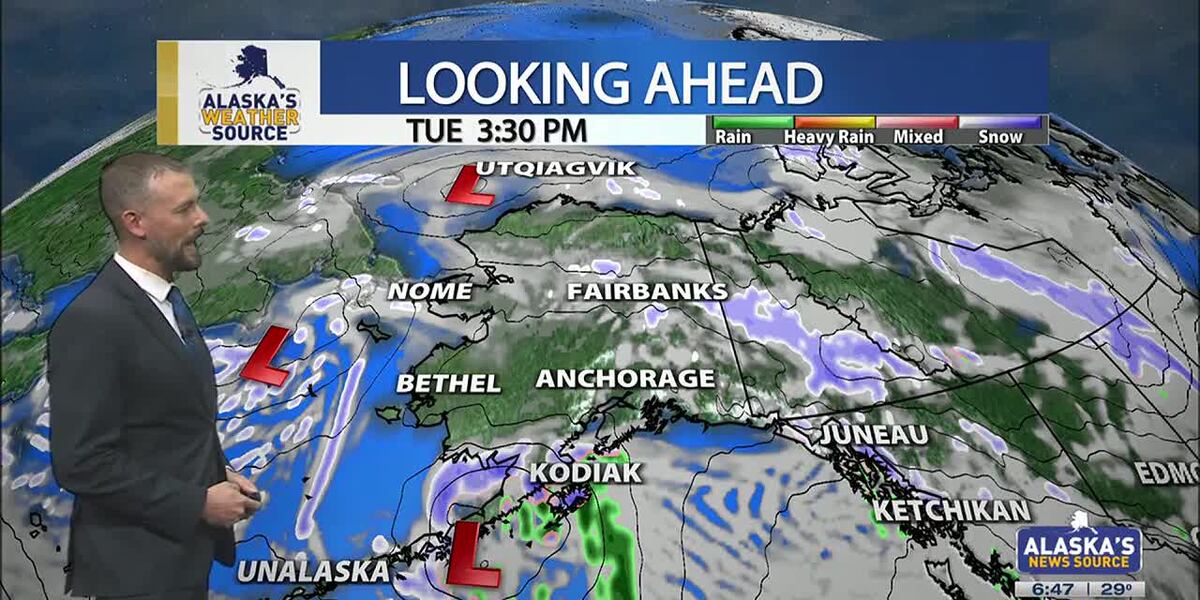
ANCHORAGE, Alaska (KTUU) – Temperatures across the state are cooling off, as our strong low from the weekend moves into the Chukchi Sea. This will set up for colder air to spread across the state this week, as another short-lived cold snap is expected. While some light snow is possible for the Interior, areas of the Slope and Western Alaska, Southcentral will stay on the drier side until the night. Meanwhile, Southeast will continue to hold onto moderate rain with gusty conditions.

SOUTHCENTRAL:

Temperatures this morning are 10 to 20 degrees colder than yesterday, as colder air has settled back into Southcentral. Clear skies and calm winds are evident this morning for parts of the region, with light snow falling through the Copper River Basin. We’ll see fairly quiet conditions today, outside of Kodiak which will see increasing snow and rain into the afternoon and evening hours. This comes as our next area of low pressure moves up the Alaska Peninsula.

We’ll see light snow spreading north across the Kenai overnight into Wednesday, with light snow expected through Prince William Sound. Several inches are likely through the Kenai and Chugach Mountains, with the pass expected to see a couple of inches of accumulation. Western parts of the Kenai will see the potential for a few inches, while inland areas of Southcentral largely stay dry. If Anchorage and surrounding locations see any accumulation, it’ll amount to less than half an inch.

Advertisement

As snow tapers off Wednesday, we’ll see the return to colder and drier conditions into Thursday. Thursday may be the coldest day this week across the region, before another warming trend carries us into next week. Right now holding with snow through early next week, but areas of wintry mix are possible as highs warm above freezing.

SOUTHEAST:

The winter storm warning for Skagway and higher elevations expired at 6am this morning. While some light snow showers are still possible, little accumulation will occur the rest of the day. Scattered to periodic showers are occurring elsewhere across Southeast today, with less than half an inch of rainfall through the day. Any moisture available into the evening will see a transition to some wintry mix or snow into Wednesday morning. However, the better chance will come from another low lifting north into the panhandle. Any snow and wintry mix we see for Wednesday will primarily stay confined to the central and southern panhandle. We’ll see much cooler weather taking hold this week for Southeast.

INTERIOR:

Some areas of light snow are possible this morning, with less than half an inch to be expected. While temperatures are still warm for much of the Interior, highs will steadily fall throughout the day. Many areas will see lows bottom out near or below zero by tomorrow morning. We’ll see high pressure keep things dry and sunny through the next couple of days, with the coldest stretch of weather from Wednesday morning into Thursday morning. Much like the rest of the state will experience, a warming trend arrives this weekend. We’ll see the return to highs in the 20s, with some snow in the forecast. Be prepared for some gusty conditions through the Alaska Range by the close of this week.

Advertisement

SLOPE/WESTERN ALASKA:

Areas of light snow and blowing winds will continue to impact the Slope, with a winter weather advisory remaining in place for the Central Brooks Range and the Beaufort Sea Coast. Both locations will see up to 1 inch of snow and gusty winds up to 35 mph. While the winter weather advisory will expire for the Central Brooks Range this afternoon, the Beaufort Sea Coast will see the alert continue into Tuesday evening. Snow and blowing snow will be the primary impact today, with a return to colder weather through the rest of this week, this comes as high pressure settles into the area.

The storm responsible for the damaging winds for Southcentral over the weekend, has pushed north into the Chukchi Sea. We’ll still see some light snow accumulations for Western Alaska, with 1 to 3 inches expected. Some fo the heaviest snow will fall across the Seward Peninsula and the Western Brooks Range.

An area of low pressure in the Bering Sea will keep gusty winds and snow in the forecast for Gambell/St. Lawrence. Be prepared for heavy snow at times and areas of reduced visibility. Overall, colder weather will settle into Western Alaska, with the possibility of morning fog in the valleys over the next few mornings.

ALEUTIANS:

Advertisement

Some light areas of snow will occur for the Pribilof Islands and into parts of the Alaska Peninsula today, as a weak low moves up the Peninsula. This will be the main focus for snow into Wednesday for Southcentral. This low will bring heavy precipitation and gusty winds for the Eastern Aleutians and the Alaska Peninsula. Looking ahead through the rest of the week, we can expect to see more a ridge beginning to build into the region. This ridge will slowly shift east, keeping several upper level disturbances traversing the Aleutians. Temperatures will remain fairly warm in the 30s and 40s.

OUTLOOK AHEAD:

Model consensus continues to agree on another warming trend heading our way into next week. This stretch of warmth will likely lead to many spots cementing themselves within the top warmest January’s on record. While we’ll spend the rest of this week on the colder side, highs steadily climb this weekend into next week. We’ll see highs in Southcentral climbing back above freezing, with areas of the Interior climbing back into the 20s.

Have a safe and wonderful Tuesday!

See a spelling or grammar error? Report it to web@ktuu.com

Advertisement


Source link

Continue Reading

Alaska

Anchorage, Alaska hit by hurricane-force winds, structures damaged across city

Published

on

Anchorage, Alaska hit by hurricane-force winds, structures damaged across city


Associated Press

Hurricane-force winds cause widespread damage in Alaska’s largest city

Thousands of residents across Alaska’s largest city were still without power Monday, a day after a powerful storm brought hurricane-force winds that downed power lines, damaged trees, forced more than a dozen planes to divert, and caused a pedestrian bridge over a highway to partially collapse. A 132-mph (212-kph) wind gust was recorded at a mountain weather station south of Anchorage. A large low-pressure system in the Bering Sea brought the high winds, moisture and warmer than average temperatures — in the low 40s Fahrenheit (slightly over 4.4 degrees Celsius) — to Anchorage on Sunday, said National Weather Service meteorologist Tracen Knopp.


Source link

Continue Reading

Trending