* Winter weather advisory through 7 a.m. Tuesday *
Washington, D.C
Updates: Light accumulation and slick this morning, with heavier snow by evening

In and around the Beltway, totals are mostly under half an inch so far, with around an inch observed in places such as Herndon, Manassas and Broad Run.
Snowflakes may continue to flutter a good chunk of the day without accomplishing more than a dusting to a few tenths of an inch on top of what has fallen. Light rates and what little sun rays make it through the clouds help keep snow from adding up, even with cold temperatures.
It is still quite cold — mostly mid-20s across the area, with some upper 20s toward southern Md. Given the cold conditions, any melting will also be minimal.
Even downtown and places south or east, temperatures likely only briefly flirt with freezing this afternoon, with readings falling back into the 20s before or around sunset. Periods of moderate and perhaps briefly heavy snow become more likely this afternoon and heading into evening, when a few inches can fall.
7:00 a.m. update – Minor accumulation early morning, numerous slick spots
Snow in the area this morning has mainly been of the very light variety. Cold temperatures ranging across the 20s have allowed it all to stick, causing rather widespread slick spots on roadways and sidewalks. Untreated spots and lesser-traveled side roads are reported to be particularly slippery.
For the most part, it’s been a dusting to a third of a half inch of snow across the pre-dawn hours. Not a lot — just enough to cause issues.
We should see lulls intermixed with light snow until it picks up in intensity this afternoon and evening. Most of the snow will fall this evening. Additional snowfall accumulation during the day is likely minor, mainly on untreated roads and sidewalks or on grassy and elevated surfaces.
With temperatures struggling to get past freezing this afternoon, any heavier bursts that do occur can accumulate more readily. And once the sun starts going down again, ice risks increase into the night.
A somewhat subjective rating of the day’s weather, on a scale of 0 to 10.
5/10: Right in the middle. An average of those who like snow and those who don’t.
- Today: Some light snow early. Steadier snow develops in afternoon. Highs: Upper 20s to mid-30s.
- Tonight: Periods of snow. Lows: Mid-20s to around 30.
- Tomorrow: Some light snow or freezing rain, mainly early. Highs: Near 30 to mid-30s.
It’s been almost two years to the day (tomorrow) since we last saw an inch of snowfall in Washington in a calendar day. We seem about to end that drought — the second longest on record — with the potential for a couple inches or so through Tuesday. Freezing air will ensure that slick road conditions develop as snow increases from tonight into early Tuesday. Then it stays cold, ensuring the snow sticks around. Not only that, there could also be some more Friday.
Today (Monday): A little snow produces a quick coating early in the day. With temperatures in the low and mid-20s, slippery roads are a risk. Thereafter, snow may pause or become rather intermittent before perhaps increasing in the early afternoon. Any light snow during the day before midafternoon may not stick well to roads as temperatures climb into the low 30s. But, especially as snow becomes steadier later in the afternoon and temperatures fall when darkness approaches, more will stick to more surfaces. Winds are from the southeast around 5 to 10 mph. Confidence: Medium-High
Tonight: Snow intensity should pick up heading into evening, and roads could well become icy area-wide. Snow could be moderate at times for a few hours through about midnight before easing into the pre-dawn hours. By that point, 1 to 3 or 2 to 4 inches of snow should be common. The snow could switch to a little freezing rain toward dawn, especially from the District and to the south and east. Lows range from 25 to 30. Confidence: Medium
Follow us on Facebook, Twitter, and Instagram for the latest weather updates. Keep reading for the forecast through the weekend…
Tomorrow (Tuesday): Snow or mixed precipitation is possible early, and untreated roads will be slick; expect school delays and cancellations. But we should start to dry out later in the morning or by around midday, and little additional snow accumulation is expected. Highs range from the low to mid-30s, from northwest to southeast. Winds pick up out of the northwest with time. Confidence: Medium
Tomorrow night: There may be an evening flurry, but skies should be trending clearer through the night. It’s the coldest night of the season so far, with lows ranging across the teens. Confidence: Medium-High
The sun is back on Wednesday, but it’s cold. Highs range from about 30 to the low 30s, helping keep snow and ice around. Lows Wednesday night are in the teens and low 20s. Confidence: Medium
It turns cloudier Thursday as the next chance of wintry weather approaches. Highs reach the mid-30s or so. Some light snow could develop at night. Confidence: Medium
Another weak storm system passes by the area Friday. It could produce another round of light snow, with highs in the low to mid-30s. Confidence: Low-Medium
A reinforcing shot of cold air is on tap for the weekend. Highs may get stuck in the 20s to low 30s Saturday as winds again gust from the northwest, and a flurry is possible. They moderate to 30 to 35 by Sunday with sunshine still sticking around. Confidence: Medium
A daily assessment of the potential for at least 1 inch of snow in the next week, on a 0-10 scale.
8/10 (↑): Snowflakes that start Monday morning could add up to a couple inches or so, especially into tonight. Seems the snow drought is going to break. Maybe some more Friday.

Washington, D.C
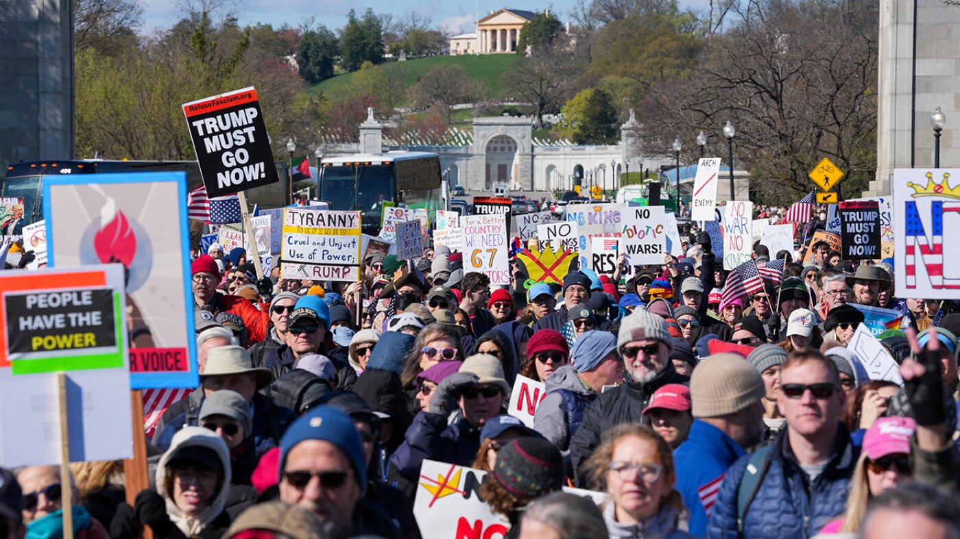
Thousands turn out – again – as third 'No Kings' rallies take over Maryland streets

Washington, D.C
WATCH LIVE: No Kings march and rally in DC

WASHINGTON – Thousands are expected gather in Washington, D.C. for a “No Kings” march and rally.
Here’s everything you need to know:
What is the No Kings protest?
What we know:
Organized locally by area chapters of Indivisible and allied grassroots groups, the event aims to draw protesters to downtown Washington and surrounding counties to oppose policies of the Trump administration and to voice broader concerns about civil rights and democratic norms.
No Kings protest details
Timeline:
The march will kick off at 10 a.m., with participants gathering at Memorial Circle near Arlington Cemetery, with additional access from the Blue Line or nearby parking at the Fashion Centre at Pentagon City, according to the event organizers. There is no public parking in the immediate area, but participants can be dropped off at the circle.
From there, the procession will head across the Memorial Bridge into Washington, D.C., passing the Lincoln Memorial and continuing on to the Washington Monument.
At the conclusion of the march, participants can walk to a downtown rally, from 1:30 p.m. to 4 p.m.
Other ‘No Kings’ rallies in the DMV
Dig deeper:
In addition to the main rally in downtown D.C., several other demonstrations tied to “No Kings 3” are scheduled around the DMV this Saturday.
In Arlington, Virginia, activists are organizing a march across the Memorial Bridge beginning at 10 a.m., with protesters expected to continue into West Potomac Park before joining larger crowds in the District proper, for example.
There are hundreds of “No Kings” events scheduled to take place this Saturday throughout the DMV. You can click here to find a list of all of them.
How to watch No Kings march and rally in DC
What you can do:
FOX 5 DC will be covering No Kings in D.C. all day on FOX LOCAL and in the liveplayer at the top of this story.
FOX 5 DC is available to watch for free on Roku, Amazon FireTV, Apple TV, Google Android TV and Vizio with the FOX LOCAL app. Here’s how to download FOX LOCAL on your mobile phone.
Washington, D.C
‘Strong smell’ shuts down flights at major DC-area airports for the second time this month

Check out what’s clicking on FoxBusiness.com.
A reported “strong smell” at a key air traffic control center disrupted flights Friday evening at major airports across the Washington, D.C., region for the second time in two weeks.
The Federal Aviation Administration (FAA) temporarily halted flights at Ronald Reagan Washington National Airport (DCA), Washington Dulles International Airport (IAD), Baltimore/Washington International Airport (BWI), Charlottesville–Albemarle Airport (CHO) and Richmond International Airport (RIC), the agency told FOX Business in an email.
The FAA said the disruptions were due to a “strong smell” at the Potomac Terminal Radar Approach Control (TRACON) center, which manages airspace in the region.
GROUND STOP LIFTED AT MAJOR DC-AREA AIRPORTS AFTER CHEMICAL ODOR DISRUPTS AIR TRAFFIC CONTROL
An FAA air traffic control tower at Ronald Reagan Washington National Airport in Arlington, Va. (Samuel Corum/Bloomberg via Getty Images / Getty Images)
It was not immediately clear what caused the smell.
Ground stops at Dulles, Reagan National and BWI remained in effect until around 8 p.m. ET before being lifted, according to the FAA’s website.
NEWARK AIR TRAFFIC CONTROLLERS LOST RADAR, RADIO COMMUNICATIONS WITH PLANES FOR OVER A MINUTE, SPARKING CHAOS
The FAA said the disruption was due to a “strong smell” at the Potomac Terminal Radar Approach Control (TRACON) center. (Flightradar24)
As of 8:30 p.m., Reagan National was experiencing ground delays, while BWI continued to see departure delays.
Earlier this month, a ground stop was similarly issued at several airports in the Washington, D.C., region after a chemical odor was detected at the TRACON center.
FATAL LAGUARDIA COLLISION RENEWS FOCUS ON RUNWAY INCURSION RISKS ACROSS US
Transportation Secretary Sean P. Duffy speaks at a news conference at Ronald Reagan Washington National Airport. (Heather Diehl/Getty Images / Getty Images)
GET FOX BUSINESS ON THE GO BY CLICKING HERE
The temporary ground stop March 13 similarly affected DCA, IAD, BWI and RIC, Transportation Secretary Sean Duffy said at the time.
Duffy said the smell came from an overheated circuit board, which has since been replaced.
-

 Sports1 week ago
IOC addresses execution of 19-year-old Iranian wrestler Saleh Mohammadi
-

 New Mexico7 days ago
Clovis shooting leaves one dead, four injured
-

 Tennessee6 days ago
Tennessee Police Investigating Alleged Assault Involving ‘Reacher’ Star Alan Ritchson
-

 Technology7 days ago
YouTube job scam text: How to spot it fast
-

 Minneapolis, MN3 days ago
Boy who shielded classmate during school shooting receives Medal of Honor
-

 Science1 week ago
Record Heat Meets a Major Snow Drought Across the West
-

 Politics1 week ago
Schumer gambit fails as DHS shutdown hits 36 days and airport lines grow
-

 Texas1 week ago
How to buy Houston vs. Texas A&M 2026 March Madness tickets


![~!@[WATCHLIVE!TV]>> NOW Portland Thorns FC vs Kansas City Current Match 𝐋𝐈𝐕𝐄 Free Streams ON Tv Channel ~!@[WATCHLIVE!TV]>> NOW Portland Thorns FC vs Kansas City Current Match 𝐋𝐈𝐕𝐄 Free Streams ON Tv Channel](https://i2.wp.com/unicornriot.ninja/wp-content/uploads/2018/09/LiveChannel334x212v2.png?w=400&resize=400,240&ssl=1)
![~!@[WATCHLIVE!TV]>> NOW Portland Thorns FC vs Kansas City Current Match 𝐋𝐈𝐕𝐄 Free Streams ON Tv Channel ~!@[WATCHLIVE!TV]>> NOW Portland Thorns FC vs Kansas City Current Match 𝐋𝐈𝐕𝐄 Free Streams ON Tv Channel](https://i2.wp.com/unicornriot.ninja/wp-content/uploads/2018/09/LiveChannel334x212v2.png?w=80&resize=80,80&ssl=1)


