News
Firefighters continue battling massive wildfire in California ahead of thunderstorms

A CL 415 scooper, top, drops water on the Quarry Fire as a Firehawk helicopter maneuvers for a water drop Thursday, Aug. 1, 2024, southwest of Littleton, Colo.
Andy Cross/AP/The Denver Post
hide caption
toggle caption
Andy Cross/AP/The Denver Post
CHICO, Calif. — Firefighters made progress Saturday against California’s largest wildfire of the year ahead of expected thunderstorms that could unleash fire-starting lightning and erratic winds and erode progress made over the past week. Dry, hot conditions posed similar threats across the fire-stricken West.
“We’re not completely out of the woods yet, but we’re looking very, very good,” CalFire official Mark Brunton said in a video update Saturday. “This is moving at a very fast pace.”
Containment of the Park Fire, now California’s fourth-largest wildfire on record, was at 27% as of Saturday afternoon. Brunton said the relatively milder weather the last few days allowed firefighters to build containment lines.
But hotter weather, fuels and terrain will continue posing challenges for the estimated 6,500 firefighters battling the fire, which has spread over 626 square miles (1,621 square kilometers) since allegedly being started by arson in a park in the Sierra Nevada foothills east of the Sacramento Valley city of Chico. For comparison, the city of Los Angeles covers about 503 square miles (1,302 square kilometers).
Suppression crews will also start removing damaged infrastructure in some areas Saturday. People living in the rural communities of Cohasset and Forest Ranch were told they could start returning home Saturday afternoon.
The fire originated at low elevations, where it quickly burned through thick grass and oaks, destroying at least 567 structures and damaging 51 so far. As it has climbed higher, the vegetation has changed to a greater concentration of trees and brush, Cal Fire said.
The fire’s push northward has brought it toward the rugged lava rock landscape surrounding Lassen Volcanic National Park, which has been closed because of the threat. The area remains one of the biggest challenges for firefighters, Cal Fire officials said Saturday afternoon. The smoke has also prevented firefighters from deploying helicopters and other aircrafts the last few days.
“There’s a lot of really steep drainages in that area,” CalFire spokesperson Devin Terrill said. “It takes a lot more time to access those areas.”
After a brief respite, firefighters are now bracing for treacherous conditions of hot and dry weather, along with expected thunderstorms with potential thunder strikes and gusty winds.
The collapse of thunderstorm clouds can blow wind in any and all directions, said Jonathan Pangburn, a fire behavior analyst with Cal Fire. “Even if there’s not lightning per se, it is very much a safety-watch-out environment for our firefighters out there,” Pangburn said.
The Park Fire is among almost 90 large fires burning across the western U.S. Evacuation orders were in effect for 22 of the fires, according to the National Interagency Fire Center.
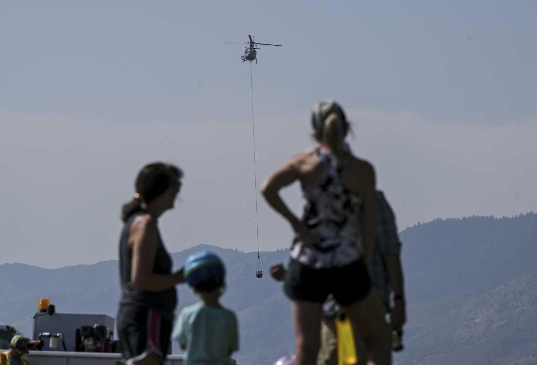
Onlookers watch while crews work near the Ken Caryl Ranch development as the Quarry fire burns Thursday, Aug. 1, 2024, southwest of Littleton, Colo.
AAron Ontiveroz/AP/The Denver Post
hide caption
toggle caption
AAron Ontiveroz/AP/The Denver Post
Crews made progress Saturday against three major fires burning in Colorado near heavily populated areas north and south of Denver, with containment figures improving and some evacuation orders lifted. One of the fires was being investigated as arson. About 50 structures had been damaged or destroyed, about half of them homes, and one person was found dead in a burned home earlier in the week.
The Jefferson County Sheriff’s Office is investigating a blaze threatening hundreds of homes near the Colorado city of Littleton as arson.
Karlyn Tilley, a spokesperson for Jefferson County Sheriff’s Office, said the investigation is ongoing, and investigators are using a dog specially trained to sniff out sources and causes of fires. Tilley said just because they suspect the fire was human-caused doesn’t mean it was intentional.
Firefighters were making good progress on the fire despite the steep, rocky terrain and blistering heat, and no houses had been burned, officials said.
The cause and origin of a fatal blaze west of the town of Lyons was being probed by the federal Bureau of Alcohol, Tobacco, Firearms and Explosives, with specially trained fire investigators from the agency helping local authorities, agency spokesperson Crystal McCoy said. The area blackened by that fire remained relatively unchanged after it burned five houses.
The largest of the Colorado fires, west of Loveland, grew to 14.9 square miles (38.5 square kilometers) after previously burning 49 homes and other structures. Its cause is under investigation.
Scientists say extreme wildfires are becoming more common and destructive in the U.S. West and other parts of the world as climate change warms the planet and droughts become more severe.


Note: Map shows the area with a shake intensity of 3 or greater, which U.S.G.S. defines as “weak,” though the earthquake may be felt outside the areas shown. The New York Times
A minor earthquake with a preliminary magnitude of 3.5 struck in Central California on Monday, according to the United States Geological Survey.
The temblor happened at 7:17 a.m. Pacific time about 6 miles northwest of Pinnacles, Calif., data from the agency shows.
As seismologists review available data, they may revise the earthquake’s reported magnitude. Additional information collected about the earthquake may also prompt U.S.G.S. scientists to update the shake-severity map.
Source: United States Geological Survey | Notes: Shaking categories are based on the Modified Mercalli Intensity scale. When aftershock data is available, the corresponding maps and charts include earthquakes within 100 miles and seven days of the initial quake. All times above are Pacific time. Shake data is as of Monday, March 2 at 10:20 a.m. Eastern. Aftershocks data is as of Monday, March 2 at 11:18 a.m. Eastern.

The U.S. and Israel have been conducting strikes against targets in Iran since Saturday morning, with the aim of toppling Tehran’s clerical regime. Iran has fired back, with retaliatory assaults featuring missiles and drones targeting several Gulf countries and American bases in the Middle East.
“All six aircrew ejected safely, have been safely recovered, and are in stable condition. Kuwait has acknowledged this incident, and we are grateful for the efforts of the Kuwaiti defense forces and their support in this ongoing operation,” Central Command said.
“The cause of the incident is under investigation. Additional information will be released as it becomes available,” it added.
In a separate statement later Monday, Central Command said that American forces had been killed during combat since the strikes began.
“As of 7:30 am ET, March 2, four U.S. service members have been killed in action. The fourth service member, who was seriously wounded during Iran’s initial attacks, eventually succumbed to their injuries,” it said.
Major combat operations continue and our response effort is ongoing. The identities of the fallen are being withheld until 24 hours after next of kin notification,” Central Command added.
This story has been updated.

Smoke rises over Konarak naval base in southern Iran on Sunday. The base was one of hundreds of targets of U.S. and Israeli forces throughout the country.
Planet Labs PBC
hide caption
toggle caption
Planet Labs PBC
Commercial satellite images are providing a unique look at the extent of damage being done to Iran’s military facilities across the country.
The U.S. and Israeli military campaign opened with a daytime attack that struck Iranian leadership in central Tehran. Smoke was still visible rising from Ayatollah Ali Khamenei’s compound following the attack that killed the supreme leader.

An image by the company Airbus taken on Saturday shows the aftermath of an Israeli strike on Iran’s Leadership House in central Tehran. Iran’s Supreme Leader Ayatollah Ali Khamenei was killed in the opening wave of attacks.
Pléiades Neo (c) Airbus DS 2026
hide caption
toggle caption
Pléiades Neo (c) Airbus DS 2026
Israel and the U.S. have gone on to strike targets across the country. Reports on social media indicate that there have been numerous military bases and compounds attacked all over Iran, and Iran has responded with attacks throughout the Middle East.
U.S. forces have also been striking at Iran’s navy. In a post on his social media platform, President Trump said that he had been briefed that U.S. forces had sunk nine Iranian naval vessels. U.S. Central Command did not immediately confirm that number but it did say it had struck an Iranian warship in port.

An image captured on Saturday shows a ship burning at Iran’s naval base at Konarak.
Satellite image ©2026 Vantor
hide caption
toggle caption
Satellite image ©2026 Vantor
Numerous satellite images show burning vessels at Konarak naval base in southern Iran. Images also show damage to a nearby airbase where hardened hangers were struck by precision munitions.

Hardened aircraft shelters at Konarak airbase were struck with precision munitions.
Satellite image ©2026 Vantor
hide caption
toggle caption
Satellite image ©2026 Vantor
And there was extensive damage at a drone base in the same area. Iran has launched numerous drones and missiles toward Israel and U.S. military installations in Bahrain, Kuwait and Qatar. Many drones have been intercepted but videos on social media show that some have evaded air defenses and caused damage in nearby Gulf countries. In Dubai, debris from an Iranian drone damaged the iconic Burj Al Arab, according to a statement from Dubai’s government.

Buildings at an Iranian drone base at Konarak were destroyed in the strikes.
Satellite image ©2026 Vantor
hide caption
toggle caption
Satellite image ©2026 Vantor
Iran’s most powerful weapons are its long-range missiles. The Iranian Revolutionary Guards have hidden the missiles deep inside mountain tunnels. Images taken Sunday in the mountains of northern Iran indicate that some of those tunnels were hit in a wave of strikes.
Following Khamenei’s death, Iran declared 40 days of mourning. Satellite images showed mourners gathering in Tehran’s Enghelab square on Sunday.
Iranian Foreign Ministry Spokesperson Esmail Baghaei told NPR on Sunday that Iran will continue to fight “foreign aggression, foreign domination.”
A White House official told NPR that Trump plans to talk to Iran’s interim leadership “eventually,” but that for now, U.S. operations continue in the region “unabated.”

A large crowd of mourners fill Enghelab Square in Tehran on Sunday, following the death of Iran’s Supreme Leader Ayatollah Ali Khamenei, who was killed in an Israeli airstrike.
Satellite image ©2026 Vantor
hide caption
toggle caption
Satellite image ©2026 Vantor

How South Dakota officials have reacted to ‘massive’ US attack on Iran

Volunteers needed for community-wide cleanup day with Hands On Nashville

Texas Tech student identified as victim in Austin bar shooting

Immigration agents bolster action at Utah courthouses, prompting criticism from some

Vermont high school playoff scores, results, stats for Monday, March 2

Florida High School Football Rankings: Top 25 teams – Oct. 21

Cleary's 21 help Le Moyne down Central Connecticut State 69-64 in OT

How old is Bo Nix? What to know about Oregon quarterback ahead of 2024 NFL Draft

99th annual Pony Swim held in Virginia

Indiana Members Credit Union announced as new anchor tenant at Bottleworks District
Map: Earthquake Shakes Central California

Gas prices could jump as Middle East tensions threaten global oil supply

Pakistan calls troops, orders 3-day curfew as 24 killed in pro-Iran rallies

US says Kuwait accidentally shot down 3 American jets

House Republicans push Johnson to go to war with Senate over SAVE Act
-

 World5 days ago
Exclusive: DeepSeek withholds latest AI model from US chipmakers including Nvidia, sources say
-

 Massachusetts5 days ago
Mother and daughter injured in Taunton house explosion
-

 Denver, CO5 days ago
10 acres charred, 5 injured in Thornton grass fire, evacuation orders lifted
-

 Louisiana1 week ago
Wildfire near Gum Swamp Road in Livingston Parish now under control; more than 200 acres burned
-

 Technology1 week ago
YouTube TV billing scam emails are hitting inboxes
-

 Politics1 week ago
OpenAI didn’t contact police despite employees flagging mass shooter’s concerning chatbot interactions: REPORT
-

 Technology1 week ago
Stellantis is in a crisis of its own making
-

 News1 week ago
World reacts as US top court limits Trump’s tariff powers