Indiana
Much of Indiana under winter storm watches for snow, sleet, freezing rain

INDIANAPOLIS (WISH) — A winter storm watch has been issued for much of central and southern Indiana from Saturday night into Monday night.
The bigger snowstorm will follow a smaller one expected to hit parts of Indiana on Thursday night and early Friday morning.
Here are details on the three separate winter storms watches, issued Thursday afternoon, that include Indiana.
Central Indiana
The National Weather Service at Indianapolis says to expect 6 inches of snow or more, with a potential accumulations of sleet and freezing rain around southern portions of central Indiana.
The storm was expected to bring slick and hazardous roadways, and snow on trees could bring down power lines.
The watch says, “Persons should consider delaying all travel. If travel is absolutely necessary, drive with extreme caution. Consider taking a winter storm kit along with you, including such items as tire chains, booster cables, flashlight, shovel, blankets and extra clothing. Also take water, a first aid kit, and anything else that would help you survive in case you become stranded.”
Indiana counties in the watch issued from the Indianapolis weather service office are Bartholomew, Boone, Brown, Carroll, Clinton, Clay, Daviess, Decatur, Delaware, Fountain, Greene, Hamilton, Hancock, Hendricks, Henry, Howard, Jackson, Jennings, Johnson, Knox, Lawrence, Madison, Marion, Martin, Monroe, Montgomery, Morgan, Owen, Parke, Putnam, Randolph, Rush, Shelby, Sullivan, Tippecanoe, Tipton, Vermillion, and Vigo.
Southeastern Indiana
The National Weather Service at Louisville, Kentucky, says to expect a wintry mix of snow, sleet, and freezing rain from late Saturday night through Monday afternoon. Snow and sleet amounts of greater than 4 inches and significant ice accumulations of greater than a quarter of an inch are expected in the watch area that includes southern Indiana.
Indiana counties in the watch area from the Louisville weather office are Clark, Crawford, Dubois, Floyd, Jefferson, Harrison, Orange, Perry, Scott, Washington. The watch from the Louisville weather officer also extends into Kentucky.
Southwestern Indiana
The National Weather Service at Paducah, Kentucky, says heavy mixed precipitation is possible from late Saturday night into late Sunday night. Snow and sleet accumulations of 4 inches or more, and ice accumulations of one-quarter inch or more are possible.
Indiana counties in the watch area from the Paducah weather office are Gibson, Pike, Posey, Spencer, Vanderburgh, and Warrick. The watch also includes parts of Illinois and Kentucky.
Statement
“The Indianapolis Department of Public Works (Indy DPW) is prepared for the forecasted winter weather conditions, including a strong winter system this weekend. Starting tonight, Indy DPW will dispatch over 80 crew members to begin pre-treating roadways, bridges, and overpasses across Marion County for a snow event set to start later this evening. Indy DPW crews will operate on rotating 12-hour shifts throughout the snow event, which Indy DPW officials expect to bring up to an inch of snowfall with potential freezing overnight.
“‘Our crews are prepared to address the weather expected to impact our community this week and will continue to monitor and respond to any changes in the forecast’ said Indy DPW Interim Director Sam Beres. ‘In partnership with AFSCME Local 725, we will remain focused on addressing roadway conditions throughout the duration of the expected weather impacts. We remind residents to give our snowplow and salt truck drivers space to work safely.’
“Looking ahead to the weekend, several weather models show the potential for a strong winter system (Sunday AM through Monday AM) that is expected to impact several Midwestern states, including Indiana. While it is too soon to determine the exact track of the system and snowfall totals at this time, Indy DPW is preparing for the possibility of hazardous conditions and significant travel impacts.
“Indy DPW reminds drivers to follow best practices when traveling in winter weather including:
- Staying informed: Before leaving home, find out about the road conditions. Drivers need to know the weather and their limits. Follow the National Weather Service (NWS) and local media to help you stay on top of the latest conditions and forecasts.
- Time and space: Leave plenty of time to reach your destination safely. Remember to drive below the posted speed limit and leave plenty of room between cars and Indy DPW vehicles. Always watch out for pedestrians.
- Pack extra resources: Stock your vehicle with extra resources that may be useful. Some resources include water, blankets, chargers for devices, extra clothes, and salt.
“Indianapolis constituents can stay up to date on winter weather events online by following us on Twitter @IndySnowForce and @IndyDPW. The Indy Snow Force Viewer will also be activated for this winter weather event, identifying roads located along standard routes that have been recently plowed or treated with salt during a snow event.
“For more information, please visit the Indy DPW Snow Force webpage at: indy.gov/snow“
Indianapolis Department of Public Works


INDIANAPOLIS — Hundreds of Hoosiers gathered at the Indiana Statehouse Saturday morning as part of nationwide ‘No Kings’ events to voice their concerns about the current administration.
WATCH FULL STORY BELOW
Hundreds gather at Indiana State Capitol for ‘No Kings’ protest
“I’m out here today because what’s happening in our government is completely trash,” Donna Sipes told WRTV. “It’s wrong. We need to do something about it.”
“I’m tired of every single day when the TV comes on to see what stupid thing he’s done next,” Lindi Marti said.
WRTV
Attendees noted the growing popularity of the demonstrations.
“This is my fourth one to come to. I didn’t come to all of them when it was really cold, but I’m glad to see that they are getting a lot more people out here every time,” Marti added. “It seems like there’s more and more coming.”
Demonstrators highlighted specific foreign policy concerns, including the administration’s handling of the war in Iran.
“We’re bombing the heck out of them. We’re killing civilians,” Marti’s husband said. “We’re getting ready to send our Marines.”
WRTV

Others focused on the administration’s handling of immigration.
“That’s what I’m concerned about,” Reverend Kenny Little told WRTV. “Little kids, they’re taking them away from their family. And I’m just one of those people, I think everyone got rights.”
Indiana medical students also attended the rally to speak out against changes to the healthcare system.
“We’re really worried about the attacks on the health care system in general, but with Medicaid… current estimates range from anywhere from 325,000 to 450,000 Hoosiers will lose coverage by 2032,” Wade Catt said with concern.
WRTV
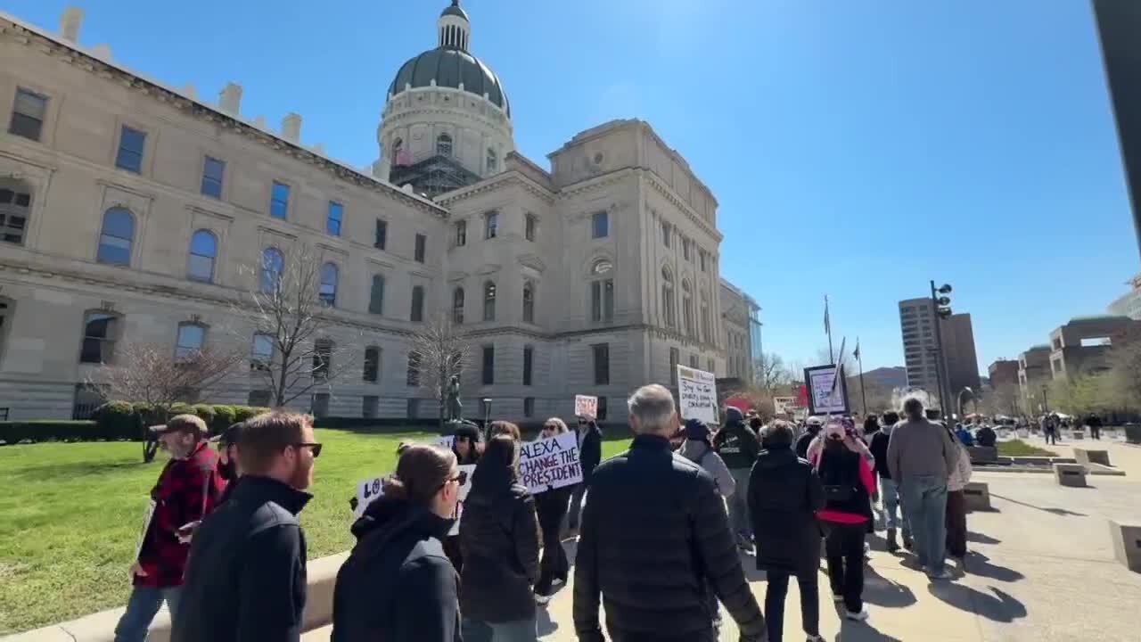
With midterm elections approaching later this year, attendees emphasized the importance of now taking action at the ballot box.
“If we don’t vote, then things are gonna not, they’re gonna stay the same,” a protester said.
Meanwhile, Indiana Lieutenant Governor Micah Beckwith says he’s happy to see Hoosiers exercise their First Amendment right to protest.
However, he takes issue with the idea that President Trump is acting like a king. Beckwith says the fact that people have the freedom to protest is proof that the president is not acting like a tyrant.
He acknowledges that bridging the gap between the sides is probably an uphill battle, but believes communication is key.
“I think when you sit down with people face to face, you’re confronted with humanity. There’s another human sitting across that table from you and talking to you. And so, all I have to say, I think that’s probably the thing I would encourage all Hoosiers to do is say, ‘Hey, if you don’t agree with somebody or if you don’t like somebody, why don’t you try grabbing coffee with them? And give it 30 minutes, and just see what happens.’ I bet most of the time people will walk away with a much softer heart and spirit towards that person before they came in,” Beckwith said.
Beckwith is currently on a 92-county tour of the state. He says all sides are welcome to attend his events.
__

INDIANAPOLIS (WISH) — Police say one “young man” is dead after a shooting at the 1200 block of Rue Rabelais at about 7:19 p.m. according to the Indianapolis Metropolitan Police Department.
That is near the intersection of 56th Street and Binford Boulevard.
Police say the victim was taken to Riley Hospital where he later died. Investigators say they are still working to identify the victim.
There was no known information about a suspect. Police did say that they believe this is a targeted incident.
There was no other information immediately available.
This story has been updated with information from the Indianapolis Metropolitan Police Department.

This story contains descriptions of distressing circumstances involving children.
INDIANAPOLIS (WISH) – A mother and her boyfriend were accused of causing the death of a 4-year-old-boy found dead in a basement closet on Monday.
Indianapolis Metropolitan Police Department arrested Angel Lovely, 37, and Nicholas Bergdoll, 36, on preliminary charges of neglect of a dependent causing death. The Marion County Prosecutor’s Office by Friday had not filed formal charges.
A sibling found the 4-year-old dead on Monday, according to investigators. Lovely and Bergdoll were in the home at the time but told police they were asleep when he died.
Born premature with cerebral palsy, the 4-year old couldn’t walk, was nonverbal, and ate through a feeding tube. Lovely claimed she would rarely put the child in the closet, only “when he won’t stop screaming” or when she “needed a break.”
But when investigators interviewed Lovely’s three other children, they said that the boy “stays in the closet all day,” and that “mom locks him in the closet” and “does not pay attention to him.”
An exact cause of death hasn’t been determined, but the child was found with blood in his mouth. Lovely said he’d been aspirating.
One of Lovely’s children told investigators they heard the 4-year-old gagging but didn’t say anything because it wasn’t unusual.
A neighbor living on Monticello Drive, Michelle Johnson, told News 8, “It’s horrible. It breaks my heart.”
Johnson had seen the other children outside the home but never knew there was a boy in a wheelchair living there. She said if she suspected they were being neglected, she would have called police or the Indiana Department of Child Services.
“We’re supposed to be a village and raise kids together,” Johnson said. “That’s really heartbreaking.”
Bergdoll told police, according to the investigators’ report, that he didn’t agree with putting the child in the closet: “I am not going to tell her how to f****** raise her kids.”
“I’m sickened,” IMPD Public Information Officer Tommy Thompson told News 8 in an interview.
“Think about putting yourself in that situation. Every day, do you want to be in a closet? Locked up, no light?”
Court records show the Department of Child Services had removed the boy from Lovely’s care because of medical neglect, but she regained custody last year against DCS recommendations.
Thompson, the neighbor, hopes the tragedy can be an opportunity for others to speak up when they see a child who can’t speak up for themselves. “Maybe you’ve got to make that tough phone call. Reach out. The city has resources.”
Johnson wishes she would have known what was happening so she could have said something. “Children don’t have a voice and we’re supposed to be their voice.”
Help is available for victims of domestic violence, child abuse, and sexual assault. Below is a list of suggested resources, both national and local:

Over 2 dozen children among 33 bodies pulled from Kenyan mass grave: authorities

Scathing report claims nation’s oldest labor union ‘betrayed’ MAGA members through ‘shocking’ spending

Cases of ‘white plague’ rising in US as doctors warn of ‘rebound effect’

F1 star Max Verstappen suggests he’s considering retirement at age 28

FBI email hack shows why you must lock down your tech

Florida High School Football Rankings: Top 25 teams – Oct. 21

How old is Bo Nix? What to know about Oregon quarterback ahead of 2024 NFL Draft

Cleary's 21 help Le Moyne down Central Connecticut State 69-64 in OT

99th annual Pony Swim held in Virginia

Indiana Members Credit Union announced as new anchor tenant at Bottleworks District
Scathing report claims nation’s oldest labor union ‘betrayed’ MAGA members through ‘shocking’ spending

Republican US lawmaker demands Congress vote on any Iran troop deployment

So you went to a No Kings protest. Now what?

JD Vance says he was ‘obsessed’ with UFOs, believes aliens are actually ‘demons’
The EU's recipe for trade deals : easy on beef, tough on wine
-

 Sports1 week ago
IOC addresses execution of 19-year-old Iranian wrestler Saleh Mohammadi
-

 New Mexico7 days ago
Clovis shooting leaves one dead, four injured
-

 Miami, FL3 days ago
Jannik Sinner’s Girlfriend Laila Hasanovic Stuns in Ab-Revealing Post Amid Miami Open
-

 Tennessee6 days ago
Tennessee Police Investigating Alleged Assault Involving ‘Reacher’ Star Alan Ritchson
-

 Minneapolis, MN3 days ago
Boy who shielded classmate during school shooting receives Medal of Honor
-

 Technology1 week ago
YouTube job scam text: How to spot it fast
-

 Politics1 week ago
Schumer gambit fails as DHS shutdown hits 36 days and airport lines grow
-

 Science1 week ago
Record Heat Meets a Major Snow Drought Across the West