Science
A mysterious, highly active undersea volcano near California could erupt later this year. What scientists expect

• Axial Seamount is the best-monitored submarine volcano in the world.
• It’s the most active undersea volcano closest to California.
• It could erupt by the end of the year.
A mysterious and highly active undersea volcano off the Pacific Coast could erupt by the end of this year, scientists say.
Nearly a mile deep and about 700 miles northwest of San Francisco, the volcano known as Axial Seamount is drawing increasing scrutiny from scientists who only discovered its existence in the 1980s.
Located in a darkened part of the northeast Pacific Ocean, the submarine volcano has erupted three times since its discovery — in 1998, 2011 and 2015 — according to Bill Chadwick, a research associate at Oregon State University and an expert on the volcano.
Fortunately for residents of California, Oregon and Washington, Axial Seamount doesn’t erupt explosively, so it poses zero risk of any tsunami.
“Mt. St. Helens, Mt. Rainier, Mt. Hood, Crater Lake — those kind of volcanoes have a lot more gas and are more explosive in general. The magma is more viscous,” Chadwick said. “Axial is more like the volcanoes in Hawaii and Iceland … less gas, the lava is very fluid, so the gas can get out without exploding.”
The destructive force of explosive eruptions is legendary: when Mt. Vesuvius blew in 79 AD, it wiped out the ancient Roman city of Pompeii; when Mt. St. Helens erupted in 1980, 57 people died; and when the Hunga Tonga-Hunga Haʻapai volcano in Tonga’s archipelago exploded in 2022 — a once-in-a-century event — the resulting tsunami, which reached a maximum height of 72 feet, caused damage across the Pacific Ocean and left at least six dead.
Axial Seamount, by contrast, is a volcano that, during eruptions, oozes lava — similar to the type of eruptions in Kilauea on the Big Island of Hawaii. As a result, Axial’s eruptions are not noticeable to people on land.
It’s a very different story underwater.
Heat plumes from the eruption will rise from the seafloor — perhaps half a mile — but won’t reach the surface, said William Wilcock, professor of oceanography at the University of Washington.
Jason is a remotely operated vehicle (ROV) system designed to allow scientists to have access to the seafloor without leaving the ship.
(Dave Caress/MBARI)
The outermost layer of the lava flow will almost immediately cool and form a crust, but the interior of the lava flow can remain molten for a time, Chadwick said. “In some places … the lava comes out slower and piles up, and then there’s all this heat that takes a long time to dissipate. And on those thick flows, microbial mats can grow, and it almost looks like snow over a landscape.”
Sea life can die if buried by the lava, which also risks destroying or damaging scientific equipment installed around the volcano to detect eruptions and earthquakes. But the eruption probably won’t affect sea life such as whales, which are “too close to the surface” to be bothered by the eruption, Wilcock said.
Also, eruptions at Axial Seamount aren’t expected to trigger a long-feared magnitude 9.0 earthquake on the Cascadia subduction zone. Such an earthquake would probably spawn a catastrophic tsunami for Washington, Oregon and California’s northernmost coastal counties. That’s because Axial Seamount is located too far away from that major fault.

Axial Seamount is one of countless volcanoes that are underwater. Scientists estimate that 80% of Earth’s volcanic output — magma and lava — occurs in the ocean.
Axial Seamount has drawn intense interest from scientists. It is now the best-monitored underwater volcano in the world.
The volcano is a prolific erupter in part because of its location, Chadwick said. Not only is it perched on a ridge where the Juan de Fuca and Pacific tectonic plates spread apart from each other — creating new seafloor in the process — but the volcano is also planted firmly above a geological “hot spot” — a region where plumes of superheated magma rise toward the Earth’s surface.
For Chadwick and other researchers, frequent eruptions offer the tantalizing opportunity to predict volcanic eruptions weeks to months in advance — something that’s very difficult to do with other volcanoes. (There’s also much less likelihood anyone will get mad if scientists get it wrong.)
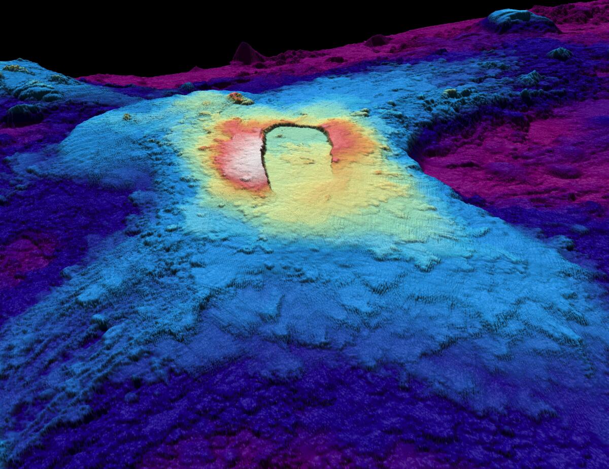
A three-dimensional topographic depiction showing the summit caldera of Axial Seamount, a highly active undersea volcano off the Pacific Coast. Warmer colors indicate shallower surfaces; cooler colors indicate deeper surfaces.
(Susan Merle / Oregon State University)
“For a lot of volcanoes around the world, they sit around and are dormant for long periods of time, and then suddenly they get active. But this one is pretty active all the time, at least in the time period we’ve been studying it,” Chadwick said. “If it’s not erupting, it’s getting ready for the next one.”
Scientists know this because they’ve spotted a pattern.
“Between eruptions, the volcano slowly inflates — which means the seafloor rises. … And then during an eruption, it will, when the magma comes out, the volcano deflates and the seafloor drops down,” Wilcock said.
Eruptions, Chadwick said, are “like letting some air out of the balloon. And what we’ve seen is that it has inflated to a similar level each time when an eruption is triggered,” he said.
Chadwick and fellow scientist Scott Nooner predicted the volcano’s 2015 eruption seven months before it happened after they realized the seafloor was inflating quite quickly and linearly. That “made it easier to extrapolate into the future to get up to this threshold that it had reached before” eruption, Chadwick said.
But making predictions since then has been more challenging. Chadwick started making forecast windows in 2019, but around that time, the rate of inflation started slowing down, and by the summer of 2023, “it had almost stopped. So then it was like, ‘Who knows when it’s going to erupt?’”

A deep-sea octopus explores the lava flows four months after the Axial Seamount volcano erupted in 2015.
(Bill Chadwick, Oregon State University / Woods Hole Oceanographic Institution / National Science Foundation)
But in late 2023, the seafloor slowly began inflating again. Since the start of 2024, “it’s been kind of cranking along at a pretty steady rate,” he said. He and Nooner, of the University of North Carolina at Wilmington, made the latest eruption prediction in July 2024 and posted it to their blog. Their forecast remains unchanged.
“At the rate of inflation it’s going, I expect it to erupt by the end of the year,” Chadwick said.
But based on seismic data, it’s not likely the volcano is about to erupt imminently. While scientists haven’t mastered predicting volcanic eruptions weeks or months ahead of time, they do a decent job of forecasting eruptions minutes to hours to days ahead of time, using clues like an increased frequency of earthquakes.
At this point, “we’re not at the high rate of seismicity that we saw before 2015,” Chadwick said. “It wouldn’t shock me if it erupted tomorrow, but I’m thinking that it’s not going to be anytime soon on the whole.”
He cautioned that his forecast still amounts to an experiment, albeit one that has become quite public. “I feel like it’s more honest that way, instead of doing it in retrospect,” Chadwick said in a presentation in November. The forecast started to garner attention after he gave a talk at the American Geophysical Union meeting in December.
On the bright side, he said, “there’s no problem of having a false alarm or being wrong,” because the predictions won’t affect people on land.
If the predictions are correct, “maybe there’s lessons that can be applied to other more hazardous volcanoes around the world,” Chadwick said. As it stands now, though, making forecasts for eruptions for many volcanoes on land “are just more complicated,” without having a “repeatable pattern like we’re seeing at this one offshore.”
Scientists elsewhere have looked at other ways to forecast undersea eruptions. Scientists began noticing a repeatable pattern in the rising temperature of hydrothermal vents at a volcano in the East Pacific and the timing of three eruptions in the same spot over the last three decades. “And it sort of worked,” Chadwick said.
Plenty of luck allowed scientists to photograph the eruption of the volcanic site known as “9 degrees 50 minutes North on the East Pacific Rise,” which was just the third time scientists had ever captured images of active undersea volcanism.
But Chadwick doubts researchers will be fortunate enough to videotape Axial Seamount’s eruption.
Although scientists will be alerted to it by the National Science Foundation-funded Ocean Observatories Initiative Regional Cabled Array — a sensor system operated by the University of Washington — getting there in time will be a challenge.
“You have to be in the right place at the right time to catch an eruption in action, because they don’t last very long. The ones at Axial probably last a week or a month,” Chadwick said.
And then there’s the difficulty of getting a ship and a remotely operated vehicle or submarine to capture the images. Such vessels are generally scheduled far in advance, perhaps a year or a year and a half out, and projects are tightly scheduled.
Chadwick last went to the volcano in 2024 and is expected to go out next in the summer of 2026. If his predictions are correct, Axial Seamount will have already erupted.

new video loaded: NASA Announces Artemis III Crew
transcript
transcript
NASA Announces Artemis III Crew
NASA announced the crew of Artemis III mission, which will fly to low-Earth orbit to test rendezvous and docking maneuvers with one or two lunar landers.
-
“I am excited to welcome you as the next crew in the Artemis journey to successfully return to the moon — this time to stay.” “I’m honored by the role that I’ve been given. I’m also very humbled by the task in front of us. But first and foremost, I’m grateful.” “So with that, the Artemis II crew, comrade, hands you the baton. You got the controls.” “As you know, we had a significant anomaly at our Launch Complex 36A on May 28. We’ve redoubled our efforts and are moving forward.”
By Alisa Shodiyev Kaff
June 9, 2026
Science
Santa Monica Mountains’ last steelhead trout survived the Palisades fire — and even had babies

Scientists feared the Santa Monica Mountains’ last remaining steelhead trout were dead, smothered by debris flows unleashed by the Palisades fire.
But the endangered fish surprised them: A team of biologists recently spotted 30 of the rare trout — and 21 babies — in Topanga Creek.
“There was a lot of happy dancing in the creek,” said Rosi Dagit, principal conservation biologist for the Resource Conservation District of the Santa Monica Mountains, which works with public and private landowners to conserve natural resources.
That’s because the steelhead here are endangered, at both the state and federal levels. Once, they swam in most streams of the Santa Monicas, but their numbers plummeted amid overfishing and coastal development. Increasingly frequent wildfire has further stressed their habitat. Topanga Creek, a biodiversity hot spot, is home to their last known population in the mountains that stretch from the Hollywood Hills to Point Mugu in Ventura County.
The trout that were spotted, including this one, are part of a distinct Southern California population that’s listed as endangered at the state and federal levels.
(RCDSMM Stream Team)
The California Department of Fish and Wildlife spearheaded a complex mission to rescue trout threatened by the Palisades fire that sparked in January 2025.
Time was of the essence. The fire hadn’t yet been fully contained. But rain was on the way, which would sweep massive amounts of sediment from the denuded hillsides into the water. Fish are often killed this way.
Crews stunned the fish with electricity, scooped them up in buckets, trucked them to a hatchery and ultimately moved them to Arroyo Hondo Creek in Santa Barbara County.
Within days, Topanga Creek was choked with mud. Some assumed the fish left behind were goners.
But in March, the conservation district’s team found four. The following month, when water conditions were clearer, they saw more.
“These fish continue to amaze me,” said Kyle Evans, environmental program manager for the state Department of Fish and Wildlife, who had seen the damage to the creek. “I had seen populations get wiped out in similar situations. So when I heard, I was thrilled.”
Evans surmises the fish that survived were in an area of the creek where less charred material and sediment were swept in.
“These fish likely hunkered down, were hiding under some rocks or places to try to get away from the main concentration of flow,” he said. “And luckily they weren’t buried.”
The ones that were spotted were fairly small, around 6 to 14 inches. Rainbow trout and steelhead trout are the same species, but with different lifestyles. If the fish remain in freshwater, they’ll be considered rainbows. However, they can migrate to the ocean and become steelhead, where they typically grow larger before returning to their natal waters to spawn.
Topanga Creek hasn’t fully recovered from the damage it sustained, but scientists say it’s looking better. Surveys last year were “so depressing,” Dagit said, with very few animals, and stretches that were essentially transformed into flat roads from all the sediment buildup. Some of the riparian canopy burned right down to the creek.
Then came 32 inches of rain over the last nine months, scouring out and moving sediment, creating deeper pools. Dagit said they recently found newt egg masses for the first time in years, as well as a few adult newts and many frogs. Plants that provide cover are starting to recover.
She provided photos comparing certain pools last year and this year, some dramatically transformed. In September 2025, the Shrine Pool could have been an overgrown hiking trail. This April, it was filled with shallow water.

The Shrine Pool in September 2025, left, and the same location in April 2026, right, with RCDSMM’s Isaac Yelchin donning a wetsuit.
(RCDSMM Stream Team)
Topanga Creek is home to another endangered fish, the small but hardy northern tidewater goby, often described as cute. Not long before the trout operation, Dagit led a rescue of hundreds of these fish too. Many were repatriated to the lagoon at the mouth of the creek in a moving ceremony last June.
There’s still the matter of what to do with the trout that were moved to Santa Barbara County last year. Evans would like to bring them home to the Santa Monicas at some point, but isn’t sure if it will happen. On one hand, they could bolster the small, genetically isolated surviving population. On the other, they might inadvertently bring in a disease or bacteria. There is some time to decide. Evans estimates the creek still needs to recover for two to three more years.
For now, the fish are functioning fine in their adopted creek. Experts worried the trauma wrought by the move would disrupt their spawning process, but they had babies that spring. This year, they spawned again.

The Pacifica Municipal Pier was shut down and taped off Thursday after city workers noticed cracks running through the landmark structure and concrete chunks falling into the ocean.
It’s just one of many coastal California structures that have recently crumbled under pressure from a rising and relentless ocean.
Officials from the small, beach city south of San Francisco said the pier was closed due to “cracking, separation, and displacement of the concrete walkway and structural elements.”
It will stay closed while structural engineers asses its safety.
Photos taken by city employees show a wide crack that runs from top to bottom and across the structure as well. Other photos show a large horizontal crack under the foundation of a small restaurant on the pier, the Chit Chat Cafe.
The cafe was also shut down.
This is not the first time the 53-year-old pier has shown signs of stress. In 2021, part of it was shut down after handrails along the edge collapsed. And in 2023, after a series of storms pummeled the Central California coast, damaging parts of the pier, the structure was partially closed for more than year.
Those same storms caused extensive damage in Aptos and Capitola, 70 miles south, where piers and waterfront infrastructure were swept away or damaged.
In 2024, a 150- to 180- foot section of the Santa Cruz wharf was ripped off by powerful waves.
At least 10 of the state’s dozens of coastal public piers were closed for part or all of 2024 due to structural damage sustained in winter storms since 2022. At least five others have longer-term upgrades planned to address structural issues.
“These things are costly to maintain,” said Zach Plopper, senior environmental director at Surfrider. “They are a part of our California coastal culture in many ways, but we’re going to need to reckon with, one, the state that they’re in, and two, the continuous and worsening threats they’re going to experience,”
He said most of the piers were constructed in the early 1900s, and they weren’t built to withstand decades of rough seas, storms and rising sea level.
“With this incoming El Niño, which is forecasted to be significant, and this marine heat wave we’re in the midst of, we’re kind of in uncharted waters as far as what this winter could bring in terms of storms and swells to the California coast, and we’re likely going to see a lot more damage,” he said. “Not just piers, but roads and other coastal infrastructure up and down the state.”
There was no storm in Pacifica earlier this week, so no single event could be blamed for the destruction.
However, a 2025 report from an outside engineering firm, GHD, found that several sections of the pier were in “poor” or “serious” condition, and they recommended closure before anticipated storms or events that could “subject the piles to high winds, swells and large waves.”
The firm found several areas of the pier where concrete was missing and rebar was exposed and corroding.
“The pier has continued to experience high winds and large waves in a harsh marine environment,” the engineers wrote in the report, noting that continuous exposure to seawater or marine spray was “detrimental” to the structure.
A 2023 city report estimated it would cost $19 million to repair.
That same year, a state law was enacted to require local governments along the California coast to plan for sea level rise in the coming decades.
Sea level has risen some 8 inches, on average, along the coast in the past 150 years, Plopper said, and researchers anticipate another foot in the next 25 years.
“We’re going to see profound shifts on our coastline, none that we have ever experienced before, and building static structures on the coast just doesn’t work all that well,” he said. “We’re going to have to make some really hard decisions.”
-

 Seattle, WA4 minutes ago
Survey: What’s the toughest game to start the Seahawks’ season?
-

 San Diego, CA11 minutes ago
Daily Business Report: June 10, 2026, San Diego Metro Magazine
-

 Milwaukee, WI14 minutes ago
50 electric school buses to transport MPS kids starting this fall
-

 Atlanta, GA19 minutes ago
Atlanta Dream hold off Chicago Sky 82-75, Rhyne Howard becomes youngest player to hit rare WNBA milestone
-

 Minneapolis, MN26 minutes ago
Operation Metro Surge cost Minneapolis $700 million, city leaders say
-
 Indianapolis, IN29 minutes ago
Person fatally shot on north side of Indianapolis
-

 Pittsburg, PA34 minutes ago
12+ things to do this weekend, from Pogopalooza and PizzaFest to the Beers of the Burgh Festival
-

 Augusta, GA41 minutes ago
World Cup: Where to find a crowd to catch all the action

