Massachusetts
Severe storms possible on summer-like Saturday

The weekend isn’t a washout, but we are dodging a few drops.
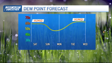
Today’s the warmest of the two, with summery highs in the low 80s – and a bit of humidity. There are exceptions to this warm warmth, however.

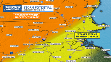
We are much cooler on the South Shore and Cape & Islands thanks to fog, low clouds, and a cool wind off the water. It’s here that the storm chance is minimal (or for the Cape/Islands, nil) in the afternoon.
Elsewhere, with sun, warmth, and humidity, we should see some storms fire up and get rolling any time after 2-4 p.m. and carry into the evening.
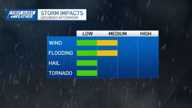
Our greatest chance of severe weather is across central/western Massachusetts and into southern New Hampshire.
Even so, many storms will be run-of-the-mill. For many, this will be considered a fine summer day with a few storms late day.


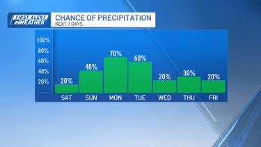
Sunday’s a different story. We’ll cool off with the onshore winds taking over. That will negate the storm threat and keep us mostly cloudy.
Here too, much of the day is dry as the showers will be few and far between. Highs could push 70, but we’ll drop to the 50s and low 60s in the afternoon with the wind switching to the east/northeast.

Showers will return for Monday along with chilly temps in the 50s. Tuesday’s washed out, and early Wednesday also looks wet. But what’s most intriguing is that the pattern is shifting next week. Right now, it appears we get all our wet weather out of the way early in the week, then enjoy a drying trend into NEXT weekend.
The timing couldn’t be more perfect as we head into May.
Have a great weekend and be safe!

Massachusetts
Two stabbed at Cedar’s Mediterranean Foods plant in Haverhill

Two people were seriously injured in a stabbing at the Cedar’s Mediterranean Foods manufacturing facility in Haverhill, Massachusetts, on Tuesday morning.
Haverhill police said they responded to the Cedar’s plan on Foundation Avenue around 10:30 a.m. for a report of a disturbance involving a weapon. When they arrived, they found two people suffering from apparent stab wounds.
Both people were provided with medical assistance on scene and taken to area hospitals with what police described as serious injuries. Their names have not been released, and no update on their conditions was immediately available.
Preliminary investigation determined that the two people knew each other, and police said there is no ongoing threat to the public. They said their investigation into the incident remains active.
Massachusetts
Injured Massachusetts teen thanks rescuers who

Two Plymouth, Massachusetts teens were saved from the summit of Mount Washington after a leg injury stranded them.
Khang Nguyen,17, said he and his friend, 18-year-old Vaughn Webb, thought they were well prepared for their hike on Saturday. They brought trekking poles, layers, microspikes for their boots and more.
But halfway up the trail, Nguyen feared the worst when his leg began to hurt.
“It was just incredibly painful to lift up my right leg,” he explained. “I told [Vaughn] to leave me behind so I could go on my own pace and for him to reach the summit to get help at first.”
The pair managed to reach the top of the mountain but had to seek shelter next to a building as wind gusts increased, and the air temperature reached 38 degrees. Nguyen said they also ran out of food and water. The New Hampshire Fish and Game Department received the 911 call around 7:30 p.m. and quickly alerted a State Park employee who began to search for the two teens.
“Conservation Officers then began responding in four-wheel-drive pickup trucks to try and get to the summit and back ahead of incoming snow,” the game department said in a statement.
After around 30 minutes of reaching both Webb and Nguyen were found. They were taken inside a building and Nguyen was being treated for his injury.
“The worker that was up there, [said] that they came in record time, and we appreciate their help a lot. It saved our lives potentially,” Nguyen explained.
The pair was successfully taken off the mountain by 10 p.m. The two teens are now safely back in Massachusetts and are incredibly grateful to their rescuers.
Massachusetts
Western Massachusetts libraries celebrating National Library Week – Athol Daily News

As libraries across western Massachusetts celebrate National Library Week from April 19 to April 25, they are honoring “the last real third space where everyone is welcome,” in the words of Greenfield Public Library Assistant Director Lisa Prolman.
According to the American Library Association, National Library Week is “an annual celebration highlighting the valuable role libraries and library professionals play in transforming lives and strengthening our communities.” This year, several libraries in the region will be hosting events to highlight the roles they play in their communities.
The Athol Public Library is among the venues engaging in National Library Week festivities, with a whole host of events starting on Tuesday, April 21, with Silly Goose Story Time at 10:30 a.m. The library will hold multiple events each day, including “Free Book Friday” on April 24, which Assistant Director Robin Shtulman said is “really fantastic.”
Shtulman said the week celebrates and emphasizes the “freedom to read, community outreach and celebrating the staff, without whom nothing would happen.”
The Athol Public Library said in an event announcement that “whatever brings you joy, the library has something for everyone,” and that aspect is being emphasized this National Library Week. To name a few of the events on tap, on Tuesday, April 21, from 3:30 to 5:30 p.m., there’s a volunteer opportunity where teens will make greeting cards for senior citizens; “A Minecraft Movie” will be shown at the same date and time; and on Thursday, April 23, the library will host Scavenger Hunt Bingo for all ages. For a full list of events at the Athol Public Library, visit atholpubliclibrary.com.
In Shelburne Falls, the Arms Library will feature a gallery from the Carlos Heiligmann Collection, a series of photos of public libraries across western Massachusetts. Also in collaboration with the Arms Library, Pothole Pictures and the Shelburne Falls Area Women’s Club will partner for a screening of “Free For All: The Public Library” on Saturday, April 25, at 2 p.m. at the Shelburne Falls Theater at Memorial Hall.
The documentary focuses on the evolution of the public library from its origins in the 19th century and the challenges it faces today, with modern-day issues such as book bans, funding cuts and debates over censorship.
It also explores the role that women’s clubs, like the one in Shelburne Falls, played in creating the modern library system. To serve their communities, women’s clubs took the lead in fundraising, collecting books and advocating for library legislation.
“Our women’s club in this town started with a group of 60 women who were gathering for lessons. … Because of the support of women in the U.S., we established over 80% of the public libraries [in the country],” said Christin Couture, program chair for the Shelburne Falls Area Women’s Club. “This film … I hear it’s so fascinating.”
Following the film’s screening, there will be a panel of local librarians who will engage in “lively conversation” about the history and future of public libraries. Tickets are $6, though school-age children will be admitted for free.
In Charlemont, Tyler Memorial Library will host an open house on Saturday, April 25, from noon to 2 p.m. featuring refreshments, a tour of the library and sun catcher crafting.
The Greenfield Public Library, meanwhile, is taking National Library Week in a bit of a different direction, as it is offering a book repair demonstration with Tom Hutcheson on Thursday, April 23, at 3:30 p.m. The day marks William Shakespeare’s birthday.
Although the book repair session required registration and is currently full, those who are interested may be placed on a waiting list at greenfieldpl.libcal.com/event/16460179.
Greenfield Public Library Director Anna Bognolo recognized the hard work that everyone has put into making the library a success, offering a “huge thank you” to the volunteers and staff who make its varied offerings possible.
“Stop by and support your library,” Bognolo said.
“Libraries, especially in this economy, are more important than ever,” Prolman said. Referencing the library’s role as a place where community members can go that is not work or home, she added, “They are the last real third space where everyone is welcome, and we don’t charge you for being here.”
-

 Culture4 minutes ago
Poetry Challenge Day 3: W.H. Auden, The Poet and His Technique
-

 Lifestyle10 minutes ago
Armani Goes Back to the Archive
-

 Education16 minutes ago
Video: Which Instant Coffee Is Best?
-

 Technology22 minutes ago
SpaceX cuts a deal to maybe buy Cursor for $60 billion
-

 World28 minutes ago
Pope Leo urges Africans to stay and ‘serve your country’ instead of migrating as displacement climbs
-

 Politics34 minutes ago
Democrats win Virginia redistricting fight, threatening Republican House majority
-

 Health40 minutes ago
Common eating habit may trigger premature immune system aging, study finds
-

 Sports46 minutes ago
Eli Manning fires back amid debate comparing ex-Giants star to Falcons great Matt Ryan


