


Miley Cyrus Claims Dad Billy Ray Once Smoked Pot on ‘Hannah Montana’ Set
Montana
Taylor Swift Performs ‘Hannah Montana’ Song ‘Crazier’ for 1st Time

Taylor Swift treated her audience in Edinburgh, Scotland to a treat when she chose to perform “Crazier” live for the first time ever. The song was released as part of the “Hannah Montana: The Movie” soundtrack 15 years ago.
In video shared on social media, Swift sang a mash-up of both “Crazier” and “All of the Girls.”
The then-teen country star Swift made a cameo in the 2009 film. “It’s so cool to become a part of the ‘Hannah Montana’ phenomenon,” she told reporters at the time. “It’s taking over the world right now. Honestly, it’s just so cool because ever since I figured out that I was going to be able to be in this movie, every time a little girl will come through one of my signing lines, or every single time I’ll see a little girl in one of my meet-and-greets and she’s got a ‘Hannah Montana’ shirt on, I want to be like, ‘Guess what — I get to be in that movie.”
You can watch Taylor’s “Hannah Montana: The Movie” cameo here:
The film’s production notes indicated that Swift became involved with the movie after she was approached by producers. The singer said she was asked to send in a song that “was perfect to fall in love to” and “Crazier” fit the bill.
Saturday’s show was Swift’s second of three concerts set for Edinburgh. She will round out her tour stops in the United Kingdom on June 30, then head to Amsterdam.
The first leg of Swift’s massive Eras Tour was the first set of concerts to gross over a billion dollars. Swift broke Elton John’s “Farewell Yellow Brick Road” gross record after 60 shows.
Watch the full music video for “Crazier,” featuring additional footage from “Hannah Montana: The Movie,” right here:

The Big Hole River, a blue-ribbon fishery that’s become a focal point in a years-long debate over nuisance algae growth, is poised to receive an impairment designation.
At an open-house meeting in Divide on Tuesday, the Montana Department of Environmental Quality announced that the Big Hole, a mellow freestone river critical to southwest Montana’s outdoor recreation and agriculture economies, is struggling as a result of ecologically detrimental nutrient loading.
The term DEQ is using in its discussion of the Big Hole is eutrophication, which describes the link between algae growth and excess nutrients such as nitrogen and phosphorus. When there’s too much algae in a river or lake, dissolved oxygen falls, imperiling fish and the aquatic life they feed on.
Algal growth is also unpopular with members of the recreating public because it can make wade-fishing a slipperier — and therefore more perilous — endeavor. And it drives down biodiversity in the macroinvertebrate population, which has repercussions for fish and other species higher up the aquatic food web. Andy Ulven, who leads DEQ’s water quality division, told Montana Free Press on Tuesday that a eutrophication listing would “formalize that there is an issue on the mainstem” of the Big Hole. He added that the agency proposal is still in draft stage and he doesn’t anticipate a final designation for the Big Hole until 2027 at the earliest.
The pending impairment designation is notable for a couple of reasons. In addition to establishing a new regulatory framework for the Big Hole, the designation creates a template that DEQ can use to determine if other medium-sized rivers popular with wading anglers are eligible for a eutrophication impairment.
DEQ’s Darrin Kron, who oversees the agency’s water-quality monitoring and assessment, explained that a eutrophication impairment designation would trigger regulations to reduce the inputs that contribute to poor water quality. Those standards are called Total Maximum Daily Loads, or TMDLs, and they’re often likened to a “pollution diet” for a compromised waterway.
In the case of the Big Hole, DEQ could develop TMDLs for nitrogen and phosphorus, as well as temperature-related standards to minimize new introductions of unnaturally warm water, which suppresses dissolved oxygen levels and contributes to algae growth.
Ulven anticipates that a eutrophication designation will increase the public funding that conservation groups like the Big Hole Watershed Committee and Trout Unlimited can apply for and put toward river-restoration initiatives. Projects those groups could work on — and are currently working on, if at a smaller scale — could include planting willows to add shade cover and reduce streambank erosion as well as intercepting nitrogen and phosphorus before they reach the river. Fertilizer runoff and livestock manure are common sources of nutrient pollution in agricultural valleys like the Big Hole.
The river’s algae issues have been well documented. Groups like Upper Missouri Waterkeeper, Save Wild Trout and the Big Hole River Foundation (which has since merged with Save Wild Trout) have been taking water-quality measurements and photographing summertime algae blooms on the river for six years to spur DEQ to rein in the nitrogen and phosphorus that are contributing to the algal blooms.
Guy Alsentzer with Upper Missouri Waterkeeper says the agency is playing “political hot potato” with impairment designations instead of acting with urgency to improve conditions on the Big Hole.
“It seems to be very disingenuous because it’s trying to avoid in any way, shape or form admitting that the key issue is that there are unhealthy and unnatural nutrient loading into the Big Hole River,” Alsentzer told Montana Free Press in a Wednesday morning interview. “A world-class, blue-ribbon stream for wild trout is on its knees. It has 40-year historic lows for trout recruitment.”
Alsentzer has long argued that the most proactive and scientifically sound way to reduce algal growth is to use numeric standards for nitrogen and phosphorus. But the Montana Legislature and DEQ disagree with him on this point, insisting that narrative, more subjective standards will suffice.
Last year, the Republican-controlled Legislature passed House Bill 664, which prohibits DEQ from using numeric nutrient standards. Proponents of HB 664 argued that it will result in more achievable and more affordable standards for the entities — water-treatment plants, mines and refineries, for example — that discharge nutrient-laden waters into Montana rivers.
HB 664 is the subject of an ongoing lawsuit Upper Missouri Waterkeeper filed in federal district court in January, maintaining that it doesn’t comply with the Clean Water Act, an environmental law Congress passed in 1972 to clean up polluted waterways. Alsentzer told MTFP that he anticipates the court will order a hearing on the matter at the tail end of this year and issue a ruling sometime in 2027.
Judge Brian Morris’ decision could determine whether DEQ can continue working with the eutrophication designation or whether it will be forced to return to numeric nutrient standards.
Water-quality concerns are likely to be exacerbated by the meager water supply currently in the Big Hole basin. The region received one of its worst snowpacks on record, and anxiety over a dismal summer forecast is a rare point of agreement among those who attended the Tuesday night open house.
Erik Kalsta, who ranches in the Big Hole Valley and is a longtime member of the Big Hole Watershed Committee, said he doesn’t anticipate the eutrophication-related impairment designation will drive significant changes to how he manages his land and water.
“I think the bigger worry for me is the messaging around this, especially on a bad drought year,” Kalsta told MTFP at the open house. He said he wouldn’t be surprised if the Big Hole goes dry in the next four or five weeks. That hasn’t happened since the late 1980s, and it spurred local irrigators to form the Big Hole Watershed Committee in search of cooperative water-management solutions.
“Our (irrigation) ditch right now is running about half of what it can carry,” Kalsta said. “That’s already forcing us to make choices about where we’re putting water, what kind of crops (we plant), what kind of summer we’re going to have.”
Brian Wheeler, executive director of Save Wild Trout, said the Big Hole is currently flowing at about one-quarter of its usual volume for this time of year. “It almost peaked in March, which is insane,” he added.
“If you can’t make more of it,” Wheeler said, “you can at least make sure what you have is clean.”
Montana
‘Hannah Montana’ Alum Mitchel Musso Reveals Why He Missed 20th Anniversary Special With Miley Cyrus

Hannah Montana star Mitchel Musso was noticeably absent from the show’s 20th anniversary special earlier this year — and now he’s revealing why.
“Of course they asked me [to be in it],” Musso, 34, revealed on the “Joe Vulpis Podcast” on Wednesday, June 24. “But, it wasn’t presented correctly [to me].”
Musso appeared in more than 70 episodes of the classic Disney Channel comedy series, playing Miley Stewart’s (Cyrus) best friend Oliver Oken alongside Emily Osment’s Lilly Truscott.
The star explained to host Joe Vulpis that he truly valued the opportunity to play Oliver again since he’d mostly been living outside the spotlight for the past decade. Instead, Disney opted for a retrospective look back at Hannah Montana.
Mitchel Musso, Emily Osment and Miley Cyrus on “Hannah Montana.” Joel Warren / Disney Channel / Courtesy Everett Collection
“I’ve been waiting ten years,” he stressed. “The people, they say, 20. My break’s been 10. It’s too long of a wait to do it in a way that isn’t even close to, in my opinion, correct.”
The Hannah Montana 20th Anniversary Special aired in March and featured Cyrus, 33, looking back on memorable moments from the show, alongside host Alex Cooper and celebrity guests such as Chappell Roan and Selena Gomez.
In his new interview, Musso said he would relish the chance of actually getting to play Oliver again in a proper Hannah Montana episode.
“I need a wig,” he joked. “I’d want the hair, which is fine. I’ve worn [wigs] plenty of times on Disney. I’ve worn plenty of wigs. … I’d want to feel the part again. I’d want to put on that little polo again, and wear the … plaid shorts with the goofy shoes.”
The actor went on, “I’d want to play the character, yeah. Once I saw myself doing it, I’d say, ‘Oh, there you are!’ Let’s get out there and let’s do it.”
Musso was not the only major Hannah Montana cast member missing from the anniversary special, as Osment, 34, could not appear due to her filming obligationa on CBS sitcom Georgie & Mandy’s First Marriage.
“We’re at Georgie & Mandy … and that’s why I was not able to be part of the 20-year reunion, because we are here shooting our show,” she said in a social media video at the time. “But I wanted to say hello and thank you to everybody that has stuck by us for all these years. I’m so grateful that you guys all still love the show. I’m so proud to be a part of it.”
Ahead of the Hannah Montana 20th Anniversary Special airing in March, Musso paid tribute to the show with his own Instagram post.


Miley Cyrus is still fielding questions about Hannah Montana more than a decade after its end — and she has some hilarious memories to share. During the Thursday, June 19, episode of her mom Tish Cyrus and sister Brandi Cyrus’ “Sorry We’re Cyrus” podcast, the Grammy winner, 32, opened up about a moment that never […]
“Hannah Montana wrapped around my heart and never really let go. We literally grew up with ya’ll — long days, crazy schedules, learning lines, cracking up between takes, and figuring out life while the cameras rolled,” he wrote. “It taught me so many wonderful values, but the most important ‘to me’ is that laughter can get you through the tough days. That confidence still sticks with me every single day.”
He also shouted out his costars, writing, “Miley, Emily, Jason [Earles], Billy Ray [Cyrus], Moises [Arias], and the whole crew at Disney — you became my family through all the real, messy, beautiful moments. Thank you for believing in a goofy kid from Texas who wore some questionable outfits with a haircut like that. To all of you, thank you for welcoming me into your homes and hearts 20 years ago and still allowing me to be here today. I’m honored we get to share all of this together.”
Hannah Montana originally aired for four seasons between 2006 and 2011. Classic episodes, as well as the Hannah Montana 20th Anniversary Special, can be streamed via Disney+.

ELK PARK — A father and his four sons reported missing near Elk Park were found safe after their vehicle became disabled, according to Butte-Silver Bow County Sheriff Ed Lester.
They were found walking along a roadway around 5 p.m. north of Maney Lake, according to Lester.
Rescuers from 15-90 Search and Rescue, the United States Marshals Service, the United States Forest Service, and the Bureau of Land Management (BLM) were able to reach the group and transport them to safety.
“We are very happy that everyone is safe. We appreciate the hard work of the rescuers and the coordination among Jefferson, Anaconda-Deer Lodge, Powell, and Silver Bow counties,” Lester said in a statement.
(original report) Law enforcement and search and rescue teams are searching for a missing father and his four sons near Elk Park, just off Interstate 15, after the group failed to return from a fishing trip north of Butte.
The group has been missing for nearly 24 hours. Three of the four boys are Type 1 diabetics in need of insulin.
WATCH: Law enforcement and search and rescue teams near Butte, Montana are searching for a missing father and four sons. Three of the boys are Type 1 diabetics in urgent need of insulin
Search expands for missing Butte family as friend reveals 3 of 4 boys are Type 1 diabetics
Courtney Mosier, a family friend who drove from Helena to assist in the search, said the urgency of the situation is critical.
“There (are) four little boys that range from ages 14 to 10. Three of the little boys are Type 1 diabetics. They need their insulin. They need their sugar. They need to be found immediately,” Mosier said.
Mosier has known the father, Paul Klimpel, her whole life and said his outdoor experience is a reassuring factor.
“Paul is an avid outdoorsman. Like I said, I’ve known him my whole life. If the truck broke down, Paul would be able to fix it. So, luckily they’re with a really, really, really good adult. We just need to find these children,” Mosier said.
Meagan Thompson
According to a press release from Butte Sheriff Ed Lester, police are searching for the group in the Brown’s Gulch, American Gulch, Flume Gulch, and Bernice area north of Butte. Officials are also searching the Homestake and Delome Lake areas.
The last known location of the group came from a cell phone ping near Maney Lake.
“The last ping from one of the little boys’ cell phone was up near Maney Lake so that’s where the family is at currently right now,” Mosier said.
Butte-Silver Bow County Sheriff’s Office Butte-Silver Bow Sheriff’s Office

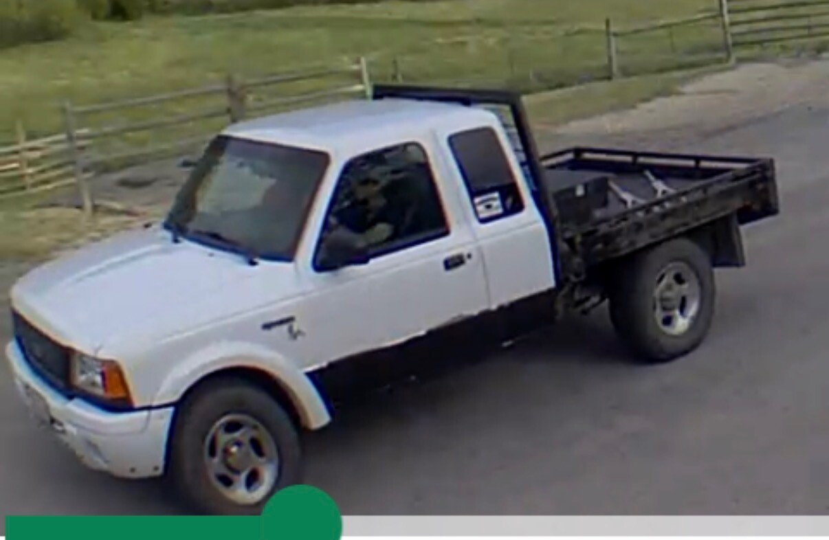
Anyone who spots a white Ford Ranger flatbed pickup is encouraged to call law enforcement at 406-497-1120.
This story was reported on-air by a journalist and has been converted to this platform with the assistance of AI. Our editorial team verifies all reporting on all platforms for fairness and accuracy.
-
 Entertainment2 minutes ago
La Cruz offers a musical memorial to Pulse shooting victims on Pride Month
-
 Politics14 minutes ago
Controversial billionaire tax proposal will appear on November ballot
-
 Sports22 minutes ago
Shohei Ohtani is the first Dodger to be named 2026 All-Star
-

 World32 minutes ago
Who will control Africa’s AI infrastructure and at what cost
-
 News59 minutes ago
The Supreme Court says the U.S. can turn away asylum seekers at the border
-

 Los Angeles, Ca2 hours ago
Jury says it is deadlocked in trial of man accused in Palisades Fire
-

 Detroit, MI3 hours ago
Scene active as police shoot, kill man on Detroit’s west side
-

 San Francisco, CA3 hours ago
Civil grand jury report warns of wildfire risk at SF’s Glen Canyon Park

