Denver, CO
Denver area faces hazardous Wednesday morning commute as heavy, wet snow begins to fall
DENVER — A strong, late-season snowstorm has moved into northern Colorado and the Front Range Tuesday evening and will continue into Wednesday, making for a hazardous morning commute.
MORE | Denver7 weather blog
The National Weather Service has issued a winter storm warning from midnight Tuesday through 3 p.m. Wednesday.
How much are we getting?
The NWS forecasts 5-8 inches of snow for the Interstate 25 corridor, while areas closer to the foothills could receive up to 9 inches.
For the Eastern Plains, forecasters expect 2-6 inches of snow, a lower total than in the Front Range.
The Northern Mountains and foothills could receive as much as 2 feet of snow, with Estes Park and surrounding areas seeing early accumulation Tuesday afternoon.
Meanwhile, the Southern Mountains are forecasted to get 6-14 inches.
NWS
When will it get here?
In Denver, rain began to transition to snow around 5 p.m. And snow accumulation is expected to continue into Wednesday afternoon, according to the NWS.
Forecasters expect that from Tuesday at midnight to 9 a.m. Wednesday will see the brunt of this storm in the Denver metro area.
NWS


What are the biggest concerns?
That midnight-to-9 a.m. stretch of snowfall should have the biggest impact, according to the NWS.
Wet, heavy snowfall poses the greatest risk for broken branches and tree damage, especially in areas with the largest accumulations, which can cause scattered power outages.
Hazardous conditions, especially for the morning commute in the Denver metro area, are expected due to heavy snowfall. The Colorado Department of Transportation is prepared for these impacts.
CDOT said there will be about 100 plows throughout the storm, focusing on clearing interstates and major roadways first before secondary roads.
Tuesday evening forecast
When will it skidaddle out of here?
Snow accumulation should end north to south by midday Wednesday, with drier weather moving in Wednesday night into Thursday.
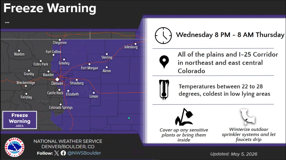
Denver will see a high of 39 degrees with a low dropping below freezing on Wednesday. A freeze warning is likely on Wednesday night.
Thursday, we may see a shower or two, but mild springlike conditions will return.
NWS

Weather Links
MORE: Hourly forecast | Latest forecast | Radars | Traffic | Weather Page | 24/7 Weather Stream
Stream live, current temperatures plus radars across Colorado anytime for free on the free Denver7+ app on your TV or watch from your computer or mobile phone anytime.