Maryland
Weekend washout: Chilly temps and rainy forecast may dampen Maryland’s Homecoming game

BETHESDA, Md. (FOX 5 DC) – After a warm start to October that featured almost a week of 80° temperatures, it has been feeling much more like fall as the middle of the month approaches.
Overnight lows hit the middle 40s this past Monday. It was one of our coldest mornings since late April – all while we continue to lose about two-and-a-half minutes of daylight each and every day.
Thankfully, despite the chilly starts, much of this week has featured sunshine and comfortable afternoons. Unfortunately, this is something that is likely to change by the time we hit the weekend.
While the end of the workweek here will feature sunshine, a surface low will be developing and strengthening out in the Northern Plains through Thursday and Friday, before pushing eastward and deepening along with an upper-level area of low pressure into the weekend. At the same time, an additional, weaker storm system will develop in the eastern Gulf of Mexico. This storm system will get pulled northward and absorbed into the stronger storm to the north but will add additional moisture for the storm to tap into.
This is all a recipe for what is expected to be a cool, cloudy, and wet weekend.


Temperatures are likely to be stagnated for much of Saturday as the system comes across. We’ll have a chilly start to the weekend across the D.C. region, but a lucky few will see some middle 60s, while most areas will see temperatures in the lower 60s.
While we are still narrowing down the exact timing on the steadiest rains, as things stand at the moment, the morning hours are likely to see the showers moving in from west to east, with steadier rains expected for the afternoon and evening hours. Periods of heavier rains will be possible. Sunday all depends on the forward speed of the system. While many models show clouds, light showers or drizzle during the morning hours, a few do show the potential for some clearing later in the day. Unfortunately, it is likely to be a rather chilly and breezy day, with most of the region staying in the 50s all day Sunday.
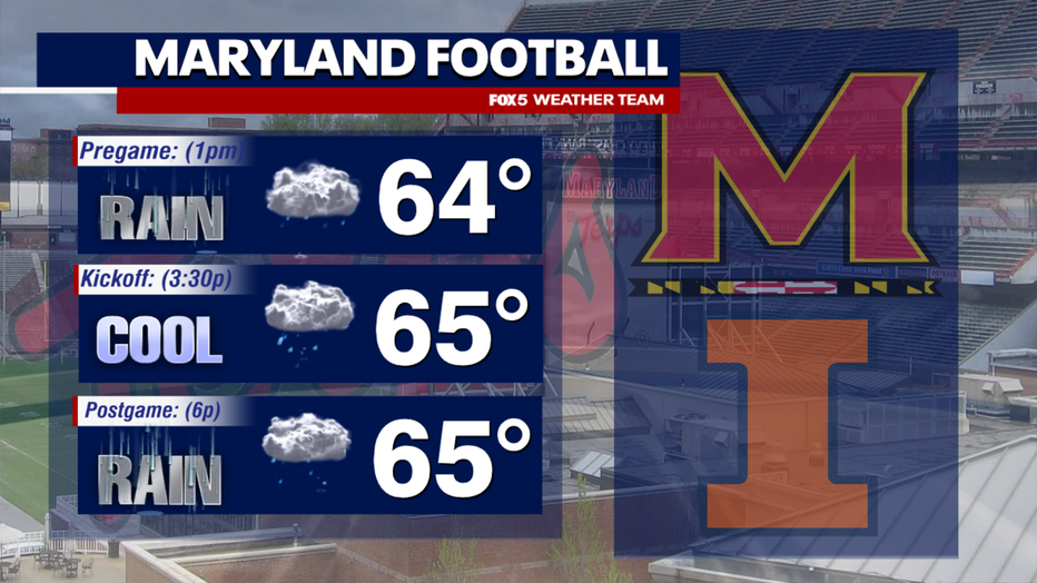
If you do have outdoor plans this weekend, at the moment I will not lie to you and say that it is looking like the best weekend out there. It is the season of fall festivals, haunted forests, and outdoor football and soccer games, and some of those could get the washout treatment on Saturday afternoon and evening. This includes the University of Maryland’s homecoming football game on Saturday against the University of Illinois. Kickoff is set for the middle of the afternoon at 3:30 p.m. and most model guidance suggest that it will be a pretty wet game. Come prepared with ponchos and an umbrella to root on the Terps!

Even though it is never much fun when the rain ruins weekend plans, much of our region does continue to need the rain.
Parts of our region, mostly to the west near the I-81 corridor, remain under a severe drought and are in desperate needs of some beneficial rains. At this time, most guidance suggests between 0.5-1.5″ of rain for the region through the course of the weekend. While it would not be enough to eliminate the drought, it would certainly improve the situation in the areas that need it most.

Behind the storm system, another round of cooler air will swing down from Canada, keeping much of next week cooler than average for the middle of October.
Most of the week will be spent with highs stuck in the lower to middle 60s. We mentioned at the start of the month that the 80s the first week of October could be the last of the year, and so far everything in the pattern is suggesting that this will indeed be the case.

The cooler weather comes just as more fall colors are expected to show up across our region. According to leaf forecast from ExploreFall, our western zones should start seeing more color coming out by the middle of next week.
For the immediate D.C. metro area, all signs are still pointing towards the end of the final week of the month for peak color.