Science
Fast, wet and furious: How the North American monsoon floods the California desert

In the middle of summer, most Southern Californians would be surprised to see more than a handful of clouds in the sky (unless you count clouds of wildfire smoke). But on July 14 in Twentynine Palms, a rapidly developed thunderstorm dropped about 1.88 inches of rain in a couple hours — an overwhelming amount by historical standards for a town that typically gets less than 4 inches in an entire year.
The water rushed along streets and highways, picking up cars and driving debris to damage homes and businesses. Then, while residents were still taking stock of the destruction, nine days later the area was under a flash flood warning again as another thunderstorm moved through.
So why does the Mojave Desert — obviously an extremely arid place — receive all this summer rain while Los Angeles, less than 150 miles away, gets none?
Aggressive and impactful reporting on climate change, the environment, health and science.
Late summer is the driest time of year for much of California; on average, Los Angeles International Airport receives no rain at all during the month of August. But if you go east over the mountains into San Bernardino County, the pattern suddenly switches — in Twentynine Palms, August is the wettest month. Keep going into Arizona and New Mexico and the late summer precipitation gets even more intense: In Santa Fe, almost half of the year’s rain falls between July and September.
This changeover is the result of a phenomenon called the North American monsoon, which was responsible for the deluge in Twentynine Palms. While it is less well-known than its South Asian counterpart, the North American monsoon plays an important role in the climate of the Four Corners states, bringing crucial moisture to areas that would otherwise be bone dry, but also at times leading to damaging flooding.
All monsoons are driven by the same source: a difference in temperature between land and ocean. During the hot months of late summer, the sun can deliver as much as 1,000 watts per square meter in the subtropics — in terms of power, that’s similar to running a space heater every four feet. Some of this power is reflected into space, but on average more than two-thirds of it is absorbed, either by the land surface or by the ocean.
The essential difference between the two is that the ocean is constantly mixing, which distributes the heat throughout approximately the top 60 feet of ocean water — something that is impossible on land. As a result, the top few inches of soil or rock heat up rapidly over the course of a day, and in turn warm the overlying air.
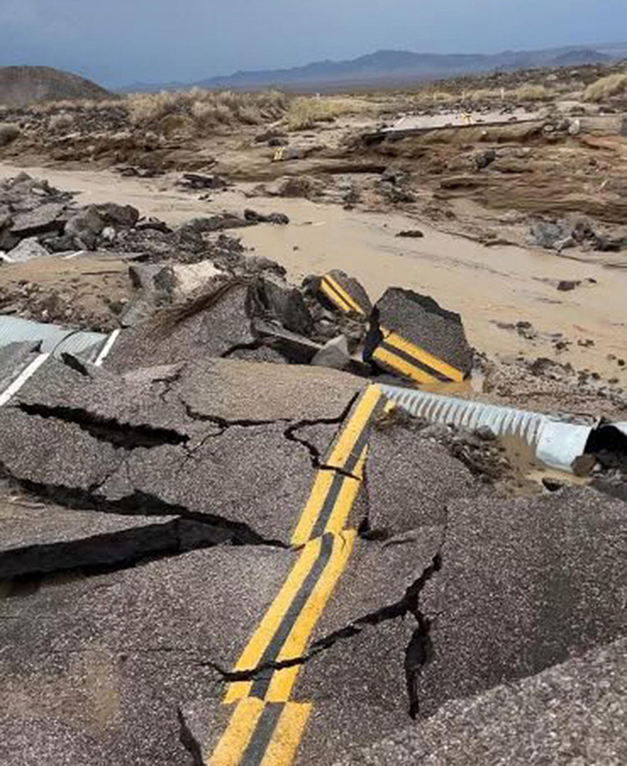
Monsoon flood waters buckled and damaged the roadway at Kelbaker Road and Mojave Road inside the Mojave National Preserve in August 2022.
(NPS)
Since hot air is less dense than cold air, the air over the land tends to rise, typically in the late afternoon after a full day of baking in the sun. As the air rises from the land, it pulls in moist air from the water — for the North American monsoon, this is the Gulf of California — to replace it. When this moist air reaches mountainous terrain like that of northern Mexico and the American Southwest, it is pushed up and drops its moisture, often in sudden, intense thunderstorms.
There are many places near the coast that don’t have monsoons — Los Angeles, for instance. One important factor is topography: Research suggests that a major reason why the South Asian monsoon is so powerful and consistent is the presence of the Himalayas, which act as a wall that prevents air from the dry Tibetan plateau from making it to the Indian subcontinent.
Another major consideration is something called the “subtropical ridge,” which is a series of persistent high-pressure systems that all occur around 30 degrees north (and south) of the equator.
The reason that the North American monsoon does not reach coastal California is the presence of the North Pacific High, which is a part of the subtropical ridge that typically sits northeast of Hawaii. The North Pacific High strengthens and expands during the summer, creating the hot, dry conditions that are typical for Los Angeles and crowding out the monsoon. In winter, however, the North Pacific High tends to weaken and shift south, allowing atmospheric rivers to reach the state.
For the Southwest, the North American monsoon can be both a blessing and a curse.
It brings much-needed rain to the region, but that precipitation typically falls in torrential downpours that the dry, hard-packed soil is unable to absorb. This leads to dangerous flash floods that can destroy roads and buildings and potentially claim the lives of those caught in their path. The rain and cool conditions delivered by the monsoon can be useful in extinguishing wildfires, but the lightning from the storms is also a major trigger for wildfires in the region.
As with many weather phenomena, climate change is expected to have some effect on monsoon rainfall, but the magnitude and direction of that effect depends on specific local factors.
For some parts of the globe, like South and East Asia, monsoons are predicted to become more intense because of climate change. It is thought that changes in aerosol pollution as China and India (hopefully) shift away from coal power will play a very important role.
In the southern hemisphere, models suggest a possible small increase in summer monsoon rainfall. Of the major monsoon systems, only the North American monsoon is expected to have substantial decreases in total precipitation, with the most likely outcome being a 1%-6% reduction in summer rainfall. The reasons for this predicted decrease are not entirely understood but warming sea surface temperatures off the coast of Baja California have been suggested as a possible explanation.
If the North American monsoon does weaken over the coming decades, it will put further stress on the dwindling Colorado River, which has a watershed that includes almost all of Arizona and large swathes of Colorado and Utah. Perhaps more significantly, it will represent a serious threat to ecosystems that are already fragile because of rising temperatures and outbreaks of the mountain pine beetle.
The future of monsoon systems across the globe is not certain or easily predictable but given the potential perils in either direction — more intense flooding or deepening drought — it is important that we prepare for both scenarios and act quickly to limit these changes including by rapidly cutting emissions.
Ned Kleiner is a scientist and catastrophe modeler at Verisk. He has a doctorate in atmospheric science from Harvard.
Science
July Fourth fireworks may bring ‘hazardous’ air quality to Southern California. What you need to know

L.A.’s love of fireworks makes for a colorful Fourth of July, with dozens of official celebrations and countless illicit explosions expected for the holiday.
But as each sparkler, Roman candle, palm and peony dissipates, it leaves behind a cloud of noxious gases, soot and finely ground toxic metals — some of which ends up in the lungs of revelers and passersby below.
Hazardous levels of air pollution are expected across central and southern Los Angeles County, northern Orange County, and Riverside and San Bernardino counties from 5 p.m. Saturday evening through 3 p.m. Sunday, according to the South Coast Air Quality Management District. Unhealthy air quality is also expected in northern Los Angeles County and southern Orange County.
Pollution levels are expected to build from dusk onward Saturday, as light winds and increased firework activity lead to an increase in smoke, a South Coast AQMD advisory said. Soot and particulates will likely linger through Sunday afternoon before being dispersed by the wind.
Firework-related pollution can trigger coughs, breathing problems, asthma flares and heart attacks, according to Los Angeles County Public Health, and anyone experiencing severe or worsening cardiovascular symptoms like chest pain or difficulty breathing should seek medical attention immediately.
Pyrotechnics set off at home are even more likely to trigger cardiovascular problems, the American Lung Assn. says, as the burst of pollutants takes place closer to the ground.
July 4 and 5 are traditionally two of the worst days of the year for the region’s air quality, according to South Coast AQMD. This year’s celebration comes on the heels of a late June warehouse fire in Boyle Heights that released extraordinary amounts of soot and smoke across the county, on par with pollution generated by the previous year’s wildfires.
To limit negative health effects, the L.A. County public health department recommends avoiding strenuous physical activity and keeping doors and windows closed. As whole house fans and swamp coolers can suck additional pollutants inside, the department recommends using air purifiers or air conditioners as alternatives when possible.

Few substances are as deeply woven into everyday life as alcohol. It is a fixture at holiday celebrations, work-related social gatherings, sporting events, airports, and brunch or dinner tables. All demonstrate how deeply alcohol has become embedded in social customs and cultural traditions.
Yet alcohol contributes to millions of deaths globally each year and is linked to cancer, liver disease, unintentional accidents, violence and, importantly, dependence and addiction. Despite this, the disconnect between alcohol’s cultural role and its serious health burden is striking. An estimated 2.3 billion people worldwide consume alcohol.
As a physician working in addiction medicine, I regularly care for patients whose alcohol use affects nearly every organ system. It is often not until these patients end up admitted to the hospital that they learn the effects of alcohol on various parts of their body besides their liver.
Newer evidence challenges assumptions about what was long considered “safe drinking.” Even moderate drinking carries risk and is not as harmless as people, including experts, once thought.
Many people associate alcohol risk primarily with addiction or dangerous behaviors such as driving while intoxicated. However, its effects extend far beyond this, into nearly every aspect of a person’s well-being.
While alcohol may transiently improve mood and ease social anxiety, long-term alcohol use can lead to a worsening of mood, cognition and sleep, which can further compound use.
A 2021 literature review found that consuming approximately two standard drinks roughly doubles the odds of sustaining injuries — with or without a vehicle involved. The review also found that heavy episodic (binge) drinking can increase the risk of injury by 50-fold, depending on the amount of alcohol consumed and the type of injury. While alcohol’s effects on the liver are well known, it can also lead to gastrointestinal complications and heart disease
The World Health Organization estimates that 2.6 million deaths each year are attributable to alcohol, accounting for nearly 1 in every 20 deaths worldwide.
While many people recognize the risks of alcohol addiction, people are generally much less aware of the links between alcohol use and cancer risk.
The World Health Organization classifies alcohol as a Group 1 carcinogen — the same category as tobacco and asbestos. In 2025, the U.S. surgeon general emphasized that alcohol increases the risk of at least seven cancers, including cancers of the breast, colorectal, liver, oral, esophagus and larynx. An advisory called for updated warning labels.
Yet fewer than half of Americans recognize alcohol as a risk factor for cancer, particularly for cancers such as breast cancer that are not commonly associated with alcohol use.
Throughout the 1990s and early 2000s, observational studies suggested that moderate alcohol consumption might offer cardiovascular benefits. Over the past decade, however, higher-quality studies have challenged these findings, suggesting that much of the apparent benefit may have reflected differences in the health and lifestyles of moderate drinkers rather than a protective effect of alcohol itself.
Current evidence increasingly suggests that even low levels of alcohol may increase cancer risk.
Federal guidelines acknowledge that adults should “consume less alcohol for better overall health.” However, the most recent version of the “Dietary Guidelines for Americans,” updated in January, removed the previous recommendation to limit intake to no more than one drink per day for women and two for men. It also omitted explicit discussion of alcohol’s links to cancer.
These changes have drawn criticism from public health experts, who argue that the revised language plays down the growing evidence of alcohol-related harms and provides less specific guidance to consumers. The current administrator of the Centers for Medicare & Medicaid Services characterized alcohol as a “social lubricant” that brings people together, rather than emphasizing its well-established health risks.
This may be true physiologically, at least temporarily, but obscures the fact that relying on it as a social lubricant can lead to chemical and psychological dependency. In my view, statements to that effect are shortsighted, prioritizing short-term social effects over more insidious and long-term issues, including addiction.
While many dangerous mind-altering substances are hidden from public perception, alcohol is often placed at the center of it – a trend that shows no sign of changing imminently.
Further, large companies often profit from ads that appeal to young people.
Looking back at the history of tobacco smoking provides some helpful insights. In 1965, 42.4% of the U.S. population smoked. By 2022, that figure had dropped to 11.6%.
This steep decline did not happen because of a single intervention, but through decades of accumulating scientific evidence, public education campaigns, warning labels, restrictions on advertising, smoke-free policies, higher tobacco taxes and shifts in social norms. Together, these efforts transformed smoking from a widely accepted social behavior into one broadly recognized as a major health risk and correspondingly, less socially accepted.
Although alcohol consumption has modestly declined in recent years, it remains deeply embedded in social life in ways cigarette smoking no longer is.
People often assume that if a substance is legal, common and widely socially accepted — even encouraged — it must also be safe. But public health history suggests those assumptions can and should change.
Emma Fenske is an addiction medicine fellow and internal medicine physician at Oregon Health & Science University. This article was produced in partnership with the Conversation.

The air near the Lineage refrigerated warehouse fire in Boyle Heights carried astronomically high levels of smoke and soot, surpassing some of the worst air pollution during the Los Angeles County fires in January 2025, according to preliminary data from air officials.
The fire spewed thick black smoke for days. From downtown Los Angeles to the San Gabriel Valley, tens of thousands were enveloped in unhealthful levels of smoke, even as some local officials told residents that the air posed no danger.
As the days wore on, worst off were communities nearest the blaze. On June 19, three days after the facility ignited, a temporary air quality monitoring station at Eastman Elementary in unincorporated East Los Angeles measured an extremely hazardous 755 micrograms per cubic meter of fine particles for more than an hour, according to the South Coast Air Quality Management District.
For comparison, a Caltech air monitor in Pasadena recorded about 650 micrograms per cubic meter during the Eaton fire.
These high levels of fine particles, known as PM 2.5, probably resulted in the surge of residents into local emergency rooms during the fire, according to local health officials. But even now with the smoke gone, people still have not been told what chemicals they were breathing in during the weeklong ordeal.
Michael Jerrett, an environmental health professor at the UCLA Fielding School of Public Health, said his concern is the composition of materials emitted when the building burned.
“These contain many particularly toxic components,” Jerrett said, “and we know little about how these mixtures affect health.”
There is no completely safe level of fine particulate pollution, he noted, meaning higher concentrations are always worse.
During the 2025 L.A. County fires, local air officials announced that several monitors downwind had detected elevated levels of brain-damaging lead and cancer-causing arsenic from toxic paint and construction materials used in older homes.
The Lineage warehouse, built in 2018, is likely to contain different materials of concern. Thick insulation foam required for a massive refrigeration operation, solar panels and refrigerants were burned, leaving many residents on edge.
Even though three public agencies conducted air monitoring, the picture is still murky.
“[Public officials] are speaking with a lot of confidence but not a lot of information,” said mark! Lopez, a community organizer with East Yard Communities for Environmental Justice. “We’ve gotten in the room with folks to discuss where the gaps lie and where assumptions are being made. And I think they are realizing these agencies supposed to protect our air and our health aren’t as reliable as they thought they were.”
In response to the Boyle Heights fire, the South Coast air district deployed a mobile monitoring vehicle to screen for toxic substances in the community near the fire, according to Nahal Mogharabi, a spokesperson for the air district. It found increased levels of bromine, a chemical commonly found in fire retardant, and chlorine, often released from burning plastic. Both were below short-term health-based exposure thresholds.
Toxic metals, including lead and arsenic, were not elevated, according to air district data.
“That was the reassuring piece, that they were not picking up any of the metals,” said Dr. Nichole Quick, chief medical advisor for the Los Angeles County Department of Public Health. “But … that smoke is unhealthy. “You don’t want to be breathing it, regardless.”
The U.S. Environmental Protection Agency set up air monitors around the perimeter of the facility to test for toxic air contaminants, has the results and has not made them public. Julia Giarmoleo, an EPA spokesperson, said the monitors did not detect elevated metals, but would not provide a copy of the data without a federal records request.
The Los Angeles Fire Department’s hazardous material team also tested for ammonia, which is used in refrigeration, and hydrogen fluoride, a toxic chemical that could be released by burning lithium-ion batteries and solar panels.
Fire officials previously said they measured low levels of hydrogen fluoride on the second day of the fire. But the department would not answer questions about its air monitoring. It also told a reporter to submit a public records request.
It remains unclear whether any agency has tested for hydrogen cyanide or isocyanates, highly toxic gases that could be released from burning chemical-laden insulating foam inside the building.
“The real issue is what monitoring has not been done to protect the fence-line community from the air toxics,” said Jane Williams, executive director of California Communities Against Toxics.
Without the EPA or LAFD data, what is known of the smoke’s toxicity rests on the air district’s mobile monitoring.
Jerrett, the UCLA researcher, said that is not ideal for understanding the kind of plume released by the Boyle Heights fire, which rapidly changed direction with the wind.
“This can in some instances lead to levels that look low, but they are resulting from a mismatch between the location of the vehicle and the plume,” he said.
The Boyle Heights blaze, similar to the Eaton and Palisades fires, has revealed the region’s air monitoring can’t always tell people what they’ve been exposed to in a disaster.
“We do need a better monitoring system in place,” he said.
Local officials are now shifting their focus to the rancid odors from millions of pounds of rotting food in the ruined wing of the warehouse. Decomposing food can release hydrogen sulfide, a toxic gas synonymous with landfills and garbage. Lineage hired contractors who are measuring this noxious gas and other pollution. Their data indicate they have not detected hydrogen sulfide.
As Lineage workers haul the rotting food to local landfills, they are using deodorizing mist and have discussed using shrink wrapping to suppress the stench and minimize issues for nearby homes.
At this point, the odors are believed to be an inconvenience rather than a public health threat, according to Quick, the county medical advisor. She said running air purifiers may help to reduce odors indoors.
“It’s very important for folks to understand that the odors themselves do not indicate any dangerous levels of toxins, mold, bacteria, and so forth,” Quick said. “But the odors are a public nuisance.”
The air district is still encouraging residents to report odors to its online complaint system or by calling (800) 288-7664.
-
 Washington, D.C1 minute ago
Masked men carrying Confederate flags seen chanting, marching, in Washington DC
-

 Cleveland, OH8 minutes ago
Chicago White Sox vs. Cleveland Guardians prediction, pick for Friday 7/3/26
-
")
") Austin, TX11 minutes ago
Austin, TX11 minutes agoSouth Texas Health System (@stxhealthsystem)
-
 Alabama16 minutes ago
5-Star OL commits to Texas over Alabama and others
-

 Alaska23 minutes ago
Semi overturns on highway north of Seward, spilling salmon
-

 Arizona26 minutes ago
Arizona gets commitment from 3-star Texas OL Mason Joshua
-

 Arkansas31 minutes ago
Why Unheralded CJ Brown Could Be Arkansas’ Answer at WR1
-

 Colorado41 minutes ago
Most Expensive Colorado Buffaloes Road Tickets This Fall

