


The remainder of the bracket is going to be tough for the Michigan Wolverines, including Sunday’s tilt against the Tennessee Volunteers, but of the two options for the Elite Eight, this was the preferrable opponent. Analytics believe this squad is underseeded (No. 11 overall per Kenpom), but compared to the swarming defense of Iowa State, the Wolverines have to feel great about their chances of advancing to the Final Four.
Michigan
Michigan weather: ‘Just wait. It will get worse’ – City Pulse

By TYLER SCHNEIDER
On the morning of June 17, Richie Waters and his partner, Miles Abdal, left their apartment at The Quarters in East Lansing to find the latter’s car mostly covered in water in the parking lot.
Abdal was planning on driving Waters to work that morning, but the damage totaled his car. Abdal was fortunate enough to have an insurance policy that covered the loss, but the pair decided to take additional precautions.
Weeks later, when they heard about another heavy rainstorm expected to arrive early July 9, the pair parked the car farther away, where it would be safe from flood damage.
They were thankful for that foresight. Spurred by Hurricane Beryl, last week’s storm brought as much as 5 inches of rain to East Lansing in two hours and approached 7 inches by day’s end. At its peak, Waters estimated that the deluge filled roughly 60% of The Quarters’ parking lot. At least one car was a few inches short of submerged.
While last week’s flooding didn’t come close to matching the intensity of a historic 1975 flood that led to some of the highest water levels on record for the Grand and Red Cedar rivers, local experts say that climate change could result to an increased probability and frequency of major flooding.
Wonmin Sohn, an assistant professor in Michigan State University’s landscape architecture program, said that while Greater Lansing isn’t generally seen as a high-risk flood area, “climate change has made accurate precipitation prediction more challenging, increasing the possibility of unprecedented flooding even in cities previously considered safe from such events.”
Hurricane Beryl, which began June 29 and peaked July 2, is a historic outlier supporting this theory. The National Oceanic and Atmospheric Administration cited it as “the earliest Category 5 hurricane observed in the Atlantic on record,” in part due to warmer-than-average oceanic temperatures.
The fallout of this unusually early hurricane could be traced from Houston up through southeastern Michigan, where notable local damages included a collapsed roof at Kositchek’s Menswear in downtown Lansing and $15,000 in losses at Forster Woods Adult Day Center in East Lansing.
Sohn said there’s good reason to believe that these high-intensity, short-duration storms may become more common as temperatures continue to rise through global warming. So far in 2024, with February being the lone exception, she said Michigan has “consistently shown early signs of above-average precipitation and an abnormally warm winter and summer.”
“The transition from El Niño to La Niña, beginning in early 2024 and continuing through the summer, has contributed to unusually high rainfall and localized intense precipitation events across the Great Lakes region. This shift has increased the complexity and unpredictability of precipitation,” Sohn said.
The trend goes far beyond the United States, with Sohn noting that the Intergovernmental Panel on Climate Change “predicts more intense and heavier storm events, leading to increased severe flooding.”
“For the Great Lakes region, projections indicate that flooding will intensify and be coupled with extended dry periods,” Sohn said. “By the end of the century, spring and fall are forecasted to bring substantially more severe and recurrent storms, amplifying the strain on healthcare services and public infrastructure.”
As this process plays out, Sohn said Michigan’s humid continental climate — which typically yields warm summers and fairly cold winter months — is projected to shift toward even warmer-than-average year-round temperatures.
“Summer warming is expected to lead to higher evaporation rates, more intense heat waves and longer periods of drought. Conversely, winters, while still cold, are projected to become milder with less snowfall and more rain,” she said.
“These changes will significantly impact flooding patterns in Michigan. Warmer summers with intense rain events will lead to increased runoff, overwhelming stormwater systems and causing urban flooding. Milder winters with more rain instead of snow will contribute to more frequent winter and spring floods as snowmelt decreases but rainfall increases,” Sohn added.
Nicole McPherson, a Lansing city engineer who joined the city last year after seven years with the city of East Lansing, agreed, noting that major rainfall events are “getting more unpredictable and intense.”
Most municipal stormwater management systems are typically designed to withstand a 10-year storm, or one that McPherson said has a 10% probability of happening in any given year. According to the City of East Lansing’s website, the storm that totaled Abdal’s car in June featured rainfall that “occurred predominantly over a period of one to two hours, qualifying it as a 200-to-1,000-year storm event under current classification systems.”
McPherson said it was fair to describe a 100-year storm, which has a 1% chance of occurring each year, as a “major” event.
“I’m going to put a big ‘but’ on this, though, because we’re seeing more and more of these 100-year storm events,” she added.
Cliff Walls, East Lansing’s environmental sustainability and resiliency manager, the city is working on new standards for predicting the likelihood of floods.
Walls cited data showing a 75% increase in short-duration storm events — or heavy showers that can range from a few hours up to a full day — for the area between 1949 and 2023.
“There’s a finite amount of hydraulic capacity in the drainage infrastructure. So, when it comes down fast, like in this one- or two-hour storm we saw last Tuesday, that’s more problematic for drainage infrastructure, because it’s not something that systems have historically been built for,” Walls said.
To prepare for and potentially mitigate the impact of major floods, Walls and his team started developing a “wet weather resiliency plan” in January. Funded through a $600,000 state grant, the three-year program aims to draw from scientific data, resident input and other factors to design an action plan to help the city stay ahead of the curve.
“Part of our plan is to identify what a new standard should be in East Lansing,” Walls said about the aforementioned 10-year and 100-year NOAA benchmarks. “We want to make sure that our design standards and infrastructure reflect where we think we’re going to be in the future so that we’re equipped for the storms of tomorrow.”
Just over a week after the most recent floods, many Greater Lansing residents and business owners are still dealing with the fallout.
Forster Woods Adult Day Center CEO Jennifer Putmon said she had to close for three days to assess damages after portions of the facility were filled with up to 2 inches of water. It reopened Monday at a limited capacity.
“Unfortunately for us, insurance covers nothing, because our damages included groundwater, which is automatically excluded,” Putmon said.
She started a GoFundMe page to help cover the center’s losses, and so far 38 donors have contributed more than $5,000.
Putmon commended the city of East Lansing for a prompt response.
For his part, Waters said his concerns over potential flooding would likely influence where he decides to live in the future.
“The flooding situation has been pretty wack, to put it succinctly. In the future, I’ll probably be a lot more mindful of where the place I am living is in relation to the sea levels,” he said with a laugh.
— TYLER SCHNEIDER

By

Paula Wethington is a digital producer at CBS Detroit. She previously held digital content roles at NEWSnet, Gannett/USA Today network and The Monroe News in Michigan. She is a graduate of the University of South Carolina.
Read Full Bio
Southeast Michigan will see an increasingly severe weather threat from Monday night into Tuesday, starting with warming temperatures in the 60s and 70s across the area.
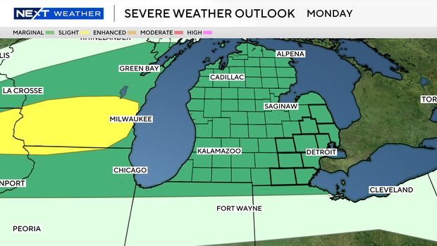
Monday’s weather
A marginal risk (level 1/5) is in place for Monday night, meaning only isolated severe storms are expected, mainly after 7 p.m. through midnight. The primary threats will be hail around 1 inch and a few localized damaging wind gusts, with storms moving quickly west to east, with storm coverage remaining limited.
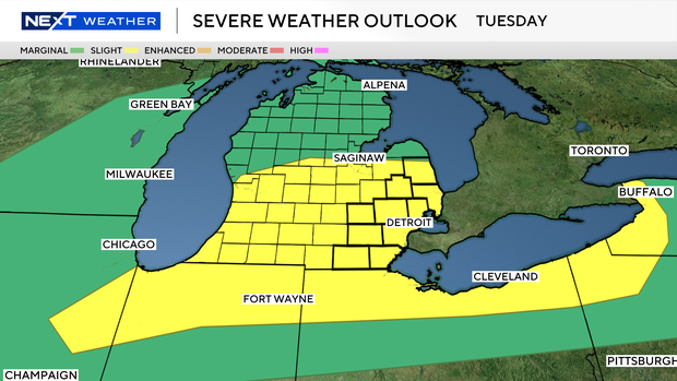
Tuesday’s weather
By contrast, Tuesday brings a Weather Alert Day with a slight risk (level 2/5), indicating a higher chance of more organized and scattered severe storms through the day as a cold front moves through.
On Tuesday, all severe weather hazards are possible, including damaging winds (potentially 60+ mph), large hail, heavy rainfall, and even a low risk of tornadoes, with damaging winds expected to be the main concern.
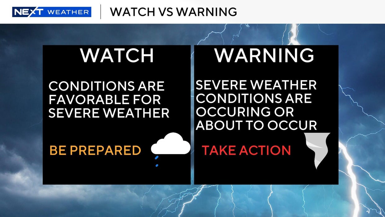
Watch vs. warning
The National Weather Service says a severe weather watch means “be prepared.” It is possible that the weather will reach severe levels during the time frame specified.
A severe weather warning means “take action,” that severe weather conditions have been reported by spotters or can be detected on radar. People are asked to take shelter indoors, away from windows.
It is possible for a tornado warning to be issued without a tornado watch already in effect. This is the scenario that happened in Southwest Michigan on March 6, 2026.

Jim Harding has landed his first commitment on the recruiting trail as offensive line coach in Ann Arbor, as 2027 four-star Sidney Rouleau announced on Sunday night that he will be playing college football for at Michigan.
Rouleau — a native of Canada but now playing high school football at The Brook Hill School in Bullard, Texas — is coming off an unofficial visit to Michigan this weekend. That was his third time in Ann Arbor, as he also visited for the Purdue game last fall and another time a couple summers ago.
Understandably so, Rouleau had great things to say after his most recent trip.
“My visit to Michigan was awesome,” Rouleau told Rivals’ Steve Wiltfong ($). “The energy around the program is contagious, and I really connected with the coaches and players. What excites me most about playing for coach (Kyle) Whittingham and the Wolverines is the chance to be part of building something special. Their vision for the future, combined with the tradition and passion of the fanbase, makes it an opportunity I couldn’t pass up. I’m excited to contribute to their success and also being able to play for coach Harding!”
Rouleau is listed at 6-foot-5 and 240 pounds, per Rivals, but 247Sports has him listed at 6-foot-7 and 269 pounds, so he may be a bit bigger than Rivals’ last update on him. Regardless, the expectation is that he will eventually play one of the tackle positions at Michigan.
Other than the Wolverines, Rouleau also earned offers from Ohio State, Clemson, Penn State, Oregon, Georgia, USC, Wisconsin, Texas, Alabama, Oklahoma Miami, Washington, Florida, Florida State and many others.
Michigan is now up to six total commitments in the 2027 recruiting class, and three of them are offensive linemen — Rouleau, and three-stars Louis Esposito and Tristan Dare. Rouleau also joins four-star edge rusher Recarder Kitchen, four-star safety Darrell Mattison and three-star safety Maxwell Miles in the class.
Rouleau is ranked No. 300 overall on the Rivals Industry Ranking. Check out some of his junior year highlights down below.

The Vols lost four of their last six games heading into the NCAA Tournament, though were impressive against Miami (OH), Virginia, and Iowa State. Their defense is solid (11th) while the offense is productive (31st), perhaps making their No. 6 seed a little misleading. Still, Michigan is the better overall team here, and unfortunately the odds of a third straight year of losing to a No. 1 seed in the Elite Eight are quite high for Rick Barnes and company.
Elite Eight: No. 1 Michigan (34-3) vs. No. 6 Tennessee (25-11)
Date & Time: Sunday, March 29, 2:15 p.m. ET
Location: United Center, Chicago, IL
TV/Streaming: CBS
Oddly, this is the fourth Tournament meeting between these schools since 2010-11, with the prior three favoring the maize and blue. That first contest was a 30-point First Round blowout, followed by a narrow Michigan win in the 2013-14 Sweet Sixteen. The most recent edition was also a close one, with Hunter Dickinson and Eli Brooks each topping 20 points as the No. 11 Wolverines upset No. 3 Tennessee in the Second Round in 2021-22.
Tennessee 2PT Defense: 49.0% (63rd)
The most obvious path to victory for Michigan over Alabama was using its huge size advantage in the paint, yet both Aday Mara and Morez Johnson had games to forget. The bigs will get their chance for redemption on Sunday against a Tennessee defense that is much better than its SEC rival’s, yet is beatable down low. Weak hands and poor finishing will not work against this frontcourt, but the Wolverines have proven they can win physical battles all year.
As fun as March Roddy (Gayle) is, or the rapid emergence of Trey McKenney, Michigan will not win a national championship if it does not get substantial production from the Mara-Johnson duo. Enough others contributed against the Tide to still claim the win, and perhaps that could be possible again in the Elite Eight, but it would give a lot more confidence heading into the final weekend if these two could bounce back in a big way. The Vols have had issues fouling too, so being aggressive at the rim is a must.
Tennessee Offensive Rebounding: 45.1% (1st)
Yes, that is correct — Tennessee grabs nearly half of its own misses. With an effective field goal rate around 140th, this is less extreme than the Texas A&M gameplan last year, but surely no one will be caught sleeping after witnessing the Vols collect 53.3% (!!) of their opportunities against the Cyclones on Friday. Without basically any outside shooting, second-chance points are the only way this offense scores enough to keep it close.
However, since the Duke and Illinois games, the Wolverines have been pretty solid on the defensive glass and should feel capable of at least reducing the impact of Tennessee’s rebounding. The Michigan frontcourt can match up body-to-body, and this is another way Mara and Johnson can make huge contributions. Like Saint Louis and Alabama hitting threes, there will be frustrating stretches of elongated possessions, but the key is just getting enough rebounds to stop any torrent.
Tennessee Defensive 3PT Rate: 44.7% (33oth)
Few teams see more opposing three-point attempts than the Vols do, yet this rarely seems to burn them, as opponents connect on just 30.3% of their shots, which is 11th-best nationally. This resilience is going to be really tested by a Michigan offense that is making 47.3% of its threes in the Tournament thus far after a cold Big Ten Tournament. The touch could certainly cool off on Sunday, but is that a bet Tennessee really wants to take?
If the Wolverines can stay disciplined and keep taking the high-percentage looks, this should be a huge factor on Sunday. While I still would like to see the offense attack the paint, there are too many good shooters on the roster to not take advantage when the defense is passive. Should Barnes choose to start closing out on shooters, there will be paths open to the hoop. Though the metrics consider this a strong defense, it feels like there is an easy way Michigan blows this game open.
Tennessee Adj. Offense: 31st
As a whole, the Tennessee offense appears fine, but the analytics are actually kind of sour on most of the parts. Bad free throw shooting (286th) on modest attempts (103rd), too many turnovers (233rd), limited three-point attempts (329th), and a slow tempo (290th) make me wonder how anything actually happens aside from getting good second-chance looks on offensive rebounds.
Clearly that strategy has worked this year — and over the past two weekends — but the 24-point loss to Florida (with a 17.1% OReb rate) might tell the story of what happens against defenses with size. The best actual shooter is Ja’Kobi Gillespie, who has improved since his combined 6-for-22 effort in two games against Michigan last season, but aside from him and Nate Ament, there is little outside threat.
I do think there will be enough offensive rebounds and tough makes to avoid an instant blowout (though not off the table for the final score), and maybe the Vols’ three-point defense is real, but the ways Michigan can win are so much more numerous than the ways it can lose. Trust the better team to take care of business and move on to Indianapolis next weekend.

Idaho4 minutes ago
Elder José A. Teixeira to speak at BYU-Idaho winter commencement – East Idaho News

Illinois10 minutes ago
Next up for Illinois? UConn in the Final Four

Indiana16 minutes ago
Is ‘The Bachelorette’ happening? This Carmel contestant weighs in

Iowa22 minutes ago
Iowa basketball forward planning to return if granted extra season

Kansas28 minutes ago
Minnesota Twins vs Kansas City Royals Live Stream: How to Watch MLB

Florida1 year ago
Florida High School Football Rankings: Top 25 teams – Oct. 21

Oregon2 years ago
How old is Bo Nix? What to know about Oregon quarterback ahead of 2024 NFL Draft

Connecticut2 years ago
Cleary's 21 help Le Moyne down Central Connecticut State 69-64 in OT

Virginia2 years ago
99th annual Pony Swim held in Virginia

Indiana2 years ago
Indiana Members Credit Union announced as new anchor tenant at Bottleworks District

News5 hours ago
Video: Iran to Allow More Oil Ships Through Strait of Hormuz, Trump Says

Politics6 hours ago
Dem senator warns deportation could let Virginia woman’s illegal immigrant killer ‘escape accountability’

World7 hours ago
Newsletter: G7 ministers to hold talks on war’s economic fallout

News7 hours ago
ICE officers could remain at airports after TSA workers are paid

Politics18 hours ago
Scathing report claims nation’s oldest labor union ‘betrayed’ MAGA members through ‘shocking’ spending
-

 Sports1 week ago
IOC addresses execution of 19-year-old Iranian wrestler Saleh Mohammadi
-

 Miami, FL4 days ago
Jannik Sinner’s Girlfriend Laila Hasanovic Stuns in Ab-Revealing Post Amid Miami Open
-

 New Mexico1 week ago
Clovis shooting leaves one dead, four injured
-

 Politics1 week ago
Schumer gambit fails as DHS shutdown hits 36 days and airport lines grow
-

 Tennessee7 days ago
Tennessee Police Investigating Alleged Assault Involving ‘Reacher’ Star Alan Ritchson
-

 Minneapolis, MN4 days ago
Boy who shielded classmate during school shooting receives Medal of Honor
-

 Science1 week ago
Record Heat Meets a Major Snow Drought Across the West
-

 Technology1 week ago
YouTube job scam text: How to spot it fast