Cleveland, OH
Storm Surveys: 6 Ohio tornadoes confirmed so far following Thursday's severe weather

The National Weather Service is surveying damage across Ohio today following severe weather on Thursday. Six tornadoes have already been confirmed in. Ohio as of 5 p.m. on Friday, with likely more to come throughout the evening and potentially even the weekend. Come back for more information.
1. Crawford/Richland County Tornado: The tornado started near New Washington in Crawford County at 7:54 pm EDT. The tornado ended at 8:13 pm near Plymouth in Richland County. The tornado had estimated wind speeds of 120 mph and was on the ground for over 10 miles.
Storm damage in Richland County
- Rating: EF2
- Estimated Peak Wind: 120 mph
- Path Length /statute/: 10.34 miles
- Path Width /maximum/: 250 yards
- Fatalities: 0
- Injuries: 0
The tornado began along Marsh Road just northeast of New Washington in Crawford County. The tornado caused damage to trees and homes as it moved eastward across Auburn Township. The tornado increased in intensity as it tracked eastward along Kenestrick Road, damaging multiple residences and outbuildings. The tornado destroyed a single-wide manufactured home and an outbuilding before moving east into Richland County. The tornado tracked east-southeast along West Road and Opdyke Road, crossing Ohio State Route 98, Ohio State Route 61, and Ohio State Route 191 before ending near Willet Road between Opdyke Road and Richards Road. The tornado caused extensive damage to homes, outbuildings, trees, and power poles along the path.
NEWS 5
NEWS 5

2. Logan County Tornado: A high-end EF2 (at least) tornado was confirmed near Orchard Island/Indian Lake in Logan County, Ohio. The National Weather Service office in Wilmington, OH, has confirmed at least a high-end EF2 touched down near Orchard Island in Logan County, Ohio. Survey teams also confirmed an EF3 tornado touched down near Lakeview in Logan County, OH. This is the same tornado that was responsible for the damage in the Orchard Island area.
Additional information will be made available once the survey teams have reviewed the scope of the damage. The survey is in relation to the severe thunderstorms that moved through the area on March 14, 2024. A final assessment, including the results of the survey, is expected to be completed within a few days.

News 5
3. Hancock County Tornado: An EF-1 tornado with maximum estimated winds of 105 MPH developed in Orange Township near Mount Cory in southwestern Hancock County at 7:30 pm EDT on Thursday. This was close to the intersection of Township Road 29 and Township Road 56. The tornado was on the ground for six minutes as it tracked 3.3 miles towards the east, lifting in Van Buren Township near Jenera (near Township Road 60, south of Township Road 32). The tornado damaged 5 homes and damaged or destroyed several farm buildings. The maximum width was about 100 yards.
- Rating: EF1
- Estimated Peak Wind: 105 mph
- Path Length /statute/: 3.35 miles
- Path Width /maximum/: 100 yards
- Fatalities: 0
- Injuries: 0

News 5
4. Mercer County Tornado: . The National Weather Service in Wilmington, Ohio, has confirmed an EF-1 tornado occurred in far western Mercer County, OH, Thursday afternoon. The survey remains ongoing at this time, with additional details still to come. Additional information, including tornado-estimated maximum wind speeds and track data, will be made available later this evening. A final assessment, including the results of the survey, is expected to be completed later this evening or tomorrow.
5 and 6. Mercer and Auglaize Counties Tornadoes: The National Weather Service in Wilmington, Ohio, has confirmed a second EF1 tornado occurred in Mercer and Auglaize counties in Ohio on March 14. This tornado is believed to have started near Celina and ended north of Moulton. This is in addition to another EF1 tornado that occurred in western Mercer County, west of Celina. Additional information, including tornado-estimated maximum wind speeds and track data, will be made available later this evening. A final assessment, including the results of the survey, is expected to be completed and transmitted via a Public Information Statement later Friday evening or tomorrow.
The National Weather Service in Wilmington, Ohio, also confirmed an EF1 tornado in Licking Co and an EF1 in Switzerland Co (Indiana) thus far. Surveys are still ongoing.
What’s the strongest tornado?
What’s the most destructive tornado?
EF Scale: The Enhanced Fujita Scale classifies tornadoes into the following categories:
- EF0…..65 to 85 mph
- EF1…..86 to 110 mph
- EF2…..111 to 135 mph
- EF3…..136 to 165 mph
- EF4…..166 to 200 mph
- EF5…..>200 mph
Strong storms leave trail of destruction across Ohio
Want the latest Power of 5 weather team updates wherever you go? Download the News 5 App free now: Apple|Android
Download the StormShield app for weather alerts on your iOS and Android device: Apple|Android
Click here to view our interactive radar.
Read and watch the latest Power of 5 forecast here.
Follow the News 5 Weather Team:
Mark Johnson: Facebook & Twitter
Trent Magill: Facebook & Twitter
Katie McGraw: Facebook & Twitter
Phil Sakal: Facebook & Twitter


Getty
CLEVELAND, OH – JUNE 08: LeBron James #23 of the Cleveland Cavaliers throws a pass against the Golden State Warriors in the first half during Game Four of the 2018 NBA Finals at Quicken Loans Arena on June 8, 2018 in Cleveland, Ohio. NOTE TO USER: User expressly acknowledges and agrees that, by downloading and or using this photograph, User is consenting to the terms and conditions of the Getty Images License Agreement. (Photo by Jason Miller/Getty Images)
LeBron James could return for a final run with the Cleveland Cavaliers with a massive caveat, and it involves center Jarrett Allen, who has been one of the team’s defensive anchors.
According to ESPN insider Brian Windhorst, the Cavaliers could get LeBron from the LA Lakers in exchange for Allen, a center the Lakers would want to pair with their franchise superstar, Luka Doncic.
However, Windhorst said James would first want to go to Cleveland to make the deal happen. On the other hand, such a trade is a no-brainer for the Lakers.
“There is a thought process in Los Angeles where they have to sign-and-trade LeBron James for Jarrett Allen. And I think if the Cavs are willing to do that, they can have LeBron,” Windorst said via ESPN Cleveland radio.
“Obviously, LeBron would have to want to sign with the Cavs, but if your pathway to paying LeBron the money is to trade Jarrett Allen for him, the Lakers would kill for Jarrett Allen. Kill for him. All right? They would do that deal in 17-tenths of a second.”
How A LeBron James-Jarrett Allen Deal Would Work
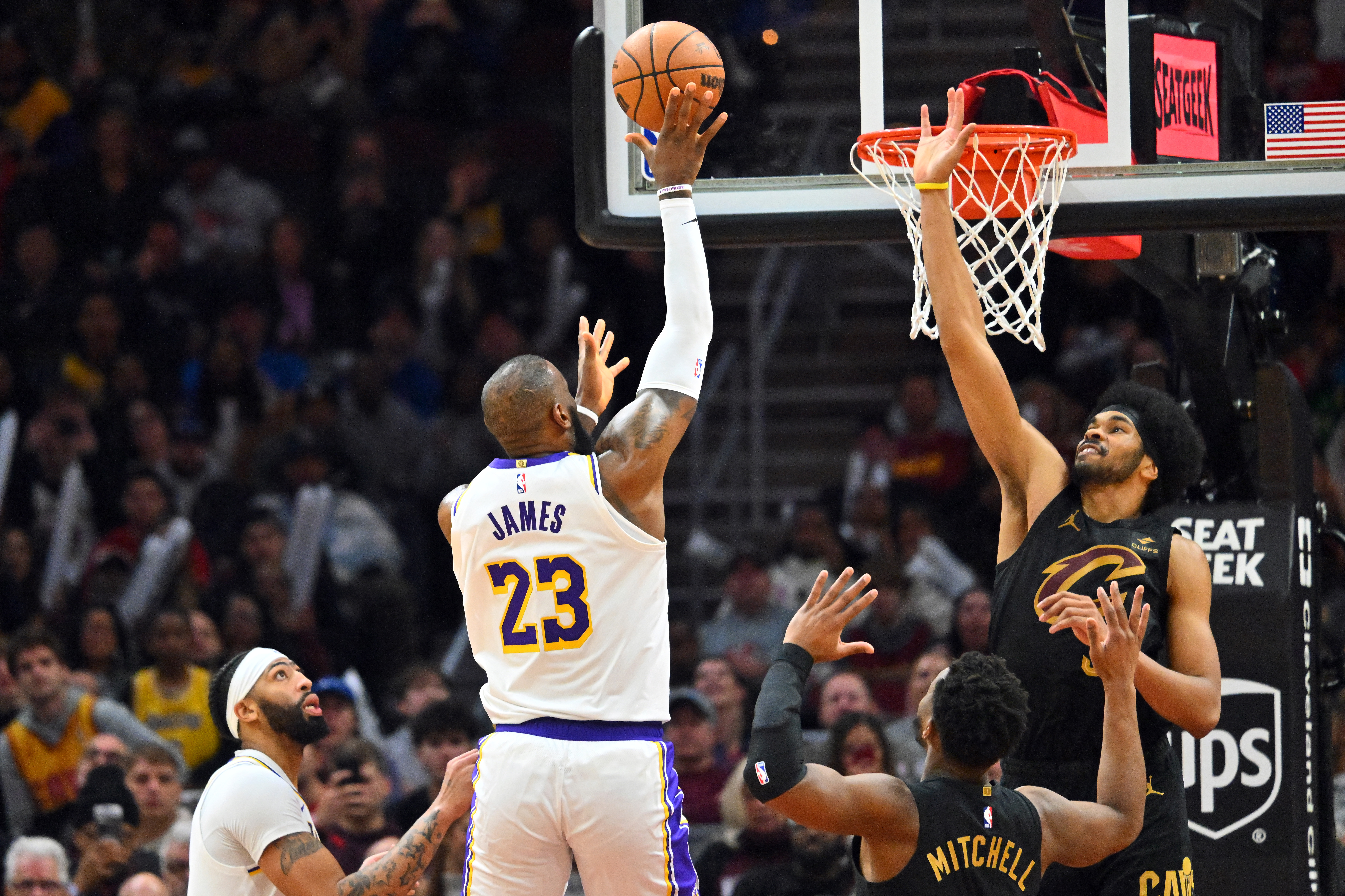
GettyCLEVELAND, OHIO – NOVEMBER 25: LeBron James #23 of the Los Angeles Lakers shoots over Jarrett Allen #31 of the Cleveland Cavaliers during the fourth quarter at Rocket Mortgage Fieldhouse on November 25, 2023 in Cleveland, Ohio. The Lakers defeated the Cavaliers 121-115. (Photo by Jason Miller/Getty Images)
LeBron James is an unrestricted free agent after his contract with the Lakers ended in the past season.
If they were to trade Allen, the Cavaliers could accommodate James’ expected hefty salary, as reports indicated that he is not willing to take a pay cut on his next contract.
There have been rumors about retirement for James and a possible homecoming once more to Cleveland over the past few months, but there are no decisions yet on his future.
There is no word yet about James’ contract value or how long a contract he would sign for, if he is to remain an active NBA player beyond 41 years old.
On the other hand, Allen is locked into a highly secure financial situation after signing a three-year, $91 million contract extension with the Cavaliers.
James last played with the Cavaliers in 2018, leading them to the NBA Finals, but they got swept by the Golden State Warriors. After that NBA Finals stint, he signed with the Lakers and has stayed in Los Angeles since then.
Such a deal suits the Lakers’ biggest offseason objective of getting an A-list center, as reportedly requested by Luka Doncic.
LeBron James’ Future Remains Up In The Air
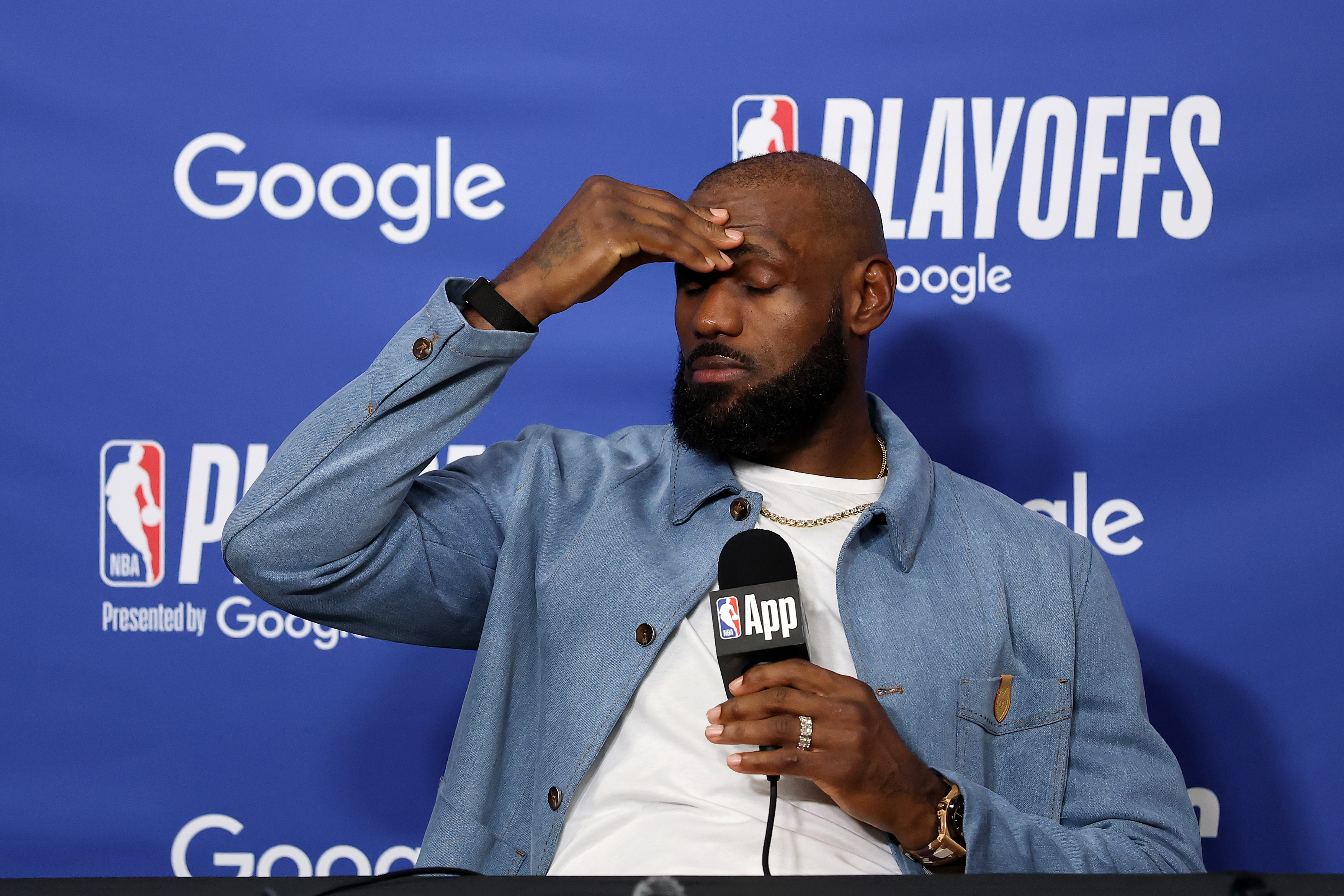
GettyLOS ANGELES, CALIFORNIA – MAY 11: LeBron James #23 of the Los Angeles Lakers speaks to the media during a press conference after the game against the Oklahoma City Thunder in Game Four of the Second Round of the NBA Western Conference Playoffs at Crypto.com Arena on May 11, 2026 in Los Angeles, California. (Photo by Luke Hales/Getty Images)
LeBron James, who had won an NBA championship with Cleveland in 2016, has been contemplating many things at this juncture of his life.
As retirement looms and Father Time starts to creep in, James is expected to decide on his career in the coming weeks.
Right now, according to ESPN’s Ramona Shelbourne, James’ future remains up in the air.
“LA is the first team he can talk to because they’re their own free agent,” Shelburne said during her interview on SportsCenter. “My understanding is they had initial conversations with LeBron James’ representative, but he has not even fully committed to returning next year in these conversations.”
James’ decision is one of the most awaited ones in free agency as teams could still be interested in getting one of the greatest players of all time for a final hoorah in the league.
Rob Andrew Lo Rob Andrew Lo is a writer at Heavy Sports and is covering the NBA. He has covered local, collegiate, professional and international sports in various sites. He was the sports editor of The Varsitarian, the official student publication of University of Santo Tomas, and a sports, entertainment, and lifestyle writer for Rappler.
A Journalism graduate from the University of Santo Tomas, he has built his voice across both collegiate and international platforms, previously contributing NBA coverage to Fansided and Sportskeeda.
More about Rob Andrew Lo

The Cleveland Cavaliers have traded out of the 2026 NBA Draft.
The Cavs had the No. 29 overall selection on Tuesday night. But Cavs President of Basketball Operations Koby Altman decided to trade that selection to the Sacramento Kings in exchange for No. 34 overall and a future second-round selection.
At No. 29 overall, the Cavs will send the Kings UConn forward Alex Karaban.
“It’s in the distant future,” a source told cleveland.com’s Chris Fedor about the future second-round selection acquired in this deal.
Reports from Fedor surfaced early Tuesday morning that the Cavaliers could be interested in bailing out of the first round. By late Tuesday night, Altman was able to execute a trade that sets the Cavs up for further flexibility in the offseason.
Why the Cavs traded out of No. 29 overall
The Cavaliers would’ve owed the No. 29 pick a guaranteed salary just under $2 million.
Because the Cavs are in the lone second apron – and could be looking to shed salary this offseason – ditching the No. 29 overall pick saves the Cavaliers a couple of bucks.
Second round picks are non-guaranteed, two-way deals. That gives the Cavs the financial flexibility they’re looking for.
What the Cavs could do at No. 34 overall
This is a talented draft class. A few high profile players slid into the second round.
UNC center Henri Veesaar is still waiting to hear his name called. The 7-foot center could be a backup to Jarrett Allen and Evan Mobley. Duke wing Isaiah Evans is also still waiting to hear his name called, and could fill a big position of need for the Cavaliers. Arkansas guard Maleek Thomas was consistently mocked to Cleveland, and he slid to Day 2 as well.
There’s always a chance that Altman could trade back again.
Second round draft picks are valuable because they could be used as sweeteners in trades this offseason. For example, in exchange for a team taking on the contract of a player like Dennis Schroder or Max Strus, the Cavaliers might want to attach a second round draft pick to make the package more appealing to a trade partner.
Flexibility should be the name of the game for Altman as he tries to improve Cleveland’s roster this offseason. The Cavs won’t have a first round draft pick until 2028. But bailing out of Tuesday night’s first round will give Altman plenty of options on Wednesday and into the rest of the offseason.
Follow

University of Minnesota star wrestler Max McEnelly won the 2026 NCAA national championship at 184 pounds, and he’s now set to face superstar Bo Nickal at Real American Freestyle (RAF) 12 on August 22nd in Cleveland, Ohio.
THIS MATCH UP🔥
Bo Nickal takes on Max McEnelly August 22 in Cleveland at RAF12.
Tickets in bio. Stream exclusively on @foxnation pic.twitter.com/loEWdeb5pZ
— Real American Freestyle (@RAFWrestlingUSA) June 22, 2026
McEnelly is preparing for his redshirt junior season with the Gophers, and Nickal is 9-1 as a professional mixed martial arts (MMA) fighter, following a storied collegiate wrestling career at Penn State. Their freestyle wrestling match will be contested at 215 pounds.
RAF is an American freestyle wrestling promotion that was founded by Chad Bronstein, Terri Francis, and Hulk Hogan in 2025. The August 22nd show at Rocket Arena will be the one-year anniversary of the promotion. The fights will be broadcast on FOX Nation.
Nickal most recently competed at UFC Freedom 250 at the White House, where he defeated Kyle Daukas via first-round finish. He’s now 6-1 in his UFC career. His match against McEnelly will be his second under RAF. He defeated Jacob Cardenas via decision at the promotion’s first show last summer.
Nickal is 6-foot-1, and he wrestled at 197 pounds at Penn State. He competes at the 185-pound middweight division in the UFC, so he might have a slight size advantage over McEnelly, who’s 5-foot-10. The event will be a high-profile opportunity, as McEnelly continues to establish himself as one of the best pound-for-pound wrestlers in the country.
Follow
-

 Los Angeles, Ca60 minutes ago
Clue may identify SUV in Long Beach hit-and-run that left woman injured
-

 Detroit, MI1 hour ago
Ilitch Companies creates gaming platform, expands beyond Detroit
-

 San Francisco, CA2 hours ago
First of its kind queer museum in San Francisco Chinatown amplifies Chinese LGBTQ artists
-

 Dallas, TX2 hours ago
These children were sold for sex. Then the system failed them again
-

 Miami, FL2 hours ago
Hard Rock Cafe lets Downtown Miami lease lapse after 30-plus years
-

 Boston, MA2 hours ago
Federal judge in Boston bars Trump from implementing proof of citizenship requirement to vote – The Boston Globe
-

 Denver, CO2 hours ago
Denver Broncos Foundation launches extension of ‘ALL IN. ALL COVERED.’ emphasizing youth football participation
-
Seattle, WA2 hours ago
Iran and Egypt to play in Seattle ‘Pride Match’ despite earlier complaints | The Jerusalem Post


