Indiana
Indiana Congressional redistricting explained

SOUTH BEND, IN (WSBT) — On Friday, December 5th, the new Indiana Congressional Redistricting Map passed the Indiana House of Representatives, sending it to the Indiana State Senate.
Indiana University South Bend Political Science Professor, Elizabeth Bennion, said that some communities could potentially be split by the new potential lines.
This could put a strain on on local and county governments to place new voter precincts to fit the new districts.
According to Bennion, the lines were drawn using a super computer that was coded to give Republicans the best opportunity to win all 9 of Indiana’s House of Representative seats.
“One of the things we know about how this map is determined is that super computers are being used to Get as many GOP districts as possible. In other words to try to get as many safe seats for Republican candidates as possible to maximize the likelihood that the GOP will hold all of the seats in the US congressional delegation for the state of Indiana,” said Bennion.
BE THE FIRST TO COMMENT
The State Senate will meet on Monday and will discuss the proposed map.

Indiana
Game times announced for Saturday’s Final Four in Indianapolis

INDIANAPOLIS (WISH) – The 2026 NCAA Division I Men’s Basketball Tournament’s Final Four is set.
Four teams have advanced to the Final Four and will compete for the national championship this upcoming weekend in Indianapolis.
The two national semifinal matchups will take place on Saturday. Tip times for the two games have been announced:
- 6:09 p.m. EDT – No. 3 seed Illinois vs. No. 2 seed UConn
- 8:49 p.m. EDT – No. 1 seed Michigan vs. No. 1 seed Arizona
The winners of Saturday’s games will then play in the National Championship Game on Monday, April 6.
Each game will take place inside Lucas Oil Stadium.
Indiana
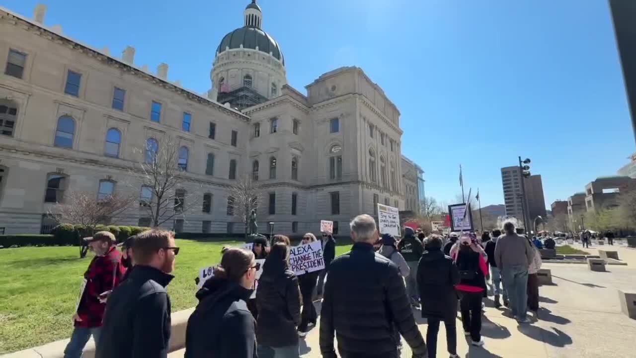
Hundreds gather at Indiana State Capitol for ‘No Kings’ protest

INDIANAPOLIS — Hundreds of Hoosiers gathered at the Indiana Statehouse Saturday morning as part of nationwide ‘No Kings’ events to voice their concerns about the current administration.
WATCH FULL STORY BELOW
Hundreds gather at Indiana State Capitol for ‘No Kings’ protest
“I’m out here today because what’s happening in our government is completely trash,” Donna Sipes told WRTV. “It’s wrong. We need to do something about it.”
“I’m tired of every single day when the TV comes on to see what stupid thing he’s done next,” Lindi Marti said.
WRTV
Attendees noted the growing popularity of the demonstrations.
“This is my fourth one to come to. I didn’t come to all of them when it was really cold, but I’m glad to see that they are getting a lot more people out here every time,” Marti added. “It seems like there’s more and more coming.”
Demonstrators highlighted specific foreign policy concerns, including the administration’s handling of the war in Iran.
“We’re bombing the heck out of them. We’re killing civilians,” Marti’s husband said. “We’re getting ready to send our Marines.”
WRTV

Others focused on the administration’s handling of immigration.
“That’s what I’m concerned about,” Reverend Kenny Little told WRTV. “Little kids, they’re taking them away from their family. And I’m just one of those people, I think everyone got rights.”
Indiana medical students also attended the rally to speak out against changes to the healthcare system.
“We’re really worried about the attacks on the health care system in general, but with Medicaid… current estimates range from anywhere from 325,000 to 450,000 Hoosiers will lose coverage by 2032,” Wade Catt said with concern.
WRTV

With midterm elections approaching later this year, attendees emphasized the importance of now taking action at the ballot box.
“If we don’t vote, then things are gonna not, they’re gonna stay the same,” a protester said.
Meanwhile, Indiana Lieutenant Governor Micah Beckwith says he’s happy to see Hoosiers exercise their First Amendment right to protest.
However, he takes issue with the idea that President Trump is acting like a king. Beckwith says the fact that people have the freedom to protest is proof that the president is not acting like a tyrant.
He acknowledges that bridging the gap between the sides is probably an uphill battle, but believes communication is key.
“I think when you sit down with people face to face, you’re confronted with humanity. There’s another human sitting across that table from you and talking to you. And so, all I have to say, I think that’s probably the thing I would encourage all Hoosiers to do is say, ‘Hey, if you don’t agree with somebody or if you don’t like somebody, why don’t you try grabbing coffee with them? And give it 30 minutes, and just see what happens.’ I bet most of the time people will walk away with a much softer heart and spirit towards that person before they came in,” Beckwith said.
Beckwith is currently on a 92-county tour of the state. He says all sides are welcome to attend his events.
__
Indiana
Young male dead after shooting on Indy’s northeast side

INDIANAPOLIS (WISH) — Police say one “young man” is dead after a shooting at the 1200 block of Rue Rabelais at about 7:19 p.m. according to the Indianapolis Metropolitan Police Department.
That is near the intersection of 56th Street and Binford Boulevard.
Police say the victim was taken to Riley Hospital where he later died. Investigators say they are still working to identify the victim.
There was no known information about a suspect. Police did say that they believe this is a targeted incident.
There was no other information immediately available.
This story has been updated with information from the Indianapolis Metropolitan Police Department.
-

 Sports1 week ago
IOC addresses execution of 19-year-old Iranian wrestler Saleh Mohammadi
-

 New Mexico1 week ago
Clovis shooting leaves one dead, four injured
-

 Miami, FL3 days ago
Jannik Sinner’s Girlfriend Laila Hasanovic Stuns in Ab-Revealing Post Amid Miami Open
-

 Tennessee6 days ago
Tennessee Police Investigating Alleged Assault Involving ‘Reacher’ Star Alan Ritchson
-

 Minneapolis, MN3 days ago
Boy who shielded classmate during school shooting receives Medal of Honor
-

 Politics1 week ago
Schumer gambit fails as DHS shutdown hits 36 days and airport lines grow
-

 Technology1 week ago
YouTube job scam text: How to spot it fast
-

 Science1 week ago
Record Heat Meets a Major Snow Drought Across the West


![[WatchLive]TV!!!] Lithuania vs Georgia 𝐋𝐈𝐕𝐄 Streams ON Tv Channel [WatchLive]TV!!!] Lithuania vs Georgia 𝐋𝐈𝐕𝐄 Streams ON Tv Channel](https://i2.wp.com/cdn1.edgedatg.com/aws/v2/abc/ABCUpdates/blog/4233167/1f510177bdba686174bb0267c66389ca/528x299-Q90_1f510177bdba686174bb0267c66389ca.jpg?w=400&resize=400,240&ssl=1)
![[WatchLive]TV!!!] Lithuania vs Georgia 𝐋𝐈𝐕𝐄 Streams ON Tv Channel [WatchLive]TV!!!] Lithuania vs Georgia 𝐋𝐈𝐕𝐄 Streams ON Tv Channel](https://i2.wp.com/cdn1.edgedatg.com/aws/v2/abc/ABCUpdates/blog/4233167/1f510177bdba686174bb0267c66389ca/528x299-Q90_1f510177bdba686174bb0267c66389ca.jpg?w=80&resize=80,80&ssl=1)


