Science
Monster earthquake could sink swath of California, dramatically heightening flood risk, study says

A long-feared monster earthquake off California, Oregon and Washington could cause some coastal areas to sink by more than 6 feet, dramatically heightening the risk of flooding and radically reshaping the region with little to no warning.
Those are the findings of a new study that examined the repercussions of a massive earthquake on the Cascadia subduction zone, which stretches from Northern California up to Canada’s Vancouver Island.
The study, published Monday in the journal Proceedings of the National Academy of Sciences, concluded that in an earthquake scenario with the highest level of subsidence, or land sink, the area at risk of flooding would expand by 116 square miles, a swath that’s 2½ times the size of San Francisco.
Such a scenario would more than double “the flooding exposure of residents, structures and roads,” and officials would need to contend with a future of “compromised roadways and bridges,” as well as lifelines and infrastructure that are either more frequently flooded or permanently inundated, the study’s authors wrote.
In other words, a powerful earthquake in this area would risk “drastically altering shorelines and causing profound, lasting impacts to coastal populations, infrastructure, and ecosystems,” the study said. Unlike relative sea-level rise that’s driven more gradually by climate change, a rise resulting from a major earthquake “will happen within minutes, leaving no time for adaptation or mitigation.”
The last megaquake on the Cascadia subduction zone, registering a magnitude 9, occurred in 1700. Based on archaeological evidence, villages sank and had to be abandoned, according to the U.S. Geological Survey.
This map shows the location of the Cascadia subduction zone.
(FEMA)
From California’s North Coast to Washington state, scientists say, the next great earthquake — magnitude 8 or higher — could cause land to sink by 1.6 to 6.6 feet, the same range seen during the 1700 earthquake.
Currently, more than 8,000 people live in flood plain areas along estuaries in the Cascadia coastal region. But in the event of a high level of subsidence after an earthquake, that figure would nearly triple to more than 22,000, the study calculates.
Nearly 36,000 structures would be threatened by the resulting quake-influenced flood plain, a 168% increase from the current figure of about 13,000.
And an additional 777 miles of roadway would be in the new flood plain, nearly tripling the at-risk total to 1,212 miles of road.
The flood plain is defined as areas that have at least a 1% chance of flooding each year, which is considered to be “high risk,” according to the Federal Emergency Management Agency. These are areas that have at least a 1-in-4 chance of flooding during a 30-year mortgage. Flood insurance must be purchased by home and business owners in high-risk areas with mortgages from federally regulated or insured lenders.
Radiocarbon dating suggests there have been more than 11 great earthquakes off the shore of California’s North Coast, Oregon and Washington state over the last 6,000 to 7,000 years — recurring every 200 to 800 years, the study said.
“Gradual climate-driven sea-level rise is not the only inundation threat,” the study said. “Coastal subsidence from the next great [Cascadia subduction zone] earthquake may produce” more than 3 feet of sudden relative sea-level rise sooner than otherwise expected.
When discussing a future megaquake on the Cascadia subduction zone, “We often hear about the tsunami and the shaking. But there’s the subsidence that’s going to persist — for decades to centuries —after the earthquake, and just totally alter the flood plains,” Tina Dura, assistant professor of geosciences at Virginia Tech and the study’s lead author, said in an interview.
One estimate published by FEMA is that a magnitude 9 earthquake along the full length of the 800-mile fault zone would leave 5,800 dead from the earthquake alone. An additional 8,000 would die from the resulting tsunami that could rise as high as 80 feet and offer coastal areas as few as 10 minutes of warning. Total economic losses could hit $134 billion.
In the 1700 Cascadia megaquake, oral histories describe tsunamis more than 50 feet high wiping out coastal villages. In Anacla, a village on what is now called Vancouver Island, only 1 out of more than 600 people survived, according to the U.S. Geological Survey.
The tsunami was so strong that it uprooted trees. When it finally receded, treetops were found strewn with trash and victims’ limbs. “Ghost forests” of rot-resistant trees found in tidal marshes and estuaries in the region are evidence that land sank during the quake and drowned the trees, the USGS said.
The results of the latest study should be a wake-up call to residents and government officials considering a postquake response, scientists say. There already are parts of U.S. Route 101 that routinely flood during exceptionally high king tides, Dura said, “and places like that could be kind of a hot spot for seeing flooding right away after the subsidence” following a megaearthquake.
Another factor officials should consider is whether crucial infrastructure, such as airports, would fall within the quake-expanded flood plain, scientists say.
Authorities may also want to consider avoiding building infrastructure such as schools, fire stations and wastewater treatment plants in areas “that we’ve shown are likely to become in the flood plain,” Dura said.
Notable areas at risk of land sinking after a megaquake along the Cascadia subduction zone, according to the study, include:
- California’s Humboldt Bay region, including the area around Eureka and Arcata.
- In Oregon, Waldport and Bayshore along Alsea Bay; Newport and South Beach along Yaquina Bay; and Gearhart and Seaside along the Necanicum River.
- In Washington, the Willapa Bay area, including the communities of Long Beach, Ocean Park, Tokeland and Raymond; and the Grays Harbor area, including Ocean Shores, Westport and Aberdeen.
Traditionally, scientists and government officials have focused on climate-change-driven sea-level rise to calculate the projected increased risk of coastal flooding. But the study suggests that neglecting the role of major earthquakes would be shortsighted.
“Earthquake-driven coastal subsidence following recent historical earthquakes has had severe consequences for communities, leading to permanent land loss, infrastructure damage and forced relocation,” the study said.
One example was the magnitude 9.1 earthquake off Japan’s east coast in 2011, which caused some land to sink by up to 3 feet. In one area of the town of Ishinomaki, the sinking land forced people to contend with regular flooding, according to news reports.
Another magnitude 9.1 earthquake that struck near Sumatra, Indonesia, in 2004 caused land subsidence of up to 3 feet. Areas used for aquaculture have since suffered chronic tidal flooding, leading to oversalinization, and land has been lost, the study said.
The magnitude 9.2 earthquake in Alaska in1964 caused land to sink by more than 6 feet along the coast, “rendering roads, docks and waterfront areas uninhabitable, in some cases necessitating relocation of communities to higher ground or raising waterfront facilities and airstrips above high tide,” the study said. In some places, the subsidence was even more severe.
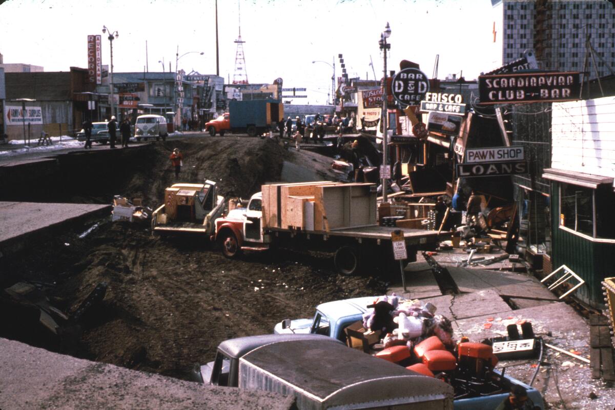
Before the magnitude 9.2 earthquake of 1964 in Alaska, the sidewalk in front of stores on the right-hand side of this photo from Anchorage were level with those on the left.
And a magnitude 9.5 earthquake in Chile in 1960 caused up to 8 feet of coastal subsidence, “permanently submerging coastal pine forests and farms and converting them to intertidal marshes, and flooding coastal towns and forcing residents to abandon homes,” the study said.
Besides Dura, there are 19 other co-authors to the study, with affiliations including Singhofen Halff Associates of Orlando, Fla.; the University of Oregon; Rowan University; the University of North Carolina Wilmington; Durham University; the USGS; Cal Poly Humboldt; the Oregon Department of Geology and Mineral Industries; the University of Hong Kong; and Nanyang Technological University in Singapore.

new video loaded: NASA Announces Artemis III Crew
transcript
transcript
NASA Announces Artemis III Crew
NASA announced the crew of Artemis III mission, which will fly to low-Earth orbit to test rendezvous and docking maneuvers with one or two lunar landers.
-
“I am excited to welcome you as the next crew in the Artemis journey to successfully return to the moon — this time to stay.” “I’m honored by the role that I’ve been given. I’m also very humbled by the task in front of us. But first and foremost, I’m grateful.” “So with that, the Artemis II crew, comrade, hands you the baton. You got the controls.” “As you know, we had a significant anomaly at our Launch Complex 36A on May 28. We’ve redoubled our efforts and are moving forward.”
By Alisa Shodiyev Kaff
June 9, 2026
Science
Santa Monica Mountains’ last steelhead trout survived the Palisades fire — and even had babies

Scientists feared the Santa Monica Mountains’ last remaining steelhead trout were dead, smothered by debris flows unleashed by the Palisades fire.
But the endangered fish surprised them: A team of biologists recently spotted 30 of the rare trout — and 21 babies — in Topanga Creek.
“There was a lot of happy dancing in the creek,” said Rosi Dagit, principal conservation biologist for the Resource Conservation District of the Santa Monica Mountains, which works with public and private landowners to conserve natural resources.
That’s because the steelhead here are endangered, at both the state and federal levels. Once, they swam in most streams of the Santa Monicas, but their numbers plummeted amid overfishing and coastal development. Increasingly frequent wildfire has further stressed their habitat. Topanga Creek, a biodiversity hot spot, is home to their last known population in the mountains that stretch from the Hollywood Hills to Point Mugu in Ventura County.
The trout that were spotted, including this one, are part of a distinct Southern California population that’s listed as endangered at the state and federal levels.
(RCDSMM Stream Team)
The California Department of Fish and Wildlife spearheaded a complex mission to rescue trout threatened by the Palisades fire that sparked in January 2025.
Time was of the essence. The fire hadn’t yet been fully contained. But rain was on the way, which would sweep massive amounts of sediment from the denuded hillsides into the water. Fish are often killed this way.
Crews stunned the fish with electricity, scooped them up in buckets, trucked them to a hatchery and ultimately moved them to Arroyo Hondo Creek in Santa Barbara County.
Within days, Topanga Creek was choked with mud. Some assumed the fish left behind were goners.
But in March, the conservation district’s team found four. The following month, when water conditions were clearer, they saw more.
“These fish continue to amaze me,” said Kyle Evans, environmental program manager for the state Department of Fish and Wildlife, who had seen the damage to the creek. “I had seen populations get wiped out in similar situations. So when I heard, I was thrilled.”
Evans surmises the fish that survived were in an area of the creek where less charred material and sediment were swept in.
“These fish likely hunkered down, were hiding under some rocks or places to try to get away from the main concentration of flow,” he said. “And luckily they weren’t buried.”
The ones that were spotted were fairly small, around 6 to 14 inches. Rainbow trout and steelhead trout are the same species, but with different lifestyles. If the fish remain in freshwater, they’ll be considered rainbows. However, they can migrate to the ocean and become steelhead, where they typically grow larger before returning to their natal waters to spawn.
Topanga Creek hasn’t fully recovered from the damage it sustained, but scientists say it’s looking better. Surveys last year were “so depressing,” Dagit said, with very few animals, and stretches that were essentially transformed into flat roads from all the sediment buildup. Some of the riparian canopy burned right down to the creek.
Then came 32 inches of rain over the last nine months, scouring out and moving sediment, creating deeper pools. Dagit said they recently found newt egg masses for the first time in years, as well as a few adult newts and many frogs. Plants that provide cover are starting to recover.
She provided photos comparing certain pools last year and this year, some dramatically transformed. In September 2025, the Shrine Pool could have been an overgrown hiking trail. This April, it was filled with shallow water.

The Shrine Pool in September 2025, left, and the same location in April 2026, right, with RCDSMM’s Isaac Yelchin donning a wetsuit.
(RCDSMM Stream Team)
Topanga Creek is home to another endangered fish, the small but hardy northern tidewater goby, often described as cute. Not long before the trout operation, Dagit led a rescue of hundreds of these fish too. Many were repatriated to the lagoon at the mouth of the creek in a moving ceremony last June.
There’s still the matter of what to do with the trout that were moved to Santa Barbara County last year. Evans would like to bring them home to the Santa Monicas at some point, but isn’t sure if it will happen. On one hand, they could bolster the small, genetically isolated surviving population. On the other, they might inadvertently bring in a disease or bacteria. There is some time to decide. Evans estimates the creek still needs to recover for two to three more years.
For now, the fish are functioning fine in their adopted creek. Experts worried the trauma wrought by the move would disrupt their spawning process, but they had babies that spring. This year, they spawned again.

The Pacifica Municipal Pier was shut down and taped off Thursday after city workers noticed cracks running through the landmark structure and concrete chunks falling into the ocean.
It’s just one of many coastal California structures that have recently crumbled under pressure from a rising and relentless ocean.
Officials from the small, beach city south of San Francisco said the pier was closed due to “cracking, separation, and displacement of the concrete walkway and structural elements.”
It will stay closed while structural engineers asses its safety.
Photos taken by city employees show a wide crack that runs from top to bottom and across the structure as well. Other photos show a large horizontal crack under the foundation of a small restaurant on the pier, the Chit Chat Cafe.
The cafe was also shut down.
This is not the first time the 53-year-old pier has shown signs of stress. In 2021, part of it was shut down after handrails along the edge collapsed. And in 2023, after a series of storms pummeled the Central California coast, damaging parts of the pier, the structure was partially closed for more than year.
Those same storms caused extensive damage in Aptos and Capitola, 70 miles south, where piers and waterfront infrastructure were swept away or damaged.
In 2024, a 150- to 180- foot section of the Santa Cruz wharf was ripped off by powerful waves.
At least 10 of the state’s dozens of coastal public piers were closed for part or all of 2024 due to structural damage sustained in winter storms since 2022. At least five others have longer-term upgrades planned to address structural issues.
“These things are costly to maintain,” said Zach Plopper, senior environmental director at Surfrider. “They are a part of our California coastal culture in many ways, but we’re going to need to reckon with, one, the state that they’re in, and two, the continuous and worsening threats they’re going to experience,”
He said most of the piers were constructed in the early 1900s, and they weren’t built to withstand decades of rough seas, storms and rising sea level.
“With this incoming El Niño, which is forecasted to be significant, and this marine heat wave we’re in the midst of, we’re kind of in uncharted waters as far as what this winter could bring in terms of storms and swells to the California coast, and we’re likely going to see a lot more damage,” he said. “Not just piers, but roads and other coastal infrastructure up and down the state.”
There was no storm in Pacifica earlier this week, so no single event could be blamed for the destruction.
However, a 2025 report from an outside engineering firm, GHD, found that several sections of the pier were in “poor” or “serious” condition, and they recommended closure before anticipated storms or events that could “subject the piles to high winds, swells and large waves.”
The firm found several areas of the pier where concrete was missing and rebar was exposed and corroding.
“The pier has continued to experience high winds and large waves in a harsh marine environment,” the engineers wrote in the report, noting that continuous exposure to seawater or marine spray was “detrimental” to the structure.
A 2023 city report estimated it would cost $19 million to repair.
That same year, a state law was enacted to require local governments along the California coast to plan for sea level rise in the coming decades.
Sea level has risen some 8 inches, on average, along the coast in the past 150 years, Plopper said, and researchers anticipate another foot in the next 25 years.
“We’re going to see profound shifts on our coastline, none that we have ever experienced before, and building static structures on the coast just doesn’t work all that well,” he said. “We’re going to have to make some really hard decisions.”
-

 Los Angeles, Ca1 hour ago
Los Angeles High School locked down as police search for armed juvenile
-

 Detroit, MI2 hours ago
‘Diarra From Detroit’ sets date for second season on Paramount+
-

 San Francisco, CA2 hours ago
San Francisco police release video of shootout that critically wounded officer
-

 Dallas, TX2 hours ago
3 Dallas educators among FIFA World Cup volunteers
-

 Miami, FL2 hours ago
Miami Gardens man arrested after fleeing Florida Keys deputies at 125 mph, sheriff says
-

 Boston, MA2 hours ago
Boston gives update on plans for 3 a.m. last call at bars, outdoor drinking areas during World Cup
-

 Denver, CO2 hours ago
One Invitation Can Change a Life: Called By Name Campaign Inspires Future Priests For a Second Year in Denver
-

 Seattle, WA2 hours ago
Survey: What’s the toughest game to start the Seahawks’ season?

