Arizona
DATA: A look at county violent crime rates in Arizona

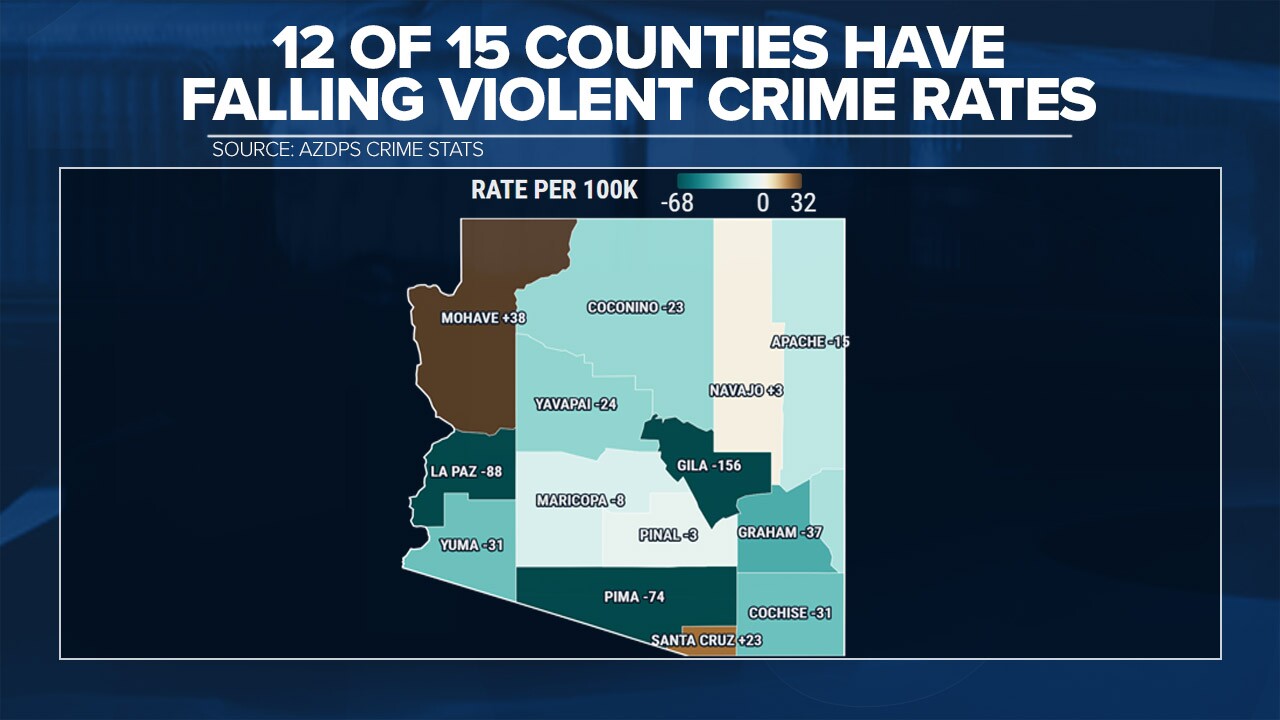
How different are violent crime rates in Arizona’s fifteen counties?
Arizona’s Department of Public Safety maintains a reporting website to track crime statistics.
According to the data and balancing for population, Maricopa County has the highest violent crime rate in the state. There were 224 violent crime incidents in the first half of the year for every 100,000 residents. In nearly every other county the violent crime rate ranged between 110 and 116 per capita.
The lowest crime rates were found in the counties bordering New Mexico and La Paz.
Compared to average violent crime rates in the first half of each of the past five years 2024 rates are down in twelve of fifteen counties. Gila, La Paz, and Pima are reporting significant declines in violent crime rates to their average. The three counties with higher rates in 2024 are Mohave, Navajo, and Santa Cruz.
Along with tracking the crimes themselves DPS also tracks clearance rates. This is when the suspected perpetrator of a crime is either charged or deceased.
A little over one-third of violent crimes in Arizona’s two urban counties, Maricopa and Pima, are reported as cleared.
The lowest clearance rate is in Apahce County at 9% and the highest is in La Paz where the clearance rate is reported at 100%.

ABC 15 also analyzed the number of violent crimes committed by weapon type and found about one in four violent crimes since 2020 involved a firearm across the state. Percentages are higher in Maricopa and Pima, and much lower in Coconino, Navajo, and Gila counties.

In that same time frame, arrestees of a violent crime are overwhelmingly male. About four violent crimes are committed by men for one committed by a woman. The ratio of victims of violent crimes is almost even, with slightly more men than women being victimized.


MARANA, AZ (AZFamily) — Proposals for data centers and ICE detention facilities in Marana are dividing neighbors and turning some against their local leaders.
These are two issues that some Republicans and Democrats are finding themselves agreeing on, as people try to take charge of who and what ends up in their communities.
“Well, first I think everyone on our city council needs to be replaced. What they are doing to Marana and surrounding areas is destroying our future and our kids’ futures,” a Marana resident said.
A recent proposal by the Department of Homeland Security would create an ICE detention center about 3 miles from the community center.
The property proposed for the ICE facility was a minimum-security prison with a capacity of about 500 people. The release said that renovations will increase capacity to 775, but could expand to over 1,300.
DHS officials say the facility would include more exam rooms, a dental area, and other features.
Arizona’s Family asked DHS for some clarification on those numbers and details. DHS released a statement saying, “ICE does not discuss individual pre-decisional conversations, but when a new facility contract is finalized, information will be available on ICE.gov.”
Data center concerns
Meanwhile, a rezoning application for a data center surfaced on the Town of Marana’s website last week.
It’s the second potential data center in the area and has people itching to get to public comment to voice their concerns.
“The detention center- we don’t need that here; no one wants that here. The data center- I mean, we already don’t have water and it’s awful; we don’t need another data center. Look at the ones across the country and what they’re doing,” the Marana resident we spoke with said.
Marana Town Manager Terry Rozema said nothing is set in stone.
“There’s so many factors that could come into considering whether or not something is beneficial to a community,” Rozema said.
Supporters of these projects said they will create jobs.
See a spelling or grammatical error in our story? Please click here to report it.
Do you have a photo or video of a breaking news story? Send it to us here with a brief description.
Copyright 2026 KTVK/KPHO. All rights reserved.

The Pocket Fire burning north of Sedona and sending smoke and ash into Flagstaff has been tricky for firefighters to access because of the steep and narrow terrain through canyons and along cliffsides. These same landscape features mean that many others watching the fire’s rapid progress from afar have worried with little information about which of their favorite hiking trails and scenic viewpoints near Oak Creek Canyon may not look the same again in their lifetimes.
On June 30, the fire perimeter had exceeded 15,000 acres after growing about 4,000 acres overnight. This expansion took the shape of a finger jutting to the west from near the southern edge of the fire while the northern edge broadened along Forest Service Road 9042, where firefighter crews worked to hold it.
For residents of Kachina Village, the community most in the path of the fire’s recent growth and one known to be particularly vulnerable to fire, that northern progress being redirected east and west along the firebreak road was something to celebrate.
For others, fears and questions about singed trails, camping spots, homes and businesses remain.
What is clear is that parts of the distant edge of the popular West Fork trail, which starts at West Fork Trailhead off of U.S. 89A through Oak Creek Canyon and follows West Fork Oak Creek as it twists and turns between stunning red rock canyon walls, are within the Pocket Fire’s active perimeter. The popular panoramic vista from the “Edge of the World” viewpoint in East Pocket off Forest Road 231 was also enveloped by the fire in its early days.
But that doesn’t necessarily mean these areas are unrecoverable as scenic and beloved recreation spots. Wildfires frequently burn discontinuously through forested landscapes, as embers send out new sparks to distant forest patches. So the damage severity from the Pocket Fire in many places is not yet known.
After the Dragon Bravo fire burned 150,000 acres near the North Rim of the Grand Canyon in 2025, a Burn Area Emergency Response team concluded months later that only 1% of the 71,000 park-managed acres within the perimeter showed evidence of a “high severity” burn. The rest had better odds of ecological recovery.
To prevent a need for too much of that in one of the Sedona area’s most treasured spots, though, crews on the Pocket Fire have worked out a “really solid plan to protect all of our identified values and to keep fire out of the bottom of Oak Creek Canyon,” said operations section chief trainee Clyde England of the Southwest Incident Management Team in his morning briefing about the fire on June 30.
England emphasized that crews were focused on keeping the fire out of the West Fork drainage, by conducting backburning efforts and building a buffer on the east side, while limiting progress north toward Kachina Village. They are also working with the Arizona Department of Transportation to remove hazard trees along the roadway, so there is “one less risk we have to worry about” if the fire does jump down into Oak Creek Canyon.
“I want to reiterate that the threat component is still there, as fire is coming down into West Fork,” England said. “There is still a potential for the fire to find some fuels and get some alignment with the winds out of the canyon. We don’t anticipate it. That’s why we still got a big presence up there, just in case some unforeseen event pushes some fire out up on the ridge into that (eastern) corner.”
Another area the team is watching is along the southern edge of the fire in Dry Creek near Bear Sign Canyon, the site of a popular 7-mile hiking trail that passes through “a carpet of ferns with views of white Coconino sandstone cliffs,” according to a nearby business offering lodging for hikers. England said the team has been able to “insert people” into that area over the past few days to build hand lines and work with helicopters on bucket drops to help prevent the fire from spreading to the Seven Canyons area and Enchantment Golf Resort.
The historic Fernow Cabin, a former U.S. Forest Service guard station, is also safe so far, England said, thanks to defensive firing by crews over the weekend that will continue for a few more days to keep the structure intact.
On the northwest edge of the fire, a containment line along Forest Service road 231 is “looking really good,” England said, with a recent expansion of the fire map there reflecting defensive fire efforts rather than wildfire growth. That effort will help protect the power lines to communities in Oak Creek from damage. Fire retardant drops and reinforced dozer and hand lines have helped prevent the fire from progressing over the 536 or 535 roads.
“If we can get it down in this canyon, use the weather patterns, the fuels, the rocky terrain to our advantage, we can find a way to choke that out,” England said. “So our ops are all looking good, our confidence is there.”
Addressing the southwestern corner of the Pocket Fire perimeter, England struck a more somber tone, acknowledging expansion of flames across Round Top Mountain toward Secret Canyon.
That’s the reality of wildfire in the American Southwest, scientists say, in an age of the drying and warming influences of climate change combined with ever-expanding human development and juxtaposed against federal funding cuts.
“The anticipation is that some of this fire will be on the landscape for a while,” he said. “There’s just no access and no way to get folks into that country. You might see that fire and that smoke for a while.”
Joan Meiners is the climate news and storytelling reporter at The Arizona Republic and azcentral.com. Send tips or questions to joan.meiners@arizonarepublic.com or follow her work on Instagram at @joan_bikes_arizona.
Have a news tip? Contact The Arizona Republic and azcentral.com at newstips@arizonarepublic.com.


The Arizona Republic. Here for it. Are you?
You can play a vital role in supporting local journalism that you and your community can trust. Subscribe today.
Arizona Republic
Flags were lowered in Arizona on Tuesday, June 30, in honor of the 19 Granite Mountain Hotshots who died fighting the Yarnell Hill Fire in 2013.
Gov. Katie Hobbs ordered flags be flown at half-staff from sunrise through sunset on Tuesday to honor them on the 13th anniversary of their death.
Sparked by a lighting strike, the Yarnell fire became nationally known as an emblem of tragedy. The crew, which was part of a unique municipal-level firefighting effort, was encircled by flames reaching 2,000 degrees with no way out. All but one of them died.
The blaze was the deadliest for U.S. firefighters since 1933 and the greatest loss of U.S. firefighter life since the Sept. 11, 2001 terrorist attacks.
“Hotshot crews take on dangerous and difficult firefighting to keep Arizona communities safe,” Hobbs wrote in her a statement. “We recognize and honor the sacrifice and bravery of the Granite Mountain Hotshots. This will always be a day we mark with mourning, reflection, and deep admiration for the members of this crew, their families, and the wildland firefighting community.”
Here’s when flags are traditionally lowered in the United States and the difference between half-mast and half-staff.
What is the difference between half-mast and half-staff?
The terms “half-mast” and “half-staff” both refer to lowering a flag to honor or mourn someone, but they are used in different settings.
“Half-mast” traditionally refers to flags flown on ships or at naval stations, while “half-staff” is used for flags flown on land. In the United States, “half-staff” is the term most commonly used for government buildings and public flag displays.
When are flags flown at half-staff in the US?
In the United States, flags are lowered to half-staff on certain national observances and following the deaths of notable public officials.
According to the Arizona state website, the U.S. flag is flown at half-staff on these days:
- Memorial Day, when the flag should be displayed at half-staff until noon only, then raised to the top of the staff.
- Peace Officers Memorial Day, unless that day is also Armed Forces Day.
- Patriot Day.
- National Pearl Harbor Remembrance Day.
- National Firefighters Memorial Day.
The president of the United States may also order flags to be flown at half-staff after the death of a notable public figure. In those cases, the length of time depends on the person’s role:
- 30 days from the death of the president or a former president.
- 10 days from the day of death of the vice president, the chief justice or a retired chief justice of the United States, or the speaker of the House of Representatives.
- From the day of death until the interment of an associate justice of the Supreme Court, a secretary of an executive or military department, a former vice president or the governor of a state.
- The day of death and the following day for a member of Congress.
The governor may also order flags lowered to half-staff after the death of notable current or former government officials or members of the armed forces who die while on active duty.
In Arizona, the governor can also require that the state flag be lowered at all state, institutional and educational buildings. The law also allows the state flag to be lowered on the death of an incumbent elected state officer for seven days beginning on the day following the death of the officer.
Arizona Republic reporter Laura Gersony contributed to this article.
-
Ohio4 minutes ago
Children found in ‘deplorable’ Ohio home were part of same family
-

 Oklahoma11 minutes ago
Oklahoma opens Taiwan Regional Trade Office at State Capitol
-

 Oregon14 minutes ago
Strict fire restrictions in effect on BLM lands in Washington, Oregon ahead of July 4
-
Pennsylvania19 minutes ago
From Chocolate Avenue to the World Cup, how Hershey, Pennsylvania, shaped Christian Pulisic
-

 Rhode Island26 minutes ago
Christ on a Crackuh! Liz McGraw Is Leaving RHORI.
-

 South-Carolina29 minutes ago
South Carolina Lowcountry Community Calendar of Events
-

 South Dakota41 minutes ago
Transparency, data protection laws take effect July 1
-

 Tennessee44 minutes ago
More than 1K Williamson County residents without power amid heat wave

