Alaska
Roadblocks and speed limits: Geoscientists study Alaska’s Denali fault
The 1,200-mile-long Denali Fault stretches in an upward arc from southwestern Alaska and the Bering Sea eastward to western Canada’s Yukon Territory and British Columbia. The long-lived and active strike-slip fault system, which slices through Denali National Park and Preserve, is responsible for the formation of the Alaska Range.
“It’s a big, sweeping fault and the source of a magnitude 7.9 earthquake in 2002, that ruptured more than 200 miles of the Denali Fault, along with the Totschunda Fault to the east, causing significant damage to remote villages and central Alaska’s infrastructure,” says Utah State University geochemist Dennis Newell.
Understanding the restless fault’s mantle-to-crust connections provides critical information for understanding the lithospheric-scale fault’s seismic cycle, says Newell, associate professor in USU’s Department of Geosciences.
He and colleagues Jeff Benowitz, an Alaska-based geochronologist, Sean Regan of the University of Alaska Fairbanks, and doctoral candidate Coleman Hiett of USU, collected and analyzed helium and carbon isotopic data from springs along a nearly 250-mile segment of the fault and published their findings, “Roadblocks and Speed Limits: Mantle-to-Surface Volatile Flux in the Lithospheric Scale Denali Fault, Alaska,” in Geology.
“Active strike-slip faults like Denali have three-dimensional geometries with possible deep conduit connections below the Earth’s surface,” Newell says. “But we don’t know much about how and if these connections are maintained.”
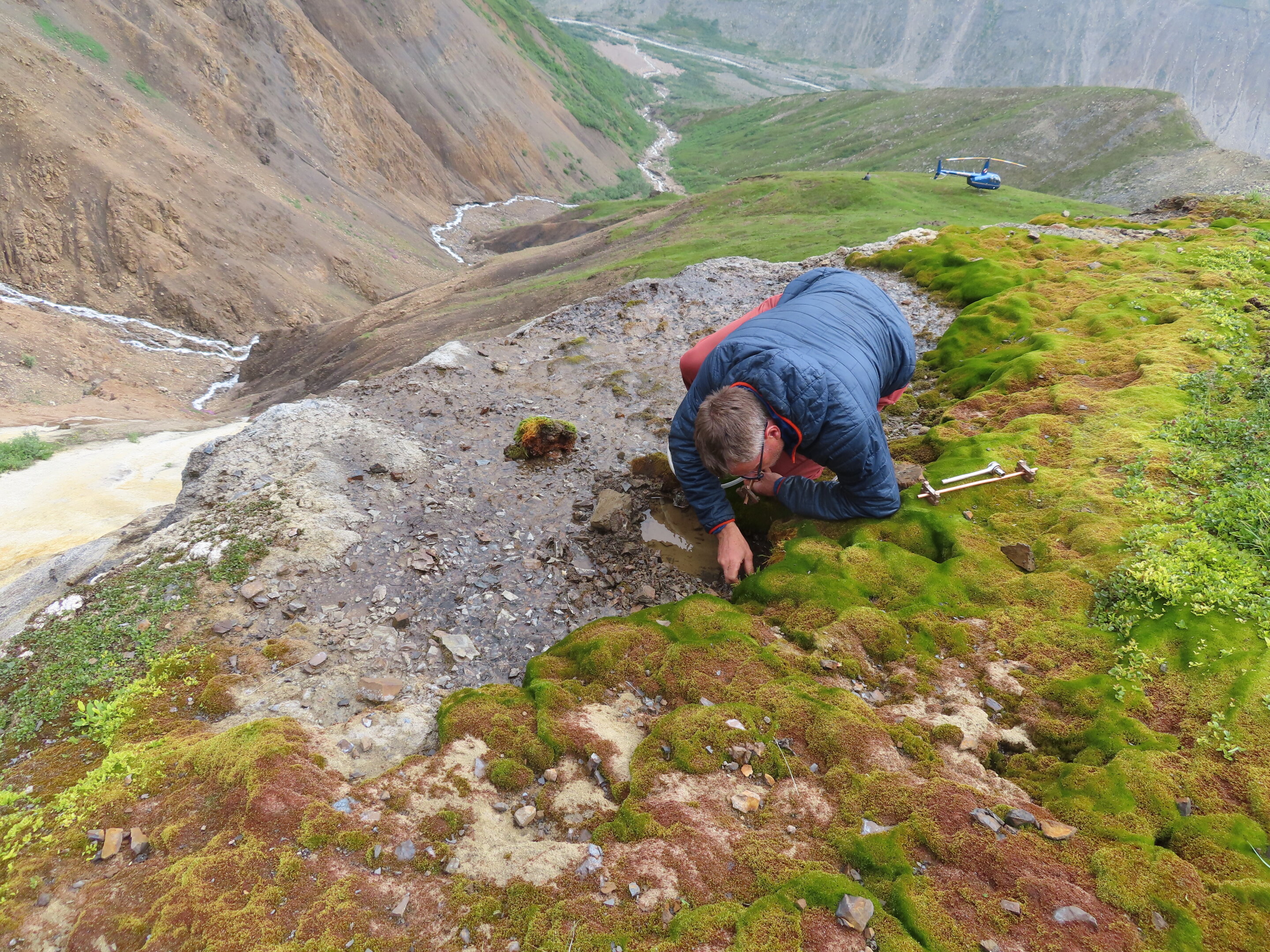
To examine these possible deep connections, Newell and Regan sampled 12 springs along the Denali and Totschunda Faults, by way of helicopter and on foot, to the remote, mountainous regions of Alaska’s interior.
“Helium-3, a rare isotope of helium gas, in springs is a good indicator of whether or not an area has a connection to the Earth’s mantle,” Newell says. “Warm, bubbling springs west of the 2002 earthquake rupture, along the Cantwell segment of the Denali Fault, have a strong helium-3 signature, indicating intact connections to the mantle. In contrast, springs along the ruptured fault segment only have atmospheric gases, suggesting a ‘roadblock’ preventing the flow of mantle helium to the surface.”
These observations, he says, have implications for how groundwater pathways along the fault are changed by earthquakes, and the timescales on which they heal.
“The last major earthquake on the Cantwell segment was 400 years ago, and the helium data suggest those mantel connections have been reestablished,” Newell says. “These bubbling springs are indicative of the possibility of a future large destructive earthquake along the Denali Fault segment near Denali National Park, which receives some 600,000 visitors each summer.”
The geoscientists also seek data on how fast helium can move from the mantle to the crust along active faults.
“That’s the ‘speed limit’ part of our research,” Newell says. “This is important as it reveals mantle-to-surface volatile flux and how fluid pressure gradients may impact fault strength and seismicity along the fault.”
The fault’s mantle fluid flow rates fall in the range observed for the world’s other major and active strike-slip faults that form plate boundaries, he says, including California’s San Andreas Fault and Turkey’s North Anatolian Fault Zone. These types of faults host large, devastating earthquakes, such as February 2023’s deadly earthquake on the East Anatolia Fault, which caused widespread destruction in Turkey and Syria.
“Quantifying crust-to-mantle connections along major strike-slip faults is critical for understanding linkages between deep fluid flow, seismicity and fault healing,” Newell says.
More information:
Dennis L. Newell et al, Roadblocks and speed limits: Mantle-to-surface volatile flux through the lithospheric-scale Denali fault, Alaska, Geology (2023). DOI: 10.1130/G51068.1
Provided by
Utah State University
Citation:
Roadblocks and speed limits: Geoscientists study Alaska’s Denali fault (2023, June 6)
retrieved 6 June 2023
from https://phys.org/news/2023-06-roadblocks-limits-geoscientists-alaska-denali.html
This document is subject to copyright. Apart from any fair dealing for the purpose of private study or research, no
part may be reproduced without the written permission. The content is provided for information purposes only.

Alaska
Cooler weather, rain help firefighters working on Western Alaska fires

The arrival of precipitation, coupled with continued cooler temperatures, helped firefighters working in Western Alaska on Monday.
The handful of fires that makeup the Roundabout Complex outside of Huslia remain the top priority for BLM AFS Galena Zone fire managers. None of the fires are immediately threatening communities at this time.
Firefighters contained the Billy Hawk Fire (#182) and the Billy Hawk 2 Fire (#191) on Monday. Both fires are in monitor status.
The remaining fires in the complex include:
The Moldy Fire (#279), which is still showing heat around the edges of the fire. The fire is unstaffed; however, fire managers are working on a plan to implement point protection for nearby allotments and cabins once resources become available. Satellite imagery puts the eastern edge of the fire about 8 miles from Huslia. Marshland, the Koyukuk River, and a previously burned area are between the fire and the community.
On the Richards Fire (#251), eight smokejumpers worked Monday around the eastern edge of the fire, connecting their fire lines to lakes to prevent the fire’s spread. Firefighters conducting mop up are working 100 feet in from the perimeter of the fire’s edge to ensure hotspots are eliminated and the line is secure. Smokejumpers also improved a temporary helicopter landing pad ahead of the planned arrival of a Type 1 hotshot crew. The fire is 20% contained.
The four smokejumpers assigned to the Caribou Fire (#128) received a para-cargo delivery of structure protection equipment Sunday night. They spent Monday setting up the sprinklers, hoses, and pumps to protect a mine site, historical mining equipment and other structures. A helicopter dropped water on hotspots along the fire’s edge to help slow its spread.
Other fires of interest:
The Nakochelik Fire (#306) is 100% contained. Smokejumpers are working their way 50 feet in from the perimeter to find any remaining hotspots, put them out and secure the line.
The Sardine Fire (#285) was reported shortly after 9:30 p.m. on June 20, and the Snowball Fire (#286) was reported about 9 a.m. the following day. Both fires were about 10 miles north of Council and both were caused by lightning. Fire managers wanted to respond to the Sardine Fire when it was reported, but were unable to do so due to the late hour and lack of available resources. Careful monitoring of both fires has shown no heat and no smoke over the past several days.
A wetter, cooler weather pattern is forecast for western Interior Alaska over the next few days with some areas expected to receive 1/2 inch of rain or more. There’s a chance of thunderstorms across the region, however, which could bring lightning.
-BLM-
Bureau of Land Management, Alaska Fire Service, P.O. Box 35005 1541 Gaffney Road, Fort Wainwright, Ak 99703
Need public domain imagery to complement news coverage of the BLM Alaska Fire Service in Alaska? Visit our Flickr channel!
Learn more at www.blm.gov/AlaskaFireService, and on Facebook and Twitter.
The Bureau of Land Management Alaska Fire Service (AFS) located at Fort Wainwright, Alaska, provides wildland fire suppression services for over 240 million acres of Department of the Interior and Native Corporation Lands in Alaska. In addition, AFS has other statewide responsibilities that include: interpretation of fire management policy; oversight of the BLM Alaska Aviation program; fuels management projects; and operating and maintaining advanced communication and computer systems such as the Alaska Lightning Detection System. AFS also maintains a National Incident Support Cache. The Alaska Fire Service provides wildland fire suppression services for America’s “Last Frontier” on an interagency basis with the State of Alaska Department of Natural Resources, USDA Forest Service, National Park Service, Bureau of Indian Affairs, U.S. Fish and Wildlife Service, and the U.S. Military in Alaska.
Categories: Active Wildland Fire
Alaska
Federal board rejects ‘Mount Carola’ for unnamed summit in Denali National Park
The federal Board of Geographic Names has rejected a proposal to name a summit in Denali National Park and Preserve after a Mat-Su mining pioneer.
Michele Stevens, daughter of Carola June Young, proposed naming the peak “Mount Carola” to honor her mother, and the proposal had been supported by the Talkeetna Historical Society, the Matanuska-Susitna Borough Planning Commission, the Alaska Miners Association and the Alaska Historical Commission, which voted 6-1 to support the nomination.
But on June 12, the domestic names committee of the U.S. Board on Geographic Names rejected the nomination. The board, along with the secretary of the interior, is responsible for maintaining geographic names in the country.
Wendy Sailors, community engagement manager for Alaska State Parks, said that the federal board rejected the Mount Carola name because it violated the policy for names in wilderness areas.
That policy states in part that the board “will not approve proposed names for unnamed features within wilderness areas, including unpublished names in local use, unless an overriding need can be demonstrated by the proponent.”
The unnamed mountain that was to be christened Mount Carola is located just inside the southern border of Denali National Park, inside an “eligible wilderness” area.
That area was added to the original McKinley National Park in 1980 as part of the Alaska National Interest Lands Conservation Act.
Eligible wilderness is not designated wilderness but is managed to preserve its wilderness character, according to National Park Service policy.
Sailors said that the National Park Service did not support the Mount Carola name, and its opposition was shared with federal board members before the final vote.
It is somewhat unusual for an Alaska name nomination to be rejected at the federal level because names must be vetted by the Alaska Historical Commission beforehand.
In December, the federal board approved the names for Arkose Peak and Souvenir Peak in the Hatcher Pass Planning Area. Those names had been suggested by local skiers and mountaineers to clear up a discrepancy between local use and what was actually listed on the map.
On July 10, the board is expected to take up the renaming of “Nazi Creek” and “Nip Hill” in the Aleutians. Those landmarks, on the southeastern side of Little Kiska Island, were federally named in World War II and are expected to be renamed using local Unangax terminology.
Both are located within the Aleutian Islands Wilderness of the Alaska Maritime National Wildlife Refuge.
Originally published by the Alaska Beacon, an independent, nonpartisan news organization that covers Alaska state government.
Alaska
Firefighters Lift 700-Pound Boulder to Rescue Man Pinned Face-Down in Frigid Alaska Creek
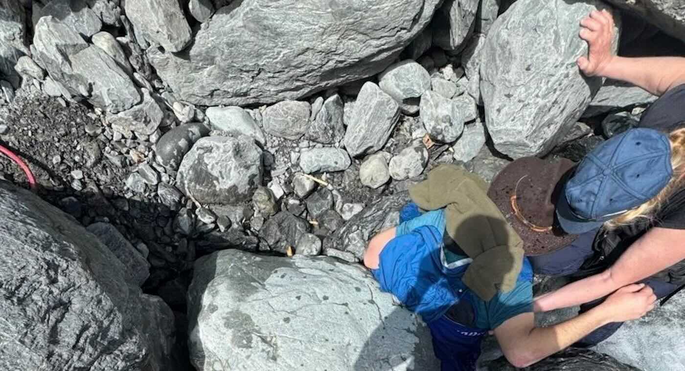
Rescuers described it as an avalanche of boulders—and Kell Morris was lucky to have survived it.
The 61-year-old was hiking with his wife in the Alaskan wilderness south of Anchorage last month, when a single step sent a succession of rocks crashing down the terrain.
Morris fell with them and, when he landed, he was pinned face down in an icy creek by a 700-pound boulder.
“It all came loose… and I was sliding with it,” Morris told KTUU News in Alaska. “Then it was a blur. I went tumbling. ”
“I could hear the noise that large rocks make as they’re rolling over each other. I landed face-down in the river, and then I felt the rock hit me in the back and pin me down.”
Morris’s left leg and hip were pinned tightly to the rocks, but his shoulders were still above the frigid water. Other rocks kept him from getting flattened by the huge boulder, so he still had a chance.
His wife, Joanna Roop, a retired Alaska State Trooper, immediately sprung into action, running to find a cell phone signal about 300 yards away to call 911—and emergency crews used GPS coordinates to organize a rescue attempt.
Fortunately, volunteer firefighter Sam Paperman happened to be working his tourism job in a nearby helicopter and diverted to the scene after the rescue call came in. More responders arrived a few moments later—and they were just in time.
The water level continued to rise in the creek, which was fed by glacier ice fields. Morris’s speech was slurring and he was fading in and out of consciousness as hypothermia set in. His wife continued to hold his head above water.
Emergency crews inflated two airbags typically used for vehicle extractions to help lift the boulder off of Morris, according to a media statement from the Seward Fire Department.
And then, it was time for teamwork.
“It just became an all-hands, brute force of ‘One, two, three, push,’” Seward Fire Chief Clinton Crites said in a quote from CBS News.
“Seven guys were able to lift it enough to pull the victim out.”
STRANGER RESCUE: Dramatic Video Shows Strangers Desperately Fight to Remove Man from Car Engulfed in Flames–And Succeed
Morris spent two days in a hospital for observation, but thanks to the quick actions of his wife, a whole bunch of good fortune, and the efforts of dedicated rescue workers, he pretty much walked away from the 700-pound boulder battle relatively unscathed.
“Every star was aligned,” said Chief Crites, citing the good weather, number of rescuers, cellular service, and the private helicopter tour company that was willing to help.
OCEAN CREATURE KINDNESS: Struggling Manatee Was Close to Dying but Florida Deputy Held it Afloat for 2 Hours
“You couldn’t have made the stars align any better for this guy.”
HAIL THESE FIREFIGHTERS By Sharing the Rescue on Social Media…
-

 Arizona5 days ago
Suspect in Arizona Rangers' death killed by Missouri troopers
-

 News1 week ago
At Least 4 Dead and 4 Missing in West Virginia Flash Flooding
-

 News1 week ago
Oakland County sheriff urging vigilance after shootings of 2 Minnesota lawmakers
-

 Culture1 week ago
Book Review: “The Möbius Book, by Catherine Lacey
-

 Technology1 week ago
Tanks, guns and face-painting
-

 News1 week ago
Video: Trump's Military Parade Met With Nationwide Protests
-
 World1 week ago
At least 100 people killed in gunmen attack in Nigeria: Rights group
-

 Mississippi1 week ago
Miss Mississippi 2025: Who won in the third night of preliminary rounds? Find out here

